• We have updated our Community Code of Conduct. Please read through the new rules for the forum that are an integral part of Paradox Interactive’s User Agreement.

Tinto Maps #19 - 20th of September 2024 - India

Hello everyone, and welcome once again to another Tinto Maps! Today we will be taking a look at India! Yup, a whole subcontinent… Exciting!

Let me say a foreword before I start sharing with you some beautiful maps. Some of you may wonder why we decided to make the entire Indian subcontinent in just one DD, instead of spreading it a bit. There are two reasons for that. The first is the political situation: the Sultanate of Delhi is at its zenith, under Muhammad bin Tughlaq. You will soon see that it rules over more than half of the region, approximately; so splitting that polity into several DDs would have felt weird.

The other is that we felt that a more cohesive approach made sense in this region, as it’s sooo diverse compared to others, that the way we approached it, both for its setup and content, was from the generic to the particular; therefore, we think that it will also help us more when we tackle the review of the region. Speaking of that, don’t worry much about the time available to prepare suggestions; you may already know that we have a backlog of several regions, and therefore weeks, before we hit the Indian review, so you will have plenty of time to research and prepare them. In any case, as it’s a massive task (we know it firsthand), we’ll let you know a bit in advance when we plan to start the in-depth review of it, so you have time to wrap it up.

As a final say, I just want to mention that an old acquaintance of the community, @Trin Tragula , now Design Lead in CK3, helped us to map a big chunk of it. Thanks, mate! And now, maps!

Countries:
Countries.jpg

Colored Wastelands.png

As I just mentioned, the Sultanate of Delhi is at its zenith, under Muhammad bin Tughlaq, extending through the Indo-Gangetic Plain, including Bengal, and to the south, throughout the Deccan. There we have its toughest contender, Vijayanagar, a county that is a bulwark of Hinduism. Other important countries around it are Orissa and Sindh, but much smaller countries generally surround Delhi. You might wonder how it would be possible to stop Delhi from completely controlling the region, then. For this, two things are affecting its capability to achieve it. The first is the base game mechanics: ruling over so many different cultures and religions with low control will be hard. The second is a Situation that involves the Fall of the Sultanate; if Delhi wants to succeed, it will have to fight back against rebellions, which involves the potential independence of the Bengalese countries or newborn ones such as the Bahmanis, and the multiple Indian states around it, which are ready to take over it.

Dynasties:
Dynasties.jpg


Locations:
Locations.jpg

Locations 2.jpg

Locations 3.jpg

Locations 4.jpg
Yes, we are making some adjustments to the coloring of the mapmodes!

Provinces:
Provinces.jpg

Provinces 2.jpg

Provinces 3.jpg

Provinces 4.jpg

Areas:
Areas.jpg

The bug is still there, yes… The area that is to the southwest is Malabar.

Terrain:
Climate.jpg

Topography.jpg

Vegetation.jpg

Here we have a new type of topography: Atolls. We added it some months ago, as we worked on finishing the map of the Pacific Ocean, and it will be the last one added to the game.

Development:
Development.jpg

A new map mode is born! Here you have the development of India. The most developed place is Delhi, which is part of the fertile Gangetic Plain.

Harbors:
Harbors.jpg


Cultures:
Cultures.jpg

Cultures 2.jpg

Cultures 3.jpg
Not an entirely new map, but a glorious one. We chose it to be the one to present how the different cultures could be present in the game for a reason.

Religions:
Religions.jpg

Religions 2.jpg

Religions 3.jpg
India is the birthplace of numerous religions, and that needs to be reflected in the religious map. The main religion is Hinduism, but don’t be deceived by its homogeneous look, as it will be quite deep feature-wise. We also have Buddhism, which is at a low point, after some centuries of prosecutions. Mahayana is a majority in Sindh, although that's not completely exact, as an earlier form of Buddhism was practiced there; we’re also not 100% convinced about it being a majority, as some sources and accounts set the Islamization of the region to be completed under the Ghaznavids, in the 11th and 12th century, while others delay it until the 14th century - we followed the later approach, but we're very open to feedback in this specific matter. Another form of Buddhism is Theravada, which is the most practiced religion in Sailan. Some interesting minorities present in the region are Jains (yellow stripes), Nestorians (the pink stripe in Malabar, which portrays the ‘Saint Thomas Christians’), Jews (which have their own separate culture, ‘Kochini’), and several Animist confessions, of which we’ve already split Satsana Phi, the traditional religion of Tai people, and Sanamahism, the religion of Meitei people. Oh, although it’s not strictly part of the region, the light blue stripes to the north is Bön religion.

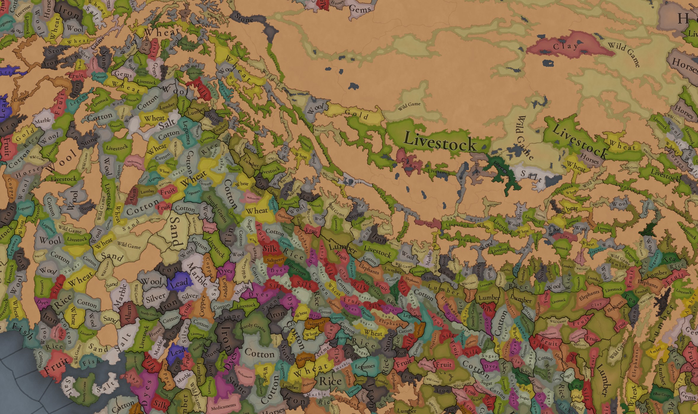
Raw Materials:
Raw Materials.jpg

Raw Materials 2.jpg

Raw Materials 3.jpg

Raw Materials 4.jpg
India was for some time in the period the wealthiest region of the world, one of the main reasons being that it’s incredibly rich in very different types of resources, including some of the expensive ones. That will make for a very interesting economic gameplay.

Markets:
Markets India.png

There are several market centers in India that we think portray well the situation in 1337: Kabul (yes, it’s in Afghanistan, but it’s one for the area of Kashmir), Delhi, Khambat, Calicut, Pulicat, Varanasi, and Chittagong.

Population:
Population.jpg

Population 2.jpg

Population 3.jpg

Population 4.jpg

Population 5.jpg

Population 10.jpg

Population 9.jpg

Population 6.jpg

Population 7.jpg

Population 8.jpg

India has a big population. To be precise, around 95M pops. Delhi is the second largest country in the world in population, with 41M pops, which makes it a behemoth, with very serious governance challenges. I’m also showing this week the progress we’re making with the coloring of the population mapmode; the stripes on several locations mark that they’re overpopulated, as they have more pops living on them than the pop capacity available (something that may be reviewed, as balancing very densely populated regions such as India or China is really challenging).

And that’s all for today! We hope you enjoyed this massive Tinto Maps. Next week we will be taking a look at the Steppe. Which one, you might wonder? Well, the one ruled by the Golden Horde, from Ukraine in the west to Mongolia in the east. Cheers!
 
  • 120Like
  • 98Love
  • 3
  • 3
  • 1
Reactions:
Bro, it has nothing to do with being woke, I am not woke and I want the Kalasha people represented correctly, just change Kafir to Kalasha and it's good. It's not political.
its 1337 not 2024
nouristan is a 19th century renaming after their mass conversion and that only concern a small area.

Kafir is the name , end of the story
 
Can we please divide Tribal religions atleast a few real ones instead of labelling them all into Animism?
Making them all Animism not just grossly simplifies stuff but also makes synchronism between completely unrelated religious groups living miles away with completely different faiths and beliefs. Its very inaccurate that way.
 
  • 1Like
  • 1Love
  • 1
Reactions:
Can we have a direct route from Kalinga to South East Asia? I mean the travel boxes should not be restricted to near coast.

1000033645.png
1000033648.jpg

1000033649.png
1000033650.png


Traders followed the retreating monsoons since ancient age.

Directly jumping to Andaman and Sumatra crossing across the sea instead of following the coast.

Please do not make the middle Bay of Bengal (aka Kalinga Mahodadhi) impassable.


Attachments

  • 1000033646.png
    1000033646.png
    291,2 KB · Views: 0
Last edited:
  • 4Like
Reactions:
Only the Asian Elephant was tamed/domesticated hence a trade good. African elephants were never tamed instead purely used for ivory and other elephant products.
Hannibal attacked Rome with tamed African Elephants. While the north African subspecies went extinct, given that much less closely related elephants have been tamed, why not have the possibility of a Great Lakes state creating elephant units?

Topographical analysis for India​

Plateaus, wetlands and hills - oh my!

I'll summarize first, because this is going to be a lengthy post.
Nomenclature I use is from this map.

General:
- Southern India (Deccan) is overexaggerated in terms of hills, with a serious lack of plateaus (it's called the Deccan or Maharashtra Plateau after all)
- More Flatlands/Plateaus for the Vindhya range and Malwa plateau
- Some general minor readjustments

Wetlands:
- The Wetlands of the Ganges-Brahmaputra rivers needs some serious expansion.
- Eastern indian coast has some other wetland 'hotspots'
- Although arid, the Indus valley has plenty of wetlands with lots of open oxbow lakes and other waters.

Impassables - calling all forumites: please add to this discussion!
- The Western Ghats needs some redesign to some extent: narrower and longer shapes
- Southwestern Ghats needs some expansion (Venad region)
- Southeastern Ghats: needs some openings for Rajampet
- Northeastern Ghats: coastal impassables seem to have had pretty significant population presence.

Suggestions map and reference maps​

Current Tinto classification
(removed some of the stained glass effect for clarity)
Suggested edits
Black-white - preliminary suggestions for adding/removing impassable
purple: suggested topographic crossings.
'Changelog' of suggested edits
View attachment 1201556View attachment 1201557View attachment 1201558

Terrain Ruggedness IndexDEM with exaggeration of topographic featuresDEM with linear color scale (up to 4000 m)
View attachment 1201560View attachment 1201561View attachment 1201562

Wetlands​

In theory, the majority of Brahmaputra and Ganges river valleys are all to be considered wetlands. However, it doesn't seem fitting to turn the entirety of the Eastern Indian continent into a single wetland, one of the - if not thé - highest populated regions of the world at the time. I therefore confronted which regions of the wetlands still have a significant flooding risk up to this day.
If someone has found any papers on the subject, let me know - i came up short :/
Disclaimer: the coastal mangroves supposedly have no flooding risk, because they are fully influenced by the sea and not by rivers. I also removed 'arid marshes' from the equation, as they are more akin to the spirit of 'flatlands' in my opinion.

Overview of all wetlands of the Indian continent.Water depth during '100 year flood events' (proxy for flooding risk)Combination of both maps with outline of suggested wetland extent.
View attachment 1201564View attachment 1201565
PxotjYh.png
@Ekyman - the CIFOR dataset is apparently the base for the Global wetlands and lakes database, but minus the rice paddies.

Impassables​

For the Western Ghats the impassables speak for themselves. Although they don't really light up on the TRI map, it is obvious that these thin, sharp crests pose serious logistical challenges. However, I think that the impassables are too 'thick' in a lot of places, while ignoring some other significant crests of the Ghats in the south.
Some of the other impassables seem to have an odd shape when compared to the topography, but perhaps climate, vegetation or historical reasons could be the basis for those. Howver, when confronted with modern population data (as a habitability proxy), I find there are some odd discrepancies.

Some examples:
- Marusthali desert is insignificant in current design
- Northeastern Ghats have zones with significant populaton presence
- Western Ghats uninhabited zone is thinner when compared to curent design.
- Satpura Range has impassables in seemingly the wrong spot (needs to be shifted a bit)

If anyone has more insights they want to share on these impassables, please do, because I feel like I don't know enough about them for this region.

Modern population data confronted with delineation of Tinto's impassables and my preliminary suggestions.
- White: Significant population presence
- Gray: Insignificant population presence, not within Tinto's impassables
- Red: Significant population presence overlapping Tinto's impassables
- Dark Red: Insignificant population presence overlapping Tinto's impassables
HYDE 3.3's population density model for 1300 AD (indicative use only)
Gray: Tinto's impassables as semi-transparant overlay
Modern population - GHS population census (2020)
View attachment 1201582View attachment 1201588View attachment 1201590

@Atromb and @PerhapsItsChondoLal - feel free to add to this since you were interested in me posting this.

The rolling flatlands color is too close to the regular flatlands; it's hard to tell what's a location name and boundary versus what is more rugged.

Problems to avoid for Delhi Sultanate to avoid disintegration -
Mohammad Bin Tughlaq (1325-51) 5 Badly executed failed projects -
1. Shift of the capital from Jahāpanāh to Deogiri (Daulatābād)
□ Isāmi's Futuh-us-Salātin: happened before issuance of token currency
□ Ibn Battutāh: Shift happened because the palace was receiving abusive letters from people. (Isāmi agrees)
□ Barani: Happened because of centrality of Deogiri in Deccan. This information is geographically inaccurate.
2. Token Currency (1329-30)
□ Face value of the coin remained the same, the intrinsic value was debased.
□ Tanka Silver 172 gram debased to Tanka Silver 140 gram
□ Dinar Good 172 gram lifted up to Dinar Gold 200 gram
□ The problem of the system was Jītal - It was removed and replaced with an alloy Bronze. Bronze Coins was called Billon. Jītal Copper was made equal to Billon Bronze.
® Forgery became rampant.
® Minting was not centralised.
® No secrecy maintained.
□ Billon mostly forged at home replaced billion issued by the state. Result - Good Billon and Bad Billon. In Market, Bad Billon replaced Good Billon. Market transaction crashed. Inter-regiinal trade flickered.
□ Solution of Mohammad Bin Tughlaq: Replaced all bad coins with Gold Coins - Treasury was empty.
3. Expedition of Khurāsan (1330-31)
□ West of the Indus River
□ Territory of Il-khanate
□ Tamarshirin (The Mongol)
□ Barani says: 37000 soldiers sent were paid in cash and in form of Iqtā. This expedition was disbanded and the expenses incurred in preparation never returned.
□ Ferishtā: Maliks (nobles) from Irāq and Khurāsan convinced Mohammad Bin Tughlaq to forgo the expedition. (But this is not believed to be true as Ferishtā was born centuries later).
□ Barani: Abandonment of plan happened because of friendly relations with Tamarshirin of Mohammad Bin Tughlaq. That compelled him to stop and give away Multān region to Tamarshirin (Loss of Multān)
4. Qarāchil Expedition (1337-39)
□ Qarāchil: Mid-Himālayān Range: Tract of Kullu Region in Kāngrā District in Kumāon
□ Geographically the expedition was not viable (winter)
□ Ferishtā: This expedition's ultimate aim was to take Tibet and China (this show's is bad understanding of geography). Because of security of North Western Frontier, consolidation in the region wa pivotal.
□ Barani: The commander of the expedition was Khusrao Malik under whom the soldiers panicked due to plague in the camp. Project failed in execution.
5. Doāb Experiment (1335 onwards)
□ Objectives: To replenish the treasury because of all the previous losses. For that he increased the taxation to 50% (Kharaj) in Doāb for future. He issued Sondhar (Pre-harvest loans) in Doāb region.
□ Barani: In 1334, Doāb was hit by drought and famine, extended for 7 years.
□ Ibn Battutāh: He mentioned seeing Carts on Wheels (Talwandī). Proof that North West India had famine.
□ Barani: Sondhar issues in Bad Billon forged by Hindu Moneylenders with expected returns in Good Billon.
Project failed, Sondhar never came back.
While I'm happy for a fair number of historical happenings near the start of the game to have their own event chains or such like, I feel like many of these should have general game mechanics which the event chains just build upon.

Famine is in the game; we know that.
Monetary policy and inflation (including debasement working great when done right and appallingly when done wrong) absolutely should be; the silver of South America shaped politics from the Spanish involvement in the 30 Years' War to the fall of the Ming
 
  • 2Like
  • 1
Reactions:
The rolling flatlands color is too close to the regular flatlands; it's hard to tell what's a location name and boundary versus what is more rugged.
The 'stained glass' effect of the locations messes a lot with the readability, I know. Nevertheless, the rolling hills category is grouped into flatlands in Tinto's perspective, so it shouldn't matter much for interpretation (confirmed that it won't be made a seperate category unfortunately).

If you want the pure map take a look at the full world map version here (also through the link in my signature).

The reason for color similarity is that otherwise it bleeds too much into the plateau color scale.
 
  • 1
Reactions:
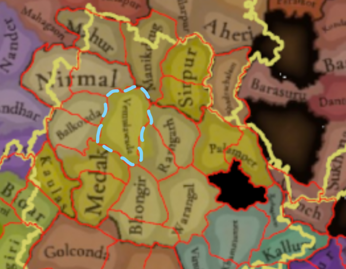
Andhradesha Rework

Locations:
1732683143125.png

1732683301755.png

1: Kovilkonda
2: Ghanpur
3: Panugallu
4: Amrabad
5: Devarakonda
6: Rachakonda
7: Nalgonda
8: Golconda
9: Kolanupaka
10: Bhongir
11: Medak
12: Induru (or Ramalayam may work as well)
13: Balkonda
14: Vemulawada
15: Elgandal
16: Ramagiri
17: Gandhari
18: Sirpur
19: Manikdrug
20: Mahur
21: Nirmal
22: Mhaisa
23: Bhallunke
24: Kaulas
25: Domakonda
26: Bidar
27: Hedimba
28: Yetagiri
29: Amangal
30: Raichur
31: Hatampura
32: Bhadrachalam
33: Palampet
34: Medaram
35: Orugallu
36: Khammammettu
37: Undrugonda
38: Macherla
39: Parlakhemundi
40: Kalingapatnam
41: Kalinganagara
42: Virakutam
43: Poram
44: Srikurmam
45: Vizianagaram
46: Jantarunuda
47: Simhachalam
48: Oddadi
49: Panchadarla
50: Elamanchili
51: Pithapuram
52: Jaddangi
53: Korukonda
54: Rajamahendravaram
55: Draksharamam
56: Palakollu
57: Prolavaram (modern-day Polavaram; notably named after and founded by Musunuri Prolaya Nayaka)
58: Vengi
59: Elluru
60: Machilipatnam
61: Vidarbhapuri
62: Vijayawada
63: Kondapalli
64: Nuzvid
65: Kalluru
66: Bhadrachalam
67: (Can't read what this location says, so just keep it as whatever it is I guess)
68: (Will go over later in a post dedicated to Gondwana)
69: Guntur
70: (Can't read what this location says, so just keep it as whatever it is I guess)
71: Kondavidu
72: Motupalli
73: Addanki
74: Vinukonda
75: Markapur
76: Prudulapuri
77: Ongole
78: Kandukuru
79: Khambham
80: Kavali
81: Udayagiri
82: Nellore
83: Gudur
84: (Can't read what this location says, so just keep it as whatever it is I guess)
85: Venkatagiri
86: Pulicat
87: Narayanavanam
88: Tirupati
89: Chittoor
90: Rachaveedu
91: Pottapi
92: Porumamilla
93: Siddavatam
94: Kadapa
95: Kadiri
96: Gandikota
97: Penukonda
98: Parigi
99: Ratnagiri
100: (Can't read what this location says, so just keep it as whatever it is I guess)
101: Gutti
102: Ahobalam
103: Nandyal
104: Srisailam
105: Kurnool
106: Adoni
107: Madanapalle (ancient name is Maryada Ramanna Puram, not sure when exactly the name of the settlement changed though)

Did my best to find period accurate location names, and to bring the modern territories of Andhra Pradesh and Telangana to a more respectable location density (though it is still far less dense than Europe unfortunately, I am having trouble finding any more settlements that for sure existed in the 14th century and as such cannot really add any more). I also made some changes to wastelands, and added some lakes.

Provinces:
1732833150393.png

1: Kalingandhra
2: Vengi Nadu
3: Pakanadu
4: Khammamet
5: Kammanadu
6: Sheshachalam (Southern Rayalaseema could also work, but I chose Sheshachalam since "Southern Rayalaseema" just seems awkward)
7: Renadu
8: Rayalaseema
9: Nellore
10: Palnadu
11: Golconda
12: Warangal
13: Ramagiri
14: Sirpur
15: Kalinga

Countries:
1732683375503.png

1: Kondavīdu (Prolaya Vema Reddi) [Member of Andhradesha IO]
2: Orugallu (Musunuri Kapaya Nayaka) [Leader of Andhradesha IO]
3: Anumagallu (Recherla Singama Nayaka) [Member of Andhradesha IO]
4: Kurnool (Chalukya Somadeva Aravidu) *
5: Narayanavanam (Sriranganatha Yadavaraya)
6: Ramagiri (Gurajala Muppabhupa Nayaka) [Member of Andhradesha IO]
7: Khammam (Confederacy of Chalukya Chiefs, led by various sons of Rudradeva)
8: Kamavarapukota (Eruva Bhaktiraja Choda)
9: Konamandala (Bhimavallabha II of the Haihayas)
10: Korukonda (Manchikonda Kunaya Nayaka) [Member of Andhradesha IO]
11: Pithapuram (Namayanayaka of the Koppulas)
12: Elamanchili ('Koppadeva' Rajanarayana of the Chalukyas) [Vassal of Trikalinga]
13: Panchadarla (Upendra I of the Haihayas) [Vassal of Trikalinga]
14: Oddadi (Jayanta II of the Matsyas) [Vassal of Trikalinga]
15: Trikalinga (Narasimha Deva III of the Purba Gangas)
16: Jantarunuda (Pratapa Gangaraju of the Gangas) [Vassal of Trikalinga]
17: Srikurmam (Purushottama of the Chalukyas) [Vassal of Trikalinga]
18: Virakutam (Purushottama of the Pallavas) [Vassal of Trikalinga]
19: Khemundi (?????? of the Purba Gangas) [Vassal of Trikalinga]

I have included both the states and their rulers in this section, with dynasty names italicized, and the status of the state in brackets.

* Notably, this Aravidu dynasty, which is a branch of the Chalukya dynasty, is the same dynasty as that of the final Emperors of Vijayanagara.

Resources:
1734109090534.png

1: Iron
2: Copper
3: Livestock
4: Fish
5: Saltpeter
6: Pearls
7: Fruit
8: Rice
9: Cotton
10: Sugar cane
11: Lumber
12: Clay
13: Elephants
14: Dyes
15: Sturdy Grains
16: Gems
17: Spices
18: Stone
19: Amber
20: Silk

Resources here are still a work in progress, and I'll see if I can comeback to it later to polish it, since a good portion of it is just taken from Tinto's given resource map and adjusted for the new location map, and another portion is just based off of modern data.

Vegetation:

The link provided contains a map of tree cover in 1930, which is the best guideline I could fine to base vegetation off of (no doubt there was probably a bit more tree cover in the 14th century though, its not like deforestation only started in the 20th century).

I also think there should be more farmland in the Krishna-Godavari Delta region, given the area's extensive history of being fertile agricultural lands.

Political Situation:
For the past few years, many ex-feudatories of the old Kakatiya dynasty have been united in a coalition to liberate Andhradesha from Tughlaq rule, under the leadership of Musunuri Kapaya Nayaka. As of 1337, this war against the Sultanate has been won by the rebel coalition, with them achieving independence and liberating Warangal from foreign occupation. After this victory, the various coalition members continued to acknowledge the Kapaya Nayaka as the rightful lord of Andhradesha, though beyond recognizing them as the successors to the Kakatiyas and the occasional intervention of the Musunuris in the politics of other Nayakas, they were very autonomous.

To represent this state of affairs, I'd suggest the implementation of an international organization, as well as with mechanics for the Recherlas of Anumagallu (or other Nayakas if the situation changes enough to warrant such after gamestart) to attempt to wrest Warangal from the Musunuris and usurp the title of "Lord of Andhradesha" from the Musunuris, as they attempted to do historically. The Recherlas should be scheduled to leave the international organization a few months after start date via event as a part of this (either that or have there be a claimant system like there is in the Ilkhanate where both the Recherlas and Musunuris are rival claimants), as soon after the liberation of Warangal the Recherlas would leave the Musunuri sphere of influence and begin opposing them, eventually joining hands with the Bahmanis to destroy them completely.

Mechanics for the Musunuris to centralize the IO should also exist, if they are able to grow in power and are able to ward off the Bahmanis (whom are founded shortly after start date).

Āndhradeśa IO
Lord of Andhradesha:
Orugallu (Musunuri Kapaya Nayaka)

Nayakas:
Ramagiri (Gurajala Muppabhupa Nayaka)
Korukonda (Manchikonda Kunaya Nayaka)
Kondavīdu (Prolaya Vema Reddi)
Anumagallu (Recherla Singama Nayaka)

Population Density
I have no sources to back this, but I feel as though you should redistribute some of the population from the jungled North of Telangana to the fertile and historically densely populated Krishna-Godavari Delta regions. I also feel as though some of the populations in the Rayalaseema Plateau to the Nandyal Valley, which is also an agriculturally fertile region, especially compared to the rest of Rayalaseema (which was historically comparatively sparsely populated during this period). The overall population of the entirety of modern-day Andhra Pradesh and Telangana is pretty spot on I believe, its just the distribution of that population that seems strange to me.
1732764217888.png


Culture
I found a map of historical inscriptions that I found interesting, and points towards there being a larger Tamil and Kannada presence on the fringes of Andhra Pradesh, until Telugu settlers were able to settle the fringes of Rayalaseema.
1732764523163.png

1732764540825.png

Source: (https://books.google.ca/books?id=HSfoCwAAQBAJ)

So perhaps this area could be made to be Kannada (striped areas signify majority, dotted borders signify minorities). The Kannada majority area should still have a large Telugu minority though.
1732764920319.png


Apart from the main Dravidian languages, there are also some tribal cultures I believe should be added:

Yerukala culture minority:
1732765066408.png

Kolami Culture minority:
1732765116806.png


I also believe Odia should be extended further South, given that much of the area that was the core-region of Kalinga. Admittedly, I am not certain on what the exact borders of the Odia culture should be, and I was perhaps overly conservative on the Odia presence in the region, but I have given my best estimate (not including tribal populations like the Sora, whom I haven't taken into account in this sketch):
1732765251386.png


Sources:
1732763093627.png

1732762427514.png

1732763028273.png
 

Attachments

  • 1732759875078.png
    1732759875078.png
    424,5 KB · Views: 0
Last edited:
  • 16Like
  • 4
  • 2Love
  • 1
Reactions:
Hello! In real life, minorities like the Siddi/Habshi established notable communities in Western India, particularly the Sindh, Hyderabad, and Gujarat, and political influence in many states. Shortly after the game's start time, these coalesced into minor states, one of which was known for defeating the Marathas and repelling their attempted conquest.

Likewise, South Asians likely had relationships with many Swahili cities, such as Shanga.


This is where my South Asia knowledge effectively ends :)

Will this be represented in the game?
 
Last edited:
  • 2Like
Reactions:
its 1337 not 2024
nouristan is a 19th century renaming after their mass conversion and that only concern a small area.

Kafir is the name , end of the story
With all due respect, I have a hard time believing the locals had no other names for this region, since that's a term associated with muslims/arabic. Is there no other term which can be used?
 
  • 3Like
  • 1
Reactions:
Hello @Pavía, I made an account just to write this comment, so I hope you respond, or any other developers for that matter.

What is the reason you have the Lakshadweep Islands as being culturally Dhivehi? I understand if that was just the case for the island of Minicoy, as it is still to this day Dhivehi speaking, but shouldn't the reset of the Lakshadweeps be speaking Jeseri a dialect of Malayalam?

Idk it just really bothered me as a Malayali
And glad you added my religion (Nasrani) thank youuuuu!!!
 
  • 1
Reactions:
I don't know if they are already, but traditionally tribal cultures like the Sora and Santali should probably be represented by tribesmen pops instead of regular peasant pops. I believe they often operated outside of traditional state power structures, so I believe a them being grouped pop-wise differently would be apt.
 
  • 2Like
Reactions:
I have overlayed a map of the British Raj with its princely states that I made on top of the location map, and there are a lot of states that are too small to be represented in the map.
View attachment 1735424734658.png
The projection difference does show pretty significantly above the Ganges, but everything below that lines up pretty well.
Most of these borders were established during the time frame of the game, so I think the locations should be able to accommodate these states.
I think this map also shows that a lot of the wastelands are too big, I think they should be there, however, they should be a lot thinner especially in the Western Ghats.
 
  • 2Like
Reactions:
I have overlayed a map of the British Raj with its princely states that I made on top of the location map, and there are a lot of states that are too small to be represented in the map.
View attachment 1236902
The projection difference does show pretty significantly above the Ganges, but everything below that lines up pretty well.
Most of these borders were established during the time frame of the game, so I think the locations should be able to accommodate these states.
I think this map also shows that a lot of the wastelands are too big, I think they should be there, however, they should be a lot thinner especially in the Western Ghats.
I'm not seeing any wastelands that cover the whole extent of a state or break it up into incommunicable pieces. So I don't think so.
 
  • 1
Reactions:
I'm not seeing any wastelands that cover the whole extent of a state or break it up into incommunicable pieces. So I don't think so.
I should have been more specific, but Bhor state has exclave in the Pune location due to the size of the wastelands.
Also a part of Hyderabad state is also and exclave due to Wastelands.
1735429853188.png

1735429877109.png

I do agree that this is not really a huge deal, but also from an aesthetic point of view, the wastelands look too wide for what are pretty narrow mountains.
 
  • 2Like
  • 1
Reactions:
I've finished my redo of Western Maharashtra, that I started in a previous post, mostly using British maps from the Raj era (which overlaps with the timeframe of the game). Although there are a lot of locations that I don't have specific evidence of existing in 1337, all of the locations do exist during the timeframe of the game, which I feel should make them eligible, even if they start with a low population.
1735547616913.png

I do think that this is a little too dense in some areas, but it's easier to remove locations than add them.
This is the map I based it off of:
1735547803230.png
 
  • 9Like
  • 1Love
  • 1
Reactions:
There needs to be some way to represent semi-autonomous governors of large empires, and the Delhi Sultanate and the later Mughal Empire are perfect examples of what I think needs to be represented. Both empires had governors that, after central authority weakened, declared independence, sometimes peacefully. For some examples, Jaunpur, Malwa, Bahmanis, and Gujarat for Delhi, and Bengal, Awadh, Hyderabad, and Carnatic for the Mughals.

I feel that a good way to do this is to have a building based country located in each of the capitals of these future states (if the governorship existed in 1337 of course, so no governor in Daulatabad), called a governor's mansion or something, and this building could project control around it, and any location that receives more control from this governor's mansion compared to the capital and is above a certain threshold would be considered a part of the governor's domain. This building should only be able to be built in a city location. All taxes from locations within their domain would go to the governor, and then the central government, depending on how loyal the governor is, or some other system, would get a cut of that. The governor should also be able to create their own armies, buildings and such. If a governor becomes disloyal, they stop paying taxes to their overlord, and if they see an opportunity, they will become declare independence and take their capital along with their domain, and their overlord could declare war in which case it would become like a rebellion, so all occupied locations will immediately flip to the overlord, and vice versa. If either side manages to capture the others' capital, the war immediately ends and the loser is full annexed. Proximity to overlord's capital should play a big role in determining how loyal a governor is.

If the governor becomes independent, the building should be destroyed, and when reconquered by their former overlord, they should have to rebuild the building, possibly in a different place as happened after the Lodis conquered Jaunpur, the new governor was located in Sasaram (the governor of which was Sher Shah Suri, who revolted during the Mughal conquest of Delhi, and founded the Sur empire). I say all this to show the historical precedent for a building/system like this existing.

The overlord should be able to choose the successor of the governor when they die. However, a disloyal governor should be able to choose their own successor. Only nobles/generals should be able to be appointed (or maybe even only generals, though pretty much all high ranking nobles in the Delhi Sultanate were also (not the best) generals). The governor building needs to be quite strong otherwise it would never be a good play to build it.

For the start of the game, I think that Delhi should have these buildings in Ahmedabad or Patan for Gujarat, Jaunpur for Jaunpur, Dhar for Malwa, Sirhind or Lahore (I forget which was the seat of the governor of Punjab at the time), and Multan for Multan.

I think this is a good compromise over having client states, which would look funky on the map, and not show a full empire. It is also better than predefined regions, because that detracts from the alt history. The Delhi governors, from what I can gather are going to have scripted independences, and that is fine, however, from the systems I've seen so far there does not appear to be any way model the system of governors that many of the Muslim empires in India after Delhi (and technically even the Hindu Marathas, though with their confederation after 1760s I think it would make sense to use client states instead because they were not appointed positions, but before that definitely).

I want to close this by saying that this is not something that is meant to be applicable to the whole world, and that a place like China that had complex bureaucracy and a high degree of centralization should not use this system. The reason it works for Indian empires is that many of them reached their height in a spree of quick conquests, and severely overextended their resources, requiring a large degree of delegation to govern their territories.

If there already exists a yet to be revealed system that models something similar, my praise to Paradox Tinto.
 
Last edited:
  • 4Like
  • 2Love
  • 1
Reactions:
I think this is slightly outside the scope of Tinto Maps, but I still wanted to bring this up since it is technically a map change.

There needs to be some way to represent semi-autonomous governors of large empires, and the Delhi Sultanate and the later Mughal Empire are perfect examples of what needs to be represented. Both empires had governors that, after central authority weakened, declared independence, sometimes peacefully. For some examples, Jaunpur, Bahmanis, and Gujarat for Delhi, and Bengal, Awadh, Hyderabad, and Carnatic for the Mughals.

I feel that a good way to do this is to have a building based country located in each of the capitals of these future states, called a governor's mansion or something, and this building could project control around it, and any location that receives more control from this governor's mansion compared to the capital and is above a certain threshold would be considered a part of the governor's domain. All taxes from locations within their domain would go to the governor, and then the central government, depending on how loyal the governor is, or some other system, would get a cut of that. The governor should also be able to create their own armies, buildings and such. If a governor becomes disloyal, they stop paying taxes to their overlord, and if they see an opportunity, they will become declare independence and take their capital along with their domain, and their overlord could declare war in which case it would become like a rebellion, so all occupied locations will immediately flip to the overlord, and vice versa. If either side manages to capture the others' capital, the war immediately ends and the loser is full annexed. Proximity to overlord's capital should play a big role in determining how loyal a governor is.

If the governor becomes independent, the building should be destroyed, and when reconquered by their former overlord, they should have to rebuild the building, possibly in a different place as happened after the Lodis conquered Jaunpur, the new governor was located in Sasaram (the governor of which was Sher Shah Suri, who revolted during the Mughal conquest of Delhi, and founded the Sur empire). I say all this to show the historical precedent for a building/system like this existing.

The overlord should be able to choose the successor of the governor when they die. However, a disloyal governor should be able to choose their own successor. Only nobles/generals should be able to be appointed (or maybe even only generals, though pretty much all high ranking nobles in the Delhi Sultanate were also (not the best) generals). The governor building needs to be quite strong otherwise it would never be a good play to build it.

For the start of the game, I think that Delhi should have these buildings in Ahmedabad or Patan for Gujarat, Jaunpur for Jaunpur, Dhar for Malwa, and Sirhind or Lahore (I forget which was the seat of the governor of Punjab at the time).

I think this is a good compromise over having client states, which would look funky on the map, and not show a full empire. It is also better than predefined regions, because that detracts from the alt history. The Delhi governors, from what I can gather are going to have scripted independences, and that is fine, however, from the systems I've seen so far there does not appear to be any way model the system of governors that many of the Muslim empires in India after Delhi (and technically even the Hindu Marathas, though with their confederation after 1760s I think it would make sense to use client states instead because they were not appointed positions).

If there already exists a yet to be revealed system that models all this, my praise to Paradox Tinto.

I completely agree that there needs to be a way to represent Delhi's governors. I like your suggestion, and it reminds me of a similar one I made as well (link: https://forum.paradoxplaza.com/forum/threads/the-governors-office.1720106/). I'm looking forward to the Tinto Flavor Talks when we see how exactly Paradox intends to model Delhi's collapse, and I hope they include your proposal as part of modeling it.
 
  • 3
  • 1Like
Reactions:
I completely agree that there needs to be a way to represent Delhi's governors. I like your suggestion, and it reminds me of a vaguely similar one I made as well (link: https://forum.paradoxplaza.com/forum/threads/the-governors-office.1720106/). I'm looking forward to the Tinto Flavor Talks when we see how exactly Paradox intends to model Delhi's collapse, and I hope they include your proposal as part of modeling it.
I definitely am looking forward to the Tinto Flavor for Delhi, but I just wanted to add that I hope that whatever mechanic they end up making is not restricted to just Delhi or any nation that forms/conquers Delhi, and that other future empires or even kingdoms can also use it, like the Marathas as I had mentioned, and even to an extent the Bahmanis, whose collapse could be seen as governors rising up, though I'd have to research that more.
 
  • 3
Reactions: