• We have updated our Community Code of Conduct. Please read through the new rules for the forum that are an integral part of Paradox Interactive’s User Agreement.

Tinto Maps #19 - 20th of September 2024 - India

Hello everyone, and welcome once again to another Tinto Maps! Today we will be taking a look at India! Yup, a whole subcontinent… Exciting!

Let me say a foreword before I start sharing with you some beautiful maps. Some of you may wonder why we decided to make the entire Indian subcontinent in just one DD, instead of spreading it a bit. There are two reasons for that. The first is the political situation: the Sultanate of Delhi is at its zenith, under Muhammad bin Tughlaq. You will soon see that it rules over more than half of the region, approximately; so splitting that polity into several DDs would have felt weird.

The other is that we felt that a more cohesive approach made sense in this region, as it’s sooo diverse compared to others, that the way we approached it, both for its setup and content, was from the generic to the particular; therefore, we think that it will also help us more when we tackle the review of the region. Speaking of that, don’t worry much about the time available to prepare suggestions; you may already know that we have a backlog of several regions, and therefore weeks, before we hit the Indian review, so you will have plenty of time to research and prepare them. In any case, as it’s a massive task (we know it firsthand), we’ll let you know a bit in advance when we plan to start the in-depth review of it, so you have time to wrap it up.

As a final say, I just want to mention that an old acquaintance of the community, @Trin Tragula , now Design Lead in CK3, helped us to map a big chunk of it. Thanks, mate! And now, maps!

Countries:
Countries.jpg

Colored Wastelands.png

As I just mentioned, the Sultanate of Delhi is at its zenith, under Muhammad bin Tughlaq, extending through the Indo-Gangetic Plain, including Bengal, and to the south, throughout the Deccan. There we have its toughest contender, Vijayanagar, a county that is a bulwark of Hinduism. Other important countries around it are Orissa and Sindh, but much smaller countries generally surround Delhi. You might wonder how it would be possible to stop Delhi from completely controlling the region, then. For this, two things are affecting its capability to achieve it. The first is the base game mechanics: ruling over so many different cultures and religions with low control will be hard. The second is a Situation that involves the Fall of the Sultanate; if Delhi wants to succeed, it will have to fight back against rebellions, which involves the potential independence of the Bengalese countries or newborn ones such as the Bahmanis, and the multiple Indian states around it, which are ready to take over it.

Dynasties:
Dynasties.jpg


Locations:
Locations.jpg

Locations 2.jpg

Locations 3.jpg

Locations 4.jpg
Yes, we are making some adjustments to the coloring of the mapmodes!

Provinces:
Provinces.jpg

Provinces 2.jpg

Provinces 3.jpg

Provinces 4.jpg

Areas:
Areas.jpg

The bug is still there, yes… The area that is to the southwest is Malabar.

Terrain:
Climate.jpg

Topography.jpg

Vegetation.jpg

Here we have a new type of topography: Atolls. We added it some months ago, as we worked on finishing the map of the Pacific Ocean, and it will be the last one added to the game.

Development:
Development.jpg

A new map mode is born! Here you have the development of India. The most developed place is Delhi, which is part of the fertile Gangetic Plain.

Harbors:
Harbors.jpg


Cultures:
Cultures.jpg

Cultures 2.jpg

Cultures 3.jpg
Not an entirely new map, but a glorious one. We chose it to be the one to present how the different cultures could be present in the game for a reason.

Religions:
Religions.jpg

Religions 2.jpg

Religions 3.jpg
India is the birthplace of numerous religions, and that needs to be reflected in the religious map. The main religion is Hinduism, but don’t be deceived by its homogeneous look, as it will be quite deep feature-wise. We also have Buddhism, which is at a low point, after some centuries of prosecutions. Mahayana is a majority in Sindh, although that's not completely exact, as an earlier form of Buddhism was practiced there; we’re also not 100% convinced about it being a majority, as some sources and accounts set the Islamization of the region to be completed under the Ghaznavids, in the 11th and 12th century, while others delay it until the 14th century - we followed the later approach, but we're very open to feedback in this specific matter. Another form of Buddhism is Theravada, which is the most practiced religion in Sailan. Some interesting minorities present in the region are Jains (yellow stripes), Nestorians (the pink stripe in Malabar, which portrays the ‘Saint Thomas Christians’), Jews (which have their own separate culture, ‘Kochini’), and several Animist confessions, of which we’ve already split Satsana Phi, the traditional religion of Tai people, and Sanamahism, the religion of Meitei people. Oh, although it’s not strictly part of the region, the light blue stripes to the north is Bön religion.

Raw Materials:
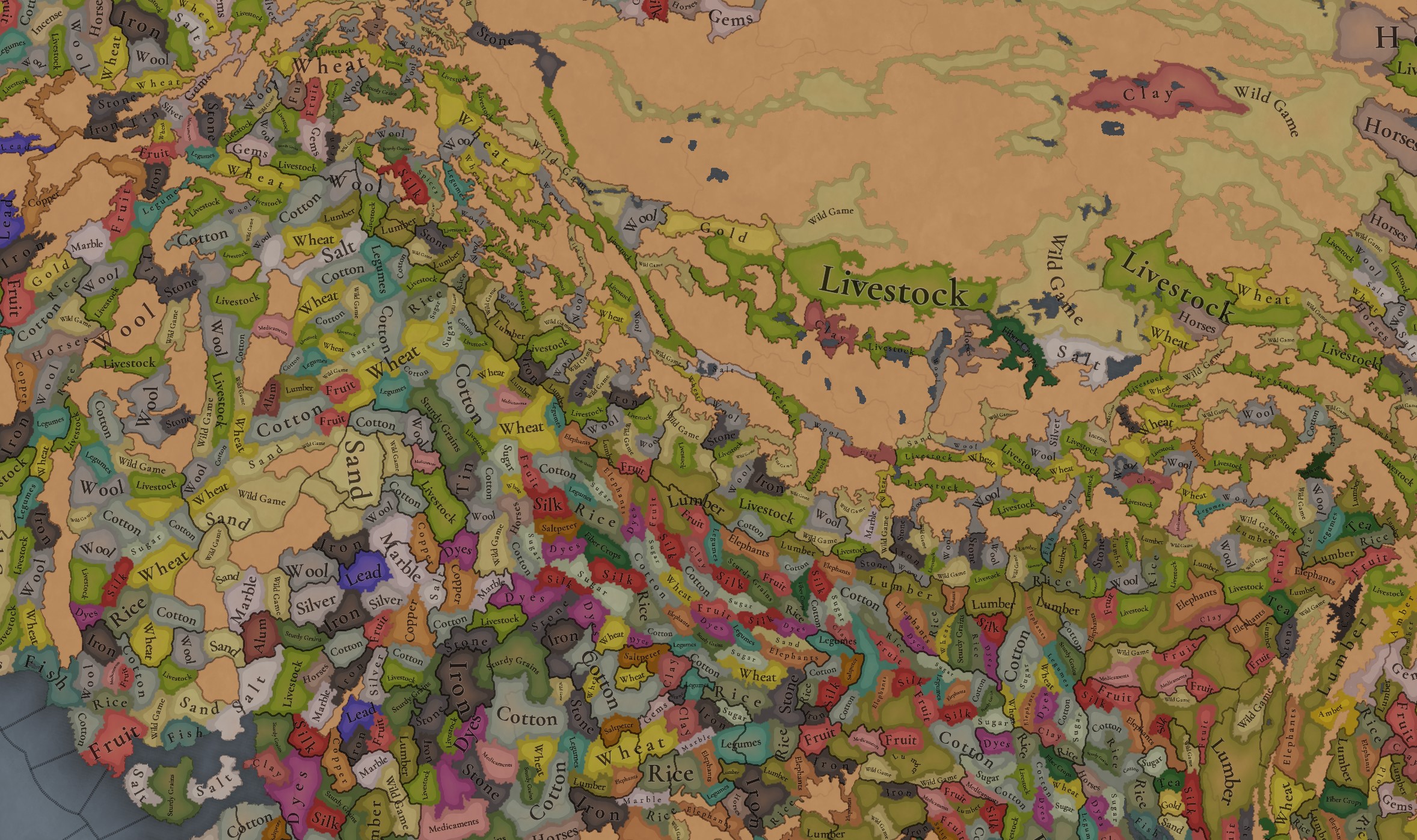
Raw Materials.jpg

Raw Materials 2.jpg

Raw Materials 3.jpg

Raw Materials 4.jpg
India was for some time in the period the wealthiest region of the world, one of the main reasons being that it’s incredibly rich in very different types of resources, including some of the expensive ones. That will make for a very interesting economic gameplay.

Markets:
Markets India.png

There are several market centers in India that we think portray well the situation in 1337: Kabul (yes, it’s in Afghanistan, but it’s one for the area of Kashmir), Delhi, Khambat, Calicut, Pulicat, Varanasi, and Chittagong.

Population:
Population.jpg

Population 2.jpg

Population 3.jpg

Population 4.jpg

Population 5.jpg

Population 10.jpg

Population 9.jpg

Population 6.jpg

Population 7.jpg

Population 8.jpg

India has a big population. To be precise, around 95M pops. Delhi is the second largest country in the world in population, with 41M pops, which makes it a behemoth, with very serious governance challenges. I’m also showing this week the progress we’re making with the coloring of the population mapmode; the stripes on several locations mark that they’re overpopulated, as they have more pops living on them than the pop capacity available (something that may be reviewed, as balancing very densely populated regions such as India or China is really challenging).

And that’s all for today! We hope you enjoyed this massive Tinto Maps. Next week we will be taking a look at the Steppe. Which one, you might wonder? Well, the one ruled by the Golden Horde, from Ukraine in the west to Mongolia in the east. Cheers!
 
  • 120Like
  • 98Love
  • 3
  • 3
  • 1
Reactions:
The simplification of Limbuwan as a single polity presents several critical issues. First, reducing the Kirats to one tag overlooks the unique governance structures and internal rivalries that defined them, erasing essential political and cultural nuances. While the Limbus were allied, representing them as a unified entity misrepresents the distinct autonomy of each kingdom. Additionally, the Wallo (near) and Majh (middle) Kirat regions must be distinguished from Limbuwan; when the Gorkha Kingdom launched its campaign, it first annexed Khambuwan before confronting the united forces of Pallo Kirat (Limbuwan), highlighting the separate identities and alliances within these areas. Moreover, the rise of a new king in Limbuwan typically signified the addition of an overlord rather than the removal of existing rulers. Even the Gorkha rulers maintained the kipat system and the subbas until the reign of King Mahendra.

The concept of relative importance is highly subjective; the significance of any kingdom or region can vary greatly based on context and perspective. Furthermore, the granularity of representation could be improved; countries like France and Italy have three to four times the location density, making it feasible to add a few more locations to accurately depict Limbuwan's complexity(india only has 1000 locations or so, so far). A more nuanced representation, such as a confederation model or recognition of individual kingdoms with shared diplomatic ties, would better reflect Limbuwan’s decentralized nature and historical significance.

If this approach is applied to Limbuwan, a similar methodology could extend to other regions in Nepal, including the latter: Chaubise and Baisse Rajya. Consequently, these areas might be reduced to mere tags, similar to representations in EU4. Moreover, distinguishing between separate kingdoms would simulate the power dynamics experienced during the Gorkha-Limbuwan War, enriching the historical and political context of the region.

Edit:Just wanted to add that Sikkim being a separate kingdom makes zero sense. It should be under limbuwan if following the perspective of same tag since the area till Teesta was part of limbuwan .
You're probably right, but I want to know more about IOs, decentralized nations, SOPs, and general game mechanics before I jump to the same conclusion. Nevertheless if it is split up into multiple tags, then the location density of Limbuwan would basically have to double. Speaking on Sikkim, yeah, it should be a part of Limbuwan (or at least most of it). I didn't include it in my proposal solely because I was mainly focusing on Limbuwan proper and the issues with the demographics as well as the locations.
 
Last edited:
Hey, @Pavía, could you please provide a feedback if doing nearly 40 kingdoms is even possible for Garhwal, because if it is not, I will move to Kumaon now, you know if it turns out I pour all that sweat into determining what was the raw resource of some small province of Garhwal-Tibet border only for it to turn out that the entire border area has been represented as just impassable terrain. (PS: You have done more density in northern Italy though)
Well if you consider the Italy-level density(maybe 294 total ) then it would be possible to go around 30 locations of so even for gharwal .But i am skeptical because they have highlighted clearly that not every feedback will add locations .Coupled with showing india in a single tinto map ,it shows where there priority is .Plus i have no idea what their criteria for determining the locations is since they have no answered in this regard. But you can give it a shot since there will be plenty of time because of backlogs of other nations.
 
  • 1
Reactions:
Well if you consider the Italy-level density(maybe 294 total ) then it would be possible to go around 30 locations of so even for gharwal .But i am skeptical because they have highlighted clearly that not every feedback will add locations .Coupled with showing india in a single tinto map ,it shows where there priority is .Plus i have no idea what their criteria for determining the locations is since they have no answered in this regard. But you can give it a shot since there will be plenty of time because of backlogs of other nations.
I think the only reason they showed India in a single Tinto map is because they didn’t want to have to cut the Delhi Sultanate into two pieces. I’m sure they want to represent India accurately as well, and I don’t think there was any bad intent (though I do wish they posted more zoomed in maps so the country names were actually readable).
 
  • 2
  • 1Like
Reactions:
I think the only reason they showed India in a single Tinto map is because they didn’t want to have to cut the Delhi Sultanate into two pieces. I’m sure they want to represent India accurately as well, and I don’t think there was any bad intent (though I do wish they posted more zoomed in maps so the country names were actually readable).
I can barely read name of some locations .Heck i cant read the name of some countries .so if they wanted proper feeback they would have at least provided more clear detailed maps .Its not that hard. Also side note they had no problem breaking hre .First they showed whole hre in the Germany and then Italy in a separate tinto maps. See the maps of russia and steppes .You see russia is already visible there in the maps of steppes .In the first place they could easily do both in the same tinto maps of russia but no! they did it into 2 go.They could follow similar approach in india (see the map i provided of india with possible tinto maps).But no they were already ready with Preemptive rationalization.I could argue with more points but i guess you dont like to here the truth .It is only in the recents years that india has gotten some love in paradox games .But i dont want to cry over a spilled mik.

1727802828872.png

fig:the Steppes

1727803031034.png

fig:russia


1727801823972.png
 
  • 2
Reactions:
The first is the political situation: the Sultanate of Delhi is at its zenith, under Muhammad bin Tughlaq. You will soon see that it rules over more than half of the region, approximately; so splitting that polity into several DDs would have felt weird.
No one is talking about splitting Delhi .You could have just split india .India is not a single polity.You could have done it like you did with eastern europe.See like below.So i would have appreciated if you would have simply stated we decided to just do india one go rather than Defensive posturing.
I can barely read name of some locations .Heck i cant read the name of some countries .so if they wanted proper feeback they would have at least provided more clear detailed maps .Its not that hard. Also side note they had no problem breaking hre .First they showed whole hre in the Germany and then Italy in a separate tinto maps. See the maps of russia and steppes .You see russia is already visible there in the maps of steppes .In the first place they could easily do both in the same tinto maps of russia but no! they did it into 2 go.They could follow similar approach in india (see the map i provided of india with possible tinto maps).But no they were already ready with Preemptive rationalization.I could argue with more points but i guess you dont like to here the truth .It is only in the recents years that india has gotten some love in paradox games .But i dont want to cry over a spilled mik.

View attachment 1196230
fig:the Steppes

View attachment 1196234
fig:russia


View attachment 1196225


The other is that we felt that a more cohesive approach made sense in this region, as it’s sooo diverse compared to others
Ok its diverse so lets just compress it into a single map. Makes sense .
 

Attachments

  • 1727804016422.png
    1727804016422.png
    1,9 MB · Views: 0
  • 1
Reactions:
Getting pissy over the fact that they made India a single TM isn't helping matters, frankly. Also, Pavia's on vacation for several weeks so it's not even a complaint that's going to get read any time soon by the intended recipient, let alone addressed (and it certainly won't be addressed at this point).

I agree about the zoom level on the location maps that we were given, though.
 
  • 5Like
Reactions:
Getting pissy over the fact that they made India a single TM isn't helping matters, frankly. Also, Pavia's on vacation for several weeks so it's not even a complaint that's going to get read any time soon by the intended recipient, let alone addressed (and it certainly won't be addressed at this point).

I agree about the zoom level on the location maps that we were given, though.
Well, I’m definitely upset that India was made into a single map. But what frustrates me even more is the reasoning behind it.
So i would have appreciated if you would have simply stated we decided to just do india one go rather than Defensive posturing
Still, I commented not because of this—the die is cast—but so they can take this into consideration for future Tinto maps.

Edit:Thank you for invalidating my opinion by pointing i was pissy .
 
  • 1Like
Reactions:
I have a few changes to suggest for Western Maharashtra, mostly in Konkan region. These are some of the locations names and borders that I would change as well as a few new locations. I am also hoping that Salsette Island will be represented as an actual island, or at least surrounded by rivers on all sides, as that would be historical. It should definitely be its own location considering how important it was historically. I do think that central Maharashtra does not have enough locations considering how densely populated the entire state is compared to Europe, but I don't know enough to suggest changes.

Edit:
A more detailed redoing of the Konkan region
(Deleted the map here)
Edit #2:
An even more detailed redoing of Western Maharashtra. I am going to continue expanding eastward.
1735435395217.png

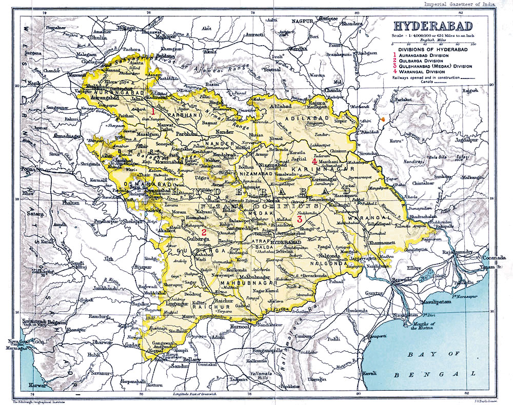
I have a few extra maps that I don't have the time to copy over to this map, but I think those will also be useful. They are both from the Imperial Gazetteer of India.
Bombay_Prov_south_1909.jpg
Hyderabad_state_from_the_Imperial_Gazetteer_of_India,_1909.jpg


I don't think that all of the towns/cities on these maps should be added, but if a majority of them are, I think that would be more than enough to make playing in the region feel detailed. This is my favorite area to play in, but in every Paradox title it has a low location density despite being well developed in the modern day and being very densely populated. It makes me a little sad, but hopefully I can play a part in changing that in Project Caesar.

Edit: I'm going to attach the rest of the Imperial Gazetteer of India maps as well since they should be incorporated as well.
Baluchistan (I know that most of it is not in this map, but some of it is):
1728374262730.png

Baroda:
1728374346182.png

Sindh:
1728374377480.png

Central India:
1728374428536.png

Central Provinces and Berar:
1728374456194.png

East Bengal and Assam:
1728374522825.png

Madras (North):
1728374545218.png

South India:
1728374563959.png

Kashmir:
1728374590823.png

Punjab:
1728374604394.png

Rajputana:
1728374625686.png

United Provinces:
1728374640495.png
 

Attachments

  • TintoMapsChanges.png
    TintoMapsChanges.png
    471,2 KB · Views: 0
  • 1729311394881.png
    1729311394881.png
    4,4 KB · Views: 0
  • 1729311425083.png
    1729311425083.png
    4,4 KB · Views: 0
  • 1729311510384.png
    1729311510384.png
    473,6 KB · Views: 0
Last edited:
  • 8Like
  • 1Love
  • 1
Reactions:
Hello everyone, and welcome once again to another Tinto Maps! Today we will be taking a look at India! Yup, a whole subcontinent… Exciting!

Let me say a foreword before I start sharing with you some beautiful maps. Some of you may wonder why we decided to make the entire Indian subcontinent in just one DD, instead of spreading it a bit. There are two reasons for that. The first is the political situation: the Sultanate of Delhi is at its zenith, under Muhammad bin Tughlaq. You will soon see that it rules over more than half of the region, approximately; so splitting that polity into several DDs would have felt weird.

The other is that we felt that a more cohesive approach made sense in this region, as it’s sooo diverse compared to others, that the way we approached it, both for its setup and content, was from the generic to the particular; therefore, we think that it will also help us more when we tackle the review of the region. Speaking of that, don’t worry much about the time available to prepare suggestions; you may already know that we have a backlog of several regions, and therefore weeks, before we hit the Indian review, so you will have plenty of time to research and prepare them. In any case, as it’s a massive task (we know it firsthand), we’ll let you know a bit in advance when we plan to start the in-depth review of it, so you have time to wrap it up.

As a final say, I just want to mention that an old acquaintance of the community, @Trin Tragula , now Design Lead in CK3, helped us to map a big chunk of it. Thanks, mate! And now, maps!

Countries:
View attachment 1189937
View attachment 1190039
As I just mentioned, the Sultanate of Delhi is at its zenith, under Muhammad bin Tughlaq, extending through the Indo-Gangetic Plain, including Bengal, and to the south, throughout the Deccan. There we have its toughest contender, Vijayanagar, a county that is a bulwark of Hinduism. Other important countries around it are Orissa and Sindh, but much smaller countries generally surround Delhi. You might wonder how it would be possible to stop Delhi from completely controlling the region, then. For this, two things are affecting its capability to achieve it. The first is the base game mechanics: ruling over so many different cultures and religions with low control will be hard. The second is a Situation that involves the Fall of the Sultanate; if Delhi wants to succeed, it will have to fight back against rebellions, which involves the potential independence of the Bengalese countries or newborn ones such as the Bahmanis, and the multiple Indian states around it, which are ready to take over it.

Dynasties:
View attachment 1189938

Locations:
View attachment 1189939
Yes, we are making some adjustments to the coloring of the mapmodes!

Provinces:
View attachment 1189943

Areas:
View attachment 1189947
The bug is still there, yes… The area that is to the southwest is Malabar.

Terrain:
View attachment 1189948
View attachment 1189949
View attachment 1189950
Here we have a new type of topography: Atolls. We added it some months ago, as we worked on finishing the map of the Pacific Ocean, and it will be the last one added to the game.

Development:
View attachment 1189951
A new map mode is born! Here you have the development of India. The most developed place is Delhi, which is part of the fertile Gangetic Plain.

Harbors:
View attachment 1189952

Cultures:
View attachment 1189954
Not an entirely new map, but a glorious one. We chose it to be the one to present how the different cultures could be present in the game for a reason.

Religions:
View attachment 1189956
India is the birthplace of numerous religions, and that needs to be reflected in the religious map. The main religion is Hinduism, but don’t be deceived by its homogeneous look, as it will be quite deep feature-wise. We also have Buddhism, which is at a low point, after some centuries of prosecutions. Mahayana is a majority in Sindh, although that's not completely exact, as an earlier form of Buddhism was practiced there; we’re also not 100% convinced about it being a majority, as some sources and accounts set the Islamization of the region to be completed under the Ghaznavids, in the 11th and 12th century, while others delay it until the 14th century - we followed the later approach, but we're very open to feedback in this specific matter. Another form of Buddhism is Theravada, which is the most practiced religion in Sailan. Some interesting minorities present in the region are Jains (yellow stripes), Nestorians (the pink stripe in Malabar, which portrays the ‘Saint Thomas Christians’), Jews (which have their own separate culture, ‘Kochini’), and several Animist confessions, of which we’ve already split Satsana Phi, the traditional religion of Tai people, and Sanamahism, the religion of Meitei people. Oh, although it’s not strictly part of the region, the light blue stripes to the north is Bön religion.

Raw Materials:
View attachment 1189959
India was for some time in the period the wealthiest region of the world, one of the main reasons being that it’s incredibly rich in very different types of resources, including some of the expensive ones. That will make for a very interesting economic gameplay.

Markets:
View attachment 1190014
There are several market centers in India that we think portray well the situation in 1337: Kabul (yes, it’s in Afghanistan, but it’s one for the area of Kashmir), Delhi, Khambat, Calicut, Pulicat, Varanasi, and Chittagong.

Population:
View attachment 1189963

India has a big population. To be precise, around 95M pops. Delhi is the second largest country in the world in population, with 41M pops, which makes it a behemoth, with very serious governance challenges. I’m also showing this week the progress we’re making with the coloring of the population mapmode; the stripes on several locations mark that they’re overpopulated, as they have more pops living on them than the pop capacity available (something that may be reviewed, as balancing very densely populated regions such as India or China is really challenging).

And that’s all for today! We hope you enjoyed this massive Tinto Maps. Next week we will be taking a look at the Steppe. Which one, you might wonder? Well, the one ruled by the Golden Horde, from Ukraine in the west to Mongolia in the east. Cheers!
1728379904046.png

Here is also some strange lack of culture colour diversity. a lot of Red, a lot of Cyan
 
  • 1
Reactions:
Will there be a special mechanic to model the failure/unwillingness of the Muslim countries to convert India to Islam?
India wasn't converted to Islam not because of unwillingness of the Muslim states although the failure part is true but by the sheer resistance put up my Hindu societies on every single level. So I guess the Hindus should get the special mechanic lol even the British were unsuccessful in converting. But both religions successfully converted Africa.
 
Now that we're getting into the spice trade areas, I'll mention that there should probably be a distinction between different types of spices. Certain types were only available in tropical areas, and should be differentiated from those closer to Europe-- especially since we have like 4 types of grain, and dates (the fruit) are their own good lol. Just feels weird we have so much granularity with some goods, and then we get hit with a unitary SPICE rgo.
Not sure how they could be subdivided, 'sweet' vs 'hot' spices? 'tropical' spices? or genuinely just cinnamon/cloves being on their own

Also... elephants here but not in Africa?
Only the Asian Elephant was tamed/domesticated hence a trade good. African elephants were never tamed instead purely used for ivory and other elephant products.
 
I cannot stress this enough but please incorporate the Hebbale Inscription of the Hoysalas into the game. Their strife against the Delhi Sultanate needs to be accounted for. Also a few locations and provinces in modern day Karnataka are misplaced (Malnad) or wrongly named (Karnakassala.....never heard of that word until on here and I'm from that region Karu Nadu would be preferable).
 
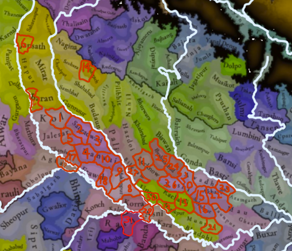
Uttar Pradesh:


New Location Map:
1728523844782.png

1: Jalali
2: Patiyali
3: Shamsabad
4: Bhogaon
5: Sakit
6: Kandhla
8: Jajmau
9: Makanpur
10: Kannauj
11: Sandila
12: Dalmau
13: Jais
14: Rampur
15: Sultanpur
16: Belha
17: Rapri
18: Auraiya
19: Samugarh
20: Radauli
21: Machhalishahr
22: Rasulpur
23: Kichhocha
24: Ibrahimabad
25: Barabanki
26: Thulendi
27: Bangarmau
28: Bisrakh
29: Bhitaura
30: Sangrampur
31: Maudaha

I feel like adding this many locations is necessary to do the region justice. The Doab, Awadh, and the surrounding regions, have always been one of the main centers of Indian civilization, and is one of the most economically potent regions in the entire world, with a huge diversity of resources, and behemoth populations. Adding more locations would allow for resources to be more accurately displayed, would help alleviate issues with population capacity, and is necessary to represent some of the granularity in political borders that will arise after the fall of the Delhi Sultanate, and the likely eventual fall of Jaunpur after it.

Also, I'd like to thank @Ekyman for his map of rivers and modern political borders overlayed on the location map. Suggesting new locations would be much, much more difficult without that overlay.


Name Changes:

Locations:
Kol -> Koil
Mirat -> Meerut (or Mēraṭh if you want to be phonetic)
Korra -> Kora
Shahjahanpur -> Jalalabad
Pilibhit -> Kabar (modern-day Shergarh)
Bareilly -> Senthal (modern-day Sethal)
Shahabad -> Aonla
Firuzabad (What is Firuzabad??? I can't find any mentions of a settlement named Firuzabad here) -> Lakhimpur (though Lakhimpur might be just barely outside of the borders of the location, so I would move the border slightly further West so that it's included)

Areas:
Rohilkhand -> Katehar


Resources:
I'll go more into depth on what resources should be in what specific locations in the future (if I end up having the time), but for now I'll link one of my older posts from another thread which contains some information on certain raw goods. Currently, Jaunpur in particular stands out to me, and it should be changed from legumes to silk.
Took some time to document the trade goods in the lands of the Jaunpur Sultanate and its periphery. I might refine it in the future and do some more research on rural areas:

Cities:
Bihar Sharif: Paper
Zafrabad: Paper, carpets
Arwal: Paper
Jaunpur: Silk, muslin, woolen carpets, jasmine oil
Kannauj: Silk, muslin, calico, brocade, woolen carpets, jasmine oil
Fatehpur: Carpets
Mirzapur: Carpets
Bhadohi: Carpets
Awadh (Ayodhya): Cloth
Kara: Fine fabrics
Manikpur: Fine fabrics
Benares: Muslin, calico, silk, brocade, textiles, brassware, metal-works
Delhi: Luxury textiles
Etawah: Jasmine oil

Rural Regions:
Bahraich region: Rice
Awadh region: Rice
Jaunpur region: Rice
Kara & Manikpur regions: Sugar cane, wheat, and rice
Kannauj region: Sugar
The Sultanate as a whole: Cotton, wheat, rice, barley, pulses, millet, sugar cane, indigo, hemp, fruits

Source:


Political:
Tughlaq rule over the Bareilly and Khairabad regions is extremely lose (often just a fort or two in the region, and sometimes not even that), and the locals mostly conducted their own affairs under the rule of the Katheriya Rajputs. I suggest you make the Katheriya a society of pops, with them controlling the vast majority of the Hindu population in the Bareilly and Khairabad provinces, with the Sultanate only controlling 500 or so of the population (mostly just the local garrisons of isolated forts). Alternatively, you can simply represent Katehar as an independent state under the Katheriya dynasty with Delhi only owning the major cities like Budaun. I'm not really sure how the mechanics of SOPs work in practice, so I'm not really sure what would fit the Katheriyas and their long-term guerrilla war against the Sultans better.
1728528867826.png


Terrain:
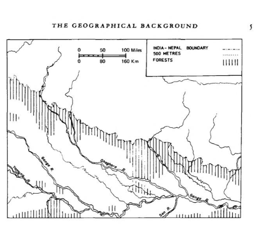
I'll let @Sulphurologist take care of this, as I'm sure he's more knowledgeable than me. But there should definitely be more woods along the modern-day Indo-Nepali border (Thanks to @PerhapsItsChondoLal for finding this map of the tree cover in 1600):

1728528039830.png


I also believe there should be more farmland along the course of the Ganges (Bihar and Bengal in particular seem lacking, though that's outside of the scope of this post).
 
Last edited:
  • 9
  • 6Like
  • 4Love
  • 1
Reactions:
Uttar Pradesh:


New Location Map:
View attachment 1199960
1: Jalali
2: Patiyali
3: Shamsabad
4: Bhogaon
5: Sakit
6: Kandhla
8: Jajmau
9: Makanpur
10: Kannauj
11: Sandila
12: Dalmau
13: Jais
14: Rampur
15: Sultanpur
16: Belha
17: Rapri
18: Auraiya
19: Samugarh
20: Radauli
21: Machhalishahr
22: Rasulpur
23: Kichhocha
24: Ibrahimabad
25: Barabanki
26: Thulendi
27: Bangarmau
28: Bisrakh
29: Bhitaura
30: Sangrampur
31: Maudaha

I feel like adding this many locations is necessary to do the region justice. The Doab, Awadh, and the surrounding regions, have always been one of the main centers of Indian civilization, and is one of the most economically potent regions in the entire world, with a huge diversity of resources, and behemoth populations. Adding more locations would allow for resources to be more accurately displayed, would help alleviate issues with population capacity, and is necessary to represent some of the granularity in political borders that will arise after the fall of the Delhi Sultanate, and the likely eventual fall of Jaunpur after it.

Also, I'd like to thank @Ekyman for his map of rivers and modern political borders overlayed on the location map. Suggesting new locations would be much, much more difficult without that overlay.


Name Changes:
Kol -> Koil
Mirat -> Meerut
Korra -> Kora
Shahjahanpur -> Jalalabad
Pilibhit -> Kabar (modern-day Shergarh)
Bareilly -> Ahikshetra (best alternative could find)
Shahabad -> Aonla
Firuzabad (What is Firuzabad??? I can't find any mentions of a settlement named Firuzabad here) -> Lakhimpur (though Lakhimpur might be just barely outside of the borders of the location, so I would move the border slightly further West so that it's included)


Resources:
I'll go more into depth on what resources should be in what specific locations in the future (if I end up having the time), but for now I'll link one of my older posts from another thread which contains some information on certain raw goods. Currently, Jaunpur in particular stands out to me, and it should be changed from legumes to silk.


Political:
Tughlaq rule over the Bareilly and Khairabad regions is extremely lose (often just a fort or two in the region, and sometimes not even that), and the locals mostly conducted their own affairs under the rule of the Katheriya Rajputs. I suggest you make the Katheriya a society of pops, with them controlling the vast majority of the Hindu population in the Bareilly and Khairabad provinces, with the Sultanate only controlling 500 or so of the population (mostly just the local garrisons of isolated forts). Alternatively, you can simply represent Katehar as an independent state under the Katheriya dynasty (I would much prefer the later for simplicity's sake, and because Katehar was by no means uncivilized [they were on a similar level of development to Gondwana, which itself is displayed as a series of settled states, so it would be inconsistent to represent Katehar as a SOP. The only reason I suggested making them a SOP potentially is because I'm not sure how else you'd represent Delhi owning a fort or two in the location {perhaps through foreign buildings, kind of like the mission or trade office, but I'm not sure how you guys are planning on doing those}], but both work to represent the Katheriya Rajput's influence over the region).
View attachment 1199972


Terrain:
I'll let @Sulphurologist take care of this, as I'm sure he's more knowledgeable than me. But there should definitely be more woods along the modern-day Indo-Nepali border (Thanks to @PerhapsItsChondoLal for finding this map of the tree cover in 1600):

View attachment 1199970

I also believe there should be more farmland along the course of the Ganges (Bihar and Bengal in particular seem lacking, though that's outside of the scope of this post).
I'm slowly but surely making my way through the past 4 dev diaries after my vacation, topography will follow soon™ :)
 
  • 4Like
Reactions: