• We have updated our Community Code of Conduct. Please read through the new rules for the forum that are an integral part of Paradox Interactive’s User Agreement.

Tinto Maps #20 - 27th of September 2024 - The Steppes

Hello, and welcome one more week to the weekly encounter for map lovers! This week it’s also directed at horse lovers because we will be looking at the Eurasian Steppes, plus the Urals! So let’s start with the maps without further ado.

Countries:
Countries.jpg

Colored Wastelands.jpg

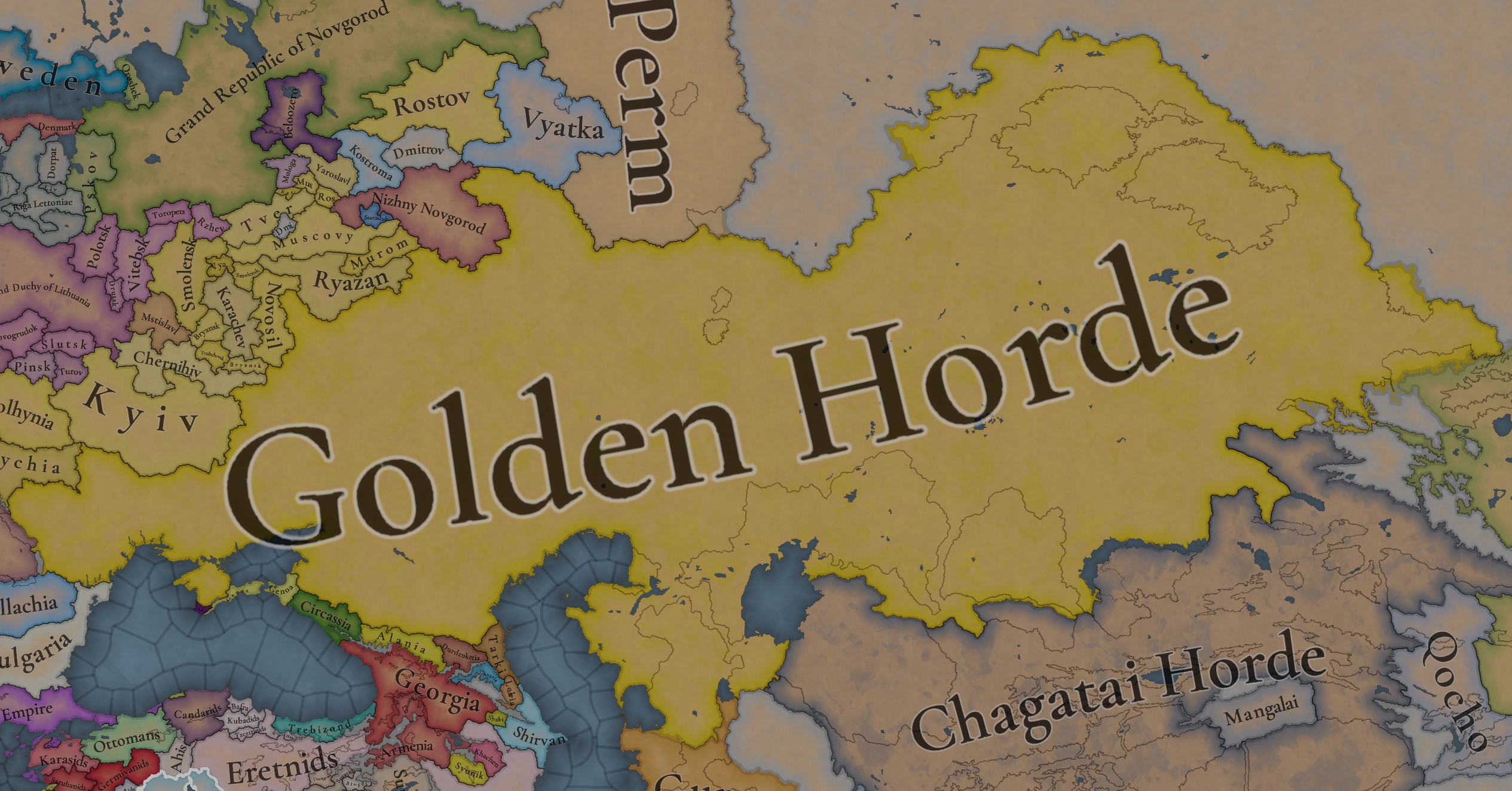
A glorious, Golden Horde! It is at its power peak, under the reign of Uzbeg Khan, so it's a much more menacing presence for its neighbors. However, it has its some internal issues that need to be managed, as you’ll notice in some of the maps, and in the future when we talk about the content for Hordes. The Golden Horde also heads its own IO, the Tatar Yoke, as shown in a previous Tinto Maps:

Tatar Yoke.jpg

We have already corrected the Ruthenian countries that are under the Horde’s Yoke, although we still have to correct the Russian principalities, which will be done in the corresponding Tinto Maps review. We’re also aware that we need to improve a bit the coloring of the IO, to mark not only the Golden Horde as the overlord of these countries, but also that Muscovy holds the title of the Grand Principality of Vladimir, which makes it the ‘enforcer’ of the Yoke. These fixes are also planned to be done in a few weeks.

Societies of Pops:
Societies of Pops.jpg

Societies of Pops 2.jpg .jpg

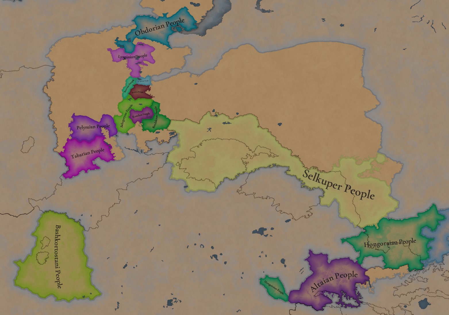
A bit up to the north, we have some Societies of Pops! This means that the territory of Western Siberia won’t be empty land, but will be populated by these people, which can be interacted with.

BTW, I’m not showing this week a dynasty map because, well, only the Borgijin dynasty rules over the lands of the Golden Horde, of course!


Locations:
Locations.jpg

Locations Western Siberia.jpg

Locations 3.jpg

Locations 4.jpg

Locations 5.jpg

Tons of locations today… You might notice that the density location is in a progression from west to east, from the most densely settled areas to the less settled ones. You may also notice that we’ve followed a design of ‘settler corridors’ in Western Siberia, setting those parts of the land that were habitable, usually on river valleys.

Provinces:
Provinces.jpg

Provinces 2.jpg


Areas:
Areas.jpg


Terrain:
Climate.jpg

Topography.jpg

Vegetation.jpg

The terrain is interesting here, as there are two main ecological areas. The first is the Steppes, Flatlands with Sparse and Grasslands vegetation, with either Cold Arid or Continental climates. And then we have the Siberian Arctics Forests, which are completely different, of course. On a note, the Urals were set as Hills, as they’re a quite settleable area, but we’ll probably make a review with your feedback, and add some mountains there.

Development:
Development.jpg

The whole region is not very developed, you might notice the difference with India, from last week’s Tinto Maps.

Harbors:
Harbors.jpg

There are some harbors in the Steppe region… In the Black Sea and Caspian Sea, of course! As usual, we’re open to feedback on this matter.

Cultures:
Cultures.jpg

Plenty of cultures! One note: Although we planned to work on the religious and cultural minorities of the region during the summer, we ended up not having enough time to add them. So what we’ll be doing today is showing the rough outline of ‘cultural spheres’, and then we’ll add the minorities during the review of the region. In that sense, feedback is very well received.

With that said the only note that needs to be made in terms of the cultural design is that we divided the Tatar cultural group into some differentiated regional cultures, being Crimean, Mishary, Kazani, and Astrakhani. We’re also aware that some of the cultures, as Mari and Chuvash, might be a bit displaced, as noted in the Russian Tinto Maps, so we’ll review and correct that with your feedback.


Religions:
Religions.jpg

Regarding Religions, the matter is a bit worse, as the big Sunni blob is just because the main religion of the Golden Horde is Islam, after the conversion of Uzbeg Khan, but that’s obviously incorrect. Also, as we have been able to forecast development time on how Pagan divisions will be during this autumn, we will make a comprehensive review of the region as well, to get a good distribution of ‘Shamanist’ Paganism, Tengrism, and Sunni Islam.

Raw Materials:
Raw Materials.jpg

Raw Materials 2.jpg

Raw Materials 3.jpg

Regarding the raw materials, the Steppes have plenty of Livestock and Horses, quite logically, although there are regions with some other goods. And up to the north, the main materials are Lumber and Fur. Apart from that, I want to mention the mineral hub in the Ural Mountains, with plenty of Copper, Iron, Gold, Lead, and Coal. That makes it a very mid and late-game interesting spot, and playing as Muscovy/Russia, I’ll tell you that you definitely want to expand into that region, as it will fulfill some of your material needs by that time.

Markets:
Markets.jpg

Markets! Big region, with lots of markets, although you may noticed that we changed the coloring of the locations that have 0% market access, which is the case in several areas. In any case, the market centers are Kaffa, Astrakhan, Saray-Jük, Kunya Urgench, Samarkand, Almaty, and Chimgi Tura. BTW, these names are much easier to notice in the game’s UI, as they’re beside the market centers:

Markets 2.jpg


Population:
Population.jpg

This week we’re showing only the country population mapmode, as there are some location numbers here and there which are failing, due to the already known issue with our pop editor (and which are on the way to be fixed). In any case, the whole population of the region is around 6.5-7M, of which around 6.3M are part of the Golden Horde. As I said, it’s a menacing country…

And that’s all for today! This is going to be my last Tinto Maps in a while, as I’ll be on vacation for 3 weeks during October (you might have noticed that I didn’t have any during summer), so one of the Content Designers in the team, @Roger Corominas , will step in and be in charge of the next 4 Tinto Maps. It’s in good hands, as Roger is an Experienced CD, who has been working and focused on Project Caesar for more than 3 years, at this point (this is why you might not know him from EU4, as other CDs in our team). In any case, he will be starting with the regions of Xinjiang, mostly ruled by the Chagatai Khanate, and Tibet.

I’ll keep reading and answering you during next week, and then I’ll be back in a month from now. See you!
 
  • 145Like
  • 48Love
  • 4
  • 3
  • 1Haha
Reactions:
The more I look into it, the more I believe it is waaay too much.

Can you provide for every ulus/horde some works that say they had independent tax collection, independent army, independent administration?

Why it is not just strong nobles? If we apply same approach to any other nation we will get HRE like maps everywhere, because nations were never unitary at that time.

Because it just looks like putting every mention of something called remotely ulus to the map.

Like there are two uluses named Siban, are we even sure it is not just a single one with undetermined history? (For example some say one thing others differ)

Personally, I kinda burned out of googling every name from the map to find even a fraction of information, and just feel like Golden Horde should be one tag with a strong nobles estate, and unique mechanics for all hordes representing blue/white division.

For example election mechanic: have 2-3 noble families(instead of one) that divide your realm into parts(white, blue and for GH also Shiban), and have a player elect the next ruler from them, pissing of the other branch and having some unrest. And if you lose to the unrest you fragment to two or more nations.

The division itself can be SoP or building based (like Yurt), that will with time change its dislocation slightly. At the end of the day, hordes are nomads, they migrate from place to place, change their locations and the borders between them. Uzbek tribes started with in Tumen river basin in Siberia, bun ended in Uzbekistan. Any depiction of borders relevant in 13 century will become irrelevant in few years of gameplay.

Not everything should be drawn on the map. I believe abstraction is also a solution.

I have already cited the source (Sbornik_Kurgan2). It said that the Blue Horde had started issuing its own coins with the face of the ruler of the Blue Horde. It is believed that Mubarak Khoja Khan tried to become independent. But we do not know exactly when, various sources say that Uzbek Khan sent his son Tinibek against him and they fought with their troops in the territory of "Desht-i-Kipchak" (this is exactly the ulus that I mistakenly called shibana ulus, cyanic) in 1320, or 1340-1342, or 1345-1352. This means that the hordes had their own rulers, their own armies, and a tribute collection system.

There are two Shiban ulus, because before Uzbek Khan's reform, it really was one ulus. The source mentions that Uzbek Khan took away the ulus from the Shibanids, but it is unknown which one. But for some reason, the researchers write that this territory in the center did not belong to the Shiban ulus. From this, I concluded that it was this ulus that Uzbek Khan took away from the Shibanids.

Yes, there were three great families. The heirs of Batu, Orda-Ezhen and Shiban. It is because of this that the problem of ambiguous understanding of hordes has appeared.

The hordes stopped changing their borders after Uzbek Khan's reforms. However, the rulers could overthrow each other and move from one ulus to another. In a sense, this can be called nomadism, because a significant part of the population followed their ruler.

Uzbeks are not a separate people, but Tatars, who revered their former ruler Uzbek Khan. The Uzbek Khanate and Uzbekistan are two different states with different peoples. But they are called almost the same, because both received their statehood under Uzbek Khan. The first state is the very ulus that Uzbek Khan took away from the Shibanids, "Desht-i-Kipchak". The second state is Kyzyl Orda with its capital in Sygnak. It was created from parts of the white and blue horde. Rather, it will be created in 1340 (most likely after the overthrow of Mubarak Khoja Khan). The reforms have not been completed yet.

At the time of something similar to independence, the ruler of Desht-i-Kipchak was the black Horde with the capital Chingi-tura in Ibir ulus (Tyumen ulus). During the next power struggle, they will conquer the blue and red horde. The population followed their ruler. And then the ruler suddenly dies and the hordes start fighting for power with each other again. But the nomads remain in the red Horde. They have nowhere to go, they don't serve anyone anymore. The nomadism happened by chance.

Technically, the golden horde did not disintegrate, it only ceased to control this endless struggle for power. And then the Russians came and began to absorb the horde. Tired of endless wars, the inhabitants could not fight back, they surrendered and swore allegiance to the Russians. On the other hand, Kazakhs who came from Moghulistan (formerly Chagatai) began to capture them. That's how the horde disappeared. These were problems with legitimacy. Which were caused by Uzbek Khan's reforms. The decline started with him!

All these uluses have a ruler with a name. Some have a whole list of rulers! I need to study this in more detail. I will compile scientific articles, and I will make a short extract of the data for the forum.

But abstractions don't explain the story. Instead of problems with legitimacy, you propose the mechanics of civil war from Europe 4. In any case, you will have to develop the mechanics. Abstraction doesn't simplify things in this case, so I don't see the point in it.

The mechanics may be something like this: After Uzbek Khan's death, the hordes become equal to each other. The war can be external. And there can only be a power struggle between them. The winner receives the Desht-i-Kipchak ulus and becomes the hereditary ruler of the Yellow Horde. All five hordes will fight to become the ruler. Since the hordes are very poorly supplied with food, they will ravage their own possessions during these wars. Sooner or later, without the player's participation, this will lead to the decline of the yellow Horde. When uprisings begin there and it collapses, the ruler of Desht-i-Kipchak will be able to decide on separation from the golden Horde. The rest of the hordes will become his vassals and immediately start a war for independence. Well, the difference in the strength of the hordes can be compensated by hired nomads. They will take away the development of the yellow horde when the horde they supported wins.
 
  • 2Like
Reactions:
Ibn Battuta visited the Steppe literally one year before the game start date and described his journey in detail (1332 – 1333 or 1334 – 1335).
His route was as follows:
  • came to Cafa,
  • travelled to Solkhat (in Crimea),
  • from there he travelled with Ozbeg Khan to Astrakhan,
  • with Ozbek's wife travelled to Constantinople (via Dnipro and Danube) and met with the Emperor there,
  • after a month returned to Astrakhan via the Steppe,
  • then went to Sarai and met with Ozbeg Khan again,
  • via the Caspian Steppe moved to Ugrench,
  • and in ~1335 then to Bukhara and Chagatai Horde, where he also met with the Chagatai Khan.
Now about his book:
  • I did not find information on somewhat significant local rulers in his notes, as well as about any kind of 'borders' between uluses.
  • Ibn Battuta met two Khans and a Roman Emperor in person, so I am sure if there would be any kind of similar importance he would meet them and describe in detail too.
  • Ozbeg freely travelled between different parts of the GH that some of you try to desribe as separate uluses, as well as one of his wives.
  • He also emphasised that Ozbeg conducted successful islamisation of the Horde (everywhere) and established stable trade between China and the Black Sea.
These things make me think that the Golden Horde was centralised enough in the mid 1330s under Ozbeg to be represented as one tag (at least the whole western part).
Maybe 10 years before that or 10 years after that the situation was different.

So all those question marks in the western part do not make any sense, its on top of my previous comments on them:
This part is really wrong, it should belong to Kyiv, as the devs have in their maps:

View attachment 1245542

I posted earlier a post about the princes of Putyvl that ruled in Kyiv in the beginning of the XIV century and overall Kyiv-Putyvl connection.

In general, the Golden Horde had more or less direct control over the steppe territories, while Ruhenian and Russian tributary duchies in more forested areas were controlled via baskaks who collected tributary.

The Vorskla river had always made a natural border between the nomads and settled Rus population since the Kyivan Rus times because it separated the steppe from the forested steppe natural zones.
And it was valid for the Golden Horde border too, I read a source that wrote about that last week actually (I'll post in the next post after this).

This is also supported by the fact that when Lithuania expanded and took Kyiv in the 1360s, its border with the Horde was around the Vorskla river too.

So the devs drew the most probable border there really well.
To my previous comment, one of the best sources on the topic I managed to find was Yegorov, Historical geography of the Golden Horde in the XIII – XIV centuries.
The book is actually about the borders of the Golden Horde. Pages 47 - 68 are about the borders in the XIV century.

To sum up:
  • The Mongols preferred to stay and rule in the steppe, while more forested areas were controlled by the Ruthenian and Russian duchies.
  • Almost always there was a 'buffer zone' between them.
  • Mongolian presence in the forested areas was occasional, 'solving problems' with armies.
And this is a map for the beginning of the XIV century and it shows that the devs made quite a good map:
View attachment 1245553

The natural border between the Nomads and the settled Ruthenian population was the beginning of the forested Steppe, as it is shown on the dev's map and other maps. They have made a perfect border there.
 
Last edited:
  • 6
  • 2
  • 1
Reactions:
Ibn Battuta visited the Steppe literally one year before the game start date and described his journey in detail (1332/1334 – 1336).
His route was as follows:
  • came to Cafa,
  • travelled to Solkhat (in Crimea),
  • from there he travelled with Ozbeg Khan to Astrakhan,
  • with Ozbek's wife travelled to Constantinople (via Dnipro and Danube) and met with the Emperor there,
  • after a month returned to Astrakhan via the Steppe,
  • then went to Sarai and met with Ozbeg Khan again,
  • via the Caspian Steppe moved to Ugrench,
  • and in 1336 then to Bukhara and Chagatai Horde, where he also met with the Chagatai Khan.
Now about his book:
  • I did not find information on somewhat significant local rulers in his notes, as well as about any kind of 'borders' between uluses.
  • Ibn Battuta met two Khans and a Roman Emperor in person, so I am sure if there would be any kind of similar importance he would meet them and describe in detail too.
  • Ozbeg freely travelled between different parts of the GH that some of you try to desribe as separate uluses, as well as one of his wives.
  • He also emphasised that Ozbeg conducted successful islamisation of the Horde (everywhere) and established stable trade between China and the Black Sea.
These things make me think that the Golden Horde was centralised enough in the mid 1330s under Ozbeg to be represented as one tag (at least the whole western part).
Maybe 10 years before that or 10 years after that the situation was different.

So all those question marks in the western part do not make any sense, its on top of my previous comments on them:


The natural border between the Nomads and the settled Ruthenian population was the beginning of the forested Steppe, as it is shown on the dev's map and other maps. They have made a perfect border there.
Respectfully disagree.

1) There are no borders between the uluses, because the population is too thin. In the 21st century, there are many places between Kazakhstan and Russia where there are no borders. But you're not going to claim that these are the same state.
1739553909886.png
2) Why meet with vassals? When you have the emperor himself in front of you, why would you describe counts and kings? In the 21st century, Kazan and Bashkiria had their own presidents. Has anyone ever heard of them?

3) The Emperor moves around his domain, why should anyone stop him from doing so? In Europe, couldn't the King of France visit his counts?

4) Why should your own vassals prevent you from pursuing a policy of trade and religion?

I do not understand your claims on these grounds.

Your map is from the 14th century, it's not the beginning of the 14th century. There is a border of the 13th century. There is a better copy of this map:
1739553855223.png
 
Last edited:
  • 2Like
  • 1
  • 1
Reactions:
Note that Ibn Battuta also met with plenty of local governors and the like, at least with the portions of his writings that I have read.

I have not read his specific account of his journey in the Steppe, other than the portion that was in the Chaghatai Khanate, which was at a different time.
 
Note that Ibn Battuta also met with plenty of local governors and the like, at least with the portions of his writings that I have read.

I have not read his specific account of his journey in the Steppe, other than the portion that was in the Chaghatai Khanate, which was at a different time.
Well, okay. Perhaps Ibn Batutta did not know that he was accompanied by some leaders. If you're the ruler of three tents in a field, how do you prove that you're more important than the man who runs the whole city? Anyway, the other 3 claims are too far-fetched in my opinion.
 
This source says that Pereyaslavl (Khmelnitsky) was captured by the golden horde in 1239. It was only in the 1360s (most likely in 1362) that the Lithuanian Prince Algirdas captured the city and incorporated it into the Grand Duchy of Lithuania.
 
Well, okay. Perhaps Ibn Batutta did not know that he was accompanied by some leaders. If you're the ruler of three tents in a field, how do you prove that you're more important than the man who runs the whole city? Anyway, the other 3 claims are too far-fetched in my opinion.
Usually it's those leaders going up to Ibn Battuta and saying as much. "We went to this place and met with the governor, blah-blah, where they showed us great hospitality" is usually how those passages go in his writing.

As for Crimea, note that there was a point in time where Bulgaria was actually granted control (as a subject of the Horde) all the way up to the Dneister, though some time early in Ozbek's reign (certainly before the start date) this territory was given back. After all, that chunk of territory west of the Dneiper was all controlled by Nogai, who was defeated and dead by the start date. This left his territory in a sort of limbo; it's immediately clear that anyone who was granted control of this territory during Ozbek's reign was no doubt going to have a great deal of loyalty to him, since it was likely that he was the one doing the granting (he had a much greater interest in those territories than his predecessor, Toqta, as seen by the fact that he took back what was given to Bulgaria).

So if the concern is the extent that Ozbek's authority extended to Crimea and those territories west of the Dneiper, the answer is "probably yes" and "he likely granted those subjects those territories in the first place".

As for the other two instances (Astrakhan and Sarai), those are firmly within Ozbek's directly-controlled territory; no contradiction there.


As a broader clarification, at one point you mention that in Russia it is said that the horde "turned white" and "turned blue in Russian sources", but I think it is likely that it "turned blue" in the more immediate sense; Urus Khan (ruler of the eastern portion) took Sarai, though was frequently fighting over it with the ruler of the Shibanids, Il Beg (Wikipedia seems to have cleaned things up since I last complained).

As for Tokhtamysh, he was specifically the son of the ruler of Mangyshlak; that ruler refused to go along with Urus Khan's conquest of Sarai and was summarily executed by him. Note that by this point, Horezm on your map would've been conquered by Timur, and Sighnaq was still directly controlled by Urus Khan and his sons (I think on your map you have it separate, but it was under the assumption that Tokhtamysh first rose to power there; his rise to power was taking territory, not inheriting it, so I think that part is wrong). He then spent over a decade fighting, losing, retreating, regrouping, and fighting again, over and over, until Timur got annoyed enough and fought on his behalf twice over because he lost power the first time.

Specifically Tokhtamysh's area of opposition to Urus Khan and his sons was Otrar. It's not clear exactly by what means he took up power there, but supposing on your map that it was a part of the "red horde" (which at this point lost Horezm to Timur and Mangyshlak was too disconnected to matter), it stands to reason that being the heir to Mangyshlak, he also stood to inherit Otrar, as both were a part of this "red horde".
 
  • 2Like
Reactions:
Like, to be clear, you're not wrong in your reasoning. Generally speaking these various internal divisions were hereditary, and very much did clash with both each other and their supposed overlords. Having them as vassals is not wrong, and if you manage to work through your sources well enough to actually find coherent locations, rulers, and genealogies, that would be fantastic.
 
  • 2
Reactions:
3) The Emperor moves around his domain, why should anyone stop him from doing so? In Europe, couldn't the King of France visit his counts?

I see where the confusion is…

Yeah, the whole point of protraying European Feudalism is that french counts would often KIDNAP the french king.

That is the difference between a whole tag and “vassals” or an IO.

Ask yourself would the Leaders of the Uluses ever think of taking action against Uzbek Khan?

If yes than they could be independent if not than they should be included within the Golden Horde.
 
  • 1Like
Reactions:
And below Pereyaslavl, there was a formation where the capital is called Sharukan. They were definitely not part of the Crimean ulus and were definitely not one. Since the population was not Tatar, it is strange to refer it directly to Batu ulus.
 
I see where the confusion is…

Yeah, the whole point of protraying European Feudalism is that french counts would often KIDNAP the french king.

That is the difference between a whole tag and “vassals” or an IO.

Ask yourself would the Leaders of the Uluses ever think of taking action against Uzbek Khan?

If yes than they could be independent if not than they should be included within the Golden Horde.
My answer is yes.
Blue Horde had started issuing its own coins with the face of the ruler of the Blue Horde. It is believed that Mubarak Khoja Khan tried to become independent.
 
  • 1
Reactions:
I see where the confusion is…

Yeah, the whole point of protraying European Feudalism is that french counts would often KIDNAP the french king.

That is the difference between a whole tag and “vassals” or an IO.

Ask yourself would the Leaders of the Uluses ever think of taking action against Uzbek Khan?

If yes than they could be independent if not than they should be included within the Golden Horde.
Against Ozbek himself? Probably not; it's likely those ones in the west were granted land by him directly (and hence had their loyalty to him "purchased" by those land grants). However, those land grants are hereditary, and they very much did not hold as much allegiance to his heirs.

In fact, Crimea in particular (after having its ruling line die out and the territory re-granted a few times) found its way into Mamai's hands under Jani Beg.
 
  • 1Like
Reactions:
This source says that Pereyaslavl (Khmelnitsky) was captured by the golden horde in 1239. It was only in the 1360s (most likely in 1362) that the Lithuanian Prince Algirdas captured the city and incorporated it into the Grand Duchy of Lithuania.
Dude, sorry, but it is ridiculous.
Maybe you somehow missed it, your source literally says that Pereyaslav land after the Mongol invasion became a part of the Duchy of Kyiv:
Pereyaslav.png
Pereiaslav.png
Direct Mongolian presence was very short there during the 1240s – 1250s.

Yegorov book also says that the border was by the Vorskla river.

This book (Rowell S. Lithuania ascending. A pagan empire within east-central Europe, 1295-1345) says that Gediminas took indirect control over Kyiv and its land (including Pereiaslav) during his 1322-1323 campaign in hte southern Rus:
Pereiaslav 2.png


Also, archaelogical data from the Poltava region, including Poltava itself, do not find any noticeable Tatar or nomadic presence in this lands in the XIV century layer.

Once again, because forested areas were not suitable for nomads. According to various travellers and cronicles, one ordinary poor nomad family had dozens of horses and cattle so they needed endless steppe areas to survive. That is the reason those maps from the XIII and XIV centuries are quite similar and follow the natural border between the steppe and forested areas.
 
Last edited:
  • 8
  • 1Like
  • 1
Reactions:
Sharukan was actually home to the As people, who were Alans brought to the Donets and Don by the Khazars. They still existed in the Golden Horde era.
 
  • 1
Reactions:
Dude, sorry, but it is ridiculous.
Maybe you somehow missed it, your source literally says that Pereyaslav land after the Mongol invasion became a part of the Duchy of Kyiv:
Direct Mongolian presence was very short there during the 1240s – 1250s.

Yegorov book also says that the border was by the Vorskla river.

This book (Rowell S. Lithuania ascending. A pagan empire within east-central Europe, 1295-1345) says that Gediminas took indirect control over Kyiv and its land (including Pereiaslav) during his 1322-1323 campaign in hte southern Rus:
View attachment 1254414

Also, archaelogical data from the Poltava region, including Poltava itself, do not find any noticeable Tatar or nomadic presence in this lands in the XIV century layer.

Once again, because forested areas were not suitable for nomads. According to various travellers and cronicles, one ordinary poor nomad family had dozens of horses and cattle so they needed endless steppe areas to survive. That is the reason those maps from the XIII and XIV centuries are quite similar and follow the natural border between the steppe and forested areas.
I'm talking about Pereyaslavl, not Kiev. I don't even know how to react to this. Let's look at the pictures too:
Pereyaslav.png

Pereiaslav.png


I don't think Tatars lived there. There were no nomads there. They were some kind of settled people, subordinated to the Golden Horde.
 
Last edited:
I'm talking about Pereyaslavl, not Kiev. I don't even know how to react to this. Let's look at the pictures too:
View attachment 1254519
View attachment 1254521
Okay, pointless discussion.
Looks like I am the only who sees the sentence before that:
После монголо-татарского нашествия Переяславская земля вместе с городом стала составной частью Киевского удельного княжества.
After the Mongol-Tatar invasion the land of Pereiaslav together with the city became an integral part of the Duchy of Kyiv.
Noone argues that in the 1360s the Duchy ov Kyiv (that included Pereiaslav) was captured captured by Lithuania.

But why do you draw Pereiaslav as a direct Horde posession in 1337 will remain a mystery for me. Given that your source says that it belonged to Kyiv at that time [and Kyiv was a tributary of the Golden Horde].
 
  • 4
  • 1Like
Reactions:
Dude, sorry, but it is ridiculous.
Maybe you somehow missed it, your source literally says that Pereyaslav land after the Mongol invasion became a part of the Duchy of Kyiv:
Direct Mongolian presence was very short there during the 1240s – 1250s.

Yegorov book also says that the border was by the Vorskla river.

This book (Rowell S. Lithuania ascending. A pagan empire within east-central Europe, 1295-1345) says that Gediminas took indirect control over Kyiv and its land (including Pereiaslav) during his 1322-1323 campaign in hte southern Rus:
View attachment 1254414

Also, archaelogical data from the Poltava region, including Poltava itself, do not find any noticeable Tatar or nomadic presence in this lands in the XIV century layer.

Once again, because forested areas were not suitable for nomads. According to various travellers and cronicles, one ordinary poor nomad family had dozens of horses and cattle so they needed endless steppe areas to survive. That is the reason those maps from the XIII and XIV centuries are quite similar and follow the natural border between the steppe and forested areas.
Your book is a very good source! There's even a map there. And Pereyaslavl belongs to the Golden Horde!

Карта.png
 
  • 1Like
Reactions:
Your book is a very good source! There's even a map there. And Pereyaslavl belongs to the Golden Horde!

View attachment 1254523
Yes, I have seen this map, VERY schematic and approximate and contradicts to what they write (badically Lithuanian chronicles). The book focuses on Lithuania, not the Horde.
That is why I see Yegorov’s maps far more credible.
 
Last edited:
  • 3Like
Reactions:
Yes, I have seen this map, VERY schematic and approximate and contradicts to what they write (badically Lithuanian chronicles). The book focuses on Lithuania, not the Horde.
That is why I see Yegorov’s maps far more credible.
As a result, we have 2 sources confirming that Pereyaslavl was part of the Golden Horde in 1337.

And what confirms that he was under the rule of Kiev? The fact that Gediminas besieged Pereyaslavl sometime in 1322 or 1323. Map of the Golden Horde with the borders of the 13th century. And the fact that Pereyaslavl has been part of Kiev since 1362. And of course, the absence of nomadic Tatars on the territory of Pereyaslavl. Nothing else significant.

With all due respect, I don't think these facts are enough to attribute Pereyaslavl to Kiev. I suggest we end the conversation about this.
 
  • 4
Reactions:
Last edited:
  • 5
  • 1
Reactions: