• We have updated our Community Code of Conduct. Please read through the new rules for the forum that are an integral part of Paradox Interactive’s User Agreement.

Tinto Maps #20 - 27th of September 2024 - The Steppes

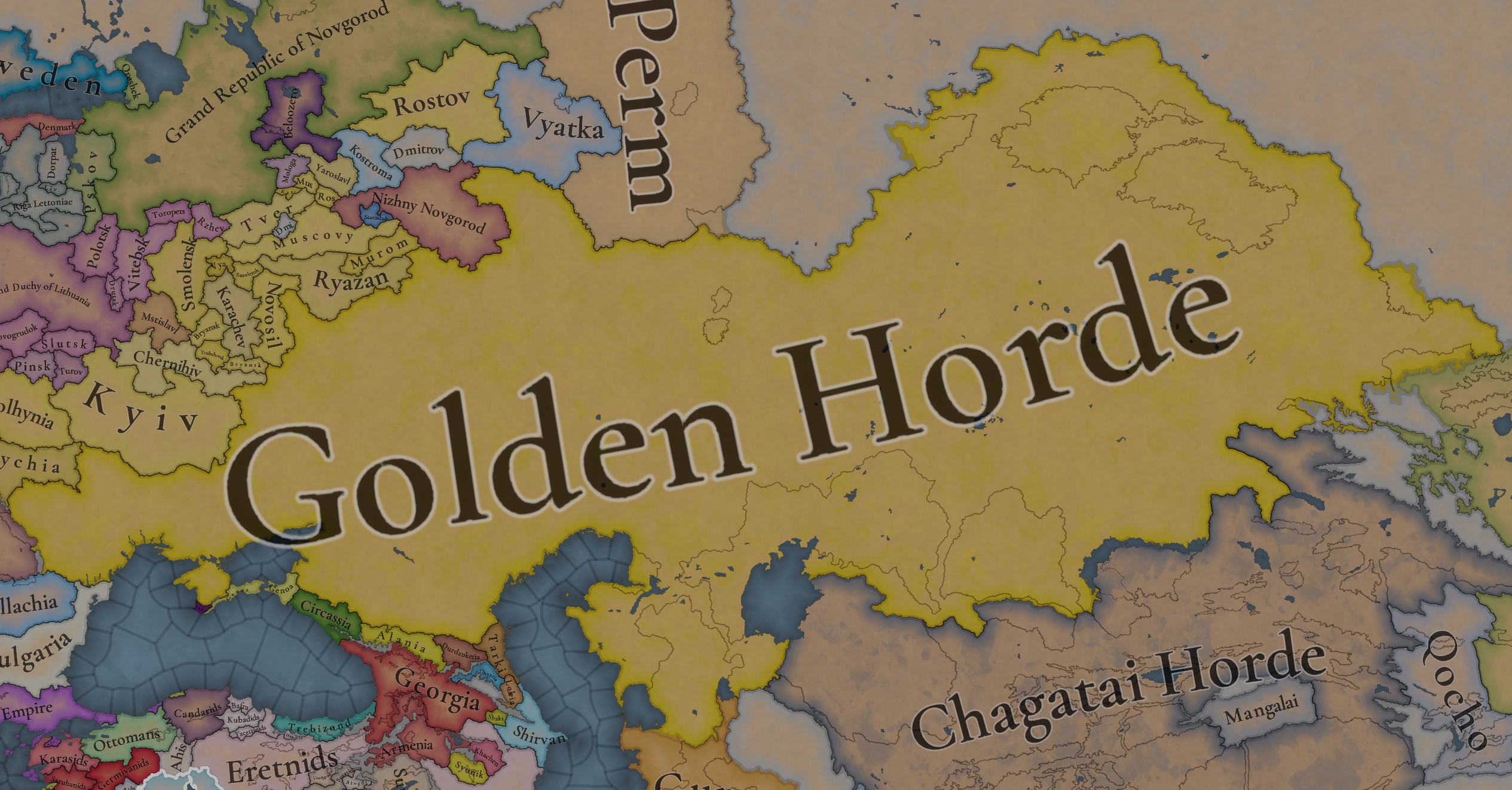
Hello, and welcome one more week to the weekly encounter for map lovers! This week it’s also directed at horse lovers because we will be looking at the Eurasian Steppes, plus the Urals! So let’s start with the maps without further ado.

Countries:
Countries.jpg

Colored Wastelands.jpg

A glorious, Golden Horde! It is at its power peak, under the reign of Uzbeg Khan, so it's a much more menacing presence for its neighbors. However, it has its some internal issues that need to be managed, as you’ll notice in some of the maps, and in the future when we talk about the content for Hordes. The Golden Horde also heads its own IO, the Tatar Yoke, as shown in a previous Tinto Maps:

Tatar Yoke.jpg

We have already corrected the Ruthenian countries that are under the Horde’s Yoke, although we still have to correct the Russian principalities, which will be done in the corresponding Tinto Maps review. We’re also aware that we need to improve a bit the coloring of the IO, to mark not only the Golden Horde as the overlord of these countries, but also that Muscovy holds the title of the Grand Principality of Vladimir, which makes it the ‘enforcer’ of the Yoke. These fixes are also planned to be done in a few weeks.

Societies of Pops:
Societies of Pops.jpg

Societies of Pops 2.jpg .jpg

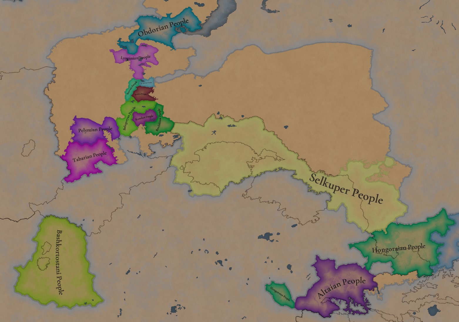
A bit up to the north, we have some Societies of Pops! This means that the territory of Western Siberia won’t be empty land, but will be populated by these people, which can be interacted with.

BTW, I’m not showing this week a dynasty map because, well, only the Borgijin dynasty rules over the lands of the Golden Horde, of course!


Locations:
Locations.jpg

Locations Western Siberia.jpg

Locations 3.jpg

Locations 4.jpg

Locations 5.jpg

Tons of locations today… You might notice that the density location is in a progression from west to east, from the most densely settled areas to the less settled ones. You may also notice that we’ve followed a design of ‘settler corridors’ in Western Siberia, setting those parts of the land that were habitable, usually on river valleys.

Provinces:
Provinces.jpg

Provinces 2.jpg


Areas:
Areas.jpg


Terrain:
Climate.jpg

Topography.jpg

Vegetation.jpg

The terrain is interesting here, as there are two main ecological areas. The first is the Steppes, Flatlands with Sparse and Grasslands vegetation, with either Cold Arid or Continental climates. And then we have the Siberian Arctics Forests, which are completely different, of course. On a note, the Urals were set as Hills, as they’re a quite settleable area, but we’ll probably make a review with your feedback, and add some mountains there.

Development:
Development.jpg

The whole region is not very developed, you might notice the difference with India, from last week’s Tinto Maps.

Harbors:
Harbors.jpg

There are some harbors in the Steppe region… In the Black Sea and Caspian Sea, of course! As usual, we’re open to feedback on this matter.

Cultures:
Cultures.jpg

Plenty of cultures! One note: Although we planned to work on the religious and cultural minorities of the region during the summer, we ended up not having enough time to add them. So what we’ll be doing today is showing the rough outline of ‘cultural spheres’, and then we’ll add the minorities during the review of the region. In that sense, feedback is very well received.

With that said the only note that needs to be made in terms of the cultural design is that we divided the Tatar cultural group into some differentiated regional cultures, being Crimean, Mishary, Kazani, and Astrakhani. We’re also aware that some of the cultures, as Mari and Chuvash, might be a bit displaced, as noted in the Russian Tinto Maps, so we’ll review and correct that with your feedback.


Religions:
Religions.jpg

Regarding Religions, the matter is a bit worse, as the big Sunni blob is just because the main religion of the Golden Horde is Islam, after the conversion of Uzbeg Khan, but that’s obviously incorrect. Also, as we have been able to forecast development time on how Pagan divisions will be during this autumn, we will make a comprehensive review of the region as well, to get a good distribution of ‘Shamanist’ Paganism, Tengrism, and Sunni Islam.

Raw Materials:
Raw Materials.jpg

Raw Materials 2.jpg

Raw Materials 3.jpg

Regarding the raw materials, the Steppes have plenty of Livestock and Horses, quite logically, although there are regions with some other goods. And up to the north, the main materials are Lumber and Fur. Apart from that, I want to mention the mineral hub in the Ural Mountains, with plenty of Copper, Iron, Gold, Lead, and Coal. That makes it a very mid and late-game interesting spot, and playing as Muscovy/Russia, I’ll tell you that you definitely want to expand into that region, as it will fulfill some of your material needs by that time.

Markets:
Markets.jpg

Markets! Big region, with lots of markets, although you may noticed that we changed the coloring of the locations that have 0% market access, which is the case in several areas. In any case, the market centers are Kaffa, Astrakhan, Saray-Jük, Kunya Urgench, Samarkand, Almaty, and Chimgi Tura. BTW, these names are much easier to notice in the game’s UI, as they’re beside the market centers:

Markets 2.jpg


Population:
Population.jpg

This week we’re showing only the country population mapmode, as there are some location numbers here and there which are failing, due to the already known issue with our pop editor (and which are on the way to be fixed). In any case, the whole population of the region is around 6.5-7M, of which around 6.3M are part of the Golden Horde. As I said, it’s a menacing country…

And that’s all for today! This is going to be my last Tinto Maps in a while, as I’ll be on vacation for 3 weeks during October (you might have noticed that I didn’t have any during summer), so one of the Content Designers in the team, @Roger Corominas , will step in and be in charge of the next 4 Tinto Maps. It’s in good hands, as Roger is an Experienced CD, who has been working and focused on Project Caesar for more than 3 years, at this point (this is why you might not know him from EU4, as other CDs in our team). In any case, he will be starting with the regions of Xinjiang, mostly ruled by the Chagatai Khanate, and Tibet.

I’ll keep reading and answering you during next week, and then I’ll be back in a month from now. See you!
 
  • 145Like
  • 48Love
  • 4
  • 3
  • 1Haha
Reactions:


Also I am very much in the camp of not assigning any colour to the horde names, but rather going by their Ulus' instead. A naming convention I would apply to essentially all the Borjigin successor states.

So instead of wondering who is the White Horde or Blue Horde, we say Batu Ulus, Shiban Ulus and Orda Ulus, and of course Ulug Ulus for the Golden Horde.


Last edited:
  • 3
  • 1
Reactions:


Yeah this map includes Shiban in the centre:

View attachment 1207831


Regarding the Sufids, I wasn't entirely sure, as wiki says they were established in 1361. Going through the reference however "The Rise and Rule of Tamerlane" says they gained independence in 1361, so I can definitely include them back on the map as a vassal in that case.


On this paper that I found:
Untitled.png

Untitled2.png
 
  • 2
Reactions:
It's... complicated. We know so little about what was going on in the Orda Ulus at the time (I'm not gonna bother with the color designation because no one seems to know which is which; if you want a laugh, read the Wikipedia page that can't make up its mind on the matter), that we can't even really say one way or the other who ostensibly held it or whether or not it even really existed in a coherent form (the Wikipedia page for Urus Khan, for instance, mentions that Ozbeg Khan "suppressed" it).

It's also worth noting that Wikipedia is laughably wrong many times over on who was even khan of the Orda Ulus. There's this paper that indicates that the first the the Orda Ulus was properly independent (and minting coinage) was in 1368-1369 under a Mubarak Khoja, who was shortly thereafter supplanted by Urus Khan.

Note that if you were to follow Wikipedia, you'd have this article on the fellow. As a consequence of the paper above, every single piece of information on that article is incorrect.

I did manage to find this article which seems to have a good bit of general information. Rather curiously, it includes this detail:
View attachment 1207822
Shiban, to note, is the progenitor of the Shaybanids of the 16th century.

Also note that your map forgets the Sufids.


Countries.png


Locations:
Locations.png


Last edited:
  • 3
  • 2
Reactions:


While currently Özbeg Khan is definitely in a dominant position over the Golden Horde as the ruler of the Blue Horde, the Grey and White Hordes had their own hereditary rulers through the lines of Shiban and Orda Khans respectively, and did try to push their claims over the Blue Horde (and so the entirety of the Golden Horde/Ulug Ulus) during the Great Troubles.

I would suggest that the Golden Horde/Ulug Ulus should be represented by the Jochids of the Blue, Grey and White Hordes, under a "Golden Horde" or "Ulug Ulus" International Organization (separate from the Tatar Yoke IO, though connected via leader of the Golden Horde/Ulug Ulus IO), with it's own mechanics regarding leadership over the Golden Horde/Ulug Ulus (during the Great Troubles, this would also include the other claimant hordes, trying to take leadership of the Golden Horde/Ulug Ulus).

All the Jochid hordes/ulus' should also be able to take independent action on foreign policy, even if they weren't the leader of the IO. For example, the White Horde intervened in the Kaidu-Kublai war.

Implementing this suggestion would add an extra layer of flavor and challenge for playing the Jochids and eventually trying to unite into the same tag of Golden Horde/Ulug Ulus, given you survive the Great Troubles...

This would also perfectly fit into the split of the Mongol forces in the Golden Horde/Ulug Ulus, as I've noted here


Updated map (also includes minor border changes in the East with the Chagatai, Ögedei Ulus and Kyrgyz):

View attachment 1207848

Locations:
View attachment 1207867


I disagree, because I believe the approach they went with Japan will be more close to reality. Instead of creating multiple split nations under IO, better to make building based or army based countries(without land) that will strife to control the entire horde. It will allow for those countries to change their borders as it did happen. Also there were much more of such hordes, not only 3, and the others just allied or here subjugated.
1730028593014.jpeg

1730028548035.jpeg


I also believe it can be a general mechanic to control the steppes. In Russian Tsardom and Empireand in PLC, Cossack hosts also was a strong, independent force. But both empires had also big non-steppe possessions with majority of population compared to hordes. Those hosts had their own politics and did revolt against overlords like Hetmanate.
 
  • 2Like
  • 1
Reactions:
I disagree, because I believe the approach they went with Japan will be more close to reality. Instead of creating multiple split nations under IO, better to make building based or army based countries(without land) that will strife to control the entire horde. It will allow for those countries to change their borders as it did happen. Also there were much more of such hordes, not only 3, and the others just allied or here subjugated.
View attachment 1207913
View attachment 1207912

I also believe it can be a general mechanic to control the steppes. In Russian Tsardom and Empireand in PLC, Cossack hosts also was a strong, independent force. But both empires had also big non-steppe possessions with majority of population compared to hordes. Those hosts had their own politics and did revolt against overlords like Hetmanate.
I think the major point for my approach will be that it is impossible to determine which land belonged to whom because the structure was more about the armies and people and not about the land. And as they were nomadic, those lands changed borders constantly. Representing that with landed countries will be incredibly hard, but both buildings and armies can move by themselves or relocated (latter is more true for Cossacks)

Shaybanids formed around Tumen river and migrated towards Bukhara for example. And that was not by conquest.
 
  • 1Like
Reactions:
I think the major point for my approach will be that it is impossible to determine which land belonged to whom because the structure was more about the armies and people and not about the land. And as they were nomadic, those lands changed borders constantly. Representing that with landed countries will be incredibly hard, but both buildings and armies can move by themselves or relocated (latter is more true for Cossacks)

All hordes are ABC by default though, and ABCs in Project Caesar can own land. How will the 'borders change' constantly if they don't own land?

Do you want the Golden Horde to be a settled country, while a playground for a load of unlanded ABCs? What exactly are they fighting for if not land?

Let's not forget that nomads cannot exist without the land to sustain them, and they fought constantly for the best pastures.
 
Last edited:
  • 2
Reactions:


Yeah this map includes Shiban in the centre:

View attachment 1207831


Regarding the Sufids, I wasn't entirely sure, as wiki says they were established in 1361. Going through the reference however "The Rise and Rule of Tamerlane" says they gained independence in 1361, so I can definitely include them back on the map as a vassal in that case.


Even on this map there are other Khanates like Batu and Berke
 
All hordes are ABC by default though, and ABCs in Project Caesar own land. How will the 'borders change' constantly if they don't own land?
Well the buildings can change the place thy are built for example to represent that migration.
Do you want the Golden Horde to be a settled country, while a playground for a load of unlanded ABCs? What exactly are they fighting for if not land?
i want it to be an elective monarchy between the ulus rulers. And land is not the only valuable part, especially if it is steppes where no one lives.
 
Well the buildings can change the place thy are built for example to represent that migration.

i want it to be an elective monarchy between the ulus rulers. And land is not the only valuable part, especially if it is steppes where no one lives.

I'm going to have to disagree with you on both unfortunately.

A building based horde just sounds wrong. Not just because of "building", but I can only imagine the migration mechanic to be similiar to the native american tribes in EU4.

Considering nomads have a very hard time living anywhere other than the steppe, I will have to point out for example, that the centres of the Ilkhanate were based in Central Anatolia, Azerbaijan and Khorasan, where the only land suitable for nomadic lifestyle could be found, and why the vast majority of nomads don't live in places like France or the Chinese plains.

I am not averse to having all the various minor tribes start off as unlanded ABCs, if they had a way to sustain and grow themselves, but I doubt Paradox has built them to live unlanded forever. But the various Ulus' (states) should be landed, including those of Batu, Shiban and Orda.
 
Last edited:
  • 4Like
Reactions:
It basically comes down to "how do you represent the internal tribal divisions of an Ulus, which oftentime came into direct conflict with one-another?"

The most we can really do is argue that the ones that were directly involved in said conflict with one-another should be vassals. We know of the independent policies of the Orda Ulus, and the Shiban Ulus had relevance in the rise of Tokhtamysh (at that point they were the supporters of a khan in Sarai who only held the eastern part of the Batu Ulus, with the western half being contested by Mamai; both the Shiban Ulus and that other Khan in Sarai supported Tokhtamysh).

Something to note is that, at least with the Chaghatai Khanate, more often than not an individual tumen would become hereditary. A particularly strong ruler would effectively raise an army, and then that army would become a hereditary tumen that wouldn't follow the succession of the Ulus but be inherited separately as a distinct army.

That's what you see on that map. Every single personal army of a notable khan or son of a khan, being assigned a territory of land. Would you be better off trying to represent each distinct group, many of which we simply don't know about (by virtue of the Golden Horde not keeping a recorded historiography)? Or do we abstract it away as a broader system of "powerful nobles"? Or, perhaps, a mix of an approach of both: the most relevant ones as vassals, and the less relevant as simply powerful nobles?

To me the third approach is the most coherent.
 
  • 4
Reactions:


Also I am very much in the camp of not assigning any colour to the horde names, but rather going by their Ulus' instead. A naming convention I would apply to essentially all the Borjigin successor states.

So instead of wondering who is the White Horde or Blue Horde, we say Batu Ulus, Shiban Ulus and Orda Ulus, and of course Ulug Ulus for the Golden Horde.


I strongly agree with this yeah. In addition, I would render "Ulug Ulus" as "Great Ulus" instead, since that's what it means.
 
As i stated a long long time ago, i would supposedly cook up Tatar/Turkic names for the not-Turkic-nameable-yet locations in the Steppes, because if the Khoekhoe got away with somewhat fictional dynamic location names, the Tatars should too! This is not a complaint, btw, i loved what Pavía did in South Africa. But as one might while accomplishing goals...I got ahead of myself, and got myself thinking, "Hey! Crimea is such a diverse place, we should make every possible dynamic name there!", i might have regrets about actually following with this enterprise. But, i still did it, while the whole-Steppe-thing is not done, i did finish the Crimean (Note: I included Chaplynka location in this because of its obvious relevancy to Crimea as the literal location just outside the peninsula) dynamic location bible, and here it is:
Greek
Gothic
Tatar/Kipchak
Turkish/Oghuz
East Slavic
Polish
Lithuanian
Romanian
Italic
Alanic
Chaplynka1
ErodiónRêgrinsBaliqçilinBalıkçılınChaplynkaCzaplinkaČaplinkasStârculuiAironeaKæsaglasy
Theodoro
Theodoro2DoriBalıqlavaBalik-YuvaKorsun3CherszońKersonasIampolCembaloTudory
Qirq Yer4
Sarantikí5SarandQirq YerKırk YerMangushManhuszMangusasMangușPotemàio6Manǧos
Lusta
AloustonAluštaAluştaAluştaAlushtaLusztaLuštasLuștaLustaÆluston
Aqmescit7
FoullaiFūlajAqmescitAkmescitSimferopol(Stary) Krym(Sen.) Krymas(Vechi) Crîm(V.) CrimeaQyrim
Soldaia
SougdaiaSūdachaSudaqSudakSudakSudakSudakasSudăcSoldaiaSuǧdæk
Kaffa
Káffas8KāfaKefeKefeFeodosiaTeodozjaTeodosijaTeodosiaCafàKafæ
Vosporo
BósporosVošporeKeriçKerçKurchevKurcziewKurčievasBosporVosporoKærsy
Seyitler
SegitlérosSējllarSeyitlerSeyitlerSeitler/SeytlerSejtlerSeitelerisSeitălerulSeteleriSejtyler
Jurchi
GioúrtsiDjurtti9CurçıCurçıDzhurchiDziurczyŽurčisGiurciGiorci/GiurciDzurčhy
Kezlev10
KerkinítisKerkenitKezlev11GözleveKozlovKozłówKazlovaCazlăuChesleoKyzylevo
Ak-Mechet
Agmetsi12Agmetta12Aq MeçitAk MeçitAk-MechetAk-MeczetAk-MečetėAc-Mecet13AchimecittiAxmečet
Kalay14
TáfrosFargravaOr QapıOrkapıPerekopPrzekopPerapkasasSăpat PresteOltrafosaDwaræzgeld
NOTES:
1: All names for Chaplynka location are some variety of "heron's place", from the original Chaplynka which just means "heron (fem.)" in Russian. Using this first note to also state that every Gothic name is based on a personal guesswork on the reported material from Crimean Gothic (and for facilitative purposes i assumed it was descended from Biblical Gothic, so that i can use its lexicon).
2: Cherson should be obtainable via event/decision.
3: Sevastopol should be foundable via event/decision.
4: There should be a way to found Bakhchisaray, and its founding should set a flag that changes the dynamic locations' names to Bağçasaray (Tatar), Bahçesaray (Turkish), Bakhchisaray/Bakhchysarai (Russian/Ukrainian), Bakczysaraj (Polish), Bačisarai (Lithuanian), Bahcisarai (Romanian) and Bahčasaraj (Alanic). Also, for this specific location we have the recorded Hebrew (!) name Sela' ha-Yehudim from the Karaites.
5: From the "forty forts" original turkic meaning of Qirq Yer.
6: According to an unsourced Turkish wikipedia claim that the Genoese called it "Potmay", should be in Venetian Potèmajo.
7: Old Krym and Aqmescit should be separate locations instead. Obviously, Phoullai (+ its Gothic variant) and the other Krym variations would go to the new Old Krym location, the Tatar/Turkish name would be Eski Qırım/Kırım, but the remaining Aqmescit location would be lacking a lot of dynamic names, for that i already have: Skythikí (Greek), Okmeszety (Polish) and Akmešitas (Lithuanian), but still could cook something up for the rest if the location is actually divided.
8: Theodosía should be a possible location-renaming via decision/event.
9: <Dj> here is a development of Biblical Gothic /ɟː/ ~ <ddj>.
10: All non-Turkic cultures here should be able to refound the city as "Eupatoria", that is: Eupatoria (Polish/Romanian/Italic), Eupatoría (Greek), Eupatorija (Lithuanian), Yevpatoriya (East Slavic), Ewpaterija (Gothic) and Eupatoriæ (Alanic).
11: Non-Crimean (but still Kipchak) should be Közbla-Üy or Közblüy (all calques meaning "beautiful house" from a hypothetical Khazar Güzliev).
12: Kalos Limen should be refoundable via event, giving Kalós Limín for Greek and Kalulimina for Gothic.
13: I like better the hypothetical Mecet Acului (lit. "the Needle Mosque").
14: Following Ancient Greek's Táphros ("trench"), Crimean Tatar's Or Qapı ("trench gate") and the resulting Slavic translation Perekop ("[the] digging across"), all the placenames are direct translations (with some shortening here and there) meaning "trench/ditch/digging across (to the other side)", i'm not native (nor speak) any of those languages however, so this is a case where any mistake-correcting on my translation is very much welcomed! It does come with the added kink of Venice and Genoa having access to a literal..."Ultraditch", which is just funsies.

Any feedback and suggestions are appreciated! I give it 50/50 if i may come back with the actual Steppe-names...
 
  • 5Like
  • 2
Reactions:


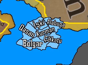
I think adding some Volga Bulgar beyliks as vassals of the Batu Ulus (Blue Horde of my previous suggestion) could make sense and add a nice bit of flavour. The region is said to have been divided between vassal ulus beys (leaders of ulus') who governed the Bulgar Ulus for the Jochids. They are debated to have retained a degree of autonomy under the Mongols since the invasion, leaning more towards a recent surge in political power after regaining much of their former prosperity, with distinct principalities showing up in the first half of the 14th century.


Countries1.png
Locations1.png

Countries.png
Locations.png


1731812605066.png

1731813002015.png

1731813016115.png

1731813273928.png


Most of the information above is from the "Tatar Encyclopaedia" (2002)

1731812146979-f186902f-02e2-436b-b93c-cef2a5abe87ftmp_1.jpg


"Armies of the Volga Bulgars & Khanate of Kazan" (2013)


  • 6Like
  • 1
Reactions:
1731812146979-f186902f-02e2-436b-b93c-cef2a5abe87ftmp_1.jpg


"Armies of the Volga Bulgars & Khanate of Kazan" (2013)
On the map you use Blue Horde placement, the placement of Ulus Shiban and White Horde placement contradicts the ones you use. It also contradicts that Ulus Orda and White Horde are the same thing by putting them on different sides, thus creating 4 Hordes. Or Ulus of Shiban here is a Blue Horde?

Not sure what you want to prove with it.

Also, If the map shows the extent of control of Bulgars, the area of the Khanate of Great Bulgaria has much more territory than all the duchies you showed.
 
Last edited:
I think that steppe, MENA and some other government types need a vassal splinter mechanic to be properly simulated.

Some sort of internal politics mechanic which, if failed to manage, leads to certain territories (weighted with more distant places from the capital among other traits being more likely) splintering as vassals, which one then must deal with with vassal management mechanics.

This sort of thing happened repeatedly in history, and could allow many minor historical polities (as well as an even large number of ahistoric ones) to appear in places where they weren't autonomous enough to justify a separate tag at game start.

In case you were wondering, this sort of splintering seemed to never happen in Europe in the EU era, and I don't know why.
 
  • 4
  • 1Like
Reactions: