• We have updated our Community Code of Conduct. Please read through the new rules for the forum that are an integral part of Paradox Interactive’s User Agreement.

Tinto Maps #22 - 11th of October 2024 - Mongolia, Manchuria and Eastern Siberia

Hello and welcome another week to the amazing world of Tinto Maps. This week we are covering a very wide area, as we will take a look at Mongolia, Manchuria and all Eastern Siberia. So, without much further ado, let’s get started.

Countries
Countries.png

Colored Wastelands.png

Countries zoom.png
Here, clearly, the Yuán Dynasty of China controls much of the territory, while all of the Siberian expanses are “open” to colonization. Considering Manchuria, the Jurchen tribes posed a tricky question, as some of them were more settled and Chinese-influenced while others were more nomadic and pastoralist, and some were in between. Thus, we decided to represent the more settled tribes that would later confederate into the Manchu as separate countries vassals of Yuán, while there is also Jurchen population inside the borders of Yuán itself and the most nomadic of them represented as Society of Pops.

Societies of Pops
Societies of Pops.png

And speaking of that, most of them are obviously concentrated in Manchuria and around the borders of the countries and coasts, while the more inhospitable places further into Siberia and Kamchatka are more sparsely populated and thus less organized.

Dynasties
Dynasties.png

Nothing that wasn’t expected here, Borjigin dynasty keeps dominating another week. Concerning the Jurchen, currently none of them have scripted dynasties assigned and are generated instead.

Locations
Locations.png

Locations zoom 1.png
Locations zoom 2.png
Locations zoom 3.png
Locations zoom 4.png
Locations zoom 5.png
Locations zoom 6.png
Locations zoom 7.png

Provinces
Provinces.png

Provinces zoom 1.png

Provinces zoom 2.png
Provinces zoom 3.png

Areas
Areas.png


Terrain
Topography.png

Climate.png

Vegetation.png

The drier parts of the Gobi Desert in the Mongolian Plateau give way to the steppes and grasslands of Manchuria, while further into Siberia it gets dominated by mountains, hills, forests, and as one would expect from Siberia, cold.

Development
Development.png

Not much development in these parts either, and as I mentioned in last week’s Tinto Maps, the sudden change in development when entering China will have to be reviewed, as it’s currently too strong.

Natural Harbors
Harbors.png


Cultures
Cultures.png

Cultures zoom 1.png

Cultures zoom 2.png
Cultures zoom 3.png
Quite a varied cultural landscape, as these areas are populated by many different peoples, sometimes expanding through a wide area while others are more localized. On the other hand, the Mongolian Plateau is very much dominated by Mongolian culture.

Religions
Religions.png

Very diverse religion distribution too, with Tengri, Shamanism, and local variations of it with Tungustic Shamanism (brown), Yukaghir Shamanism (light blue) and Chukchee Shamanism (purple). I have to say that we are currently going through a review of all the religions of the world defined as either “Animism” or “Shamanism”, so it is possible that there are some changes in this distribution in the future.

Raw Materials
Raw Resources.png

Raw Resources zoom 1.png
Raw Resources zoom 2.png
Raw Resources zoom 3.png
Very marked distribution of resources, with Mongolia and Manchuria rich in livestock and horses (as one would expect from the horse lords) while the forests of Siberia are full of fur and wild game and the northern coasts are a big source of ivory (from the world-famous arctic elephant herds, of course). However, the mountainous areas also include precious metals like gold and silver, so their colonization may thus prove quite beneficial. Another thing of note is that fish can be found abundantly not only along the coasts but also along the major rivers crossing Siberia.

Markets
Markets.png

First of all, we have reverted back to the previous way of visualizing markets, as it was clear that the change we did to it was not in the good direction. We will keep testing and trying things, so this will probably not be the final view of it, but for now we reverted back to this version as we think it would be clearer to present. Having said that, these are areas with not much market presence, with the markets of Karakorum and Ilan Hala being the main ones, and the Chinese markets encroaching on the southern parts. Siberia doesn’t have any market of its own, so all of it has currently no access.

Population
Population.png

Population zoom 1.png

Population zoom 2.png
Population zoom 3.png
Population zoom 4.png
Population zoom 5.png
Population zoom 6.png
The only countries we have population to show here are the Jurchen ones, with the mighty Yuán ever encroaching on them. Concerning the populations of the locations, one thing I have to mention is that you will see many of them with the value of 150, that is the general default value that we used for the less populated areas of all eastern Siberia, where population estimates of the period don’t allow for much fine tuning. It is probably something that we will adjust.

And that is it for this week. Next week, after having been teasing it and slithering around its edges for a while now, it will be finally time to face the dragon, as we will showcase the entirety of China. Hope to see you all there, and as always very open (and grateful) to all your feedback.
 
  • 153Like
  • 48Love
  • 6
  • 3
  • 2
  • 1Haha
Reactions:
I need to point out that the population of Manchuria in the Yuan Dynasty was over 1.5 million, which is equal to the sum of the population of Lithuania and Kiev in the previous tinto maps. I do not think this population is very sparse (especially compared to European countries), while the population of Hokkaido was far below 50000 at that time.
Hokkaido maybe need such loactions to point out the tribes, Manchuria also should have at least more locations to mark those Manchu tribes (I do not think it could close to the location density in Eastern europe, 'cause some people don't want to see the East have so much locations equally to the West)
Was most of this population concentrated in Liaoning and maybe Jilin but probably less in Heilongjiang and 外东北 (Outer Northeast/Manchuria)
 
  • 3Like
  • 1
Reactions:
That's a pretty disingenuous picture given that post-feedback Brittany has 27 locations despite being like 1/3 the size of Hokkaido (not necessarily saying that 56 locations for the latter is objectively warranted).
1/3 the size but didnt japan colonise hokaido till recently. the Ainu were not that numerous and in the whole period of the game japan never went there , that happen in vic3 era .
No , to me this is teams being incosistent with ratio of locations they should make . i can imagine the japanese dudes went full maniac and pationate on this one while those who worked on other areas went with different depths too.

the only time there is an increase of density in the map is when that density is justified either by ( thats the standard used in the whole map) or ( that is a huge concentration of humans in a narrow area like egypt or netherland or HRE or india or china)
this map of hokkaido does not represent the standard ratio of locations per area , its far detailed than the early maps we saw and its not an urbanised area in fact it might have more bears or wolves than peoples.

in my opinion the only solution i personally use in my own map that have 6 digits labels is to rebalance the whole map on the ratio of the area that is empty but with lots of locations and hokkaido is to me should become the default .
if the map resolution cant handle that and will create a crowding effect then increasing resolution could be a solution or if not then a minor rebalance would work such as adding few dozen locations to each country that could have that
 
Last edited:
  • 4Like
  • 1
Reactions:
Can I ask for the reason why there is no passageway at one of the red lines, but only one that goes further to the east? On the culture map it shows that the Yandyr are not continuous, but are split by impassable terrain between the two areas.

sakha.png


Looking at a topographic map of the area, I do not see a reason why there would not be a connection/passageway, considering that there is the Yana river, that I think flows roughly through Uus Kuyga and into Alii province, would facilitate movement of people between the two areas. Even if it is a river tile/passageway that only allows movement when it is frozen over.

sakha-river.png
 
Last edited:
  • 15Like
  • 5
  • 1
Reactions:
Can I ask for the reason why there is no passageway at one of the red lines, but only one that goes further to the east? On the culture map it shows that the Yandyr are not continuous, but are split by impassable terrain between the two areas.

View attachment 1201149

Looking at a topographic map of the area, I do not see a reason why there would not be a connection/passageway, considering that there is the Yana river, that I think flows roughly through Uus Kuyga and into Alii province, would facilitate movement of people between the two areas. Even if it is a river tile/passageway that only allows movement when it is frozen over.

View attachment 1201151
thats why i called it Eve online like clusters . while at it we could also just built iserholn class star fortresses in those corridors since there is no possible way for the horse nomads or bedouins to use that wasteland due to warpstorms
 
I need to point out that the population of Manchuria in the Yuan Dynasty was over 1.5 million, which is equal to the sum of the population of Lithuania and Kiev in the previous tinto maps. I do not think this population is very sparse (especially compared to European countries), while the population of Hokkaido was far below 50000 at that time.
Hokkaido maybe need such loactions to point out the tribes, Manchuria also should have at least more locations to mark those Manchu tribes (I do not think it could close to the location density in Eastern europe, 'cause some people don't want to see the East have so much locations equally to the West)
So this tends to actually reinforce my point, as underlined Hokkaido had much lower population but strangely has much bigger locations.

Whether it’s Hokkaido which has too many, Manchuria too few, or a mix between the two, the case remain true
 
  • 3Like
  • 1
Reactions:
1/3 the size but didnt japan colonise hokaido till recently. the Ainu were not that numerous and in the whole period of the game japan never went there , that happen in vic3 era .
No , to me this is teams being incosistent with ratio of locations they should make . i can imagine the japanese dudes went full maniac and pationate on this one while those who worked on other areas went with different depths too.

the only time there is an increase of density in the map is when that density is justified either by ( thats the standard used in the whole map) or ( that is a huge concentration of humans in a narrow area like egypt or netherland or HRE or india or china)
this map of hokkaido does not represent the standard ratio of locations per area , its far detailed than the early maps we saw and its not an urbanised area in fact it might have more bears or wolves than peoples.

in my opinion the only solution i personally use in my own map that have 6 digits labels is to rebalance the whole map on the ratio of the area that is empty but with lots of locations and hokkaido is to me should become the default .
if the map resolution cant handle that and will create a crowding effect then increasing resolution could be a solution or if not then a minor rebalance would work such as adding few dozen locations to each country that could have that

Japanese settlement of Hokkaido actually started not too long after the games start date during the later 1300s and by 1750 there were more Japanese than Ainu living in Hokkaido, though it should be mentioned the Japanese settlement was all centered in the southern peninsula with the rest demarcated off for the Ainu. (But they still maintained many fisheries in Ainu land). (From Tokugawa World) By the end of EU5’s timeframe the Ainu were pretty firmly within the Japanese sphere of influence, with the Ainu being pretty integrally tied to Japanese system of fisheries in order to trade for Japanese goods.

“The migration of Japanese to the Oshima Peninsula occurred from the end of the Kamakura period to the middle of the Muromachi period. From archaeological records, it is estimated that Japanese migration began in earnest after the late 14th century during the Muromachi period.[1]
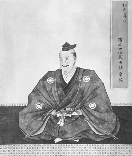
During the Muromachi period , Wajin, Watoto, and Ainu lived in the southern tip of the Oshima Peninsula (later Wajinchi ), and powerful clans built their manors there. [ 33 ]Archaeological evidence has confirmed that Wajin and Ainu lived together at the Katsuyama Mansion ruins, one of the twelve manors built by Wajin in southern Hokkaido. [ 34 ] The manor lords who were based in the area were vassals of the Ando clan , and although it is unclear when they traveled to Hokkaido, it is believed that many of them were descendants of samurai who served as deputies in the Hojo clan territories of Tsugaru and Nukabe during the Kamakura period. [ 35 ] During the Muromachi and Sengoku periods , the number of Wajin crossing the sea from the mainland increased, which caused conflicts between them and the local Ainu. Regarding Hokkaido in pre-modern times, there is the " Silla no Kiroku" (Records of Shinra ) ( completed in 1643 ), which records the origins of the Matsumae Domain, and according to this book, in the Battle of Koshamain in 1457 , Takeda Nobuhiro , who is said to be a descendant of the Kai Genji and Wakasa Takeda clans , killed the Ainu leader Koshamain, securing victory for the Wajin. Nobuhiro succeeded the Kakizaki clan , and his descendants later took the name of Matsumae, establishing control over the southern part of Ezo for generations ( the Matsumae Domain ).”
(Google translation of Japanese Wikipedia)
(Ancestor of the Matsumae clan who beat back the Ainu)
(The first great Ainu uprising that destroyed most of the first Japanese settlements in Hokkaido)

As we have seen, these Northern chieftains had remained more autonomous than
their southern counterparts, but the noose was tightening around them: in 1754, a
Japanese fishery was established in Kunashiri, thus submitting local Ainu to labor in
the fisheries, and the southern limit of Russian settlement reached Shimushir in 1755
(Manabe 1978: 69) and Urup, where a trading post was established at the end of the
1760s (Lensen 1959: 61–85).

The importance of Northern marine products for the Japanese domestic economy,
thus, appears to have created a web of tightening mutual, multi-scalar interdepend-
encies (Figure 21.10). Ainu sustenance activities were increasingly hindered by year-round labor in the
fishery, thus, increasing Ainu dependency on Japanese products, obtained as payment
for their labor. The Matsumae domain and retainers grew increasingly dependent
on the fees provided by the merchant houses. The bakufu was dependent on nor-
thern marine products for the Sino-Japanese trade, as well as the domestic market.
As Fredrick Barth has pointed out, when ecologically interdependent groups are
involved in a symbiotic relationship, variations can create imbalance (Barth 1969:
20). In this case, the rupture point in Ezo-chi originated in the arrival of a new
regional actor: Russia.

As David Howell has amply shown, increased demand in dried Northern marine
products also led to a change in the production process. As we have previously seen,
in the absence of rice stipends from domain retainers, they had been allotted trading
posts in Ainu territory. In the new economic context of the eighteenth century, the
increasing demand in dried marine products prompted more efficiency in the proto-
industrial production, packing, and transport of these commodities, which required
the know-how of merchant houses (see Howell 1995). The clan modified its trading
system from one in which the chigyō nushi (vassal-owner of the trading post) dir-
ectly controlled his own post and adjacent areas to one that allowed the chigyō nushi
to commission merchants to manage trade with the Ainu in exchange for a fixed fee
(unjōkin). Licensed merchant houses (ton’ya) contractually took over the activities
of these posts, and financed and handled the fishing and production processes, giving
birth to the “contract fishery system” (ukeoi basho seido), described as early as 1739
(Sakakura 1979 [1739]: 60)

In these fisheries, each activity required a license that had to be paid annually—
e.g., the herring fee (nishin unjō), the salmon fee (aki unjō, literally “autumn fee”),
and the kelp fee (kombu unjō) (Kikuchi 2003: 244). The average fee per activity
was 71 ryō (Howell 1995: 38). The fees were fixed and didn’t depend on the quan-
tities produced and, thus, the more that was effectively produced, the heftier the
merchants’ profits, unscathed by the domain.
The number of these fisheries evolved from around 60 in 1717 to close to 90 at
the turn of the nineteenth century. The Japanese population in Ezo-chi exceeded
the Ainu population around 1750.6 Each fishery employed at least one manager,
one accountant, one or more interpreters, and a varying number of foremen, who
supervised Ainu labor. The latter two had the closest contacts with the Ainu, and
stayed on site all year long. The wages were low: three shaku of kombu (one meter)
was worth 36 cl. of sake, as were a hundred sea cucumbers (Hokkaidō 1981b: 273).
In 1792, five hundred dried sea cucumbers were worth one bag of rice (2014: 462),
and five salmon had to be paid in exchange for a fishing hook (Hokkaidō 1981g:
301). The plethora of activities carried out in the fisheries, as well as the transform-
ation processes—boiling, drying, salting, packing, etc.—now meant that the Ainu
were employed all year long, and Ainu–Japanese interactions shifted from that of
trading partners to that of quartermasters and laborers.

(From an article in the book Tokugawa World)
 

Attachments

  • IMG_3718.jpeg
    IMG_3718.jpeg
    260,2 KB · Views: 0
  • IMG_1712.jpeg
    IMG_1712.jpeg
    125,6 KB · Views: 0
  • IMG_3718.jpeg
    IMG_3718.jpeg
    260,2 KB · Views: 0
  • IMG_1703.png
    IMG_1703.png
    188,4 KB · Views: 0
  • 3
  • 1
Reactions:
What's your general approach with Russian names for locations in Siberia that didn't see Russian colonization for +300 years after start date? Are you using them because lack of pre-colonial info about the locations? Is there any chance of dynamic renaming, even for prominent locations, like Irkutsk? Would feel a bit off to have those names there when playing non-Tatar Yoke nations. Then there's also some very recent location names, like south-west Kamchatka having locations called Oktyabrs'kii and Kirovskiy, which are Soviet names referring to the 1917 October revolution and a Bolshevik sock puppet respectively. I don't speak Itelmen, Koryak or whatever, but the first fits the location of a former settlement named after an adjacent river, Kikhchik, and the second of a settlement called Apacha, where the names don't have any obvious association to Russian IMO, so maybe names to consider there. There's more of these, like Ugolnye and Polyarny in the Chukotka area, which presumably refer to some relatively recent Russian coal mine and polar settlement.
 
  • 2Like
  • 2
  • 1
Reactions:
Another thing to point out i think the devs should if possible in all their next tinto maps if they can somehow make rivers visible on the location maps because the existence of rivers and their relative positioning makes it alot easier for people to map out extra location densities in specific areas and allows us to give better feedback there was an example of this in the India thread from my memory. Just a thought.
Here's modern rivers and modern internal admin boundaries for the dense area. Remember these are modern and only for reference, yada yada.

rivers: View attachment mongolia rivers.png
admin: View attachment mongolia admin.png

What's your general approach with Russian names for locations in Siberia that didn't see Russian colonization for +300 years after start date? Are you using them because lack of pre-colonial info about the locations? Is there any chance of dynamic renaming, even for prominent locations, like Irkutsk? Would feel a bit off to have those names there when playing non-Tatar Yoke nations. Then there's also some very recent location names, like south-west Kamchatka having locations called Oktyabrs'kii and Kirovskiy, which are Soviet names referring to the 1917 October revolution and a Bolshevik sock puppet respectively. I don't speak Itelmen, Koryak or whatever, but the first fits the location of a former settlement named after an adjacent river, Kikhchik, and the second of a settlement called Apacha, where the names don't have any obvious association to Russian IMO, so maybe names to consider there. There's more of these, like Ugolnye and Polyarny in the Chukotka area, which presumably refer to some relatively recent Russian coal mine and polar settlement.
There's a dynamic naming system; if you want them post a list of locations with the names for different cultures (regionally relevant cultures, in particular). And I'm sure they'd love to get rid of all the modern names; post your list of renames.

From my experience working on suggestions for Central Asia, naming locations in areas with poor records with names you're certain are period-authentic can be hard. Maybe Siberia is like parts of the US and we have a lot of oral knowledge about indigenous names for places despite the lack of written languages, but I hope you can read Russian for that.

Remember that the devs are mapping every aspect of everywhere in the world AND probably doing other development as well; they can't spend two weeks deep-diving Russian sources in the hope of authentically naming 30 Siberian locations. That's a job for us unpaid research interns dedicated forumites.
 
  • 1
  • 1Love
  • 1Like
Reactions:
What's your general approach with Russian names for locations in Siberia that didn't see Russian colonization for +300 years after start date? Are you using them because lack of pre-colonial info about the locations? Is there any chance of dynamic renaming, even for prominent locations, like Irkutsk? Would feel a bit off to have those names there when playing non-Tatar Yoke nations. Then there's also some very recent location names, like south-west Kamchatka having locations called Oktyabrs'kii and Kirovskiy, which are Soviet names referring to the 1917 October revolution and a Bolshevik sock puppet respectively. I don't speak Itelmen, Koryak or whatever, but the first fits the location of a former settlement named after an adjacent river, Kikhchik, and the second of a settlement called Apacha, where the names don't have any obvious association to Russian IMO, so maybe names to consider there. There's more of these, like Ugolnye and Polyarny in the Chukotka area, which presumably refer to some relatively recent Russian coal mine and polar settlement.
It's most likely that locations use the present-day name as a default, and then dynamic naming on top of that. It's not too dissimilar to how provinces in Victoria 2 were grouped according to their present-day country in the files.
 
  • 1Haha
Reactions:
A deep dive into the Nivkh homeland:

Countries/Societies of Pops
This seems mostly fine to me, though I hope that the Amur Estuary/Sakhalin should have extremely low control by the Yuan. While the Yuan did launch successful invasions of Sakhalin, it wasn't a major priority for them, and only one Yuan fort has been found on the entire island of Sakhalin (at Guohuo, already included on the map). As the Yuan Dynasty starts to crumble, this region should very quickly slip out of their control and return to indigenous (Nivkh/Ainu) control. The successor dynasty to the Yuan should have the opportunity to reestablish some control of the region centered on Nurgan, but it should always be peripheral and at risk of slipping away.

Locations
I have a few renaming suggestions, and a few new location suggestions. I don't know if there's a source to confirm that these specific locations existed in 1337, but they are all historical Nivkh settlements (some of which still exist). The exception to this is Kyvrmif, which is the Nivkh name for the Shantar Islands, but I was unable to find a settlement name for the islands, especially as they only seem to have been inhabited up until the 1730s and are uninhabited today. I will include dynamic Russian naming as well.

As someone else has already done a map for Sakhalin locations, I don't have many suggestions, but wanted to ensure that the Nivkh settlements of Pil'vo and Chamrvo are included, as these were located on the historic boundary between the Nivkh and Ainu. Pil'vo appears to have already been suggested, Chamrvo does not. While there were Nivkh populations in the Poronai River valley in the southern half of Sakhalin, they appear to have migrated back there more recently after being forced out following the Ainu arrival in Sakhalin around the 11th-12th century. For Ainu naming, Pil'vo should become Porokotan.

Current LocationNew Location (Nivkh)New Location (Russian)New Province
NurganKul'chiChlyaAmur Liman
NurganOremifNikolayevsk-na-AmuryeAmur Liman
BulavaPxrrongiNizhnee ProngeAmur Liman
DzhukUxtrUkhtaAmgun


NivkhLocations.png


Provinces
I have one new province proposal, and two renamings. First, due to the new locations around the Amur Estuary, I suggest grouping them into the new province Amur Liman. (It could also still be called Amur Estuary, but I prefer to use the Russian term liman). As this now leaves the remaining parts of "Amur Estuary" with none of the Amur Estuary, I suggest renaming it either Shantar (after the archipelago) or Tugur (after the river).

Lastly, as Chumikan is a Russian settlement founded in the 19th century, I suggest renaming the province Uda, after the river on which Chumikan is located.

NivkhProvinces.png


Culture
I have mentioned elsewhere that Nivkh should be the majority culture in Shantar. I have a few other specific recommendations regarding culture, though only one has to do with the Nivkh. First, Pil'vo is described as a mixed settlement; rather than a hard line between Nivkh and Ainu, I suggest this location have a mix of both cultures.

Next, despite the granularity of Siberian cultures, there appears to be one missing: the Negidals of the Amgun River valley, a Tungusic-speaking group. They should likely be the majority in Amgun location, and at least a minority in Dzhuk and my proposed Kul'chi location.

Finally, Tungusic populations did not fully occupy the Okhotsk coast until the very end of Project Caesar's timeline. The original population, closely related to Koryaks, remained at least until the 17th century, when a Koryak population was described as living on the Uda. I would suggest having Koryak minorities stretching down the Okhotsk coast in the area currently occupied by the Eveni.


Sources

Gruzdeva, Ekaterina. 2020. Nivkh toponyms in the Amur-Sakhalin region of the Russian Far East. Altai Hakpo 30, 167–204.

Trekhsviatskyi, Anatolii. “AT THE FAR EDGE OF THE CHINESE OIKOUMENE: MUTUAL RELATIONS OF THE INDIGENOUS POPULATION OF SAKHALIN WITH THE YUAN AND MING DYNASTIES.” Journal of Asian History 41, no. 2 (2007): 131–55. http://www.jstor.org/stable/41933457.

Zgusta, Richard. 2015. The Peoples of Northeast Asia through Time. https://doi.org/10.1163/9789004300439.
 
  • 10Like
  • 3
  • 3
Reactions:
The eastern and southwestern plains of China's Heilongjiang are not dense enough,
Please add some regions
During the Qing Dynasty, tens of millions of people from China proper, gave rise to many cities
If you need to translate a map, I can help for free
 

Attachments

  • 东北.png
    东北.png
    2,9 MB · Views: 0
  • 现在黑龙江.png
    现在黑龙江.png
    92,9 KB · Views: 0
  • 2Like
Reactions:
Can I ask for the reason why there is no passageway at one of the red lines, but only one that goes further to the east? On the culture map it shows that the Yandyr are not continuous, but are split by impassable terrain between the two areas.

View attachment 1201149

Looking at a topographic map of the area, I do not see a reason why there would not be a connection/passageway, considering that there is the Yana river, that I think flows roughly through Uus Kuyga and into Alii province, would facilitate movement of people between the two areas. Even if it is a river tile/passageway that only allows movement when it is frozen over.

View attachment 1201151
The wasteland positioning seems pretty arbitrary in later maps.
To have huge scrap of impassable terrain the Sahara desert makes sense, considering tribes / cities were really punctual and separated by large barren lands. It also makes sense in the Gobi desert or Taklamaklan.

But here in Siberia, it does not in areas such as a river delta (as rightly pointed out) or in between mountain ranges where indigenous peoples mostly lived from land extensively, with a low pop density over a large era rather than individual villages.
The land here is mostly forest, with some grasslands in the eastern Siberian peninsula between mid-height mountain ranges.
 
  • 3Like
  • 3
Reactions:
I need to point out that the population of Manchuria in the Yuan Dynasty was over 1.5 million, which is equal to the sum of the population of Lithuania and Kiev in the previous tinto maps. I do not think this population is very sparse (especially compared to European countries), while the population of Hokkaido was far below 50000 at that time.
Hokkaido maybe need such loactions to point out the tribes, Manchuria also should have at least more locations to mark those Manchu tribes (I do not think it could close to the location density in Eastern europe, 'cause some people don't want to see the East have so much locations equally to the West)
Sidenote : 1.5 Million was also the population of Britanny, or Lombardy, in 1500. If you compare it with Manchuria, that’s a much higher location count.

Of course location size should not be determined only by pop size.
Actually, that would probably even be a wrong design choice, as you want pop density to appear « more colorful » in a population mapmode (you would want to notice in green/yellow/red where a location has a denser or more sparse population.
If you chose location size based only on pop density, then you would end up with the whole world map being represented with a unique color in a pop density map mode, which would make it impossible to identify more wealthy locations.

1728795264759.jpeg

(A pop density voronoi diagram based on Miller)

For that reason, I’m more inclined to have land area be the determining factor
One location being roughly always the same size in real world area units (square miles/kilometers) ; with some local tweaking when necessary to represent bigger empty locations in barren and unpopulated areas (which Sahara mostly is apart from a few specific oasis, unlike Siberia which is roughly homogenous low pop density, but not barren nor uninhabited)
1728795180705.jpeg

(A 15° Tissot indicatrix map based on Gall stereographic, where dot size represent the shape distortion at any latitude)

1728795419084.png

(The type of pop density mapmode you could want to see in game, if all locations were equally sized in real world units (so each location pixel count accurately tuned with Tissot indicatrix value).
You can easily identify where the more population, and to some extent wealth, is located - In 1300 GDP/capita was globally more homogenous than today)

That translates, due to the cartographic distortion of cylindrical maps, to a location size around 2x bigger at 60° north (Siberia, Scandinavia…) than at 45° (reference latitude in Gall stereographic) and about 0.5x smaller at the equator.
Conversely, that’s 2x as many locations at the equator and 0.5 as many at 60°).

Now, you can see on the contrary here, that some locations are smaller in north Siberian lowlands than they are in Manchuria. Which means, given that they are already « exaggerated » by the size distortion of the map at these extreme latitudes, that they are actually much more fined detailed (they represent an area about 2x as small in real world units)

1728795920050.png

(As you can see, Orotko, North Kolyma or Dippa/ Ulaxan around 70° in north Siberian lowland are smaller than Tunguska / Gorin at about 55° in Amur river, which means they represent at least 2x as many real world area units.
Which makes little sense considering these are much lower density areas

IMG_8572.png

On the contrary, previous European maps were more in line, with a higher location count / smaller location pixel size at 45° and lower location count / bigger pixel size at extreme latitudes.


The same can be said, on a much larger scale (world instead of regional) of the coastal and sea province units.
They seem to always be the same number of pixels, whether located at the equator or in the arctic ocean / Bering sea. In real world area units, that translates to being comparatively much smaller.
Let’s say a 100 pixel large coastal location at 45° would represent 100square mile.
At 0° equator on a Gall stereograohic, Tissot indicatrice being 0.5, that means the same 100 sqm area (and distance, although distorted differently along x/y axis) would be represented with 50 pixels only.
At 60° (Scandinavia, Chukchi…), Tissot is 2x which means 100sqm should be represented by 200 pixels.
That means that unless unit speed is also affected by latitudes (EU4 introduced haversine calculation in a later patch), a ship crossing a Coastal location over 1 day, would be travelling 2x faster in an equator location than at 45° degree, or 2x slower at 60° in Bering sea if it took the same time to cross these locations.
 
Last edited:
  • 6Like
  • 4
  • 2Love
Reactions:
The wasteland positioning seems pretty arbitrary in later maps.
To have huge scrap of impassable terrain the Sahara desert makes sense, considering tribes / cities were really punctual and separated by large barren lands. It also makes sense in the Gobi desert or Taklamaklan.

But here in Siberia, it does not in areas such as a river delta (as rightly pointed out) or in between mountain ranges where indigenous peoples mostly lived from land extensively, with a low pop density over a large era rather than individual villages.
The land here is mostly forest, with some grasslands in the eastern Siberian peninsula between mid-height mountain ranges.
Some of the impassible terrain in Siberia does make sense as it corresponds to mountains and wetlands that are even now largely unsettled. Some of the shown provinces do correlate to current and existing settlements, but in an area such as Siberia or Canada (less so with Southern Patagonia) that were not settled largely until fairly recently, it does railroad things a little bit to follow a historical path in terms of where places are settled.

What does not, is that in some areas these wastelands would correspond to rivers and lowlands where you could see settlements being made. The biggest thing that stuck out to me is the Lena River valley has passageways. It's a bit difficult to see as there's no river map to better trace it, but the Lena river roughly follows the yellow line in the image below. I had difficulty figuring out the course of the Aldan river, a tributary of the Lena river, which is the two yellow lines in the lower right. The orange line is the Omoloy river and the green line is the Yana river.

1728800015285.png


After mapping out the rivers, based on province names and some guesswork, I would propose the following two passageways:
1. one following the Yana river (green line) connecting Uus Kuya to either Alii or Ceriimee.
2. the other would be a passageway connecting either Tyul-Gyar/Namii to either Saqqyryyr or Kustuur.

It would be very nice if there were locations all along each of these rivers (Lena and Yana) as this would probably be the best areas where settlements would arise in these locations. Lena's passageways that should be made into additional locations are circled in red.
 
  • 7Like
  • 3
  • 1
Reactions:
Greetings!
Anadyr must be further northeast, the namesake river does flow in Chukence instead.
Yakutsk sea does not exist, that inner sea is called Okhotsk sea (in russian though)
You could rename Yakustk area in East Siberia Tuimaada (which is the native name for that huge plain).
Saha name for the Lena river was Ölüönö which is fun to pronounce
Terrain
View attachment 1197868
View attachment 1197869
View attachment 1197870
The drier parts of the Gobi Desert in the Mongolian Plateau give way to the steppes and grasslands of Manchuria, while further into Siberia it gets dominated by mountains, hills, forests, and as one would expect from Siberia, cold.
Sakhalin island, Primorye should be in continental climates, they are warm enough, Kuril islands might as well be oceanic, they are very wet and have a mild climate.
East half of Kamchatka is pretty densely forested, and southwestern part is a very wet grassland biome. Forests do not go that far north west of Lena river.
East coast of Kamchatka is home to an amazing harbor in Petropavlovsk-Kamchatsky, that freezes for half a year though.
Koryak people lived further northeast in what is Northern Kamchatka, even further northwest Chukchi (native name Luoravetlan) lived. Yukaghirs lived further north.
This is the map of native tribes and peoples of Siberia before the russian colonization and genocides.
1728808576601.png

I want to ask, will be there events regarding Sakha unification by Tygyn Darkhan? He unified Sakha people right before Russians came, so he was very unlucky with the timing.
Thank you.
 
Last edited:
  • 7Like
  • 1
Reactions:
1. Why are there so few locations in Kamchatka? The eastern coast, washed by the Pacific Ocean, has a more favorable climate than the western coast, washed by the cold Sea of Okhotsk. I think the wastelands need to be replaced with locations all along the east coast.

2. The natural harbor at the location of Achava should be green or light green, because Avacha Bay, a large ice-free bay of the Pacific Ocean, is located in this place. I also don't understand the name of this place, maybe you meant Avacha and not Achava?

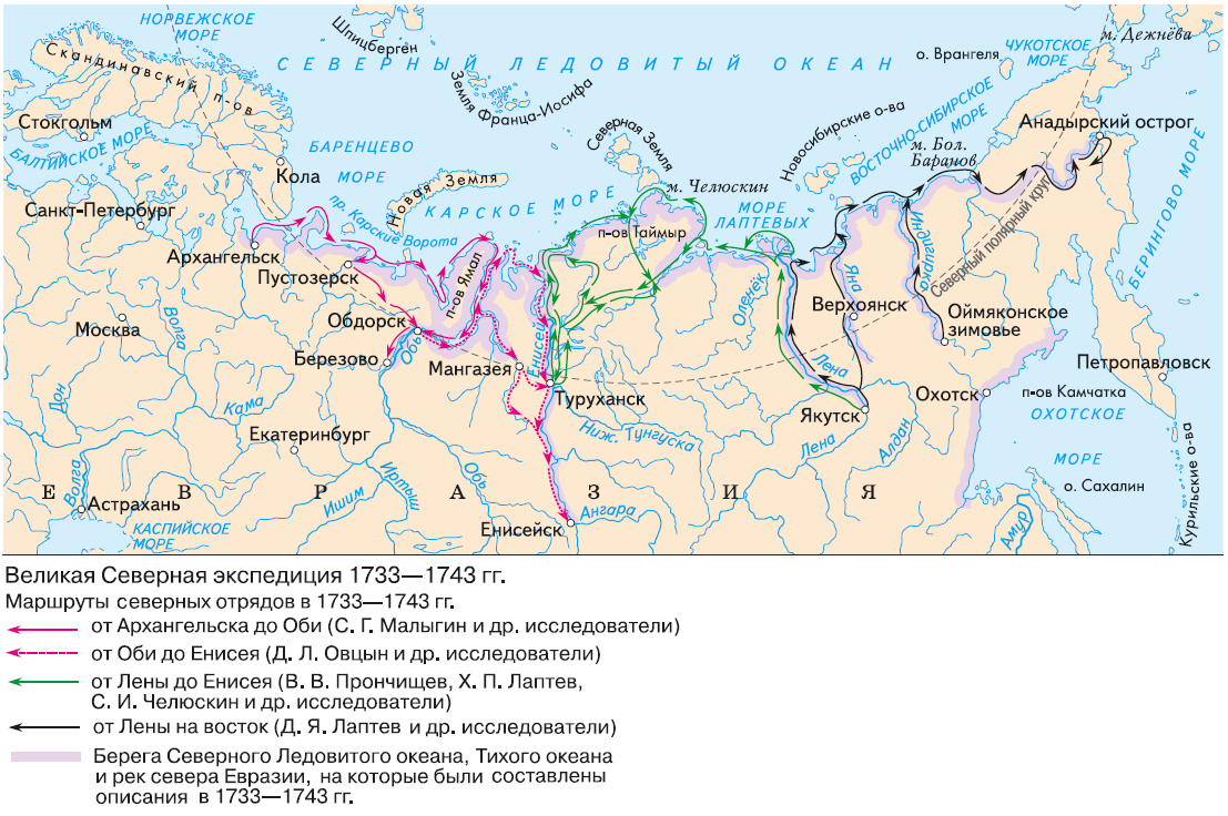
3. I think it is worth making the Northern Ocean navigable, because trade from Russia went all the way to the Gulf of Ob, where the Mangazeya trade route passed. Everything east of Taimyr was mastered by Russian navigators. In PC these expeditions can be a difficult challenge, but they shouldn't be impossible.

Map of the Dezhnev expedition:
1728808754206.png


Map of other expeditions in the 18th century:
1728808804479.png


4. It seems to me that you underestimate the vegetation in Kamchatka too much. There should be more woods on it, especially in the southern half
 
Last edited:
  • 7Like
  • 3
Reactions:
Am I the only one turned off by the thin long locations in Siberia, especially the eastern tip which is mostly made of grasslands in between mountain ranges ?

People in these areas lived on a large land area, not just a tiny road 100 miles long. These location borders feel very « Eurocentric » in that they correspond more to the Russian Siberian trade routes rather the actual living area of native tribes.

On the other hand, there is no actual topographic reason to have these large impassable pockets, as these areas are on the contrary mostly covered with flatlands and rolling hills, and middle to low mountain ranges rather represent the lines than the surface

—-
It looks like the base location size unit is roughly equal on the whole world.
While understandable, one has to remember that the x-scaling distortion inherent to any cylindrical projection, also combined with the lower population density in these areas, could totally support larger locations around the poles (as 1 square kilometer is necessarily « bigger » on map at this latitude than it is at 45° north)
I've heard but don't know if it's the actual reason that they don't want to make provinces outside Europe too big so you don't have EU4 where it takes a week to travel or have the centers be not centralized so walking from 1 side takes a week but the province from the other side takes 2-3 days.

So I guess that forgoes them keeping the chokepoints but made some of the neighboring none wastland provinces bigger or something. Though if it isn't the case I wish they did in western Mongolia/Eastern Kazakstan a bit more.

I've been to the mountainous wasteland provinces in Mongolia. People were driving Priuses right up to just short of the very peak of Huiten Uul (the highest point in Mongolia) without any paved roads or anything yet it's this series of massive impassible blob the size of many European countries. Meanwhile the Carpathians, Alps, etc in Europe are fine lines you can't see zoomed out.
 
  • 3
Reactions:
The wasteland positioning seems pretty arbitrary in later maps.
To have huge scrap of impassable terrain the Sahara desert makes sense, considering tribes / cities were really punctual and separated by large barren lands. It also makes sense in the Gobi desert or Taklamaklan.

But here in Siberia, it does not in areas such as a river delta (as rightly pointed out) or in between mountain ranges where indigenous peoples mostly lived from land extensively, with a low pop density over a large era rather than individual villages.
The land here is mostly forest, with some grasslands in the eastern Siberian peninsula between mid-height mountain ranges.
I disagree with this perspective, if any extremely small amount of people justified a location then even the Sahara should way more filled.

The reality is that if a locality is far from a major river in a way that facilitates or allow a large state both native and external from navigating these impervious regions, has no actual sizeable population either in 1337 or 1800 or today... then what purpose does that locality fulfill? It's just there to make the game laggier or to be ahistorically colonized by Russia or other states?
 
  • 2Like
  • 2
Reactions: