• We have updated our Community Code of Conduct. Please read through the new rules for the forum that are an integral part of Paradox Interactive’s User Agreement.

Tinto Maps #22 - 11th of October 2024 - Mongolia, Manchuria and Eastern Siberia

Hello and welcome another week to the amazing world of Tinto Maps. This week we are covering a very wide area, as we will take a look at Mongolia, Manchuria and all Eastern Siberia. So, without much further ado, let’s get started.

Countries
Countries.png

Colored Wastelands.png

Countries zoom.png
Here, clearly, the Yuán Dynasty of China controls much of the territory, while all of the Siberian expanses are “open” to colonization. Considering Manchuria, the Jurchen tribes posed a tricky question, as some of them were more settled and Chinese-influenced while others were more nomadic and pastoralist, and some were in between. Thus, we decided to represent the more settled tribes that would later confederate into the Manchu as separate countries vassals of Yuán, while there is also Jurchen population inside the borders of Yuán itself and the most nomadic of them represented as Society of Pops.

Societies of Pops
Societies of Pops.png

And speaking of that, most of them are obviously concentrated in Manchuria and around the borders of the countries and coasts, while the more inhospitable places further into Siberia and Kamchatka are more sparsely populated and thus less organized.

Dynasties
Dynasties.png

Nothing that wasn’t expected here, Borjigin dynasty keeps dominating another week. Concerning the Jurchen, currently none of them have scripted dynasties assigned and are generated instead.

Locations
Locations.png

Locations zoom 1.png
Locations zoom 2.png
Locations zoom 3.png
Locations zoom 4.png
Locations zoom 5.png
Locations zoom 6.png
Locations zoom 7.png

Provinces
Provinces.png

Provinces zoom 1.png

Provinces zoom 2.png
Provinces zoom 3.png

Areas
Areas.png


Terrain
Topography.png

Climate.png

Vegetation.png

The drier parts of the Gobi Desert in the Mongolian Plateau give way to the steppes and grasslands of Manchuria, while further into Siberia it gets dominated by mountains, hills, forests, and as one would expect from Siberia, cold.

Development
Development.png

Not much development in these parts either, and as I mentioned in last week’s Tinto Maps, the sudden change in development when entering China will have to be reviewed, as it’s currently too strong.

Natural Harbors
Harbors.png


Cultures
Cultures.png

Cultures zoom 1.png

Cultures zoom 2.png
Cultures zoom 3.png
Quite a varied cultural landscape, as these areas are populated by many different peoples, sometimes expanding through a wide area while others are more localized. On the other hand, the Mongolian Plateau is very much dominated by Mongolian culture.

Religions
Religions.png

Very diverse religion distribution too, with Tengri, Shamanism, and local variations of it with Tungustic Shamanism (brown), Yukaghir Shamanism (light blue) and Chukchee Shamanism (purple). I have to say that we are currently going through a review of all the religions of the world defined as either “Animism” or “Shamanism”, so it is possible that there are some changes in this distribution in the future.

Raw Materials
Raw Resources.png

Raw Resources zoom 1.png
Raw Resources zoom 2.png
Raw Resources zoom 3.png
Very marked distribution of resources, with Mongolia and Manchuria rich in livestock and horses (as one would expect from the horse lords) while the forests of Siberia are full of fur and wild game and the northern coasts are a big source of ivory (from the world-famous arctic elephant herds, of course). However, the mountainous areas also include precious metals like gold and silver, so their colonization may thus prove quite beneficial. Another thing of note is that fish can be found abundantly not only along the coasts but also along the major rivers crossing Siberia.

Markets
Markets.png

First of all, we have reverted back to the previous way of visualizing markets, as it was clear that the change we did to it was not in the good direction. We will keep testing and trying things, so this will probably not be the final view of it, but for now we reverted back to this version as we think it would be clearer to present. Having said that, these are areas with not much market presence, with the markets of Karakorum and Ilan Hala being the main ones, and the Chinese markets encroaching on the southern parts. Siberia doesn’t have any market of its own, so all of it has currently no access.

Population
Population.png

Population zoom 1.png

Population zoom 2.png
Population zoom 3.png
Population zoom 4.png
Population zoom 5.png
Population zoom 6.png
The only countries we have population to show here are the Jurchen ones, with the mighty Yuán ever encroaching on them. Concerning the populations of the locations, one thing I have to mention is that you will see many of them with the value of 150, that is the general default value that we used for the less populated areas of all eastern Siberia, where population estimates of the period don’t allow for much fine tuning. It is probably something that we will adjust.

And that is it for this week. Next week, after having been teasing it and slithering around its edges for a while now, it will be finally time to face the dragon, as we will showcase the entirety of China. Hope to see you all there, and as always very open (and grateful) to all your feedback.
 
  • 156Like
  • 48Love
  • 6
  • 3
  • 2
  • 1Haha
Reactions:
A few more observations eastwards from Krasnoyarsk towards the Angara basin.

Taseyevo - historic name after a local lord called TASEY. Should we use the Russian settlement name? Conversely, the local lord just happened to be here when the Russians came and invented the name. His name was immemorialized by accident, in the grand scheme of things.
IIansky - Ilanka, maybe? It was Ilanskaya originally. Basically, it's an adjective and all three gendered forms have been applied one day or another (because different words for town/village/hamlet have diverse genders in Russian). Ilanka would be a river name. Russian wiki also suggests that it was named after a local lord again: Ilan or OILAN.
Boguchany - Russian wiki suggests that the original Evenk term would be BOGUCHAN without the final -y. However, another (less reliable) source argues it should be BUKACHAN with a different meaning. No -y anyway.
Irkineieva - IRKINEYEVA (more consistent spelling); it seems to originate from a local lord's name, IRKINEY, which was morphed into russian names for settlement and river.
Manzaya - MANZYA (misspelling, extra letter). Alternative is Man'zha but the first one is dominant. In either case, it's a local word and has no meaning in Russian.
Chuva - CHUNA (misspelling)
Upper and Lower Angara - I propose using local villages or rivers;
Upper Angara -> YODARMA (Yedarma, Edarma - a left tributary and a village)
Lower Angara -> ILIM (the bigger right tributary a bit southwards) or KEUL' (an old village from 1690s)
Reka Tuba - reka is superfluous here, it means river in Russian. But in general, the more famous Tuba is to the south of Krasnoyarsk, not here as a tributary of the Ilim. This could be a fitting place for ILIMSK, the Russian fort - but no need for Ilim and Ilimsk together.
Ust-Kut - the Russian settlement on KUTA river.
Icheda - ICHYODA (it is spelt with -ё-, actually. it's a mining settlement but it is also a name of 2 rivers).
locations here are Evenk rivers but I couldn't recognise Sekili and Çamal. They sounded very turkic to my google.
 
Last edited:
  • 3Like
  • 1Love
Reactions:
Going eastwards to Lena River and Irkutsk - I have accidentally come across a topographic dictionary but there are fewer Russian names to check.

Makarixa and Dyrashnichixa - MAKARIKHA and DYRASHNICHIKHA. These are Russian river names. They are not Yakut, so there is no reason to use X to represent the [h] sound here.
Yerema - a linguistic compromise between Russian YERYOMA and native Evenk YEREME. I would prefer the latter one.
Os'kino - it's a valid Russian settlement, but there's a larger native-named place between Khamakar downstream and Yerema upstream: Yerbogachyon, or NYERBEKECHEN, a current district capital.
Irkutsk-Kazachinskoye - there is Irkutsk further south, so unless there's another Kazachinskoye somewhere else I would propose to stick with shorter KAZACHINSKOYE.
Kuytun - English wiki suggests Buryat transliteration as KHÜITEN (with umlaut).
Staraya zima - ZIMA or ZEME. No point in using staraya (old) when there is no novaya (new). It's both a river and a village. It's adapted from local word zeme and doesn't originate in russian word zima (winter).
Zalari - ZALAR. It seems to be an earlier form which makes more sense in Buryat.
Cheremkhovo - ARANGATA is the Buryat name supplied by Mel'kheyev (1969), while wiki surmises that the name comes from buryat word Sheremkhe (Sheremxe?) but wiki references Mel'kheyev and that's not what he wrote.
Slyudyanka - maybe KULTUK. Slyudyanka is vastly more important on several levels (because it's bigger and because it refers directly to mica mining in the area) but Kultuk seems to originate earlier. It appears to be a common turkic term for a river bend or a small bay, so it may not even be original Buryat (may be a Tatar term brought by Russians).
Osenny - (OSENNIY) but I dislike it for the following reason; it does exist as a tributary of the Chuya between Angoya and Konkudera & Kamniga (which are very close along Mama River). And it has been a Soviet cluster of mining camps. The discussed area is in bottom left corner by the place called Gorno-Chuyskiy. I propose SYNNYR because it's a mountain range between two major S-N rivers here (Chuya and Mama). Angoya is separated by Upper Angara Range, and Synnyr goes roughly perpendicular northwards.
 
  • 4Like
Reactions:
Howdy! Wanted to quickly chime in on the conversation with the Ket. While it would be cool to have the Ket split into 2 groups (pompokol + ket) it definitely isn't necessarily needed. The Yeniseian peoples by this point had been significantly stunted. The main group I can think of that was a major Yeniseian power were the Jie people of the 4th century.

Ultimately, Siberia is a lot like Tibet and parts of Africa that are chock full of "unknown unknowns." There probably were at least a few highly divergent isolates that are long gone now but were hanging on by a thread in 1337, but obviously they can't do blood magic in the PDX foyer to summon them or something lol.

I am a MASSIVE sucker for strange isolated cultural groups but I think that with some edits and refinements, the distribution of small groups of people in Siberia is good enough to be an "acceptable fiction." -- though obviously the more the merrier and the more detailed the region is the better.
 
  • 2Like
Reactions:
Some little typos in the Areas map (besides Yakutsk Sea, which is really Okhotsk Sea).

1) Yupper Lena. - I think it's Upper Lena.
And it raises an issue of "Upper Lena" province being a part of the neighbouring area (Middle Lena, duh). Let's rename Upper Lena province into Middle Lena province.

2) Anabyr area and Anaabyr province. What's the point of different spelling here?

3) Krivoshchekovo province at the west edge of the map is called krivoshchYOkovo. (it has a "ё" instead of "e" in the middle).
 
Last edited:
  • 3Like
Reactions:
So I'm using the following article to identify mica mining locations and I have come up with 3.5 places to change a common resource into sand.
Russians prospected for mica on purpose: e.g., Tzar Peter mentioned it in his orders. Sheet mica was then used mostly as window panes.
Possible locations are colour-coded:

0) rivers Taseyeva, Kan and Barga, Kiya and Usol'ye (Angara basin, around Yeniseysk);
I haven't pinpointed this region on the map because the source says mica production fizzled out in just 16 years.
1) river Slyudyanka (south bank of Baikal). As the name suggests, it should contain mica resource instead of bland fish.
2) Mama-Chuya-Witym region. This was a major mica production region until right about the end of the game's timeframe (it lost to glass production gradually). There's a cluster of lumber locations; Chuya or maybe Witym could have sand instead.
3) Aldan region, with sites at rivers Eldmak, Tontora, Mamushkan, Zeya, Uchur, Gonam, Chara. They're inside the blue circle. I think. I hope. Because I just cannot see where these rivers are both on location & resource maps.

Raw Resources.png
 
Last edited:
  • 5Like
  • 1
Reactions:
I think the sites with Lesosibirsk ceramics correlate pretty well with the Yeniseian people.
1741400418900.png

 
  • 2Like
  • 1
Reactions:
now im not an expert by any means and im not really making a substantive in depth suggestion like i have previously but i did see a video recently on youtube that depicted or showed a rather detailed and in depth depiction of Sakha polities in the Lena River valley in the late 15th century. is it possible if this could be applied earlier and anyone who has a stronger obsession than me in this and also more time investigate its historical authenticity?

1743103701713.png


  • 6Like
  • 1
Reactions:
now im not an expert by any means and im not really making a substantive in depth suggestion like i have previously but i did see a video recently on youtube that depicted or showed a rather detailed and in depth depiction of Sakha polities in the Lena River valley in the late 15th century. is it possible if this could be applied earlier and anyone who has a stronger obsession than me in this and also more time investigate its historical authenticity?

View attachment 1272610

Do you want to open the can of worms that is Medieval Yakutia?
 
  • 1Haha
Reactions:
now im not an expert by any means and im not really making a substantive in depth suggestion like i have previously but i did see a video recently on youtube that depicted or showed a rather detailed and in depth depiction of Sakha polities in the Lena River valley in the late 15th century. is it possible if this could be applied earlier and anyone who has a stronger obsession than me in this and also more time investigate its historical authenticity?

View attachment 1272610

As a professional madman, I can tell you that all such videos are not completely historical. As a rule, researchers try to find all the messages about the research object. After that, they receive several dates where historicity is respected. The rest of the dates and the changes that occur on them are made up. The problem is that it is impossible to know for sure which dates correspond to historical reality and which do not. So they should not be perceived as reliable material, but they are an excellent starting point for research.
 
In the far east on Kamchatka, Avacha Bay, (On your map as Achava) should probably be a large natural harbor. The bay is deep, Ice free, protected from storms and has an easily navigable entrance. It was used by the Russians as their primary naval base on the pacific before obtaining Vladivostok, which was further south and could project better.

If you want me to obtain sources for it I can
 
  • 3Like
Reactions:
Final Update on Manchuria
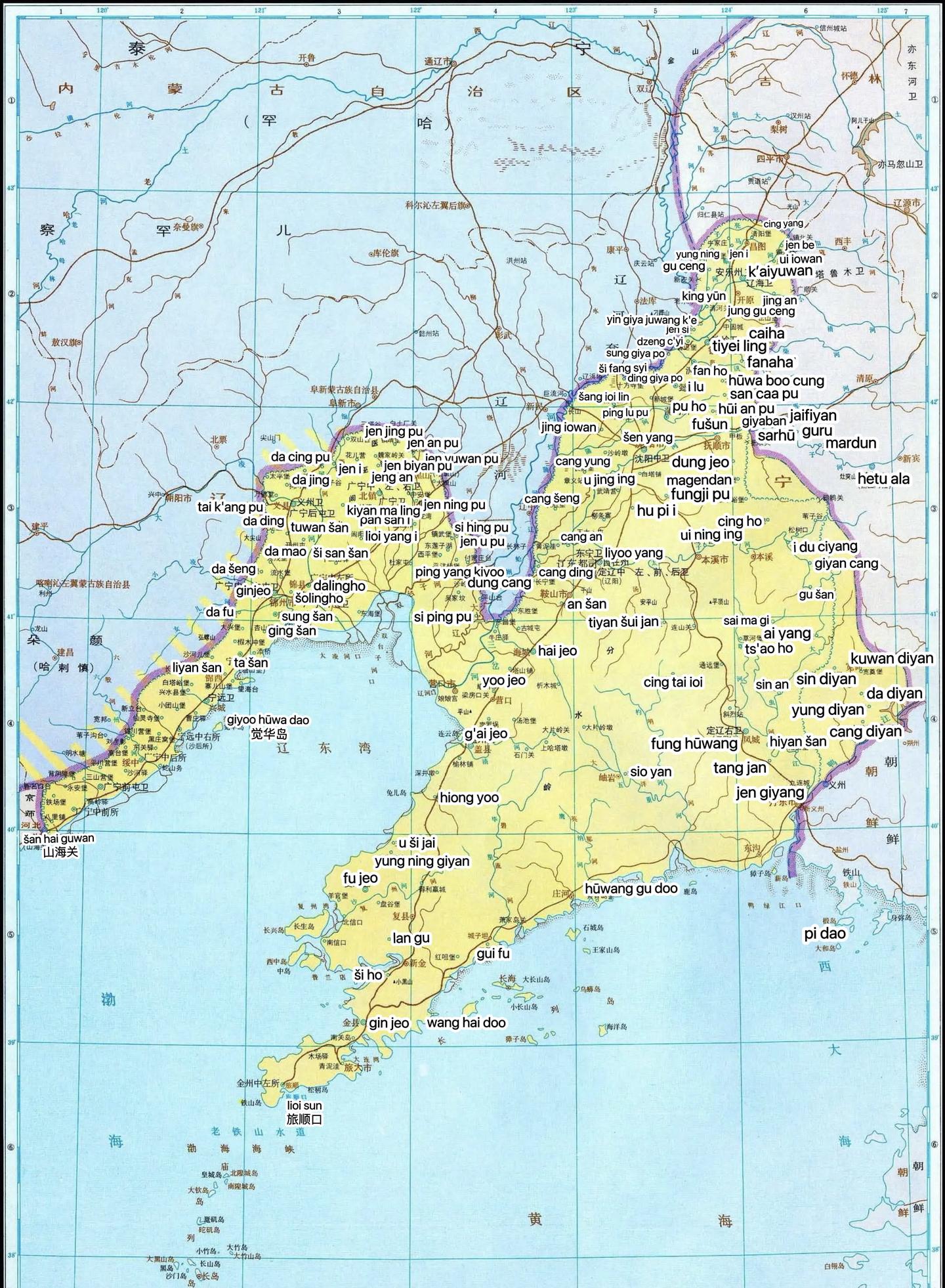
1. How Yuan Dynasty lost Manchuria?
This section is based mostly on Chinese sources as I found almost no English sources, except described how Yuan Dynasty lost Manchuria in the 13th Century. My citations include 元朝对黑龙江下游女真水达达地区统辖研究, 试论元末明初女真人迁徙的原因及其影响, 元末明初朝鲜半岛的女真族与明、朝鲜的关系, 满族从部落到国家的发展, 蒙元东道诸王及其后裔所属部众历史研究, In the Shadow of the Mongol Empire

After the conquest of Manchuria, Mongols conducted brutal genocide against Jurchens, extinguishing their identity by assimilating the remainders to Mongols or Han Chinese, which left a great vacuum in the areas. Manchuria under Yuan Dynasty were dominated by 3 forces, Eastern Uluses led by Mongol princes, Korean immigrants led by Hong Pok-wŏn family, and Liaodong Province under Yuan court. Although the Mongol princes stayed in the West of Manchuria, they enjoyed great autonomy over their "Mongol" subjects, assigned their own officials in Manchuria, and attempted to expand their realm in the whole Manchuria. In response to the aggressiveness, Kublai Khan allied with Korean immigrants and established Liaoyang Province in 1269 to hold back the princes.

As a result, Jurchens became loyal subjects of Mongol princes and adopted Mongol nomadic lifestyle. Yuan government allowed them to resume their old customs, while putting heavy tax and levy on the mere 20,000 Jurchen households. In 1274 and 1280, 15,000 and 3,000 Jurchen men were levied In the notorious expeditions against Japan. In 1292, 5 Jurchen Tumen were established in Northern Manchuria in the conquest of Nurgan and Sakhalin. In 1328-1332, War of the Two Capitals left a devastating consequence in the population of Southern Manchuria. Yuan also demanded Jurchens' obligation to offer falcons and maintain the transportation line, which added to the economic burden of Jurchens.

The chaotic regime of Mongols impact the livelihood of Jurchens. In 1320, Yuan government cut the expenditure to maintain the courier route and its administration in Nurgan, resulting in unemployment and great discontent among Jurchens. Later in 1346, Weji Jurchens refused to offer falcons and openly revolted against the government. Soon, Jin loyalists in Southern Manchurian initialed two revolts in Southern Manchuria. Although the loyal 5 Jurchen Tumens were the major forces to suppress these revolts, the government cut down their size to 3, Odoli, Hurga, and Ton.

As the collapse of the empire approached, the Jurchen loyalists became the targets of tribal feuds. While the Red Turbans raged in Southern Manchuria and Korea in the 1350s and 1360s, 3 Tumens began migrating to the south in fear of revenge from Weji Jurchens. In 1371, the government of Liaoyang Province officially surrended to Ming Dynasty. In the following year, Weji Jurchens attacked 3 Tumens the city of Xiguan (around Huncun). According to Ming Dynasty records, Xiguan surrended to Ming in 1378 under the hereditary "Han Chinese" ruler from Tieling, Zhu Nayanbuqa. The pressures from Weji, Mongols, and Korea forced the rest of the tribes eventually united under Li Manju, grandson of Wanggiyan Ahachu. (his name is possibly the origin of Manchu, his father was given the Chinese surname Li by Emperor Yongle)

As Jianzhou Jurchen migrated and united, the 4 clans around Hulan River Basin also migrated to south for both trade revenue and protection against Mongols and tribal feud from Yeren Jurchen in the early 15th Century. Yehe, Hada, Ula, and Hoifa were named Haixi or Hulun, settling around the boderland trade center Kaiyuan. In a nutshell, all the Jurchen tribes are not in the right places for now. The migration of Jianzhou Jurchen should start not earlier than 1347, while the Haixi Jurchen should not migrate before the border trade began in 1406.

1746655258122.png

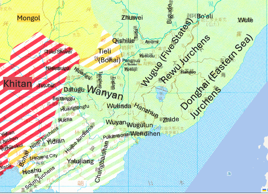
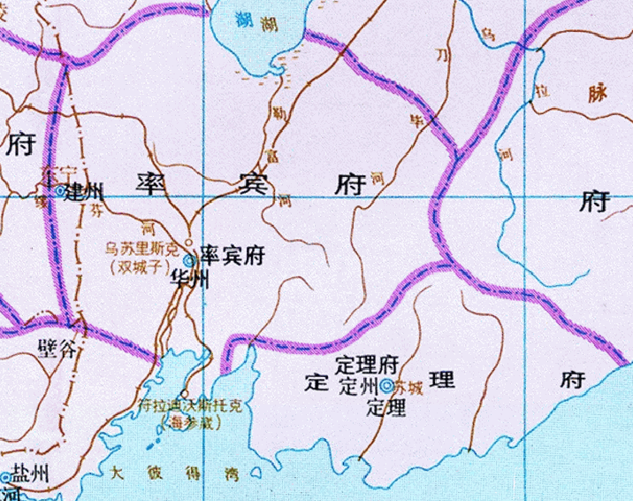
Translation of 10-12th Century Minority Migration and Distribution Map from 中国移民史

Major Divisions: (X Jurchens/Khitan/Bohai)
This section is to illustrate the possible division of states and SoP according to various sources, especially on the divisions of Shu Jurchen under direct control of the central government and Sheng Jurchen under indirect control.
  • 生女真 Sheng Jurchen (lit. Wild Jurchen)
    • 渤海 Bohai/Balhae
      • 渤海 Bohai/Balhae, relocated to Liao River Basin after Liao conquest of Bohai in 926 (see Xiaoliao)
      • 铁骊/铁离/铁力 Tieli or 铁甸 Tiedian (often confused with nearby Turkic Tiele people) , i.e. Tieli Clan of Heishui Mohe and Bohai State, subjugated and relocated by Liao in 926, joined Jurchen Jin Dynasty in 1114
      • 兀惹女真 Wure Jurchen 兀者女真 Wuzhe Jurchen (Uše Jušen in Qing document, uše = Belt, or Weji Jušen, Weji = Forest) It should be Udege or Oroch who are know for their connection with the forest.
      • 含国部 Hanguo Clan. Its leader 斡豁 Hanhuo rebelled against Wanyan Jin Dynasty in 1104 and defeated in 活罗海川 (Hurga River). Unknown relationship with later Hurga Tribe.
      • 东海女真 Donghai Jurchen 滨海女真 Binhai Jurchen (Namuka Jušen, namu = ocean, -ka = people) refers to Warka, Hurga, and Weji in Ming Dynasty records - Weji should be an alternative name for Wuzhe Jurchen.
    • 五国部 Wuguo (Five States) Clan, Jurchen tributaries originated from Heishui Mohe, often categrized to Sheng Jurchen, headed by Liao-appointed Wuguo Qiongshuai (lit. Chieftain marshal of five states) (1: 满洲源流考 Imperial Manchu history sponsored by Qianlong Emperor 1777; 2. 五国城与五国国名的破译 modern historian Liu Wensheng & Zhang Taixiang 2006)
      • 越里吉国 Yueliji State - (1: ilhi ~ deputy; lrahi ~ waves) = 斡朵怜军民万户府 Handuolin Tumen (Odoli Tumen) head of Ilan Hala (lit. Three tribes: Odoli, Hurga, and Ton) = Yilan County
      • 盆奴里国 Yuepenli State = 陶温军民万户府 Taowen Tumen in Yuan Dynasty = 屯河卫 Tunhe Wei in Ming Dynasty (name after Tangwang River - Ton Bira) = in Tangyuan County
      • 越里笃国 Yuelidu State (Qing - iletu ~ openly; modern - yerutu ~ cave) or 宛里城 Wanli City= 脱斡岭军民万户府 Tuohanling Tumen in Yuan Dynasty (Toweri Alin - winter mountain) = 万里河卫 Wanlihe Wei in Ming Dynasty = in Huachuan County
      • 奥里米国 Aolimi State (1: Mongolian loanword Olom ~ ferry crossing; 2: oirma ~ Manchurian trout) = in Suibin County
      • 剖阿里国 Bo'ali State - (1: Bohoir - Garden Pea; 2: beri - bow) = Khabarovsk
    • 生女真 Sheng Jurchen (under the stricter categorization)
      • 完颜部 Wanyan Clan (Wanggiyan)
      • 徒单部 Tudan Clan (Family name 圖克坦氏 Tuktan in 八旗滿洲氏族通譜 Eigh Banners Genealogy Dictionary)
      • 唐括部 Tangkuo Clan (湯務氏 Tanggū in dict.)
      • 泥庞古部 Nipanggu Clan (尼瑪哈氏 Nimaha in dict.)
      • 乌林答部 Wulinda Clan (吳靈阿氏 Ulingga in dict.)
      • 乌延部 Wuyan Clan (吳雅氏 Uya in dict.)
      • 温迪痕部 Wendihen Clan (溫特赫氏 Untehe in dict.)
      • 职德部 Zhide Clan (哲爾徳氏 Jerde in dict.)
      • 乌古论部 Wugulun Clan (吳庫理氏 Ukuri, Chinese family name 商 Shang)
      • 达鲁古部 Dalugu Clan (refer to Mongolian loanword Darga ~ chief in 钦定辽金元三史国语解 Manchu Translation of History of Liao, Jin, and Yuan Dynasties, some sources claim it's Daur 辽金时期的达斡尔族先人——“达鲁古” 卓仁 2019; or named after 洮儿河 Tao'er River, Toor Bira)
      • 斡准部 Hanzhun Clan (Hūkjun per tsl. lit. Storks)
      • 蒲鲁毛朵部 Pulumaoduo Clan (tsl. -> lit. "blue Mandala" in Mongolian, but "Bor Manja" means Brown Mandala. )
  • 熟女真 Shu Jurchen (Civilized Jurchen) The structure is unclear due to lack of materials.
    • 北女直 Bei Jurchen (North Jurchen)
    • 南女直 Nan Jurchen (South Jurchen)
    • 回跋女直 Huiba Jurchen (Hoifa Jurchen)
      • 黄龙府部 Huanglongfu Clan (????, in Kaiyuan)
      • 长白山部 Changbaishan Clan (golmin šanyan alin?)
      • 鸭绿江部 Yalujiang Clan (Yalu Ula?)
      • 北唐古部 Beitanggu Clan (North Tangut?)
      • 移典部 Yidian Clan (启东录 1879 -> idekhiig in Mongolian- ask sb. to eat) relocated from Changbaishan Clan
        1746733360981.png
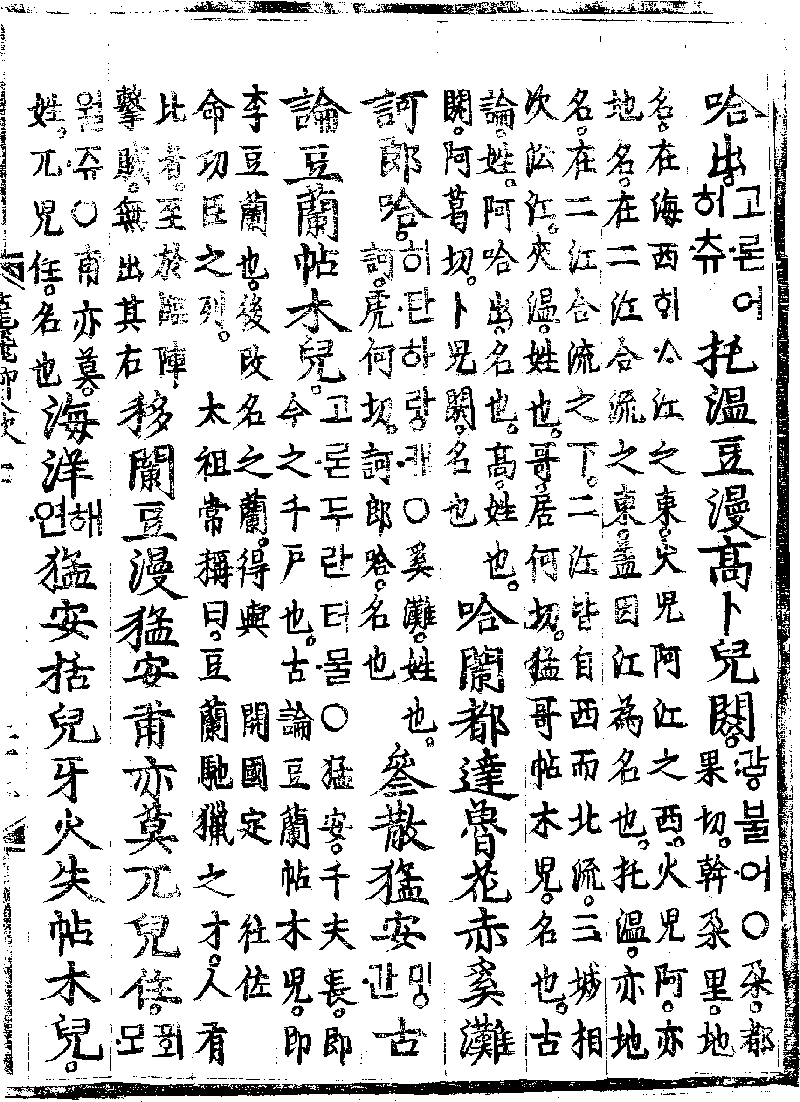
According to Yongbieocheonga, the leaders of Odoli, Hurga, and Ton were 夹温猛哥帖木儿 Jiawen Mengge Tiemuer(가온멍거터물 gaon meongga temul)Gioro Möngke Timur, 古论阿出哈 gulun ahachu(고론어하추 goron eohachu) Gurun Ahachu, and 高卜儿阏 Gao Bu'eryu (광불엉 gwang buleong) possibly Gūwalgiya XXX.

Mistakes on the map

to be done...
 
  • 9
  • 4Like
  • 1
  • 1
Reactions:
1746942523863.png


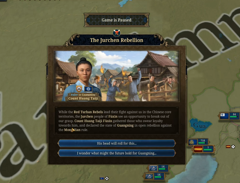
What is this event? I saw that this event will make the whole Northern Manchuria uncolonized.
 
  • 4
  • 1Like
Reactions:
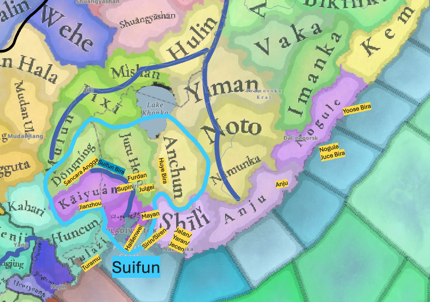
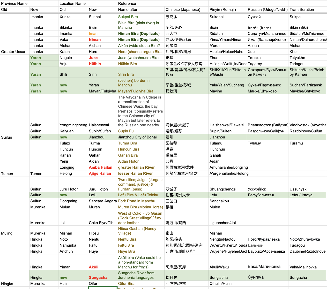
Just made a detailed study over the naming around Vladivostok
1747050059959.png

1. Suifun Region Supin, Shuaibin, and Suifun are historical names for the Suifen River and its surroundings. The Suifun River Basin should be designated as the Suifun Region. I used the Shuaibin Fu of Bohai State (The Historical Atlas of China) as a reference when designing the region.
1747040843558.png

2. For locations, the primary reference is https://pic4.zhimg.com/v2-0936c455171b8e2aa565427a9310805b_r.jpg. based on Later Qing Dynasty placenames.
2.1 Vladivostok -> Haišenwei (alternatively, -> Mayan), but I'm not sure these cities are in the place.
2.2 Shili -> Sirin or Siren in Manchu according to late Qing Dynasty maps. (Yaran was used in EU4 within the location, deriving from Jalan Mingghan (耶懒猛安) in the Jin Dynasty; In the Qing Dynasty, Jecen (lit. border) was used to refer to the city on the Yaran, while Chinese and Russian borrowed it as Sucheng (苏城) and Suchan. )
2.3 Dongming -> Sancara Angga, lit. fork road in Manchu, the original Chinese name 三岔口镇, expressed the same meaning.
2.4 Tulazi -> Turamu (Turamu Bay was renamed to Slavyansky Bay in 1972)
2.5 Kaiyuan -> Jianzhou (where Jianzhou Jurchen got their name; avoid duplicate; Kaiyuan = Jianzhou according to 金标:建州女真的迁徙与源流考述)
2.6 Nogule is a Udege name, while the earliest Chinese record called a river in this location Zhuqi (朱其), probably from Juce (outpost) in Manchu.
2.7 The city of Supin is not within the Juru Hoton but on the other bank of the Suifun against Furdan and Julgei - Ussuriysk, within Jianzhou location.
2.8 Yoose Bira (Ming Dynasty set Yushi Mingghan (鱼失千户所) in the place)
2.9 Anuchino's origin is suspicious and may not be Anchun (lit. Gold) in Jurchen. Vladimir Arsenyev cited the founding legends of the Jin Dynasty (Anchun Gurun) for its naming, but the region did not have much connection with the early Jin Dynasty. According to the local public library, the city was named after Dmitry Anuchin. In Manchu maps, only the River, Huye Bira (瑚叶河;呼也河) = Arsenyevka, was mentioned in the valley. The river was later renamed to Daobihe (刀毕河) in Chinese, and the Russians borrowed the Chinese name as Dolbyhe or Daubihe until 1972.
 

Attachments

  • 1747039573037.png
    1747039573037.png
    398 KB · Views: 0
Last edited:
  • 6Like
  • 2Love
  • 2
Reactions:
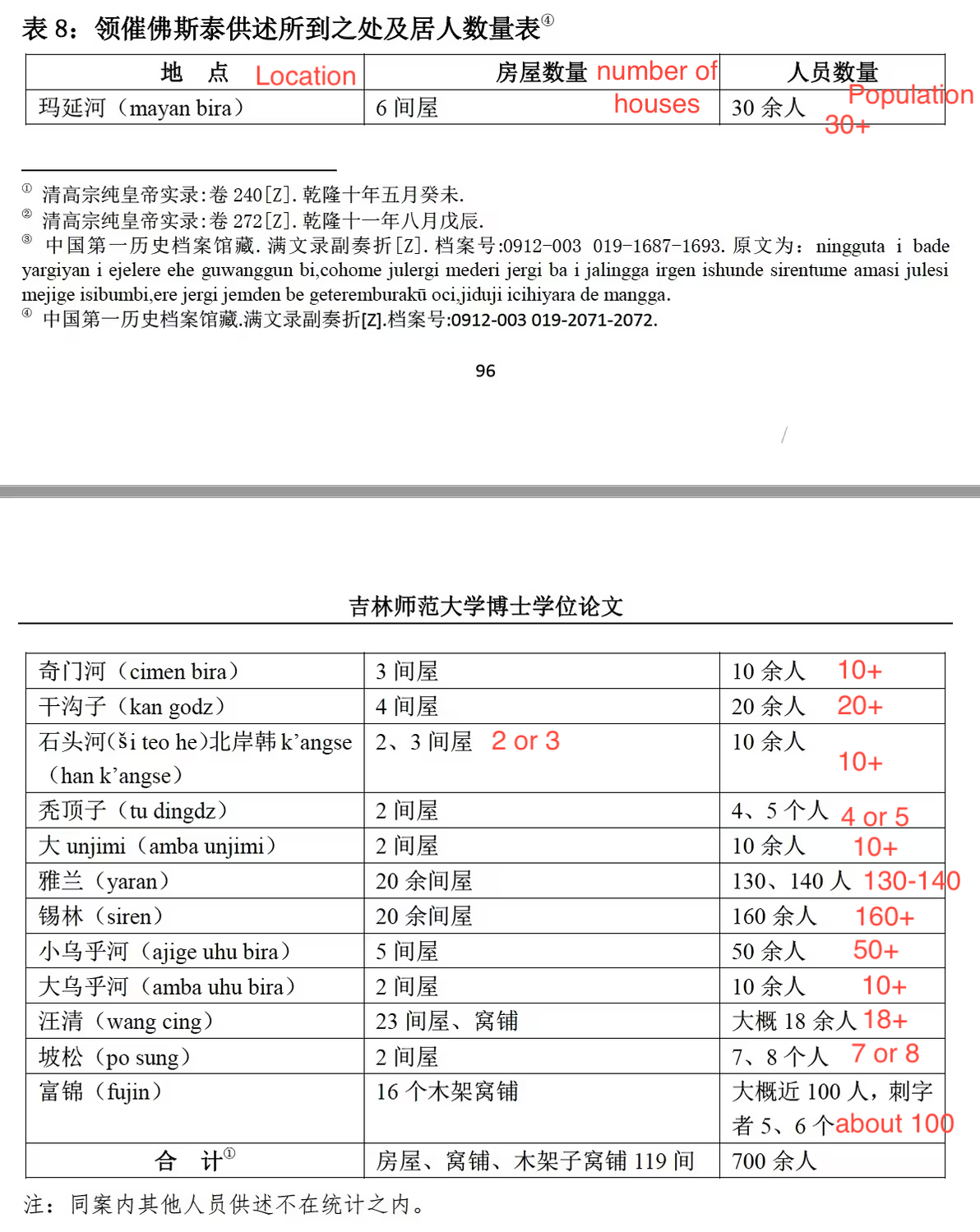
In 1746, Manchu smugglers' account of locations around Huncun:
1747080466185.png

They did not mention Haišenwei (later Vladivostok) but Mayan Bira (Shtykovo, Maykhe before 1972) around was mentioned.
 
  • 2
Reactions:
Names in Ussuri
Screenshot 2025-05-17 at 12.40.23.png
 
  • 4Like
  • 4
Reactions:
View attachment 1295644

What is this event? I saw that this event will make the whole Northern Manchuria uncolonized.
I think all of them instantly became Society of Pops, which is a weird game design honestly.
Then again, can't tell much about it because I still don't know how SoPs and settled nations interact with each other.
 
  • 4Like
Reactions:
  • 6Like
  • 1
Reactions:


I believe the Mongolian (Khalkha) culture should spread a bit further East, to represent the Khorchins and Kharchins who inhabited that area.


View attachment 1200567
View attachment 1200569


I am still reviewing this part. But I believe that an independent Uriankhai culture could be better to describe this feature. When I sought the etymology of Haixi Jurchen placenames in the southern Manchuria, I found many of them were borrowed from Khitan or Mongolian languages, which indicated the strong influence over this region before Haix moved in. I saw the Wikipedia article of Uriankhai stated that Uriankhai controlled southern Manchuria in the 14th century, with a citation on The Cambridge History of China. This is exactly what I said on the politics of Manchuria.

Culturally speaking, Uriankhai was people of forest and closer to Oirats instead of Mongols though they lived in different ends of the steppes. Mongols called all kinds of people from the forest "Uriankhai", even including many Jurchens. Interestingly, Fuyu Wei of Uriankhai people during Ming Dynasty called themselves Weji, clearly a Jurchen loanword for forest people. Additionally, two of four headmen of Haixin Jurchen clans came from Uriankhai. Sibe was also a subject of Uriankhai before Khorchins conquered Uriankhai.
 
  • 4Like
Reactions:
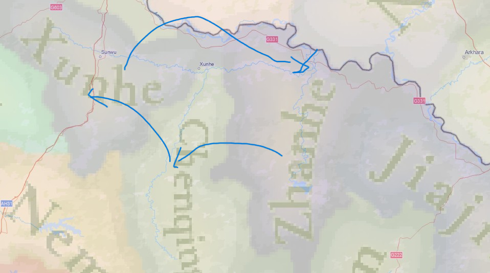
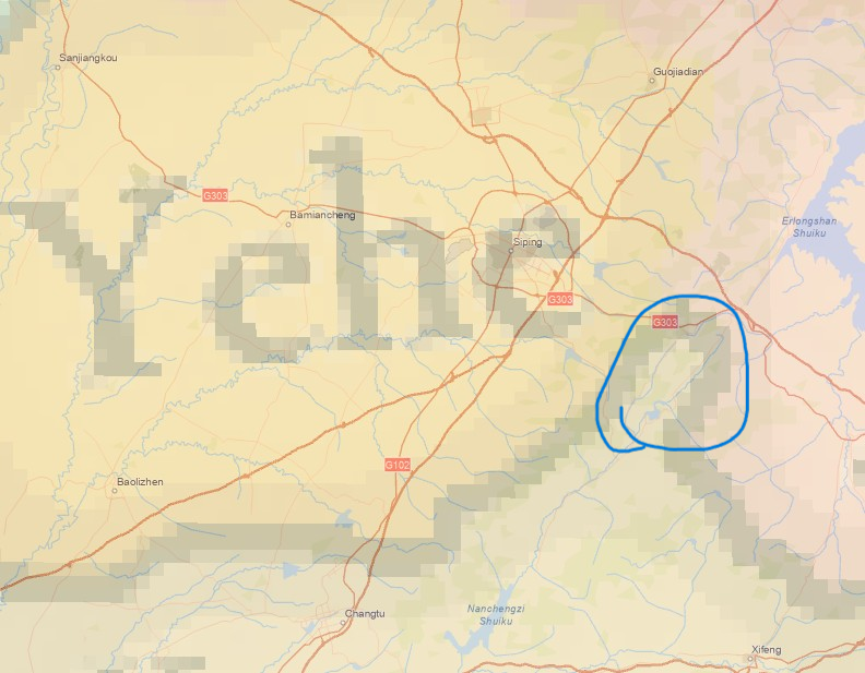
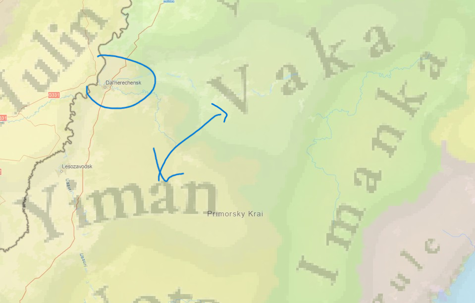
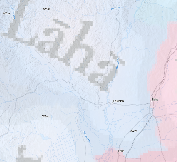
Here are some mistakes I found on placenames of Manchuria:
1. Zhanhe -> Xunhe; Xunhe ->Chenqing; Chenqing -> Zhanhe (Both Songwu and Xunhe are on the River Xunhe; Songwu is the estuary of Chenqing and Xunhe is that of Zhanhe)
1747885163930.png

2. The Yehe city is in that circle, but the Yehe Location did not include it.
1747885081203.png

3. The circled the city is Iman/Niman/Yiman; The Vaka River is the lower one from the city, while the Iman River is the upper one.
1747885228000.png

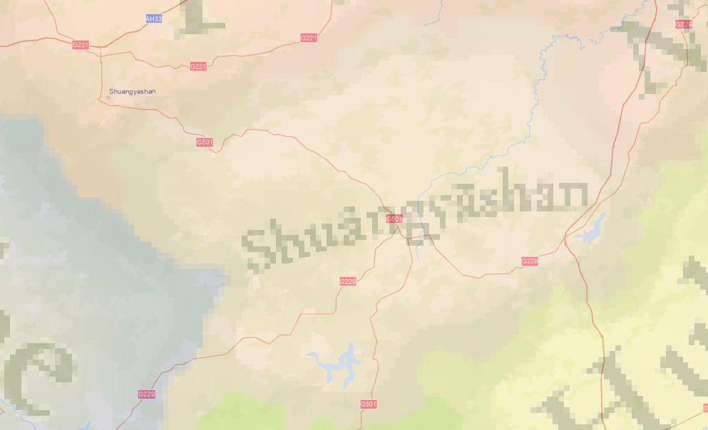
4. A Shuangyashan Location without Shangyashan
1747885286085.png

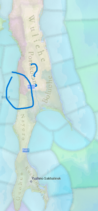
5. Poro Kotan is modern Pilvo, not inland nowhere
1747885650660.png

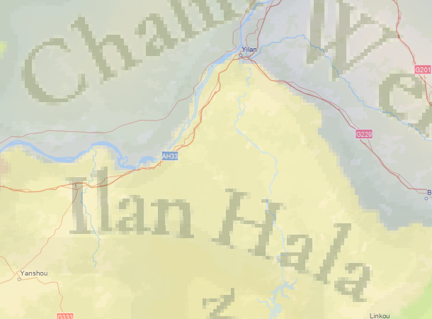
6. Ilan Hala without Ilan
1747896471187.png

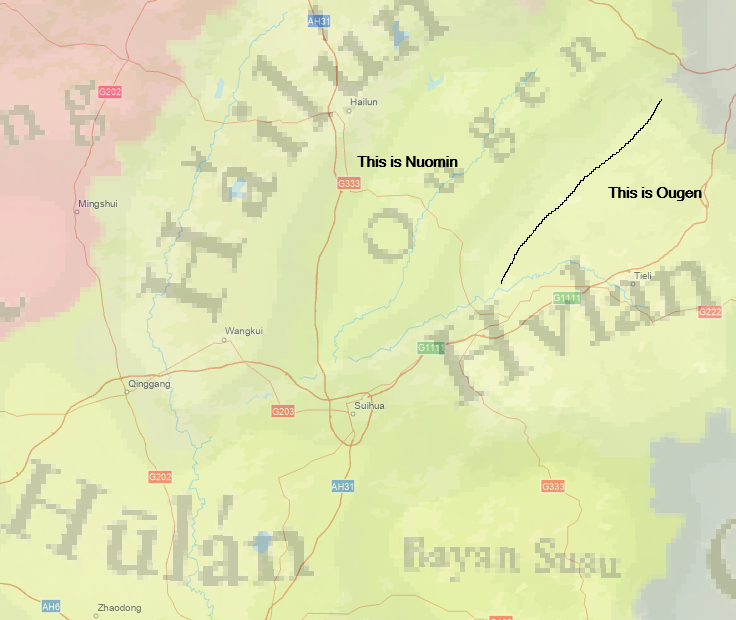
7. Another mistake on rivers
1747906357589.png

8.
1748073190306.png
 
Last edited:
  • 7Like
  • 2
  • 1
Reactions: