• We have updated our Community Code of Conduct. Please read through the new rules for the forum that are an integral part of Paradox Interactive’s User Agreement.

Tinto Maps #22 - 11th of October 2024 - Mongolia, Manchuria and Eastern Siberia

Hello and welcome another week to the amazing world of Tinto Maps. This week we are covering a very wide area, as we will take a look at Mongolia, Manchuria and all Eastern Siberia. So, without much further ado, let’s get started.

Countries
Countries.png

Colored Wastelands.png

Countries zoom.png
Here, clearly, the Yuán Dynasty of China controls much of the territory, while all of the Siberian expanses are “open” to colonization. Considering Manchuria, the Jurchen tribes posed a tricky question, as some of them were more settled and Chinese-influenced while others were more nomadic and pastoralist, and some were in between. Thus, we decided to represent the more settled tribes that would later confederate into the Manchu as separate countries vassals of Yuán, while there is also Jurchen population inside the borders of Yuán itself and the most nomadic of them represented as Society of Pops.

Societies of Pops
Societies of Pops.png

And speaking of that, most of them are obviously concentrated in Manchuria and around the borders of the countries and coasts, while the more inhospitable places further into Siberia and Kamchatka are more sparsely populated and thus less organized.

Dynasties
Dynasties.png

Nothing that wasn’t expected here, Borjigin dynasty keeps dominating another week. Concerning the Jurchen, currently none of them have scripted dynasties assigned and are generated instead.

Locations
Locations.png

Locations zoom 1.png
Locations zoom 2.png
Locations zoom 3.png
Locations zoom 4.png
Locations zoom 5.png
Locations zoom 6.png
Locations zoom 7.png

Provinces
Provinces.png

Provinces zoom 1.png

Provinces zoom 2.png
Provinces zoom 3.png

Areas
Areas.png


Terrain
Topography.png

Climate.png

Vegetation.png

The drier parts of the Gobi Desert in the Mongolian Plateau give way to the steppes and grasslands of Manchuria, while further into Siberia it gets dominated by mountains, hills, forests, and as one would expect from Siberia, cold.

Development
Development.png

Not much development in these parts either, and as I mentioned in last week’s Tinto Maps, the sudden change in development when entering China will have to be reviewed, as it’s currently too strong.

Natural Harbors
Harbors.png


Cultures
Cultures.png

Cultures zoom 1.png

Cultures zoom 2.png
Cultures zoom 3.png
Quite a varied cultural landscape, as these areas are populated by many different peoples, sometimes expanding through a wide area while others are more localized. On the other hand, the Mongolian Plateau is very much dominated by Mongolian culture.

Religions
Religions.png

Very diverse religion distribution too, with Tengri, Shamanism, and local variations of it with Tungustic Shamanism (brown), Yukaghir Shamanism (light blue) and Chukchee Shamanism (purple). I have to say that we are currently going through a review of all the religions of the world defined as either “Animism” or “Shamanism”, so it is possible that there are some changes in this distribution in the future.

Raw Materials
Raw Resources.png

Raw Resources zoom 1.png
Raw Resources zoom 2.png
Raw Resources zoom 3.png
Very marked distribution of resources, with Mongolia and Manchuria rich in livestock and horses (as one would expect from the horse lords) while the forests of Siberia are full of fur and wild game and the northern coasts are a big source of ivory (from the world-famous arctic elephant herds, of course). However, the mountainous areas also include precious metals like gold and silver, so their colonization may thus prove quite beneficial. Another thing of note is that fish can be found abundantly not only along the coasts but also along the major rivers crossing Siberia.

Markets
Markets.png

First of all, we have reverted back to the previous way of visualizing markets, as it was clear that the change we did to it was not in the good direction. We will keep testing and trying things, so this will probably not be the final view of it, but for now we reverted back to this version as we think it would be clearer to present. Having said that, these are areas with not much market presence, with the markets of Karakorum and Ilan Hala being the main ones, and the Chinese markets encroaching on the southern parts. Siberia doesn’t have any market of its own, so all of it has currently no access.

Population
Population.png

Population zoom 1.png

Population zoom 2.png
Population zoom 3.png
Population zoom 4.png
Population zoom 5.png
Population zoom 6.png
The only countries we have population to show here are the Jurchen ones, with the mighty Yuán ever encroaching on them. Concerning the populations of the locations, one thing I have to mention is that you will see many of them with the value of 150, that is the general default value that we used for the less populated areas of all eastern Siberia, where population estimates of the period don’t allow for much fine tuning. It is probably something that we will adjust.

And that is it for this week. Next week, after having been teasing it and slithering around its edges for a while now, it will be finally time to face the dragon, as we will showcase the entirety of China. Hope to see you all there, and as always very open (and grateful) to all your feedback.
 
  • 153Like
  • 48Love
  • 6
  • 3
  • 2
  • 1Haha
Reactions:
Cultures in Western Mongolia


Oirats
The Oirats originated as one of the "forest peoples" north of the steppes, around lake Khovsgol and Tuva. During the Mongol empire they spread south and west, merging with the old Naimans and Keraites. In the 1400s, the Oirat confederation came to dominate the remnants of the Yuan on the Mongolian plateau, until Dayan Khan asserted the independence of the eastern Mongols. In the 1500s, the Oirats were pushed further west by the Tumed and Khalkha Mongols, whereby they eventually formed the Dzungar and Kalmyk Khanates.

In 1337, they likely would have inhabited the white area in this map:
Cultures~8.png

I've labelled some of their various tribes to better explain and verify their positions.

Ölöts
The Ölöts (Choros, and ancestors to the Dzungars) were the central tribe of the Oirat Confederation in the 1400s, their primary pastures were located north of the Zavkhan river, and towards the Selenge river. After Esen Taishi's death, the tribe was split apart by religious and leadership disputes, part of them migrated to Moghulistan, where a lot of the tribe were murdered by the Muslim Moghulistan khan. They were driven northwest by the Khalkha in the 1500s.

Khoids and Baatuds
The Baatuds were a subgroup of the Khoid. In the 15th/16th century the Khoids were the easternmost Oirat tribe, occupying the areas around the Khangai mountains, near Karakorum, and down to Khara-Khoto. In 1337, they may not have migrated as far as Khara-Khoto yet, but it's mentioned that Altan Khan of the Tumed pushed them out of this area in the 1500s.

Dörböts and Torghuts
They lived along the Black Irtysh river in the 1500s, up to lake Zaysan. The Torghuts were supposedly descended from the Keraites, and if I remember right the Dörböts were a subgroup of Ölöts who split off in the 1400s/1500s.

Khoshuts
Originally a Khorchin (eastern Mongol) tribe. They joined the Oirat confederation in the 1400s and settled around Bechbaliq. Probably not relevant for 1337, but worth including if steppe migrations aren't really simulated.

Altai Uriankhai
They lived in the Altai mountains in the 1500s, and speak an Oirat dialect today, but wikipedia mentions they lived in Liaoyang in the 1300s, and Khovsgol during the Northern Yuan period, so it actually doesn't seem super clear.

Lake Khovsgol
The original location of the Oirats, today still inhabited by the Oirat speaking Darkhad people. It's mentioned that the Khalkha pushed into this area and the border with Tuva in the 1500s, so it seems reasonable for this to be Oirat culture instead of Khalkha (Mongolian)

Moghulistan / Dzungaria
It seems unlikely that Oirats lived as far west as they do in the original culture map, most migration into the region occured during and after the 1500s, and the Ölöts being killed when they went there in the 1400s makes it look even less likely that any Oirats lived there in significant numbers.
Mongolia_XVI.png

As comparison, this map of the Northern Yuan labels the Oirat tribes in Moghulistan with the same names as I've previously mentioned, instead of unique ones. It's hard to draw a line for where exactly the Oirat culture should cut off and the Kyrgyz begin, and I haven't looked into Kyrgyz migrations so I couldn't really say.

Tuvans
In the 1700s, there were Tuvan communities in the Khovd region, and around lake Khovsgol. It's not clear when they first came here, but it's possible they had a long history there, especially around Khovsgol.

Buryats and Bargas
The Buryats and Bargas formed a part of the Oirat confederation. "Khamag" should probably be renamed "Barga", or merged with the Buryat culture, since Khamag was the name of the original eastern Mongol tribe in the 1200s.


Main sources (among others):


  • 10Like
  • 4
Reactions:
Cultures in Western Mongolia


Oirats
The Oirats originated as one of the "forest peoples" north of the steppes, around lake Khovsgol and Tuva. During the Mongol empire they spread south and west, merging with the old Naimans and Keraites. In the 1400s, the Oirat confederation came to dominate the remnants of the Yuan on the Mongolian plateau, until Dayan Khan asserted the independence of the eastern Mongols. In the 1500s, the Oirats were pushed further west by the Tumed and Khalkha Mongols, whereby they eventually formed the Dzungar and Kalmyk Khanates.

In 1337, they likely would have inhabited the white area in this map:
View attachment 1203402
I've labelled some of their various tribes to better explain and verify their positions.

Ölöts
The Ölöts (Choros, and ancestors to the Dzungars) were the central tribe of the Oirat Confederation in the 1400s, their primary pastures were located north of the Zavkhan river, and towards the Selenge river. After Esen Taishi's death, the tribe was split apart by religious and leadership disputes, part of them migrated to Moghulistan, where a lot of the tribe were murdered by the Muslim Moghulistan khan. They were driven northwest by the Khalkha in the 1500s.

Khoids and Baatuds
The Baatuds were a subgroup of the Khoid. In the 15th/16th century the Khoids were the easternmost Oirat tribe, occupying the areas around the Khangai mountains, near Karakorum, and down to Khara-Khoto. In 1337, they may not have migrated as far as Khara-Khoto yet, but it's mentioned that Altan Khan of the Tumed pushed them out of this area in the 1500s.

Dörböts and Torghuts
They lived along the Black Irtysh river in the 1500s, up to lake Zaysan. The Torghuts were supposedly descended from the Keraites, and if I remember right the Dörböts were a subgroup of Ölöts who split off in the 1400s/1500s.

Khoshuts
Originally a Khorchin (eastern Mongol) tribe. They joined the Oirat confederation in the 1400s and settled around Bechbaliq. Probably not relevant for 1337, but worth including if steppe migrations aren't really simulated.

Altai Uriankhai
They lived in the Altai mountains in the 1500s, and speak an Oirat dialect today, but wikipedia mentions they lived in Liaoyang in the 1300s, and Khovsgol during the Northern Yuan period, so it actually doesn't seem super clear.

Lake Khovsgol
The original location of the Oirats, today still inhabited by the Oirat speaking Darkhad people. It's mentioned that the Khalkha pushed into this area and the border with Tuva in the 1500s, so it seems reasonable for this to be Oirat culture instead of Khalkha (Mongolian)

Moghulistan / Dzungaria
It seems unlikely that Oirats lived as far west as they do in the original culture map, most migration into the region occured during and after the 1500s, and the Ölöts being killed when they went there in the 1400s makes it look even less likely that any Oirats lived there in significant numbers.
View attachment 1203405
As comparison, this map of the Northern Yuan labels the Oirat tribes in Moghulistan with the same names as I've previously mentioned, instead of unique ones. It's hard to draw a line for where exactly the Oirat culture should cut off and the Kyrgyz begin, and I haven't looked into Kyrgyz migrations so I couldn't really say.

Tuvans
In the 1700s, there were Tuvan communities in the Khovd region, and around lake Khovsgol. It's not clear when they first came here, but it's possible they had a long history there, especially around Khovsgol.

Buryats and Bargas
The Buryats and Bargas formed a part of the Oirat confederation. "Khamag" should probably be renamed "Barga", or merged with the Buryat culture, since Khamag was the name of the original eastern Mongol tribe in the 1200s.


Main sources (among others):


In addition to this, while not relevant to this Tinto Maps, there were significant numbers of Oirats near Diyarbakir, Arlat, Mosul and Baghdad in Western Ilkhanate, and also in Khorasan in Eastern Ilkhanate.
 
  • 4Like
Reactions:
Would you like to make a separate post? I think this makes it easier to discuss and more visible to Paradox.
I'm not sure if the moderators would like duplicated content, but I could do it after I finish the series of posts.
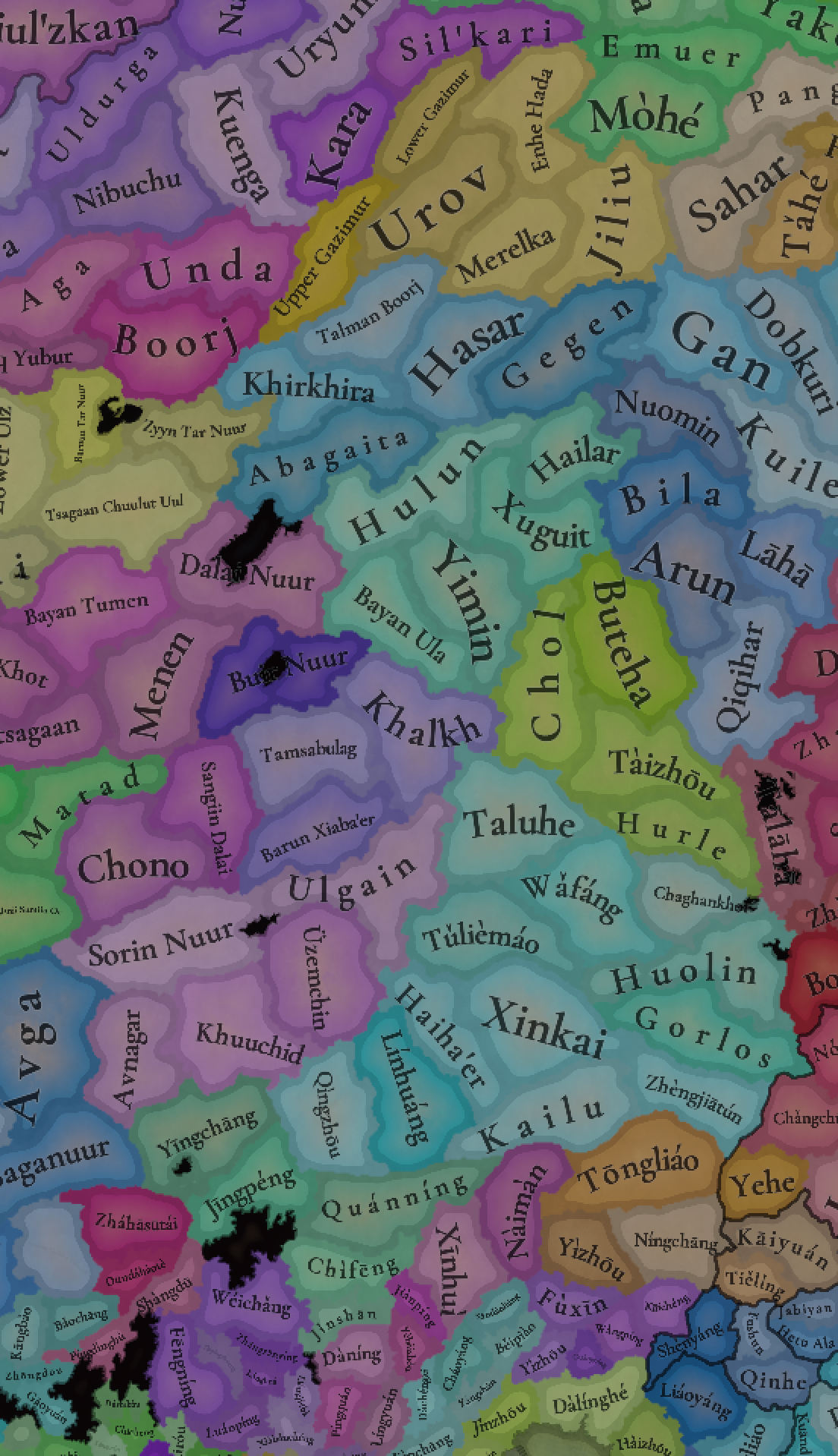
Note that the Juxeri location, if it keeps that name, should be changed to Jušeli to keep consistent wth Möllendorff

Suggestions on Manchuria and the Jurchens (part 3):

Heilongjiang:


View attachment 1202987

Culture:
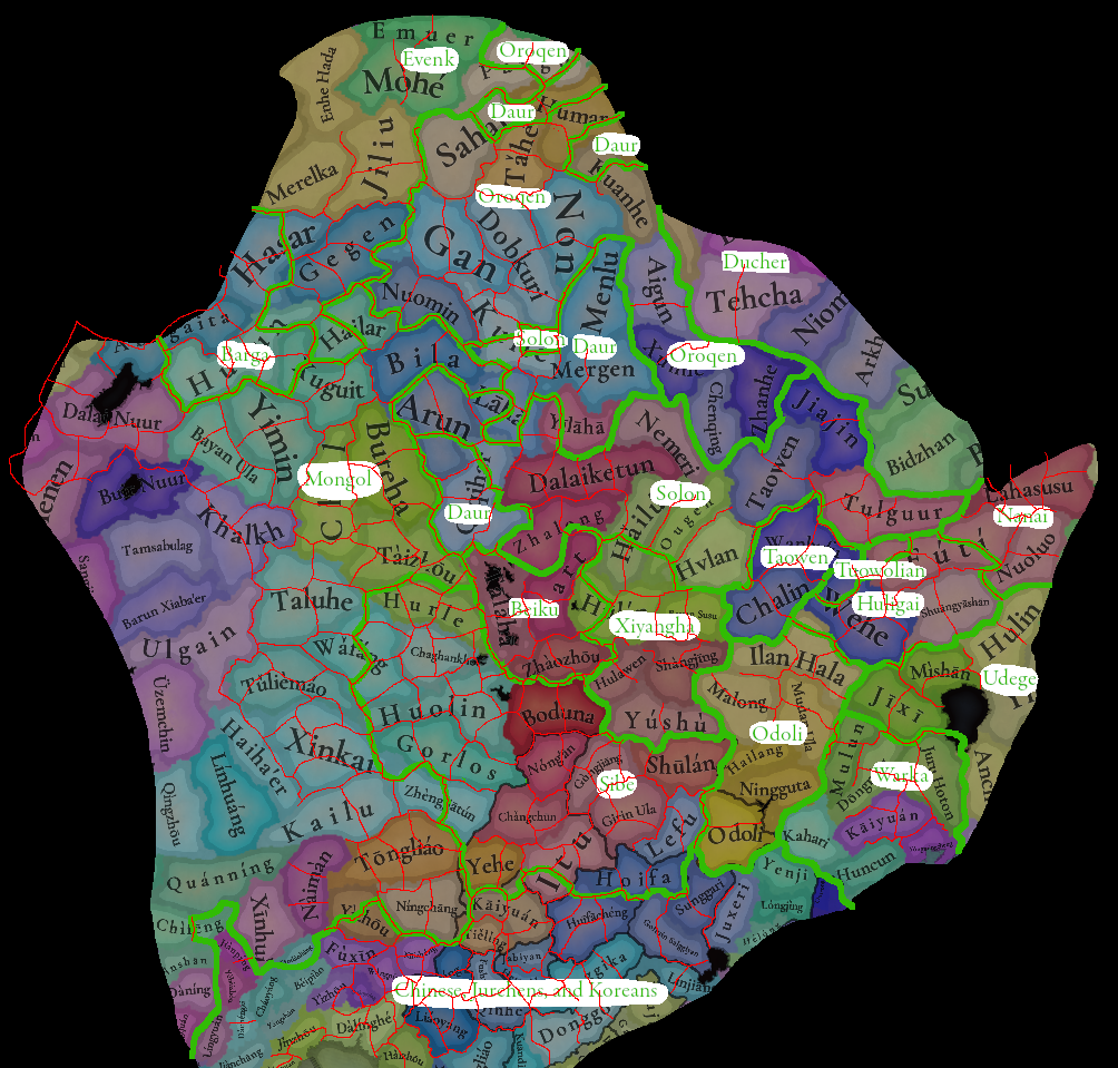
The Sibe seem to be located too far west. From what I can tell, before the Ming dynasty, the areas of Panshi, Huadian, Yitong, and parts of Changchun and Jilin were all their territories. Later part of the Xibe broke away to form what would become the Haixi Jurchens. During the Ming dynasty, it's said that the Sibe lived along the lower reaches of the Nenjiang, the middle and upper reaches of the Songhua, and the Taoer River, and were centred around Boduna. Either of these descriptions would be at odds with their placement in the game, where they seem to inhabit the Greater Khingan Mountains, and the area they inhabited is considered Jurchen and Solon territory.

Additionally, the Sibe were referred to as the "Sibe state" during the Jin, Yuan, and Ming periods, so they should probably be an actual tag instead of a society of pops. It doesn't seem like they were any less of a state than the other Jurchen tribes.

I would also argue that the Sibe should be considered culturally Jurchen. The Haixi Jurchens have a common origin with the Sibe, and the Sibe really only become separated from the rest of the culture because they came to associate with the Mongols, and remained outside Nurhaci's confederation which formed the basis for the Manchu ethnic group, leading to them being considered a distinct people today. Essentially, one way to interpret this could be to say that the Manchu and Sibe are both daughter ethnic groups of the Jurchens.

In general, the Solon and Daur are shifted too far west as well, and should extend into territory the game currently depicts as majority Nanai. Additionally, the game lacks the existence of the Ducher people, related to the Jurchens, who appeared after the collapse of Jurchen Jin.

Tags:
The Xīyánghā 西阳哈 tribe (Manchu transcription of the Chinese name would be *Siyangha) of the Jurchens exists in what is now the Harbin region, both north and south of Songhua. They were destroyed by Ming in 1395

My best attempt to put together a culture/tag map (borders between the Solon, Daur, and Oroqen were seemingly very fluid so these are pretty rough guidelines):

View attachment 1203154

View attachment 1203156

Locations:
66. Bodune is a large location that could be split up. Bodune proper is located in the western half. The eastern half is today known as Fuyu county. This name comes from the ancient Fuyu people who were settled here, so it has a long history of connection to this place. During the Qing dynasty, Boduna New City was established here. This was also the location of the Liao dynasty prefecture Níngjiāngzhōu 宁江州 So this location could either be called Fúyú 扶余, Níngjiāng, or Bódūnà Xīnchéng 伯都納新城). During the Ming dynasty, the Fúyú 扶余 Uriankhai Guard existed. I am not sure exactly what its location is. It is somewhere in the lower reaches of the Nenjiang river, it is also mentioned as being in the Qiqihar region, but could also be here.
67. Dabusu (大布苏) is an old Mongol placename in Qian'an. "Huolin" is the name of a city that is actually in the Tuliemao location and shouldn't be used for this location. I will cover that region in a later post.
68. Haolibao (好力保) is another old Mongol placename
69. Ulantuga (乌兰图嘎) is the name of a Mongol town in Qian Gorlos county
70. Haiqing (海青) is the only placename with a Mongol origin I could find in Changling county, although it's not any older than the 19th century. Changling county itself is named after a geographical feature so its name might be appropriate.
71. Yushu was known as Gūyúshùtún 孤榆树屯 (Manchu would be *Guyušutun) before becoming a county.
72. Túntǎhǔ 屯塔虎 (could also be called Túntǎhǔchéng 屯塔虎城) was the capital city of Changchun county during the Liao dynasty
73. Chaghanhot
74. Chéngsìjiāzi 城四家子
75. Old Mongol name of Taonan is 沙吉盖毛都 Shājígàimáodōu
76. Hatuqi (old Mongol name)
77. Momoge (old Mongol name)
78. Ānguǎng 安广 is a name that dates from the Liao dynasty and is still used today
79. Zalai 大赉 is a Mongol placename, and the name of a banner during the Qing dynasty
80. Baolawendu 包拉温都 is a Mongol placename
81. Qiqihar should be renamed to Cicihar to keep consistent with Möllendorff. However, it should be noted that it only acquired that name in 1691, and previously it was known as Bukui 卜奎, from a Daur word. During the Ming dynasty, the Fúyú 扶余 Uriankhai Guard existed. I am not sure exactly what its location is. It is somewhere in the lower reaches of the Nenjiang river, it could be located here, or somewhere nearby.
82. Misile 梅里斯, Daur placename. This area was inhabited by the Daur and Solon people.
83. Gaqikan Huodure 嘎齐堪霍都热, Daur placename.
84. Present day Yi'an county used to be the capital of the Yikemingan 依克明安 tribe.
85. Tailaiqitun 泰来气屯, from which comes the name of Tailai county
86. Dalaiketun 大来克屯
87. Kalkartu, old Mongol placename from Keshan (though during the Qing dynasty this was not Mongol territory)
88. Babaibulak, Mongol etymology of Baiquan (though during the Qing dynasty this was not Mongol territory)
89. Yangshu (today 兴旺) is an old Solon village
90. Bailu 百露 is an old Solon village, today 今百路村
91. It doesn't really make sense for Shangjing to still be called that since it was totally destroyed and isn't the capital of anything any more. It should probably either be called Huìníng 会宁 (Manchu would be *Huining) or Alcuka (its Qing period name).
92. "Hulawen" is a possible predecessor of the word Harbin, but it's disputed, honestly it would probably just be best to call it Harbin (the Manchu spelling is identical to English)
93. Modern Shuangcheng district is named after Bùdá 布达 and Dáhé 达河, two cities that existed here during Jurchen Jin. I don't know exactly where each one was, but it should probably be possible to find out
94. Dàluólèmì 大罗勒密 is a transliteration of an old Manchu name for a place in Fangzheng county. I can't figure out what it is exactly (direct Manchu transcription is *Dailuwolomi). This location's trade good should probably be lumber. Ilan Hala is a very large location and it is needed to break it up
95. Bin 宾 has been in use as a placename since Jurchen Jin.
96. Mulanda, today's Mulan county is named after the river
97. Chonggulku was the name of a Manchu settlement that give rise to Tonghe county. The current in-game name, Chàlín 岔林, dates to the Qianlong period and might also be fine.
98. Mayan is the Manchu name of a river in Yanshou
99. Shangzhi was originally named Zhūhé 珠河, a transcription of the Manchu world Nicuhe, which means "pearl".
100. Lalin is a Manchu placename in Wuchang
101. Suihua comes from the Manchu word 'Suiha'
102. The Manchu name for Hailun is just Hailun (with no accent marks). It means "otter" in Manchu
103. Hvlan (Hūlan in Möllendorff) is the same name as Hulan, both referring to the river. Tieli was originally known as Tiěshān 铁山 during the Qing dynasty, this name can probably be used for this location.
104. Shírén 石人, for Qinggang county. There are some Jurchen Jin tombs here.
105. Suiling comes from the Manchu word 'Suilan'
106. Anda's name comes from Jida, which is Mongol
107. Guru 古龙
108. Gucha 古恰
109. Talaha's Manchu name is Talahayag
110. From what I could find, Mishan is a rather recent name. Bita (Péidé 裴德) is a Manchu placename here
111. Kuitun Bira (today 当壁) is another Manchu placename in Mishan.
112. Hulin is named from a river, whose Manchu name is Cifuri Niyehe
113. Abuci Bira (阿布沁河) is the name of the river that 阿北乡 is named for
114. Boli
115. Burhatung is a Manchu placename in Linkou county
116. Bózhōu 渤州 is a prefecture that existed during the Bohai and Liao dynasties. The modern town of Gucheng in Linkou is named after it.
117. Giyamusi
118. Shuǐdádá 水達達 (Manchu transcription would be *Šuidada) is a Yuan dynasty circuit whose capital was located in what is now Tangyuan county
119. Yuèlǐdǔ 越里笃 (Manchu transcription would be *Yuwelidu) is the name of a Jurchen tribe that inhabited this region during the Liao dynasty. Right now it would be territory of the Huligai tribe. I don't know where "Wehe" comes from. There is a river here called 倭肯河, that's the closest thing I could find.
120. The old Nanai toponym for Raohe is Noro Bira
121. The old name of Fuyuan county is the Nanai word 'Iliga'
122. Bira Hoo Seme (别拉洪) is an old Manchu placename in Fuyuan.
123. Gaijin 街津口乡 is a Nanai placename in Tongjiang
124. Bachen 八岔乡is a Nanai placename in Tongjiang
125. Jixian county's name comes from the Manchu word 'Gihi'.
126. Baoqing county's name comes from the Manchu word 'Bocihe'
127. Shuangyashan's Manchu name is Juru Niyehe Alin
128. 大佳河乡 and 小佳河镇 in Raohe both get their names from a Manchu word 佳气, which I think is 'Jajin'
129. Hegang's name cames from the Manchu word 'Horigan'. The territory of Hegang city seems to have been inhabited by the Daur and Solon before Qing. I couldn't figure out where "Tulgūr" comes from.
130. Tuōlún 脱伦, Ming era outpost on 都鲁河
131. Wǔtún 五屯, Ming era outpost on 梧桐河
132. Jídá 集达, Ming era outpost on 鸭蛋河
133. Yichun's name comes from the name of a river, so it's probably okay as a location name. Tieli is a old placename from Bohai period, but its actual centre was close to Ilan Hala, so it can't be used.
134. Jiāyīn's name comes from the Manchu word Jaya. Modern Jiayin county was the territory of the Daur or Solon during these times.
135. Ulaga 乌拉嘎's name is Solon in origin
136. Taowen
137. Aigun's Manchu name is Aihūn. This place was originally inhabited by the Ducher ethnic group.
138. Wànhùfǔ 萬戶府
139. Ilha (Daur etymology)
140. Kēluòěr 科洛尔 is the Manchu etymology of Keluo town, Nenjiang city. I cannot figure out what word exactly is being transcribed. The transcription into Manchu would be *Kolor)
141. Huòlóngmén 霍龙门 has a Daur etymology
142. Mergen (modern Nenjiang City)
143. Xunke's name comes from Qíkètètún 奇克特屯, which is Oroqen etymology
144. The Manchu etymology of 逊河镇 is 'Sun Bira'
145. Chele 车勒 is the Oroqen etymolgy of 新鄂
146. Púyǔ 蒲与, a Jurchen Jin circuit.
147. Nancha is named after a river 南岔, whose etymology I do not know
148. Wōjíkūnhé 窝集昆河 is a Ming era outpost
149. Kuren 库仁 is the Evenk etymology for 古莲镇 in Mohe county
150. Mùhé 木河 is Ming era outpost in Mohe (I don't know exactly where in the county it is)
151. Tahe was known as Taha durng the Ming dynasty, there was an outpost there, and its name is either an Oroqen, Daur, or Mongol etymology
152. Waragan 瓦拉干镇 has an Evenk etymology
153. Kaikukang 开库康乡 has an Oroqen etymology
154. Pangu is a Ming era outpost
155. Yīxīkěn 依西肯乡 has an Oroqen or Daur etymology
156. Baiyinna 白银纳 has an Oroqen etymology
157. Humar
158. Jagdaqi 加格达奇 has an Oroqen etymology
159. 小扬气镇 is named for the Yángqì river 扬气
160. Dawusu 大乌苏镇 has an Oroqen etymologu
161. Mageda
162. Targen 塔尔根镇 has an Oroqen etymology
163. Hūcìwēnjiāng 忽刺温江 is a 14th century placename for Hūlan
164. Fǔdámíjiù 甫答迷旧 is a 14th century city at 鸟河乡, in Bin county

View attachment 1203148
Modifications to Heilongjiang:
81. The Jurchen Jin era name of Qiqihar is Pánggé 庞葛城, so it might be better to rename it that
118. This is the capital of 桃温军民万户府, a Yuan dynasty military administrative unit. This location should therefore be called Táowēn. The Manchu etymology of it might be 'Ulden', but I am not sure. It seems possible to me that the Tuowen tribe of Jurchens is the same as this, but I'm not sure.
119. Ǒuhǎnhé 呕罕河 is a Ming era outpost on the river today called Woken
138. Shuǐdádá 水達達
136. Taowen's name is the same as 118, and both refer to the same river. 136 could therefore be renamed to Fēnglín 丰林, the name of another river there. The river's name is probably of recent origin though.
166. Wòduǒlián 斡朵怜 (probably equivalent to the Odoli tribe) is another Yuan tumen. This location would be the capital of Odoli. Located in modern Madacun, Yilan
167. Ilan Hala
168. Tuōwòlián 脱斡怜 is another Yuan tumen. Mongol name is Togolin. This would be located at Wanlihetong, Huachuan county. An alternative theory is that it is located near the mouth of the 多林河 in the lower reaches of the Amur, but this placename seems to have fallen out of use since the Qing era and I cannot find where it would be. I cannot find any references to this name other than to the tumen itself, so I'm not sure if it should be a tag or not.
167. Lahasusu
169. Bayan Susu
170. Zhàozhōu
171. Sartu
172. Zhālóng
173. Futi
174. Bèikǔjiāng 孛苦江 is another tumen. It could either be located in the Qiqihar area, or in the southwest of I cannot find any references to this name other than to the tumen itself, so I'm not sure if it should be a tag or not.
175 and 137. Aigun was originally located on the north bank of the Amur before 1685. Therefore my suggestion is to rename the current Aigun location "Sahaliyan Ula" (Hēilóngjiāng 黑龙江 in Chinese), and created a new location called Aytyun (Aigun) on the north bank of the Amur, out of the Techa location.

Screenshot 2024-10-17 at 15.14.20.png


Suggestions on Manchuria and the Jurchens (part 4):

Mongolian Edge:


Screenshot 2024-10-17 at 15.15.18.png


Locations:
176. The old Mongol name of Tongliao is "Bayisingtu". "Tongliao" I believe is a very modern name and only dates to 1914, although it is in reference to the geography so it's not entirely arbitrary.
177. Melkhiit / 木里图镇
178. Delen / 大林镇
179. 保康镇's original Mongol name is Yamotai 牙莫台
180. Shyeevert / 舍伯吐
181. Jargalang / 吉尔嘎朗镇
182. Chuluu / 朝鲁吐镇
183. 爱民 Àimín is a county that existed during the Liao dynasty
184. Kailu county was only named in 1908 and its name is inappropriate for anytime before the 19th century. 小街基镇's older Mongol name is Khar Mod.
185. Hure banner's name dates from the early Qing dynasty, but I can't find anything else older
186. Naiman is an ancient place-name
187. Sharkhooloi / 沙日浩来镇
188. Baishint / 八仙筒镇
189. Xinkai location's name seems to refer to a river that is not actually in this location. Zürkh 巨日合镇 is a Mongol placename here
190. Khonkh is the Mongol etymology of 黄花山镇
191. Gakhait / 嘎亥图镇
192. Ulaanakhta / 乌兰哈达苏木
193. Chavgaat / 查布嘎图苏木
194. Holingol (could simply be called Holin)
195. Ulanhot's name is quite recent, and its name before that, its name Wangin Süm originated in 1691. Neither of these names can therefore be used. 归流河 is the name of the river there, which comes from the Mongolian 'Güil'
196. Tashjee / 大石寨镇
197. Erkht / 额尔格图镇
198. Tokhom 桃合木苏木 is a Mongol placename said to date from the time of Chinggis Khan
199. Arxan's name comes from 'Khaluun Rashaan', meaning hot spring.
200. Teliemaodu's Mongol name is Dölgöömt
201. Emtiin Gol / 额木庭高勒苏木
202. Taizhou was changed to Tàiníng 泰宁 during Yuan, and retained this name during Ming. Located at modern 塔子城镇
203. Temeej / 图牧吉镇 (named after a river)
204. Hurle's Mongol name is Khürel
205. Bayanölgan / 巴彦乌兰苏木
206. I suspect Wafang 瓦房 is a rather modern name. A better choice might be 野马乡, which comes from the Mongol word 野马图山 (supposedly this means "Zeren", a species of antelope, but it does not sound much like it, so I am not sure what the Mongol word being transcribed is), which is the name of a geographical feature.
207. Döchiovan / 突泉镇
208. Jiānhé 坚河 is a Ming era outpost on the Genhe river.
209. Hēishāntóu 黑山头 is a Yuan dynasty town that was the capital of the Mongol fief in the Hulunbuir region
210. Olguya
211. Giin Gye 金河镇 comes from an Evenk placename
212. Alunshin 阿龙山 comes from an Evenk placename
213. Tel'bor 得耳布尔 comes from an Evenk placename
214. Mangüi 满归
215. Shan Kü Li 上库力 comes from an Evenk placename
216. Mordoo 莫尔道嘎 comes from an Evenk placename. I assume Merelka is a river, but I can't find it
217. Enkh Khad 恩和哈达 is a Mongol placename
218. Lavtalin 拉布大林 is a Mongol placename. The region of modern day Ergun city has the Argun wetlands around the Argun river.
219. Khar Uulyn Tolgoi 黑山头 is a Mongol placename
220. Chichan 奇乾 is named after some rivers. Enhe Hada is actually located at 217, not over here.
221. Hailar is a Ming era outpost. I'm not sure why it has been placed in Yakeshi, I'm pretty sure the Ming outpost was in modern Hailar district.
222. Arun is a Ming era outpost. Its name is probably Daur in origin, from the word Arin. It could also be Evenk, and the capital town today has an Evenk in origin name.
223. Delkir 得力其尔 is an Evenk placename.
224. Saalbasi 查巴奇 is an Evenk placename
225. Morin Dawa is an old Daur placename
226. Dular 杜拉尔, an Evenk name
227. Bayn 巴彦, an Evenk name
228. Hangurg 汉古尔河, Evenk etymology
229. Taban Oboo 塔温敖宝, Mongol placename
230. Hadayan 哈达阳, Daur placename
231. Kuil Huarg 奎勒河, Daur placename
232. Dentka 登特科, Daur placename
233. Aali Biraa 阿里河, Oroqen placename
234. Gaan Dɔɔn 甘河, Oroqen placename
235. Zhven (Mongol) 吉文 (Chinese), Oroqen placename
236. Ölövtei (Mongol) 乌鲁布铁 (Chinese), Oroqen placename
237. Il (Mongol) 宜里 (Chinese), Oroqen placename
238. Ke I (Mongol) 克一河 (Chinese), Oroqen placename
239. Bayan Tsagaanl 巴彦嵯岗, named after a mountain. Note that that Evenk autonomous banner only exists because some of them were garrisoned there by Qing in 1732, in the 14th century it would probably just be Mongol land.
240. The Barga Mongols have lived here for a very long time. This was the site of the Tang dynasty outpost Yōulíng 幽陵 which governed the Barga, and there is a lake here named Hoh Nuur. So it could either be called Barga, Yōulíng, or Hoh Nuur.
241. Bor Shil 宝日希勒, Mongol placename
242. Biyeen Güiriya 巴彦库仁, Mongol placename
243. Hāláhái 哈剌孩 is a Ming dynasty outpost in what is now New Barga Left Banner
244. Övörbulag 乌布尔宝力格 is a Mongol placename
245. Khandgai 罕达盖 is a Mongol placename
246. Javkhlant 吉布胡郎图 is a Mongol placename
247. Erchimtei Bulgiin Us is the old Mongol name of Manzhouli
248. Altan Emel 阿拉坦额莫勒 supposedly is a Mongol placename that dates back to Chinggis Khan
249. Dalai Nuur
250. Kherlün 克尔伦 is a Mongol placename, named for the river
251. Bogdnantuul 宝格德乌拉 is a Mongol placename
252. Xuguit
253. Bood 博克图 is a Mongol placename
254. Ürchkhan (Mongol) 乌尔其汉 (Chinese) is an Oroqen placename
255. Khödör 库都尔 is a Mongol placename
256. Önör 乌奴耳 is a Mongol placename. Zhǐermán 只儿蛮 is a Ming era outpost on the Hailar river. I don't know exactly where it is.
257. There was a Ming military outpost named Ruǎnlǐhé 阮里河 located along what is today the 即雅鲁河 in Zalantun
258. Duǒyán 朵颜 is a Ming military outpost on the Chuoer river.
259. Butha 布特哈
260. Mööch (Mongol) 蘑菇气 (Chinese) is an Evenk placename
261. Khoroo Uul 浩饶山 is a Mongol placename
262. Tsai Gye 柴河 is from an Oroqen placename
263. Bailan 白狼 is a Mongol placename
264. Tóngchāng 同昌
265. Háozhu 豪州. Manchu transcription would be *Hooju
266. Guìdé 貴德 (later became Fushun) Manchu transcription would be *Guido
267. Chaoyang did not recieve that name until 1778. It should be named Xīngzhōng 兴中. Manchu transcription would be *Cooyang. Abandoned during the early Ming dynasty and became Uriankhai Mongol land.
268. Lǘyáng 闾阳 county. Abandoned during the early Ming dynasty. Manchu transcription would be *Lioiyang
269. Fùshù 富庶县. Abandoned during the early Ming dynasty and became Uriankhai Mongol land. Located in Gongyingzi Town.
270. Lingyuan county did not recieve that name until 1914. During Yuan it was known as Hézhòng 和众县. Abandoned during the early Ming dynasty and became Uriankhai Mongol land.
271. There was a Wàngpíng county 望平县 during Yuan, I think it was located in Qiandangbao, Xinmin county, but I am not entirely sure. Abandoned during the early Ming dynasty and became Uriankhai Mongol land.
272. There was a Jīnyuán county 金源县 during Yuan located in Kalaqinzhen. This region shouldn't be called Jianping since that county was only established in 1904. Jinyuan was abandoned during the early Ming dynasty and became Uriankhai Mongol land.
273. There was a Huìhé county 望平县 during Yuan located in Huizhoucun, Jianping. Abandoned during the early Ming dynasty and became Uriankhai Mongol land.
There was also a Wǔpíng 武平县 county during Yuan in Inner Mongolia but I was unable to locate it. Same with Lìzhōu 利州.
274. The prefecture of Gāozhōu 高州 existed during Yuan in what is today Fengshuigou town, Chifeng. Could also be called Sānhán 三韩县. Abandoned during the early Ming dynasty and became Uriankhai Mongol land.
275. Chuānzhōu 川州 existed during Yuan times in what is today the northeastern part of Beipiao. It should probably replace Beipiao, since Beipiao's name is connected to the 20th century coal mining industry. Abandoned during the early Ming dynasty and became Uriankhai Mongol land.
276. There was a 塔海府 during Yuan under Kaiyuan Circuit but I was unable to locate it.
277. Zhangwu was known as the Suruk grassland before colonisation. The counties here were abolished after Jurchen Jin
Qìngyún county 庆云县 was converted into a fort in the Ming dynasty. In earlier times it was on the west bank of the Liao river, but during the game time period it was located on the east bank in Qingyunpu
278. Shuāngchéng county 双城县. I couldn't figure out what Ningchang is.

Screenshot 2024-10-18 at 05.28.16.png


Cultures and tags (version 2)

1732694824744.png


1732694832586.png


Army-Based countries (all of these are culturally Jurchen):
Sibe
Huligai
Warka (maybe)
Taowen 桃温
Tuowolian 脱斡怜
Odoli
Yehe
Xiyangha
Beiku (孛苦江)

Societies of pops:
Daur
Nanai
Udege
Warka (maybe)
Oroqen
Barga
Evenk
Ducher (personally I believe that the Duchers should be Jurchen culture, while being a geographically separate SOP, just like the Warka currently are)

I'm not entirely sure about what goes in the question mark, it might be Sibe territory, or it might be owned by Yuan directly. It might also have Chinese minorities but I'm not sure.

The Tuowolian are a bit small, so if not enough new locations are added as in my proposal, give them the one location of Futi.

Provinces:

Screenshot 2024-10-18 at 06.33.07.png


Areas:

Screenshot 2024-10-18 at 06.33.53.png


Trade Goods:

In general I think "Inner Manchuria" should have more lumber and wild game. The horse goods currently present are probably fine, so that means it will be the other goods being changed. Manchuria is a huge lumber producing region and during the Qing dynasty it was used by the emperors for hunting (although that partly involved intentionally depopulating it).

Terrain:

There should be wetlands along the Argun river, and in the lower Nenjiang area (the game literally has a location named after a wetland preserve that not wetland terrain...), and in general I think Manchuria should have more forests.

This map illustrates the extent of forests in Manchuria at the beginning of the 20th century

Screenshot 2024-10-18 at 06.42.25.png


Suggested added forest marked in bright green

Screenshot 2024-10-18 at 06.50.02.png


Suggested added wetland (the other terrain types will have to wait for later/someone else). Source is mostly SulphurAeon

Screenshot 2024-11-27 at 02.00.12.png


I think these regions should be changed to Arctic climate, as per SulphurAeon's map. This aligns quite well with how I do not think there were any significant settlements located in the region marked until modern times.

1732832297267.png


1732832308554.png
 
Last edited:
  • 15Like
  • 4
  • 2
Reactions:
By the way, the Yakutsk sea should definitely not be disconnected from itself like that. It will produce awkward results during exploration for example (eg, if someone haven't discovered Kamchatka or the Ezo sea which connect the two parts but discover the Yakutsk sea, what will happen? It is going to be rather awkward)
 
  • 2Like
  • 1
Reactions:
By the way, the Yakutsk sea should definitely not be disconnected from itself like that. It will produce awkward results during exploration for example (eg, if someone haven't discovered Kamchatka or the Ezo sea which connect the two parts but discover the Yakutsk sea, what will happen? It is going to be rather awkward)
It should be split and named properly.
The western part is the Sea of Okhotsk, the eastern part is the Bering Sea.
Though the name is anachronistic, given that Vitus Bering wasn't born for 344 more years. But all the Russian language names would be anachronistic in Siberia anyway.
 
  • 1Like
Reactions:
Additional locations on the Ussuri and Amur:

Many people are complaining about the location density of Manchuria, so here is a proposal to add a few more in the places where the Udihe, Nanai, and Nivkh live. Keep in mind that there isn’t much information that I can access prior to 1770 (there also isn’t much information in general before then with regards to locations), so do feel free to criticize any additions made. The majority of the density added will be around the Ussuri river as well as directly south of the Amur, as that is where most people lived and where most of the maps actually recorded. Outside of those areas I will largely base the names off of small rivers or natural landmarks if they have a recorded Tungusic or Chinese name prior to Russian arrival. The borders I drew are sloppy, but the locations that exist usually exist in the middle of them (+- the Amur and Ussuri, as if they lie upon either of those rivers then the settlement directly borders the river).

weeee.png


Locations Based on Old Translations that Survived Sovietization:
  1. Khalaza, older Tungusic name for mount Obzornaya
  2. Lefou, older Chinese? name for the ilistaya river
  3. Pidan, older Tungusic name for mount livadiyskaya
  4. Sungacha, small river that maintained its Tungusic name

Locations Based on Old Maps:

5. Tondon, a river (1758) and (large) settlement (1770) that appears on nearly every map I could find.
6. Noro, a river (1758) and settlement that appears on nearly every map I could find.
7. Mangachan, appears in 1770 as a large settlement (appears on two separate independently published maps, one a year later), then disappears by 1784. I am assuming that it was destroyed by the Russian army in between then given its location (on the northern side of the amur) and the fact that in between those time frames Russian conquest of the far east was occurring.
8. Tai/Tay, appears in 1770 and continues to exist as a large settlement until at least 1851
9. Kalar, appears in 1770 and continues to exist as a large settlement until at least 1851
10. Checkteli/Chelcheli/Teliecheli, appears in 1770 and continues to exist as a settlement until 1784, where it then appears to take the name Charcule/Chulgue until at least 1851
11. Holon, appears as a settlement in 1770, exists until at least 1814, and then is no longer present by 1834
12. Choulgue, appears to exist as a significant settlement in 1770, presumably declines but remains to exist even in 1851
13. Tectenghi, appears to have existed as a small settlement in 1770, appears consistently until 1834
14. Abderi, large settlement in 1770, continues to exist up until 1834 where it then no longer appears
15. Fudali, settlement in 1770, exists consistently until at least 1851
16. Kitin/Kiltji, settlement in 1770, exists consistently until at least 1851
17. Pojuru, settlement in 1770, renamed to Filouha and exists consistently until at least 1851

Rename:

18. Tulazi to Tulamu, Tulazi is the French transliteration while Tulamu is the English one

Edit:
19. Helu, settlment which shows up on basically every map present under some name (usually helu, hetu, or edou) (also may show up on the opposite side of the Amur in older maps)
20. Oanlin, shows up on most maps as a significant settlement
21. Chicduha, shows up varyingly throughout the maps as a settlement. If you don't want Chicduha (for some reason), then go with the smaller settlement just upstream in Fiursu.

Potential Impassable:
  1. While the mountains in primorsky krai aren’t the highest, they are certainly formidable. The highest of these ranges is Sikhote-Alin with peaks over 2,000 meters. If it isn’t given as an impassible, it could easily be a location as Sikhote-Alin is a pre-russian name for the range.

Maps Used:
https://www.raremaps.com/gallery/de...phique-contenant-le-royaume-de-siberie-lotter (french, 1770)
https://www.raremaps.com/gallery/de...rtes-faites-par-des-vaisseaux-russ-muller-rey (french, 1758)
https://www.raremaps.com/gallery/detail/101108/eastern-siberia-sduk (english, 1838)
https://www.raremaps.com/gallery/detail/43243/carte-de-la-tartarie-chinois-1771-bonne (spanish, 1771)
https://www.raremaps.com/gallery/de...malaya-mountains-to-the-arctic-oce-arrowsmith (english, 1834)
https://www.raremaps.com/gallery/de...phica-generalis-imperii-russici-ad-nor-lotter (latin, 1784)
https://www.raremaps.com/gallery/de...cean-septentrional-compris-entre-lasie-bellin (french, 1766)
https://www.raremaps.com/gallery/detail/97766/la-tartaria-chinese-1784-show-corea-zatta (spanish, 1784)
https://www.raremaps.com/gallery/de...e-lasie-reduite-de-la-carte-sur-4-feuill-brue (french, 1814)
https://en.wikipedia.org/wiki/Nikol...llis-1851-Tibet-Mongolia-and-Manchuria-NE.jpg (english, 1851)
 
Last edited:
  • 3Like
  • 2
Reactions:
Cultures in Western Mongolia


Oirats
The Oirats originated as one of the "forest peoples" north of the steppes, around lake Khovsgol and Tuva. During the Mongol empire they spread south and west, merging with the old Naimans and Keraites. In the 1400s, the Oirat confederation came to dominate the remnants of the Yuan on the Mongolian plateau, until Dayan Khan asserted the independence of the eastern Mongols. In the 1500s, the Oirats were pushed further west by the Tumed and Khalkha Mongols, whereby they eventually formed the Dzungar and Kalmyk Khanates.

In 1337, they likely would have inhabited the white area in this map:
View attachment 1203402
I've labelled some of their various tribes to better explain and verify their positions.

Ölöts
The Ölöts (Choros, and ancestors to the Dzungars) were the central tribe of the Oirat Confederation in the 1400s, their primary pastures were located north of the Zavkhan river, and towards the Selenge river. After Esen Taishi's death, the tribe was split apart by religious and leadership disputes, part of them migrated to Moghulistan, where a lot of the tribe were murdered by the Muslim Moghulistan khan. They were driven northwest by the Khalkha in the 1500s.

Khoids and Baatuds
The Baatuds were a subgroup of the Khoid. In the 15th/16th century the Khoids were the easternmost Oirat tribe, occupying the areas around the Khangai mountains, near Karakorum, and down to Khara-Khoto. In 1337, they may not have migrated as far as Khara-Khoto yet, but it's mentioned that Altan Khan of the Tumed pushed them out of this area in the 1500s.

Dörböts and Torghuts
They lived along the Black Irtysh river in the 1500s, up to lake Zaysan. The Torghuts were supposedly descended from the Keraites, and if I remember right the Dörböts were a subgroup of Ölöts who split off in the 1400s/1500s.

Khoshuts
Originally a Khorchin (eastern Mongol) tribe. They joined the Oirat confederation in the 1400s and settled around Bechbaliq. Probably not relevant for 1337, but worth including if steppe migrations aren't really simulated.

Altai Uriankhai
They lived in the Altai mountains in the 1500s, and speak an Oirat dialect today, but wikipedia mentions they lived in Liaoyang in the 1300s, and Khovsgol during the Northern Yuan period, so it actually doesn't seem super clear.

Lake Khovsgol
The original location of the Oirats, today still inhabited by the Oirat speaking Darkhad people. It's mentioned that the Khalkha pushed into this area and the border with Tuva in the 1500s, so it seems reasonable for this to be Oirat culture instead of Khalkha (Mongolian)

Moghulistan / Dzungaria
It seems unlikely that Oirats lived as far west as they do in the original culture map, most migration into the region occured during and after the 1500s, and the Ölöts being killed when they went there in the 1400s makes it look even less likely that any Oirats lived there in significant numbers.
View attachment 1203405
As comparison, this map of the Northern Yuan labels the Oirat tribes in Moghulistan with the same names as I've previously mentioned, instead of unique ones. It's hard to draw a line for where exactly the Oirat culture should cut off and the Kyrgyz begin, and I haven't looked into Kyrgyz migrations so I couldn't really say.

Tuvans
In the 1700s, there were Tuvan communities in the Khovd region, and around lake Khovsgol. It's not clear when they first came here, but it's possible they had a long history there, especially around Khovsgol.

Buryats and Bargas
The Buryats and Bargas formed a part of the Oirat confederation. "Khamag" should probably be renamed "Barga", or merged with the Buryat culture, since Khamag was the name of the original eastern Mongol tribe in the 1200s.


Main sources (among others):


I would spread Oirat culture atleast to where the Oirat tribes are located in the 14th (current) century on that map, with plenty of blurred stripes in the West. The Oirats were known for being the ones beyond the Western Altai mountains after all.

I would also add the tribes as playable tags from the start, to allow for the formation of the Oirat Confederacy that would come to dominate Mongolia 70 years later.


Last edited:
  • 3
  • 2Like
  • 2
Reactions:
This is my work-in-progress mod, set in 1363, with the number of provinces in EUIV. I think the tags are closer to the current weird version.
If you're interested, I can translate this map into English for Tinto's reference.
View attachment 1200634
This Mongolian,lmao
 
  • 1
Reactions:


I would spread Oirat culture atleast to where the Oirat tribes are located in the 14th (current) century on that map, with plenty of blurred stripes in the West. The Oirats were known for being the ones beyond the Western Altai mountains after all.

I would also add the tribes as playable tags from the start, to allow for the formation of the Oirat Confederacy that would come to dominate Mongolia 70 years later.


View attachment 1204080View attachment 1204083View attachment 1204084


I think having the tribes be playable from the start would be a great addition, eventual Oirat independence was basically set in stone since the rebellions of Ariq Böke in the 1200s, so it'd nice to have them as loose subjects. The only thing I'm wondering is how to simulate the tribes confederating, because they're currently split between 3 different states.


On the positions of the tribes, I don't think the map is necessarily a reliable source for exact positions in the 14th century, since it's an unsourced map from Wikipedia and looks more like it's supposed to be an overview of the entire Northern Yuan period (especially the situation in the late 16th century) rather than a specific date in the 14th century.

Also, while it's true the Oirats were known for being west of the Altai mountains today, this probably wasn't the case before the 16th century:
Screenshot_20241019-110235~2.png

Screenshot_20241019-112018~3.png


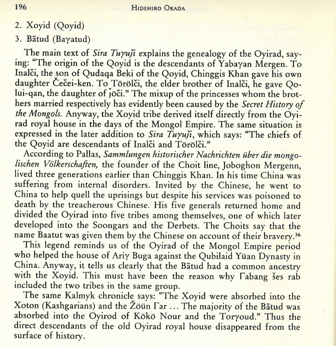
It's kinda difficult to find accurate Oirat history since it's split between lots of secondary sources online, so I'm trying to get my hands on the book "Origins of the Dörben Oyirad" by Hidehiro Okada, which seems to be extremely detailed and the base material of most Oirat studies from the 80s to today. I've contacted a library and should hopefully have access to the book by next week, so I'll come back to this with more details on where each tribe should be situated.
 
  • 3Like
  • 1
Reactions:
I think having the tribes be playable from the start would be a great addition, eventual Oirat independence was basically set in stone since the rebellions of Ariq Böke in the 1200s, so it'd nice to have them as loose subjects. The only thing I'm wondering is how to simulate the tribes confederating, because they're currently split between 3 different states.


On the positions of the tribes, I don't think the map is necessarily a reliable source for exact positions in the 14th century, since it's an unsourced map from Wikipedia and looks more like it's supposed to be an overview of the entire Northern Yuan period (especially the situation in the late 16th century) rather than a specific date in the 14th century.

Also, while it's true the Oirats were known for being west of the Altai mountains today, this probably wasn't the case before the 16th century:
View attachment 1204328
View attachment 1204329

It's kinda difficult to find accurate Oirat history since it's split between lots of secondary sources online, so I'm trying to get my hands on the book "Origins of the Dörben Oyirad" by Hidehiro Okada, which seems to be extremely detailed and the base material of most Oirat studies from the 80s to today. I've contacted a library and should hopefully have access to the book by next week, so I'll come back to this with more details on where each tribe should be situated.
I remember reading in some places that the Oirats at this time lived around the headwaters of the Irtysh river and also controlled the headwaters of Ob and Yenesei (i.e. the regions later known as Altai Uriankhai and Tannu Tuva). Hopefully you can find a good description.
 
  • 1Like
Reactions:
I would like to add that areas like Kamchatka, Chukotka, SIberian Northern coast got insanely many locations, most of them contain only one modern-day village with a couple of dozens of houses and population around 100-500 people. And some of them do not have any life at all.

An example, northern part of Kamchatka coast around Khailino - Pakhaci - Apuka - Achaivayam:
Tiles_Map.png


Only Pakhaci location contains 2 settlements, both are tiny villages with 20-30 houses. Other locations contain either only one village or no signs of life at all:
Tiles.png


The same applies to other areas nerby.

So ~14 times increase (vs EU4) of the number of locations here is really overkill, I think it can be reduced by 2-3 times. So that Kamchatka would have 10-12 locations, not 27.
 
Last edited:
  • 6Like
  • 1
Reactions:
I would like to add that areas like Kamchatka, Chukotka, SIberian Northern coast got insanely many locations, most of them contain only one modern-day village with a couple of dozens of houses and population around 100-500 people. And some of them do not have any life at all.

An example, northern part of Kamchatka coast around Khailino - Pakhaci - Apuka - Achaivayam:
View attachment 1207427

Only Pakhaci location contains 2 settlements, both are tiny villages with 20-30 houses. Other locations contain either only one village or no signs of life at all:
View attachment 1207426

The same applies to other areas nerby.

So ~14 times increase (vs EU4) of the number of locations here is really overkill, I think it can be reduced by 2-3 times. So that Kamchatka would have 10-12 locations, not 27.
Its also worth noting than 1000 pops are necesary for a loc to be colonized in game, so that number of locs might make the area uncolonizable unless Russia gets unique colonization mechanics.
 
  • 2
Reactions:
Its also worth noting than 1000 pops are necesary for a loc to be colonized in game, so that number of locs might make the area uncolonizable unless Russia gets unique colonization mechanics.
I honestly think this could be considered a feature, since Russian settlements in this region in the early modern period were sparse and widely scattered. So having this many locations would naturally recapitulate the real life conditions of most of Siberia being unsettled.
 
I think having the tribes be playable from the start would be a great addition, eventual Oirat independence was basically set in stone since the rebellions of Ariq Böke in the 1200s, so it'd nice to have them as loose subjects. The only thing I'm wondering is how to simulate the tribes confederating, because they're currently split between 3 different states.


On the positions of the tribes, I don't think the map is necessarily a reliable source for exact positions in the 14th century, since it's an unsourced map from Wikipedia and looks more like it's supposed to be an overview of the entire Northern Yuan period (especially the situation in the late 16th century) rather than a specific date in the 14th century.

Also, while it's true the Oirats were known for being west of the Altai mountains today, this probably wasn't the case before the 16th century:
View attachment 1204328
View attachment 1204329

It's kinda difficult to find accurate Oirat history since it's split between lots of secondary sources online, so I'm trying to get my hands on the book "Origins of the Dörben Oyirad" by Hidehiro Okada, which seems to be extremely detailed and the base material of most Oirat studies from the 80s to today. I've contacted a library and should hopefully have access to the book by next week, so I'll come back to this with more details on where each tribe should be situated.


(Beware! Gigantic file size):
View attachment The-Great-Yuan-State-in-1351.png

The above map of Yuan doesn't explicitly state that all the tribes in the West were Oirats, but it would make sense going by what you said and other sources that the Oirats hadn't been driven so far West by 1337. The placement of the individual named Oirat tribes in my map is completely random, but I don't think that's too big of a problem considering their later migrations shuffled them around regardless.

The map also gives other interesting bits, like the remaining Ögedeids existing in the far West, ruling over the Ögedei Ulus rump-state (Melik Ulus) left behind by the Kaidu-Kublai war, after which the remaining Ögedeids submitted to the Yuan. Also the other princely Borjigins in Eastern Mongolia, such as the Belguteids, Hachiunids, Otchigids and especially the Qasarids, whose location would roughly correspond to the later Korchins, who are said to be descended from Qasar.

I would say Mongolia should look something like the image below:

OUTDATED MAP

Countries.png


Locations:
Locations.png


Last edited:
  • 4Like
  • 2
Reactions:
Societies of Pops
View attachment 1197851
And speaking of that, most of them are obviously concentrated in Manchuria and around the borders of the countries and coasts, while the more inhospitable places further into Siberia and Kamchatka are more sparsely populated and thus less organized.

Locations
View attachment 1197853
View attachment 1197851
View attachment 1197853
So, I look at these two pictures and wonder:

Why bother with any locations North from the Sakha and Yukaghir peoples? It was empty wasteland and it is empty wasteland. No countries, no SOPs. The only locations worth considering are Sakha interior and Pacific Coast up to Dezhnev Cape. Anything in between Ob river, Sakha and the Chukchi people should be represented by empty frozen wasteland. At most, it should use the same oasis mechanic as the Sakhara, with snakey connections and the few oaseses being river mouths.
 
  • 1
  • 1Like
Reactions:


(Beware! Gigantic file size):
View attachment 1207805

The above map of Yuan doesn't explicitly state that all the tribes in the West were Oirats, but it would make sense going by what you said and other sources that the Oirats hadn't been driven so far West by 1337. The placement of the individual named Oirat tribes in my map is completely random, but I don't think that's too big of a problem considering their later migrations shuffled them around regardless.

The map also gives other interesting bits, like the remaining Ögedeids existing in the far West, ruling over the Ögedei Ulus rump-state left behind by the Kaidu-Kublai war, after which the remaining Ögedeids submitted to the Yuan. Also the other princely Borjigins in Eastern Mongolia, such as the Belguteids, Hachiunids and especially the Qasarids, whose location would roughly correspond to the later Korchins, who are said to be descended from Qasar.

I would say Mongolia should look something like the image below:

View attachment 1207851

Locations:
View attachment 1207811


I finally got access to the document I was talking about, "Origins of the Dörben Oyirad", it doesn't have any crazy new info but it does have a more consistent and accurate view on the tribes, so I'll make some final revisions below.


Generally speaking, the Oirat tribes can (and probably should) be split into 3 groups, those being the Khoid (old Oirats/Oyirads), the Torghut (Keraites/Kereyids), and the Choros (Naimans). I'll give more information on them below.

Countries~3.png

Rough areas, I doubt it'd be possible to get perfect borders because of the nature of the steppe and their documentation, so whatever works best from a gameplay perspective.

Screenshot_20241101-150317.png

As a note, some of the names are spelt slightly differently here, for example Xoyid is Khoid, Žun Гar is Dzungar, Torγud is Torghut, etc. Also note that "Tümed" here isn't talking about the other Tümed in southern Mongolia, so don't worry about that.


Khoid

The "original" Oirats, or at least the continuation of their royal line from the early Oirats in the Mongol Empire. They had a sub-tribe called the Baatud, and some documents mention more sub-tribes, but it's not exactly clear what role each tribe played or where they were so the safer option would be to just have a singular "Khoid" country (or it could even be called "Oirat", but that might get confusing with the Four Oirat confederation). Their position doesn't really need to move compared to our last posts, they seem to have migrated southwards at some point in the 14th century.

Screenshot_20241102-112501.png


Torghut

Descended from the Keraites of the Mongol Empire, they lived along the Black (Kara) Irtysh river which corresponds to the current "Altay" province in-game. This was confirmed in my last post on Oirat culture, but it's also separately said that the Keraites lived here in the 14th century, so I guess that's further confirmation.

Interestingly, with the Torghuts being descended from the Keraites, it's very possible that they were Nestorian Christians until the destruction of the Karakorum in 1380, which is said to be when the religion died out here. I'm not sure to what extent their population were Nestorian, I can imagine it being a similar situation to Tibetan Buddhism where the leaders converted but the people only nominally followed the religion, causing it to die out when the Yuan fell. Indeed, the Torghut leaders traced their lineage from Toghrul, who came from a Nestorian family, so maybe having it as the state religion with a mostly Tengri population could work. Even if it's technically not confirmed, it seems like a cool addition ;)

Screenshot_20241102-170256.png

Screenshot_20241102-113510~2.png

Screenshot_20241101-152156.png


Choros

Descended from the Naimans of the Mongol Empire. The Naimans in the 13th century mostly lived between the Altai and Khangai mountains, and the Choros in the late 15th century lived on the slopes of the Altai mountains and Zavkhan river, which is essentially the same position. It's possible there were some migrations between those times, like I wonder how specifically the Khoid went from the north of the Naimans/Choros to the south of them, but I'd prioritize their documented positions in the Oirat confederation.

The Choros are the ancestors of the later Dörbet and Dzungars, who started separating from eachother after the 15th century.

"Origins of the Dörben Oyirad" goes into a lengthy segment about why the Choros are related to the Naimans, but I couldn't really fit it all in here. It's just something that seems very likely due to similarities in culture, traditions, and geography.
Screenshot_20241102-174326~2.png

Screenshot_20241101-154721.png

Screenshot_20241102-060739.png

The Dzungars and Dörbets coming from the Choros is also mentioned in Origins of the Dörben Oyirad


Other tribes

- Dörbet, as mentioned above they split from the Choros later, so shouldn't be here

- Baatud, again mentioned above, it's probably not worth representing them as an independent entity from the Khoid

- Bayad, I noticed they weren't mentioned in the document, so I looked into them elsewhere and it seems like they lived around the same area as the Sulduz and didn't migrate towards Altai until later. I'm not sure whether they'd need to be a separate country over there, but probably not
Screenshot_20241101-151817.png


- Ölöts, seem to be either mythical or a designation for multiple tribes in this period, so they can't really be put anywhere as a separate country
Screenshot_20241102-180714.png


- Ögedeids, "Origins of the Dörben Oyirad" mentions them being the Southwest of the Oirats, but I'm not sure if they should actually be present at all. As cool as they could be, some articles mention them already being dispersed from this region. There was briefly an Ögedeid khan of the Northern Yuan later on, so maybe they could be represented through events. It might be worth looking into this state some more

- Kyrgyz, seem to be already represented by the Khongoraian SoP, but they were considered an "early state formation" with a feudal-like system, so they seem to be teetering on the line between SoP and landed state

- Telengits, already represented by the Altaian SoP, but also teetering on the line like Khongorai and were apparently completely independent from the 14th century

- Tuvans, could actually be a good candidate as a SoP, since they didn't really have any independent states but still existed as a people

- Buryats and Barguts, they aligned themselves with the Oirat confederation, I'm not sure if SoP mechanics can similate that. I haven't looked much into their history but maybe they could be appropriate as a landed state too
 
Last edited:
  • 4
Reactions:
I finally got access to the document I was talking about, "Origins of the Dörben Oyirad", it doesn't have any crazy new info but it does have a more consistent and accurate view on the tribes, so I'll make some final revisions below.


Generally speaking, the Oirat tribes can (and probably should) be split into 3 groups, those being the Khoid (old Oirats/Oyirads), the Torghut (Keraites/Kereyids), and the Choros (Naimans). I'll give more information on them below.

View attachment 1210847
Rough areas, I doubt it'd be possible to get perfect borders because of the nature of the steppe and their documentation, so whatever works best from a gameplay perspective.

View attachment 1210837
As a note, some of the names are spelt slightly differently here, for example Xoyid is Khoid, Žun Гar is Dzungar, Torγud is Torghut, etc. Also note that "Tümed" here isn't talking about the other Tümed in southern Mongolia, so don't worry about that.


Khoid

The "original" Oirats, or at least the continuation of their royal line from the early Oirats in the Mongol Empire. They had a sub-tribe called the Baatud, and some documents mention more sub-tribes, but it's not exactly clear what role each tribe played or where they were so the safer option would be to just have a singular "Khoid" country (or it could even be called "Oirat", but that might get confusing with the Four Oirat confederation). Their position doesn't really need to move compared to our last posts, they seem to have migrated southwards at some point in the 14th century.

View attachment 1210853


Torghut

Descended from the Keraites of the Mongol Empire, they lived along the Black (Kara) Irtysh river which corresponds to the current "Altay" province in-game. This was confirmed in my last post on Oirat culture, but it's also separately said that the Keraites lived here in the 14th century, so I guess that's further confirmation.

Interestingly, with the Torghuts being descended from the Keraites, it's very possible that they were Nestorian Christians until the destruction of the Karakorum in 1380, which is said to be when the religion died out here. I'm not sure to what extent their population were Nestorian, I can imagine it being a similar situation to Tibetan Buddhism where the leaders converted but the people only nominally followed the religion, causing it to die out when the Yuan fell. Indeed, the Torghut leaders traced their lineage from Toghrul, who came from a Nestorian family, so maybe having it as the state religion with a mostly Tengri population could work. Even if it's technically not confirmed, it seems like a cool addition ;)

View attachment 1210858
View attachment 1210859
View attachment 1210856


Choros

Descended from the Naimans of the Mongol Empire. The Naimans in the 13th century mostly lived between the Altai and Khangai mountains, and the Choros in the late 15th century lived on the slopes of the Altai mountains and Zavkhan river, which is essentially the same position. It's possible there were some migrations between those times, like I wonder how specifically the Khoid went from the north of the Naimans/Choros to the south of them, but I'd prioritize their documented positions in the Oirat confederation.

The Choros are the ancestors of the later Dörbet and Dzungars, who started separating from eachother after the 15th century.

"Origins of the Dörben Oyirad" goes into a lengthy segment about why the Choros are related to the Naimans, but I couldn't really fit it all in here. It's just something that seems very likely due to similarities in culture, traditions, and geography.
View attachment 1210890
View attachment 1210892
View attachment 1210893
The Dzungars and Dörbets coming from the Choros is also mentioned in Origins of the Dörben Oyirad


Other tribes

- Dörbet, as mentioned above they split from the Choros later, so shouldn't be here

- Baatud, again mentioned above, it's probably not worth representing them as an independent entity from the Khoid

- Bayad, I noticed they weren't mentioned in the document, so I looked into them elsewhere and it seems like they lived around the same area as the Sulduz and didn't migrate towards Altai until later. I'm not sure whether they'd need to be a separate country over there, but probably not
View attachment 1210895

- Ölöts, seem to be either mythical or a designation for multiple tribes in this period, so they can't really be put anywhere as a separate country
View attachment 1210901

- Ögedeids, "Origins of the Dörben Oyirad" mentions them being the Southwest of the Oirats, but I'm not sure if they should actually be present at all. As cool as they could be, some articles mention them already being dispersed from this region. There was briefly an Ögedeid khan of the Northern Yuan later on, so maybe they could be represented through events. It might be worth looking into this state some more

- Kyrgyz, seem to be already represented by the Khongoraian SoP, but they were considered an "early state formation" with a feudal-like system, so they seem to be teetering on the line between SoP and landed state

- Telengits, already represented by the Altaian SoP, but also teetering on the line like Khongorai and were apparently completely independent from the 14th century

- Tuvans, could actually be a good candidate as a SoP, since they didn't really have any independent states but still existed as a people

- Buryats and Barguts, they aligned themselves with the Oirat confederation, I'm not sure if SoP mechanics can similate that. I haven't looked much into their history but maybe they could be appropriate as a landed state too

Regarding the Ögedeids, they were broken up into multiple groups, however the principal tribe, descended from Melik, son of Ögedei, became vassals to the Yuan, holding roughly the lands I have on the map. They were given the title of "Prince of Yangzhai", and would rebel against Yuan in 1360, apparently amassing an army of "hundreds of thousands" before being defeated.

 
  • 3
Reactions: