• We have updated our Community Code of Conduct. Please read through the new rules for the forum that are an integral part of Paradox Interactive’s User Agreement.

Tinto Maps #23 - 18th of October 2024 - China

Hello, and welcome to another week of Tinto’s fun Maps. This week it will be a huge one, as we will take a look at the entirety of China. It is a really big area, but it didn’t make sense to split it into multiple parts to present it separately, so we are showing it all at once. So, without further ado, let’s get started.

Countries
Countries.png
Colored impassables.png

Obviously the territory is dominated by Yuán, with Dali as its vassal. They appear big, strong, and scary, but they will have their own fair share of problems for sure. I will not go into detail into the countries that can be seen further south, as we will talk about Southeast Asia in a future Tinto Maps.

Societies of Pops
SoP.png

Quite a variety of peoples in Southwest China, as you will see later in the culture maps.

Dynasties
Dynasties.png

Here we finally have managed to catch the full name of the Borjigin dynasty in all its glory.

Locations
Locations.png

Locations zoom 1.png

Locations zoom 2.png

Locations zoom 3.png

Locations zoom 4.png

Locations zoom 5.png

Locations zoom 6.png

Locations zoom 7.png

Locations zoom 8.png

Locations zoom 9.png
Before you ask, there are around 1800 locations in China proper, not counting impassables and barring possible counting errors.

Provinces
Provinces.png

Provinces zoom 1.png
Provinces zoom 2.png
Provinces zoom 3.png
Provinces zoom 4.png
Provinces zoom 5.png

Areas
Areas.png


Terrain
Topography.png
Climate.png
Vegetation.png

You will notice here that there are few locations assigned as "farmlands", that's because when we did this part of the map there was yet not a clear criteria on how we would be defining the farmlands and their placement here hasn't been reviewed yet.

Development
Development.png

As mentioned before, the harsh changes of development at the end of China proper is probably too strong right now and it’s something that will have to be reviewed, especially at the Liáodōng area.

Natural Harbors
Natural Harbors.png


Cultures
Cultures.png

Cultures zoom 1.png

Cultures graph.png

There is a lot of cultural variation in China, not only among the sinitic peoples (which have been divided according to their linguistical and dialectal differences) but also having many other types of non-sinitic peoples. The resulting pie chart for the cultures of the country is a wonder to see indeed. And even if Yuán itself is Mongolian, there are actually very few Mongolian people in the country, as only the ruling class would belong to it. That is one other source of further trouble for Yuán.

Religions
Religions.png

Religions zoom.png
Considering religion, there is also a lot of variation in the South West, and one thing you will notice is the clear lack of “Animism”. We have finally eliminated Animism as a religion from the game and have divided it into many multiple ones. Besides this, and some Muslim presence in some areas, there are other small pockets of religions that do not get to appear in the map, like Manichaeism, Nestorianism, Judaism and Zoroastrianism. And the elephant in the room is the Mahayana, that we have already mentioned that we have plans on dividing it, but more on it at the end.

Raw Materials
Raw materials.png

Raw materials zoom 1.png

Raw materials zoom 2.png
Raw materials zoom 3.png
Raw materials zoom 4.png
A very resource rich region, which makes it understandable that China was able to basically be self-sufficient in terms of resources for long periods in history, and with many sources of highly appreciated resources like silk, tea, and even soybeans. Another interesting thing is the division on the preference of grain cultivation, with rice being more prominent in the south while the north tends to favor wheat and sturdy grains (millet, basically).

Markets
Markets.png


Population
Population.png

Population zoom 1.png
Population zoom 2.png
Population zoom 3.png
Population zoom 4.png
Population zoom 5.png
Population zoom 6.png
Population zoom 7.png
Population zoom 8.png
Yes, there’s a lot of population in China, and with that many people and that many resources it obviously has a lot of potential. We have been following population census of 1351 and 1393, which allows us to have the most accurate values we can have.

Now, before closing off, let me turn back once again to the subject of religion, as it has already been pointed out that having a single Mahayana religion covering both China and Tibet (and parts of India) may not be the best both for accuracy and gameplay reasons, and we basically agree with it so we are planning on reworking a bit but it hasn’t been done in time for this Tinto Maps. However, as we are aware that you are not able to provide proper feedback unless we present you something, let me now share with you what are our plans with it. Please keep in mind that I will NOT go into details about their mechanics, and only talk about their distribution.

First of all, Tibetan Buddhism will be split and turned into its own religion. Although it “technically” is part of the Mahayana branch, it is true that its practices have distinguished it from Chinese Buddhism enough to represent it as its own religion, starting from the fact that they do not follow the same canon. The Mahayana that was present in India was already an outlier from start, so it will be made into its own religion.

That leaves out that the current “Mahayana” remaining in game will be Chinese Buddhism, that is, those following the Chinese Buddhist canon, and it will be present in China, Korea, and Vietnam. The question remains on what to call the religion, and several things have to be considered for that:

  1. The religion will already include blended into it Confucianism and Daoism besides Buddhism, so all three religions are included. That means it can’t be named either Confucianism or Daoism, as they have been bundled in. Buddhism was taken as the base name because, from the three, it was considered as the one mostly oriented towards the “religious” (Confucianism being more focused on administration and Daoism on rituals), and the most similar to what an organized religion would be outside of China.
    1. As a subpoint on that, and I can’t go into details for it yet, but there will also be options inside it to favor Buddhism over Confucianism or the opposite, so that is already covered too.
  2. As mentioned, it will be present not only in China but also in Korea and Vietnam (and any other country that may convert too, like for example Japan), so naming it something that’s too intrinsic to Chinese identity would not be ideal. That would mean that a term like Sānjiào, although good, would feel a bit out of place when playing for example as Korea (we know that the concept spread there too, but it was more prominent inside China and regardless having the name be directly in Chinese would be the main issue when playing outside China)

So, for now, the current name we are considering for the religion is directly “Chinese Buddhism”, or even leaving it as “Mahayana”, understanding that the main current of Mahayana is the version following the Chinese canon anyway. But feel free to suggest any alternative naming if you feel that there may be a better option we haven’t thought of, as long as it takes into consideration the previous points. And of course, let us know your feedback on the proposed representation and distribution too.

And that’s it for today, after a bit longer closing than usual. Next week we’ll be back a bit further east, taking a look at Korea and Japan. Hope to see you there!
 
  • 211Like
  • 68Love
  • 10
  • 6
  • 4
Reactions:
First of all, I am satisfied with the level of refinement of loacations of China. And the division and naming of provinces are basically consistent with historical facts. I want to thank the Paradox staff for all their hard work on this. However, I have to point out that there is a huge mistake in locations!

The three types of land divisions in the game should correspond to the three levels of administrative divisions in ancient China as follows:
Area --- [Province] (, It was called 承宣布政使司 in the Ming and Qing dynasties) / (*Province in PRC now)
Province --- [Fu] () / [Zhou] (直隶州) / (*Prefecture-level city in PRC now)
Location --- [County] () / [Zhou] (散州) / (*County in PRC now)

It can be clearly seen that locations are divided based on county-level administrative divisions. So the location should be named after the ancient county name (third-level administrative units). But in reality, most of names of locations are based on modern Chinese names of townships ([subdistrict] (街道) or [town] (镇), fourth-level administrative units) where the county seats are located. This is really ridiculous......XD

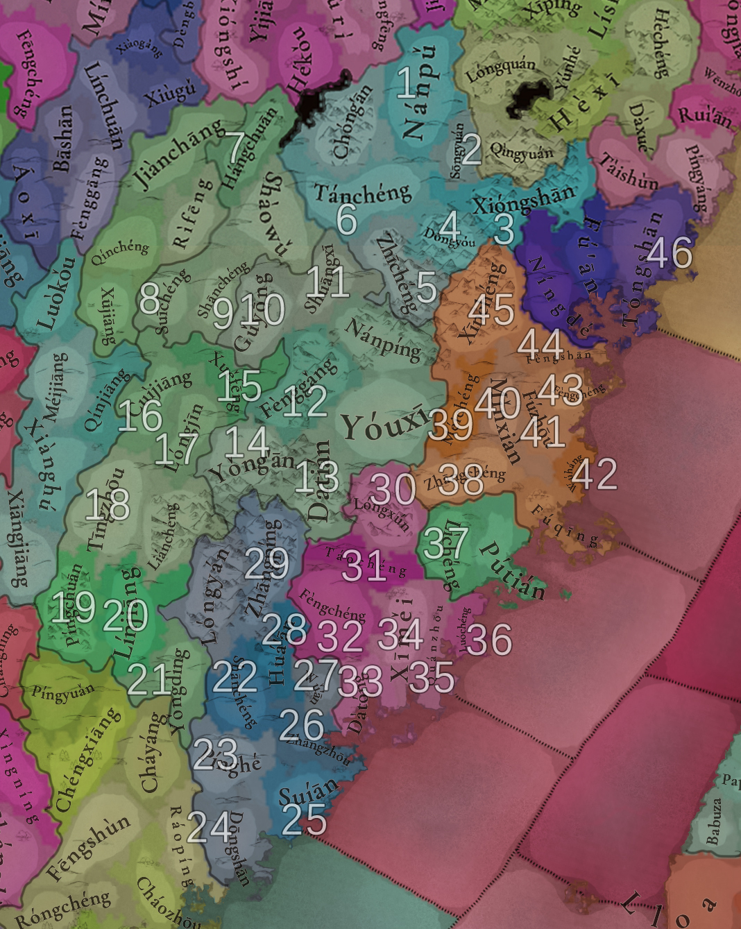
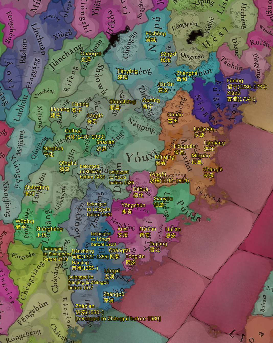
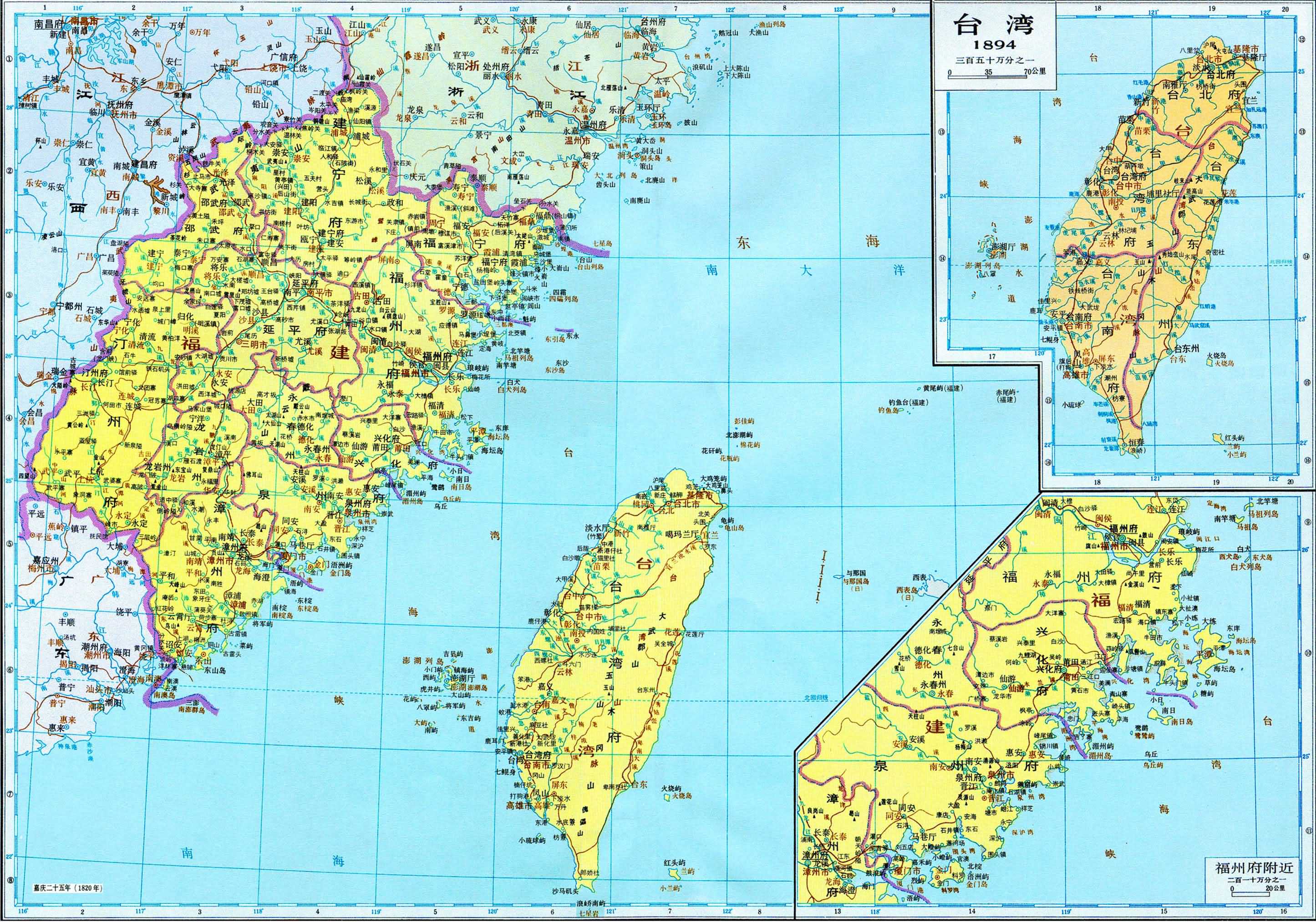
I come from Fujian, so I am familiar with the administrative divisions of Fujian. Based on "The Historical Atlas of China", I have corrected the incorrect location names of Fujian. (Due to my limited personal energy, I only corrected the issues in Fujian. In fact, these issues are present in all provinces of China. It is recommended to find some Chinese people with relevant knowledge to help with the correction.)

-Jiànníng Province [Fu]-
1. Nánpǔ (南浦) subdistrict → Pǔchéng (浦城) county
2. Sōngyuán (松源) subdistrict → Sōngxī (松溪) county
3. Xióngshān (熊山) subdistrict → Zhènghé (政和) county
4. Dōngyóu (东游) town → Jiàn'ān (建安) county
5. Zhīchéng (芝城) townŌuníng (瓯宁) county
PS: Jiànníng (建宁) ancient city (Fu Seat/府治, the administrative center or seat of government of Jiànníng Fu. And it's also the county seat of Ōuníng county) was located at this location [county].
6. Tánchéng (潭城) subdistrict → Jiànyáng (建阳) county

-Shàowǔ Province [Fu]-
7. Hángchuān (杭川) town → Guāngzé (光泽) county
8. Suīchéng (濉城) town → Jiànníng (建宁) county
9. Shānchéng (杉城) town → Tàiníng (泰宁) county
*Shàowǔ (邵武) ancient city was located at Shàowǔ (邵武) location [county].

-Yánpíng Province [Fu]-
10. Gǔyōng (古镛) town → Jiānglè (将乐) county
11. Shuāngxī (双溪) subdistrict → Shùnchāng (顺昌) county
12. Fènggǎng (凤岗) subdistrict → Shāxiàn (沙县, Shā county)
13. Yǒng'ān (永安) belonged to Shāxiàn (沙县) before 1452.
14. Dàtián (大田) belonged to Yóuxī (尤溪) before 1535.
*Yánpíng (延平) ancient city was located at Nánpíng (南平) location [county].

-Tīngzhōu Province [Fu]-
15. Xuěfēng (雪峰) town → Guīhuà (归化) county [1470-1933]
PS: It belonged to Qīngliú (清流) , Nínghuà (宁化) , Jiānglè (将乐) and Shāxiàn (沙县) before 1470.​
16. Cuìjiāng (翠江) town → Nínghuà (宁化) county
17. Lóngjīn (龙津) town → Qīngliú (清流) county
18. Tīngzhōu (汀州) ancient city Chángtīng (长汀) county
PS: Tīngzhōu (汀州) ancient city was located at this location [county].
19. Píngchuān (平川) subdistrict → Wǔpíng (武平) county
20. Línjiāng (临江) town → Shàngháng (上杭) county
21. Yǒngdìng (永定) belonged to Shàngháng (上杭) before 1478.

-Zhāngzhōu Province [Fu]-
22. Shānchéng (山城) town → Nánshèng (南胜) county [1322-1355] & Nánjìng (南靖) county [1355-]
23. Pínghé (平和) belonged to Nánjìng (南靖) & Zhāngpǔ (漳浦) before 1517.
24. Dōngshān (东山) island → Zhào'ān (诏安) county [1530-]
PS: It belonged to Zhāngpǔ (漳浦) before 1530.​
25. Suíān (绥安) town → Zhāngpǔ (漳浦) county
26. Zhāngzhōu (漳州) ancient city Lóngxī (龙溪) county
PS: Zhāngzhōu (漳州) ancient city was located at this location [county].
27. Wǔ'ān (武安) town → Chángtài (长泰) county
28. Huá'ān (华安) belonged to Lóngxī (龙溪) before 1928.
29. Zhāngpíng (漳平) belonged to Lóngyán (龙岩) before 1470.

-Quánzhōu Province [Fu]-
30. Lóngxún (龙浔) town → Déhuà (德化) county
31. Táochéng (桃城) town → Yǒngchūn (永春) county
32. Fèngchéng (凤城) town → Ānxī (安溪) county
33. Dàtóng (大同) subdistrict → Tóng'ān (同安) county
34. Xīměi (溪美) subdistrict → Nán'ān (南安) county
35. Quánzhōu (泉州) ancient city Jìnjiāng (晋江) county
PS: Quánzhōu (泉州) ancient city was located at this location [county].
36. Luóchéng (螺城) town → Huì'ān (惠安) county

-Pǔtián Province [Fu]-
37. Lìchéng (鲤城) subdistrict → Xiānyóu (仙游) county
*Pǔtián (莆田) ancient city was located at Pǔtián (莆田) location [county].

-Fúzhōu Province [Fu]-
38. Zhāngchéng (樟城) town → Yǒngfú (永福) county [1102-1914]
39. Méichéng (梅城) town → Mǐnqīng (闽清) county
40. Mǐnxiàn (闽县) Hòuguān (侯官) county
41. Fúzhōu (福州) ancient cityMǐnxiàn (闽县, Mǐn county)
PS: Fúzhōu (福州) ancient city (the Fu seat of Fúzhōu Fu, and the capital of Fujian Province) was located at this location [county].
42. Wúháng (吴航) subdistrict → Chánglè (长乐) county
43. Fèngchéng (凤城) town → Liánjiāng (连江) county
44. Fèngshān (凤山) town → Luóyuán (罗源) county
45. Xīnchéng (新城) town → Gǔtián (古田) county

-Fúníng Province [Zhou/Fu]-
46. Tóngshān (桐山) subdistrictFúníng (福宁) zhou/county [1286-1734] & { Xiápǔ (霞浦) county [1734-] + Fúding (福鼎) county [1739-] }
PS: Fúníng (福宁) ancient city was located at this location [county].
Fujian0.jpg

Fujian.jpg


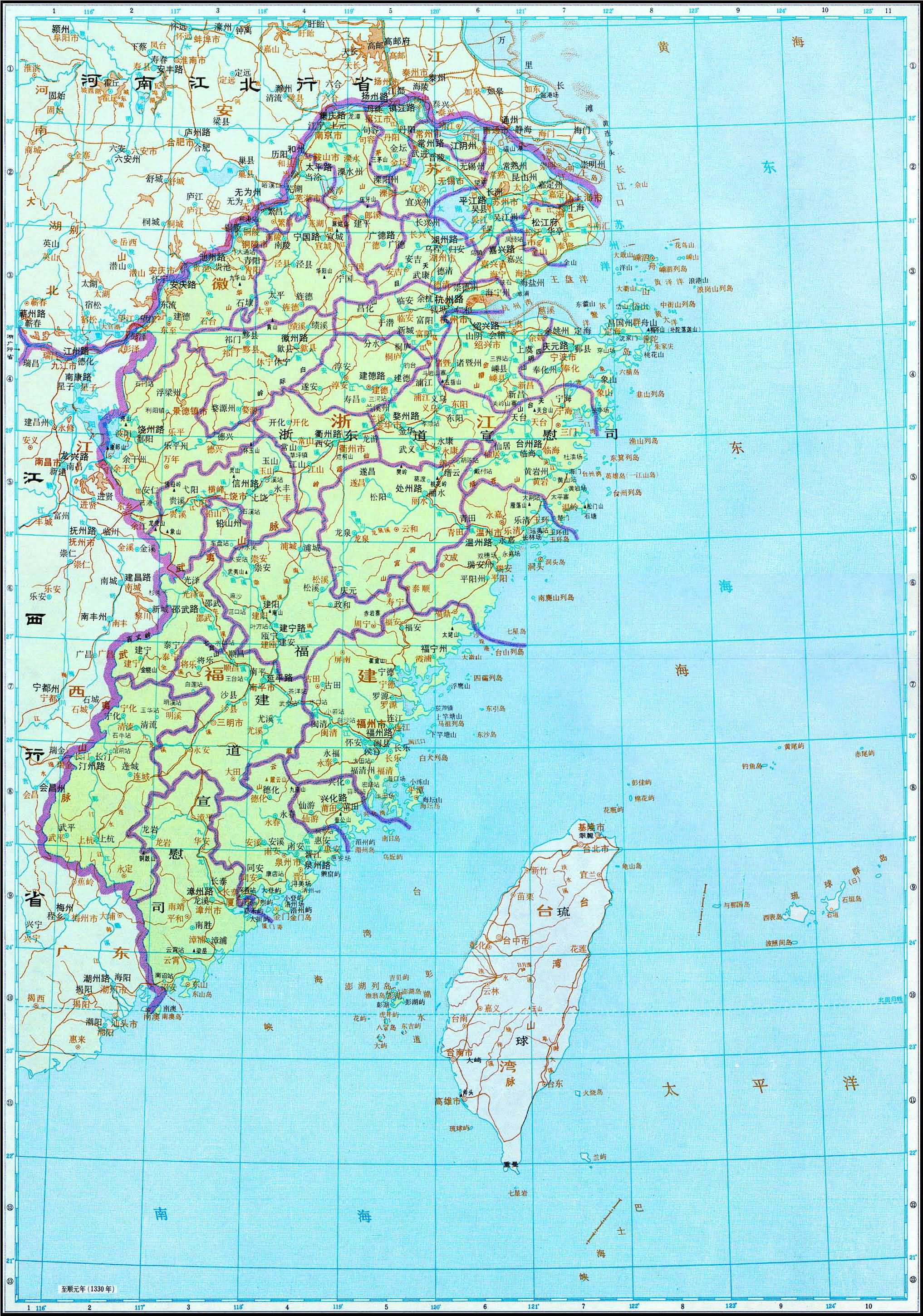
Yuan (1330 AD) : 江浙行省 Jiang Zhe Xing Sheng (Jiangzhe Province), included Fujian Circuit
Yuan.jpg
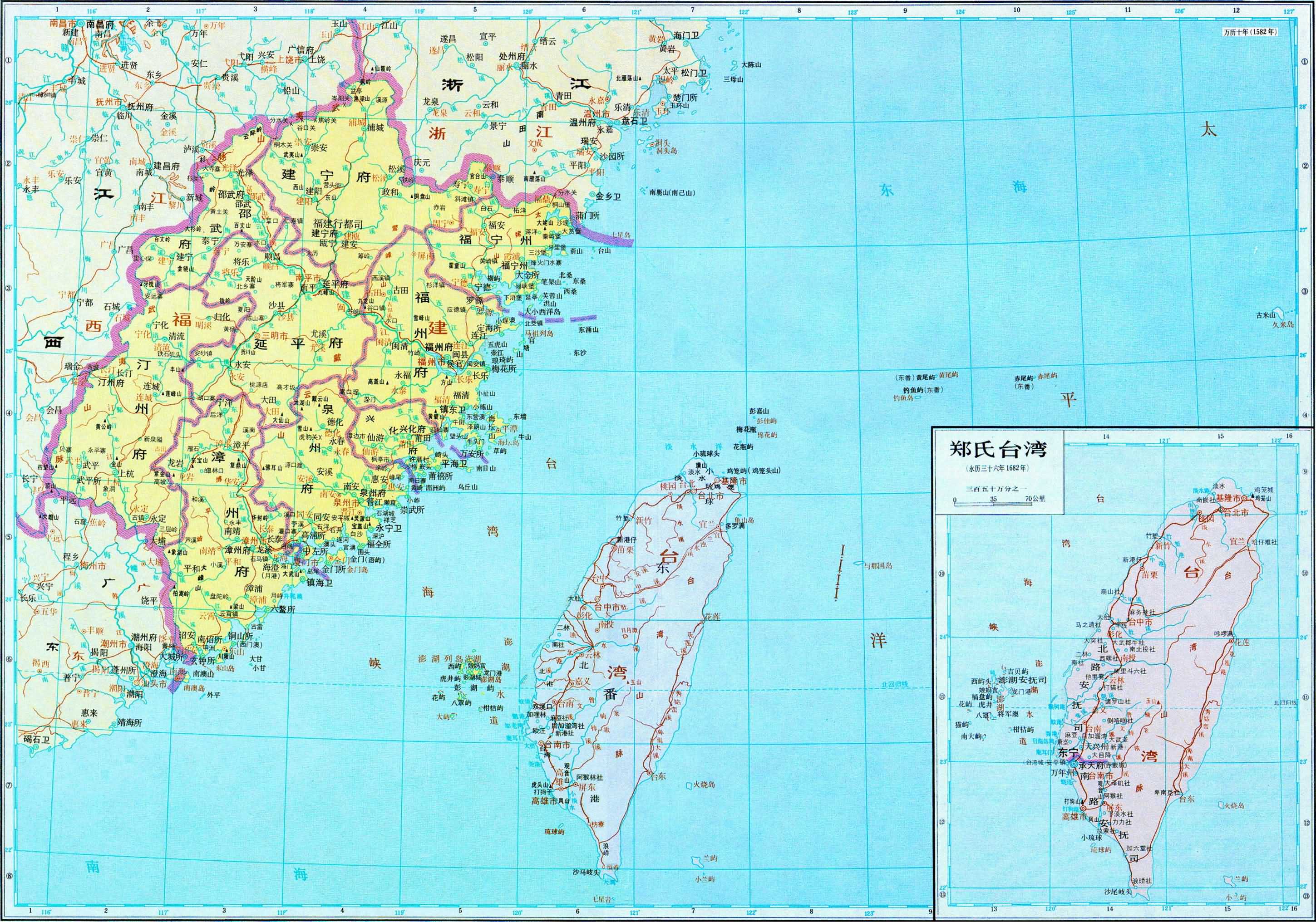
Ming (1582 AD) : 福建布政使司 (Fujian Province)
Ming.jpg
Qing (1820 AD) : 福建布政使司 (Fujian Province)
Qing.jpg
References:
[1] Tan, Qixiang (Ed.). (1996). The Historical Atlas of China: The Yuan & Ming Dynasty Period (vol. 7, pp. 27-28, 70-71). China Cartographic Publishing House. (Original work published 1982)
[2] Tan, Qixiang (Ed.). (1996). The Historical Atlas of China: The Qing Dynasty Period (vol. 8, pp. 42-43). China Cartographic Publishing House. (Original work published 1987)
[3] Wikipedia.
[4] Baidu Baike.
 
Last edited:
  • 16Like
  • 6
  • 2
Reactions:
there is a huge mistake in locations!


So the location should be named after the ancient county name (third-level administrative units). But in reality, most of names of locations are based on modern Chinese names of townships ([subdistrict] (街道) or [town] (镇), fourth-level administrative units) where the county seats are located. This is really ridiculous......XD

It's a choice from Tinto, consistent all over the world, to use village or city names for the locations. It would be very strange to treat China differently... (See post 416 on previous page)

If names are too modern (and Yuan or Ming alternatives exist), don't hesitate to provide the alternative, including where that corresponds to the (old?) county name.
But don't loose your time in just listing the county names. I would be very surprised if anyone at Tinto can make the difference between whether those are or are not the town/city/village names or the name of some larger region


Also, why are so many posts here partly bolded, coloured and larger typeface? That's a LOT of work which doesn't add anything, and severely reduces readability...
 
  • 9
  • 7
Reactions:
Linbot, which part of that advice do you disagree with? It was up like half a second...
At least based on other posts, evidently in China it went the other way around: villages and towns that were the capital of a county were named after the county. To the point where if the capital moved locations, they just renamed the new location to the county name.
 
Last edited:
  • 10Like
  • 2
  • 2
Reactions:
It's a choice from Tinto, consistent all over the world, to use village or city names for the locations. It would be very strange to treat China differently... (See post 416 on previous page)
Linbot, which part of that advice do you disagree with? It was up like half a second...


If names are too modern (and Yuan or Ming alternatives exist), don't hesitate to provide the alternative, including where that corresponds to the (old?) county name.
But don't loose your time in just listing the county names.
To be sure, you are correct that in Project Caesar settlement names are used in preference to geographical names, unless no settlement name is available. But in China, the name of the administrative division is the name of the town or city, and is used as such in official, colloquial, and historiographical contexts.
I would be very surprised if anyone at Tinto can make the difference between whether those are or are not the town/city/village names or the name of some larger region
There is no "difference", it's not meaningful. The names of the counties are way more recognisable and better attested.
 
  • 3Like
  • 2
  • 1
Reactions:
At least based on other posts, evidently in China it went the other way around: villages and towns that were the capital of a county were named after the country. To the point where if the capital moved locations, they just renamed the new location to the county name.
Exactly. Although it’s not strictly accurate, this serves as a good explanation for the Tinto team and others unfamiliar with Chinese place naming conventions. The actual name of the county seat is named after the county name, not the other way around.

Thank you very much for your clear and concise summary. I often end up writing long passages without realizing it, which makes it harder for others to understand what I’m trying to convey.;)
 
  • 9Like
  • 1
Reactions:
Yes, but all the names for them were exonyms, so we ended up going for the earliest one that wasn't offensive.

Speaking of offensive exonyms, I think you should rename Miao into Hmong.
 
  • 4Like
Reactions:
There's already a map of the Red Turban Rebellion posted in the Tinto Talks of situations:
Regarding the navigable rivers, I'm afraid it won't be possible.
Could you explain why this feature isn't possible? I've played EU4 mods where it’s implemented, so if modders can do it, why can't Tinto? Is it simply too late in the development process to add such a feature? I’ve asked about navigable rivers multiple times, and the response was always, 'We are looking into it.' Hearing 'it’s not possible' now is really disappointing. I understand that making every river navigable would be a huge task, so it would make sense if only the major rivers were made navigable
Then couldn't you make some of the rivers sea tiles? (The mouth of the Guadalquivir already works like that so Sevilla can be a port) You could simply add crossings between the provinces. I feel like that would be a better representation.
I would already love this idea, but Atromb’s idea could even be expanded by turning the entire river into a sea tile. This would allow navigation by ships, though smaller vessels would be more practical for river travel.

In a past post for the Netherlands region, I mentioned that cities in Holland , like Haarlem and Leiden, became key trading hubs for the North Sea due to their access through the Haarlemmermeer. Without this lake—and the sea connection it provided—these cities wouldn't have developed as they did. If their trade and transport options had been limited to overland routes, their growth would have been much slower.

Chinese cities, by contrast, do already have natural sea access through their rivers. However, river access provided more than just trade benefits. For example, Haarlem and Leiden were able to build warships and participate in naval engagements, allowing them to assert international influence. Similarly, Chinese cities could project their power through river routes like the Yellow River. Limiting naval power to cities with direct sea access oversimplifies the historical reality.
 
  • 5Like
  • 3
Reactions:
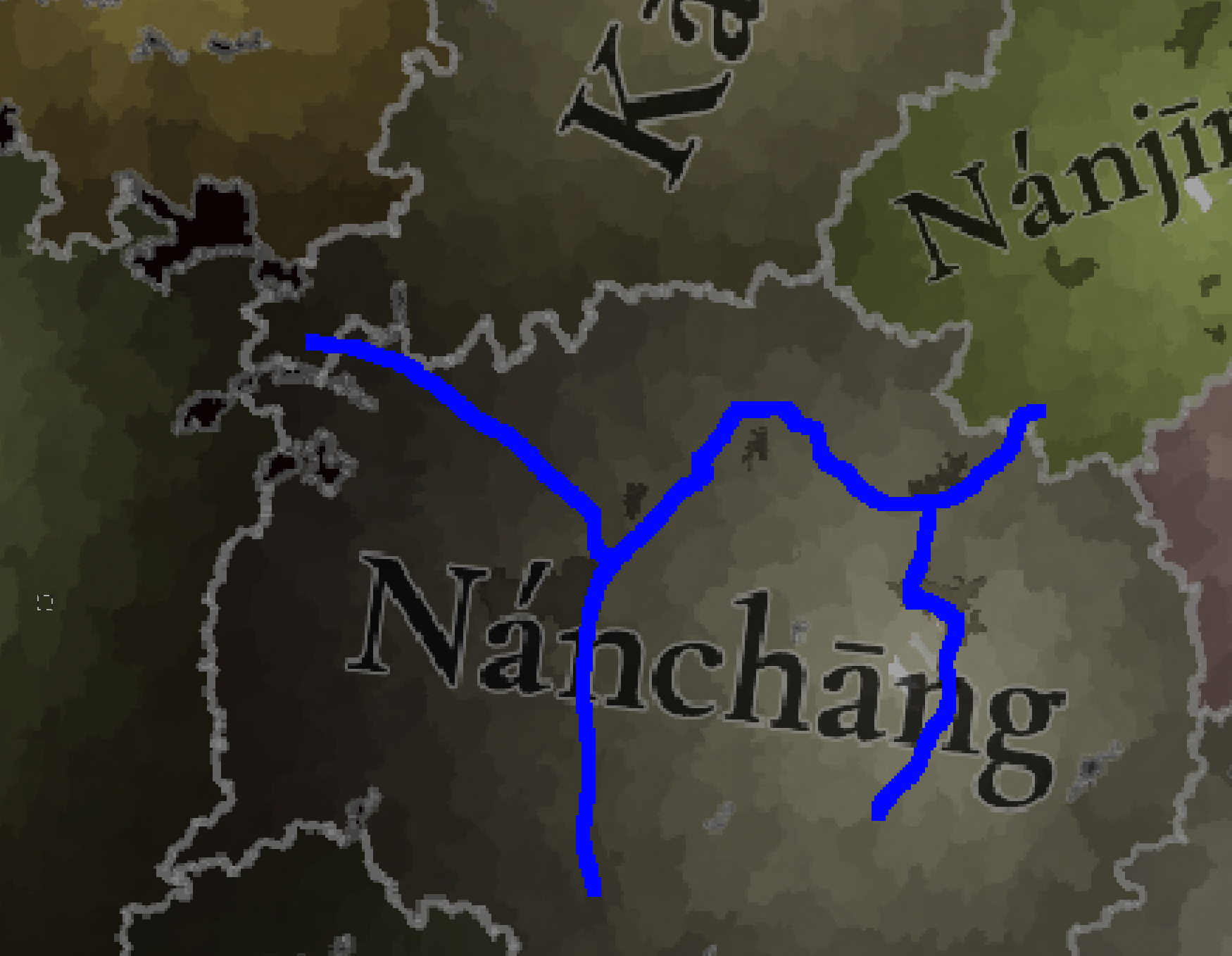
I have a significant issue with the markets that have been shown. I have marked the approximate course of the Yangtze river system in blue. The Yangtze is the trade bloodstream of central China. It is impossible to exaggerate its importance. But here we have the problem that because trade is totally unaffected by rivers, but is affected by terrain, most of the market access in the Middle Yangtze Valley is confined to Jiangxi.

It should be easier for trade to reach Changsha from Nanchang by going along the river than it should be for it to go through the Luoxiao Mountains.

This could be solved by moving the market capital to Wuchang, but that would be a superficial solution to the problem.

Screenshot 2024-10-19 at 16.46.36.png


Also, I think there should be way more farmland in the Yangtze river plain, especially the delta region. The game currently represents how this region was very densely populated, but that should be reflected by the development as well. It wasn't densely populated for no reason. This region should have very high population capacity.
 
  • 8Like
  • 2
Reactions:
I don't know about Vietnam and Korea, but in China, the blending of Confucianism, Buddhism, and Daoism in China was referred to in my history class was referred to as Neo-Confucianism. I know that you said that it shouldn't be named after Confucianism, but I don't see why it can be named after Buddhism but not Confucianism. The way I understand it (and I don't know that much about China so take what I say with a grain of salt), Confucianism was the main influencer of Chinese religion, hence neo-Confucianism instead of something else.
 
  • 1
Reactions:
At least based on other posts, evidently in China it went the other way around: villages and towns that were the capital of a county were named after the country. To the point where if the capital moved locations, they just renamed the new location to the county name.
You are absolutely right. This principle applies to settlements in all administrative regions (except provinces) of China.

It's a choice from Tinto, consistent all over the world, to use village or city names for the locations. It would be very strange to treat China differently... (See post 416 on previous page)

If names are too modern (and Yuan or Ming alternatives exist), don't hesitate to provide the alternative, including where that corresponds to the (old?) county name.
But don't loose your time in just listing the county names. I would be very surprised if anyone at Tinto can make the difference between whether those are or are not the town/city/village names or the name of some larger region
The three types of land divisions in the game should correspond to the three levels of administrative divisions in ancient China as follows:
Area --- [Province] (, It was called 承宣布政使司 in the Ming and Qing dynasties) / (*Province in PRC now)
Province --- [Fu] () / [Zhou] (直隶州) / (*Prefecture-level city in PRC now)
Location --- [County] () / [Zhou] (散州) / (*County in PRC now)

It can be clearly seen that locations are divided based on county-level administrative divisions. So the location should be named after the ancient county name (third-level administrative units). But in reality, most of names of locations are based on modern Chinese names of townships ([subdistrict] (街道) or [town] (镇), fourth-level administrative units) where the county seats are located. This is really ridiculous......XD

Usually, Chinese people directly use the county (or ancient fu / modern prefecture) name to as the name of the county town (or capital of ancient fu / modern prefecture-level city). We seldom use the subdistrict/town/village names to represent the county seat. And this situation was particularly prominent in ancient China.

There is another major issue with using township names (mostly modern place names) for the locations: it greatly reduces the recognition of locations.
First, most Chinese people are familiar with the names of counties but not townships. In recent days, many Chinese players have been complaining about this.
Secondly, the duplication of township names is quite common: many township names are actually newly created in modern times, with a higher proportion being those townships where the county seats are located. So, the phenomenon of township names being duplicated is naturally more common among them.
On the other hand, there is almost no phenomenon of duplicate names among different prefecture-level cities or counties. Besides, most of them are ancient place names that have been used for hundreds of years, which is really more representative.

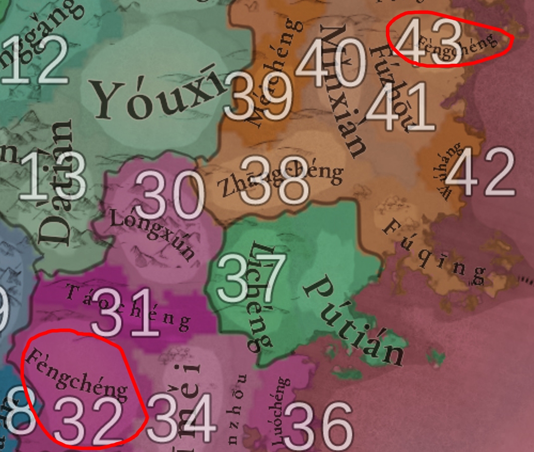
*Typical case: The towns where the county seats in Ānxī County (NO.32) and Liánjiāng County (NO.43) are located are both named "Fèngchéng" (凤城). The most interesting thing is that both "Fèngchéng Town" were born in 1982. And coincidentally, their predecessors were both called "Chéngguān" (the former was named this in 1958, and the latter was named this in 1961).
PS: There are a total of 9 "Fèngchéng Towns" in China now.
case.jpg


In addition, "Chéngguān" (城关, means city/town gate) is a general term for the county town in modern China. Here I quote an explanatory material (directly translated by Google):
It is said that among the more than 2500 counties in China, no matter how many townships or names there are, there is always a town called Chéngguān Town; No matter how many towns or situations there are, Chéngguān Town is always the first town in the county. This is not only because Chéngguān Town is the capital of a county, the political, economic, and cultural center of the entire county, but also because its economic strength is often the leader of all townships in the county.
Before the Qing Dynasty, county towns in China were directly under the jurisdiction of county governments and did not have a township system; The suburbs of the county are divided into townships, which are governed by village elders and gentry.
Starting from the Republic of China, some counties began to classify county towns as townships; Until the establishment of the People's Republic of China, a large number of county towns had established township systems, and many of them had no city names, generally referred to as "Chéngguān towns" by local people. Therefore, after the founding of the country, it was generally customary to establish numerous Chengguan towns, townships, districts, villages, and so on in various regions; The county seat of some counties has been relocated, and Chéngguān Town is no longer a county seat. However, after the relocation of the seat, the original historical title is generally retained.
Since the 1980s and 1990s, various regions have gradually realized this problem, and many "Chéngguān" in China, which are uniform, have begun to be renamed or divided into streets.

That's why the names of county level settlements are only suitable for using county names in China.
Due to political and cultural differences......
 
Last edited:
  • 10Like
  • 10
Reactions:
I too support the inclusion of Macau. I understand the decision not to include it due to being a small location, but if the same logic is not applied to other small locations, such as Gibraltar, then it is not a good excuse. In terms of importance, Macau was more important than Hong Kong during the game's entire timeframe, as the only european possession in China. Of course, it could've easily been the other way around, but the point stands.

I hope you reconsider the decision.
 
  • 12Like
  • 4
Reactions:
Can we use a older Chinese romanisation like that Of Chinese postal romanisation instead of modern romanisation?

Also it feels very weird to use Mandarin romanisation for all of Chinese provinces considering how southern China barely spoke mandarin during that period. Could they at least use romanisation of local languages for major sinitic languages like Hokkien and Cantonese?
I'm making a list of suggested names for areas, provinces, locations and cultures for southern china, currently working in progress (1.8k locations is a lot and would take some time). Hopes some of it would be considered and would be helpful.
I am only fluent in Cantonese and Mandarin so I dont know all the languages involved, if anyone sees any mistakes feel free to reply here to me or comment on the spreadsheet
Plan making the list for Kwangtung/Guangdong and Kwangsi/Guangxi areas first, then Fukien/Fujian and Chekiang/Zhejiang area. Then ill see if i still have motivation left to do the rest cos its a fuck ton.
A lot of the locations I cant figure out what they are suppose to be so if you see a blank slot on the spreadsheet and you know the place, please tell me thanks
 
  • 1
Reactions:
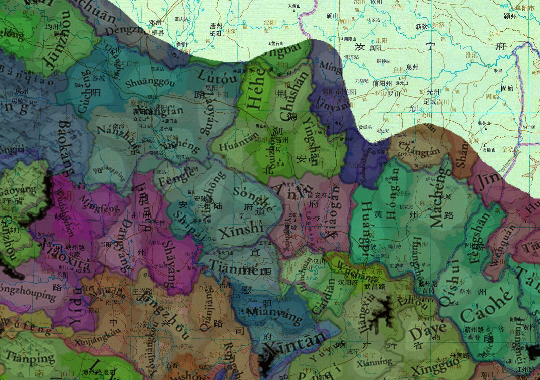
湖广省的地名已经过校对和更正。为了方便地图创建者,我不会包含不相关的历史信息,而只指定应该更改哪些地名。请假设我的来源主要来自《中国历史地图集》中的明朝地图集,就像我对四川和贵州的更正一样。

我已经用需要根据编号修改的地名注释了地图。在编号之后,我列出了建议的名称,然后是括号中的中文名称,最后是当前名称。

1. Luótián (羅田縣) <---- Fèngshān
2. 华安 (Huaán'an) <---- Hóngān
3. Huánggang (黃岡縣) <---- Huáng Zhōu
4. Qíshuǐ (蘄水縣) <---- Cáohé
5. Guǎngjì (廣濟縣) <---- Méichuān?
6. Xīngguózhōu (興國州) <---- Xīngguó
7. 通山 (Tōngshān) <---- Tōngyáng
8. 江夏縣 (Jiāngxià) <---- Wǔchāng
9. Zhǐfāng (紙坊) <---- Jiāngxià
10. Wǔchāng (武昌縣) <---- Èzhōu
11. 嘉魚縣 <---- Yúyuè
12. Chóngyáng (崇陽縣) <---- Tiānchéng
13. 通城区 (Tōngchéng (通城区) <---- Jùnshuǐ
14. 巴陵縣 (Bālíng) <---- 月燕
15. Bǎogàidòng (寶蓋洞) <---- Jūlíng
16. Lùkǒu (淥口) <---- Zhūzhōu
17. 永豐市 (Yǒngfēngshì) <---- Yǒngfēng
18. Lóudǐ (错别字)
19. Chējiāngshì (車江市) <---- Xīntáng
20. Yǒngxīng (错别字)
21. Guǎng'ān (廣安所) <---- Rǔchéng
22. Jǐntián (錦田所) <---- Tuójiāng
23. 道州 (Dàozhōu) <---- Dàojiāng
24. 零陵 (Línglíng) <---- Yǒngzhōu
25. Báimǎguān (白馬關) <---- Báimǎ
26. Chángjuàn (错别字)
27. Qiáotóu (橋頭鎮) <---- Wàngchéng
28. Wǔlíng (武陵縣) <---- 更改
29. Zhèngjiādiàn (鄭家店) <---- Zhèngjiāyì
30. Lǐzhōu (澧州) <---- Lǐ
31. 松滋縣 <---- Xīnjiāngkǒu
32. 枝江縣 <---- Mǎjiādiàn
33. 公安縣 (Gōng'ān) <---- Yóujiangkǒu
34. 江陵縣 <---- Jīngzhōu
35. Jiànlì (監利縣) <---- Róngchéng
36. 新堤 (Xīndī) <---- 辛坦
37. 景陵 (景陵縣) <---- Tiānmén
38. Hànyáng (漢陽縣) <---- Càidiàn
39. 建陽鎮 <---- Shāyáng
40. 京山 (Jīngshān) <---- Xīnshì
41. 钟祥縣 <---- Yǐngzhōng
42. Lùtóudiàn (鹿頭店) <---- Lùtóu
43. Xiāngyáng (襄陽縣) <---- Xiāngfán
44. Fánchéng (樊城) <---- Shuānggōu
45. 白河口 <---- Shàngyōng
46. Jiǔdàoliáng (九道梁) <---- Shénnóngjià
47. Xīngshān (興山) <---- Gāoyáng
48. 巴东 (Bādōng) <---- Xìnlíng
49. Chángyáng (長陽縣) <---- Lóngzhōupíng
50. 夷陵州 (Yílíngzhōu) <---- Xiǎoxītǎ
51. Wùlùhé (霧露河) <---- Wùlùhézhèn
52. Yuǎn'ān (遠安縣) <---- Míngfèng
53. 劍南司 (Jiànnán (劍南司) <---- Lìchuān
54. Dàtián (大田所) <---- Gāolèshān
55. 散毛宣撫司 <---- Xiānglíng
56. 施南宣撫司 (Shīnán) <---- Zhūshān
57. Báiyádòng (白崖洞司) <---- Mín'ān
58. 永宣慰司 (Yǒngshùn) <---- Língxī
59. 田家洞司 (Tiánjiādòng) <---- Gǔyáng
60. 保靖州宣慰司 (Bǎojìng <---- Qiānlíng
61. 五寨司 (Wǔzhài) <---- Tuójiāng
62. 漵浦縣 <---- Lúfēng
63. Zhènxī (鎮溪所) <---- Wǔxī
64. 辰溪 (辰溪) <---- Chényáng
65. 麻陽縣 <---- Jǐnhé
66. Yuánzhōu (沅州) <---- Lúyáng
67. 会同縣 <---- Línchéng
68. 綏寧縣 (Suīníng) <---- Chǎnpù
69. 新寧縣 (Xīnníng) <---- Jīnshí


View attachment 1204256
I need to correct you
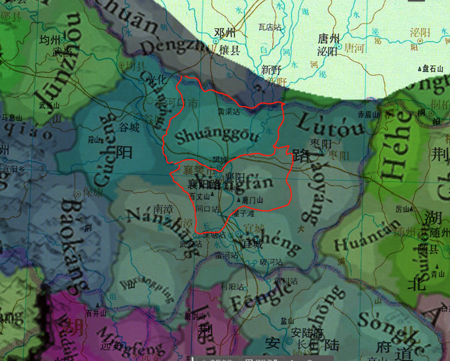
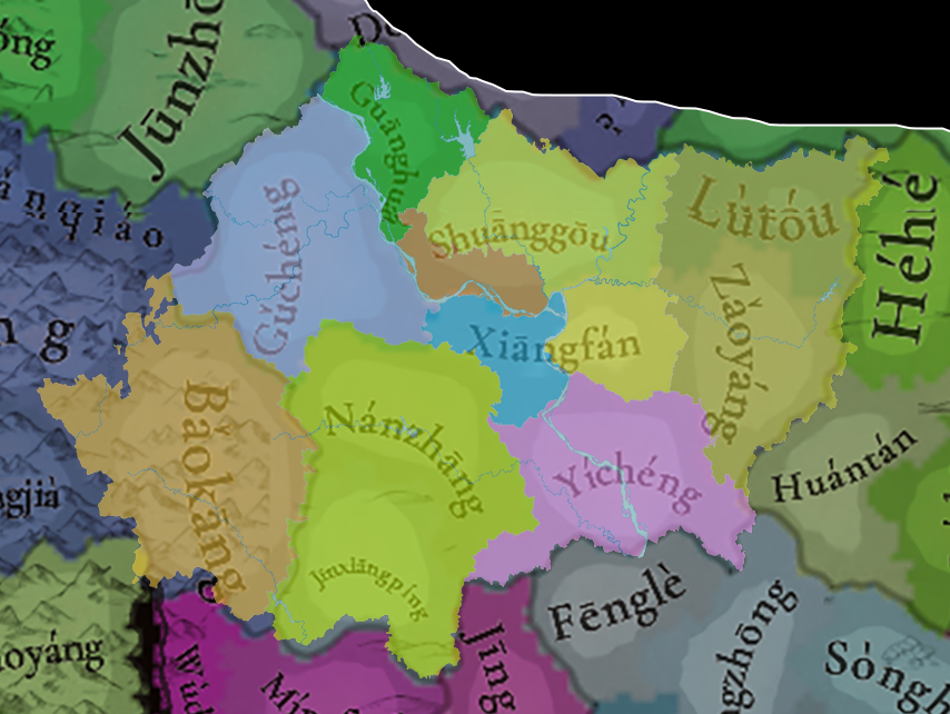
44, shuanggou is a real county, located in the northeast part of Xiangyang. According to the maps I have made, the “xiangfan” drawn by paradox is actually the merged parcel of Xiangyang and Fancheng, and shuanggou, in the size of the map, does not contain Fancheng!
1729390445878.png1729391560616.png
By comparing the original map with the modern administrative map, we can see that the official xiangfan actually contains parts of Xiangyang, Fancheng, and Xiangzhou (mainly their urban areas), while Shuanggou is the part of Xiangzhou district with the urban areas removed. Only Shuanggou is an early town in this area, and many other towns did not appear until modern times. This place appeared earlier, but records are scarce; in the Ming Dynasty, Shuanggou was Fuli, with an inspector's office; it was then renamed several times and eventually changed back to Shuanggou.

企业微信截图_17293930003157.png

Wait, I might be wrong, I just overlaid the Yuan dynasty map with the game map and realized that the Xiangfan plot is on the south side of the river, while Shuanggou is completely north of the river, in which case shuanggou is correctly called Fancheng, and Xiangfan should be called Xiangyang.
企业微信截图_17293930591275.png
 
Last edited:
I need to correct you
44, shuanggou is a real county, located in the northeast part of Xiangyang. According to the maps I have made, the “xiangfan” drawn by paradox is actually the merged parcel of Xiangyang and Fancheng, and shuanggou, in the size of the map, does not contain Fancheng!
View attachment 1204488View attachment 1204490
By comparing the original map with the modern administrative map, we can see that the official xiangfan actually contains parts of Xiangyang, Fancheng, and Xiangzhou (mainly their urban areas), while Shuanggou is the part of Xiangzhou district with the urban areas removed. Only Shuanggou is an early town in this area, and many other towns did not appear until modern times. This place appeared earlier, but records are scarce; in the Ming Dynasty, Shuanggou was Fuli, with an inspector's office; it was then renamed several times and eventually changed back to Shuanggou.

Well, I have thoroughly georeferenced it against modern administrative divisions using GIS. The current map's "Xiangfan" essentially consists of the modern "Xiangcheng" plus a part of "Xiangzhou" (at most, it includes a small part of southern "Fancheng" south of the river). It is not a "merger of Xiangcheng and Fancheng" as you mentioned. On the other hand, the current map's "Shuanggou" basically corresponds to the northern "Fancheng" and "Xiangzhou" north of the river. Please refer to the overlay images I have provided; I hope this clarifies the geographical relationships.

タイトルなし.png
2.png
3.png
 
  • 3Like
Reactions:
Well, I have thoroughly georeferenced it against modern administrative divisions using GIS. The current map's "Xiangfan" essentially consists of the modern "Xiangcheng" plus a part of "Xiangzhou" (at most, it includes a small part of southern "Fancheng" south of the river). It is not a "merger of Xiangcheng and Fancheng" as you mentioned. On the other hand, the current map's "Shuanggou" basically corresponds to the northern "Fancheng" and "Xiangzhou" north of the river. Please refer to the overlay images I have provided; I hope this clarifies the geographical relationships.

View attachment 1204497View attachment 1204498View attachment 1204499
企业微信截图_17293931723419.png

I found out something else, during the Yuan Dynasty “Zhongxiang”鍾祥 was called Changshou長壽, and it was the capital of Anlu Prefecture安陸府, but the real Anlu安陸 was the capital of De'an Prefecture德安府. And Wuchang武昌 should be called Jiangxia江夏, Ezhou鄂州 is a newly founded city, which was called Wuchang武昌 in Yuan Dynasty.
Is that what you found out?
 
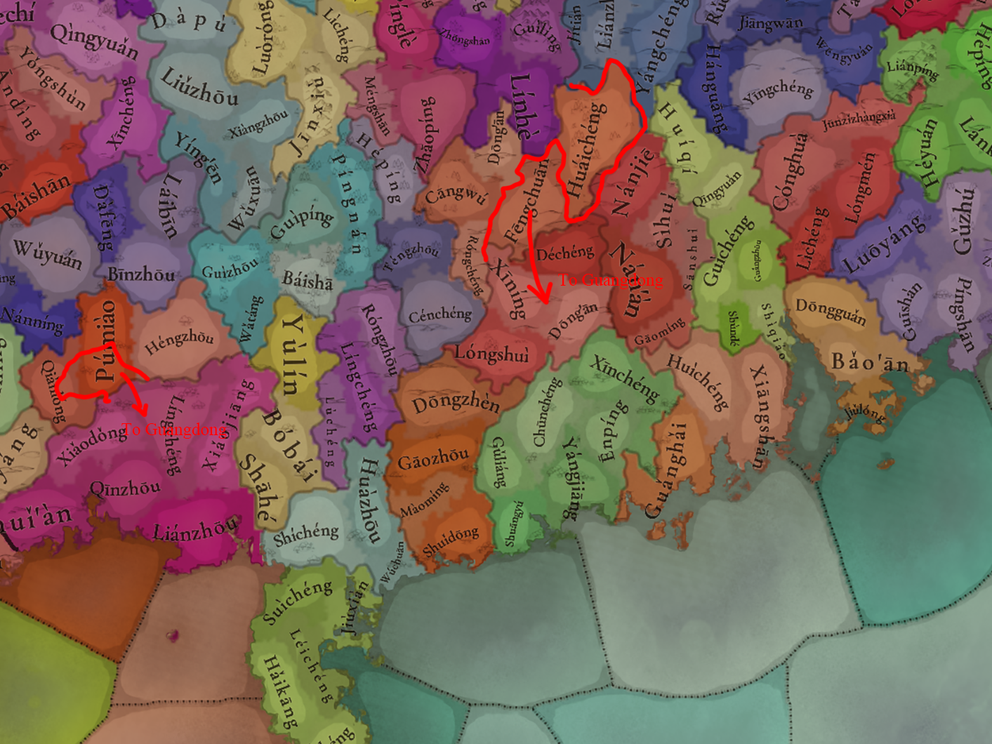
There are a few adjustments needed for the boundary between Guangdong and Guangxi. Firstly, part of Púmiào and Qiǎnlóng in the west should be allocated to Língchéng. Additionally, Fēngchuān in the east should belong to Guangdong.

Adjust.png

19.jpg
 
  • 4Like
Reactions:
There's already a map of the Red Turban Rebellion posted in the Tinto Talks of situations:
Regarding the navigable rivers, I'm afraid it won't be possible.
Really such a shame to not have rivers represented on the map. From a naval perspective, navigable parts of the Yangtze, Danube, Saint Lawrence etc. would have been great. But even just aesthetically, it feels off not having these great waterways that have defined so many civilizations visible on the map.

Just speculating: If the issue is with the sea-tile system and/or the AI, why not show major rivers at least graphically? They could be coded similar to wasteland corridors. That way, the AI will know how to cross and being only one tile (or maybe two), per river, the performance cost would be negligible.
 
  • 10Like
  • 4
Reactions:
Those islands indeed belong to Lloa.
Pardon, Penghu actually didn't belong to Lloa in the period of Yuan
Since Yuan had set administration on islands of Penghu, on Magong(馬公) since 1281, calling it Inspection Division (巡檢司)

"Penghu County is the earliest governmental division of Taiwan. The history of its development can be traced to the Yuan Dynasty establishing the inspection division." From Penghu website (The Chronicles of the Hall-Penghu Reclamation Hall)

The Inspection Department even lasted when Ming took over, becoming an important role in the Later Ming and Cheng's regime in Taiwan later on

Therefore Penghu should be a separated location that controlled by Yuan, not an area included by Taiwan, thank you.
 
  • 7
  • 4Like
Reactions:
View attachment 1204517
I found out something else, during the Yuan Dynasty “Zhongxiang”鍾祥 was called Changshou長壽, and it was the capital of Anlu Prefecture安陸府, but the real Anlu安陸 was the capital of De'an Prefecture德安府. And Wuchang武昌 should be called Jiangxia江夏, Ezhou鄂州 is a newly founded city, which was called Wuchang武昌 in Yuan Dynasty.
Is that what you found out?
According to a reference guideline previously mentioned by the Tinto team (apologies, I forgot who and where this was mentioned), the place names should generally be selected based on the longer duration of use, rather than the names from the year 1337 (i.e., the start time of the game). Therefore, I have primarily referred to Ming Dynasty place names and have not considered those from the Yuan Dynasty.