• We have updated our Community Code of Conduct. Please read through the new rules for the forum that are an integral part of Paradox Interactive’s User Agreement.

Tinto Maps #23 - 18th of October 2024 - China

Hello, and welcome to another week of Tinto’s fun Maps. This week it will be a huge one, as we will take a look at the entirety of China. It is a really big area, but it didn’t make sense to split it into multiple parts to present it separately, so we are showing it all at once. So, without further ado, let’s get started.

Countries
Countries.png
Colored impassables.png

Obviously the territory is dominated by Yuán, with Dali as its vassal. They appear big, strong, and scary, but they will have their own fair share of problems for sure. I will not go into detail into the countries that can be seen further south, as we will talk about Southeast Asia in a future Tinto Maps.

Societies of Pops
SoP.png

Quite a variety of peoples in Southwest China, as you will see later in the culture maps.

Dynasties
Dynasties.png

Here we finally have managed to catch the full name of the Borjigin dynasty in all its glory.

Locations
Locations.png

Locations zoom 1.png

Locations zoom 2.png

Locations zoom 3.png

Locations zoom 4.png

Locations zoom 5.png

Locations zoom 6.png

Locations zoom 7.png

Locations zoom 8.png

Locations zoom 9.png
Before you ask, there are around 1800 locations in China proper, not counting impassables and barring possible counting errors.

Provinces
Provinces.png

Provinces zoom 1.png
Provinces zoom 2.png
Provinces zoom 3.png
Provinces zoom 4.png
Provinces zoom 5.png

Areas
Areas.png


Terrain
Topography.png
Climate.png
Vegetation.png

You will notice here that there are few locations assigned as "farmlands", that's because when we did this part of the map there was yet not a clear criteria on how we would be defining the farmlands and their placement here hasn't been reviewed yet.

Development
Development.png

As mentioned before, the harsh changes of development at the end of China proper is probably too strong right now and it’s something that will have to be reviewed, especially at the Liáodōng area.

Natural Harbors
Natural Harbors.png


Cultures
Cultures.png

Cultures zoom 1.png

Cultures graph.png

There is a lot of cultural variation in China, not only among the sinitic peoples (which have been divided according to their linguistical and dialectal differences) but also having many other types of non-sinitic peoples. The resulting pie chart for the cultures of the country is a wonder to see indeed. And even if Yuán itself is Mongolian, there are actually very few Mongolian people in the country, as only the ruling class would belong to it. That is one other source of further trouble for Yuán.

Religions
Religions.png

Religions zoom.png
Considering religion, there is also a lot of variation in the South West, and one thing you will notice is the clear lack of “Animism”. We have finally eliminated Animism as a religion from the game and have divided it into many multiple ones. Besides this, and some Muslim presence in some areas, there are other small pockets of religions that do not get to appear in the map, like Manichaeism, Nestorianism, Judaism and Zoroastrianism. And the elephant in the room is the Mahayana, that we have already mentioned that we have plans on dividing it, but more on it at the end.

Raw Materials
Raw materials.png

Raw materials zoom 1.png

Raw materials zoom 2.png
Raw materials zoom 3.png
Raw materials zoom 4.png
A very resource rich region, which makes it understandable that China was able to basically be self-sufficient in terms of resources for long periods in history, and with many sources of highly appreciated resources like silk, tea, and even soybeans. Another interesting thing is the division on the preference of grain cultivation, with rice being more prominent in the south while the north tends to favor wheat and sturdy grains (millet, basically).

Markets
Markets.png


Population
Population.png

Population zoom 1.png
Population zoom 2.png
Population zoom 3.png
Population zoom 4.png
Population zoom 5.png
Population zoom 6.png
Population zoom 7.png
Population zoom 8.png
Yes, there’s a lot of population in China, and with that many people and that many resources it obviously has a lot of potential. We have been following population census of 1351 and 1393, which allows us to have the most accurate values we can have.

Now, before closing off, let me turn back once again to the subject of religion, as it has already been pointed out that having a single Mahayana religion covering both China and Tibet (and parts of India) may not be the best both for accuracy and gameplay reasons, and we basically agree with it so we are planning on reworking a bit but it hasn’t been done in time for this Tinto Maps. However, as we are aware that you are not able to provide proper feedback unless we present you something, let me now share with you what are our plans with it. Please keep in mind that I will NOT go into details about their mechanics, and only talk about their distribution.

First of all, Tibetan Buddhism will be split and turned into its own religion. Although it “technically” is part of the Mahayana branch, it is true that its practices have distinguished it from Chinese Buddhism enough to represent it as its own religion, starting from the fact that they do not follow the same canon. The Mahayana that was present in India was already an outlier from start, so it will be made into its own religion.

That leaves out that the current “Mahayana” remaining in game will be Chinese Buddhism, that is, those following the Chinese Buddhist canon, and it will be present in China, Korea, and Vietnam. The question remains on what to call the religion, and several things have to be considered for that:

  1. The religion will already include blended into it Confucianism and Daoism besides Buddhism, so all three religions are included. That means it can’t be named either Confucianism or Daoism, as they have been bundled in. Buddhism was taken as the base name because, from the three, it was considered as the one mostly oriented towards the “religious” (Confucianism being more focused on administration and Daoism on rituals), and the most similar to what an organized religion would be outside of China.
    1. As a subpoint on that, and I can’t go into details for it yet, but there will also be options inside it to favor Buddhism over Confucianism or the opposite, so that is already covered too.
  2. As mentioned, it will be present not only in China but also in Korea and Vietnam (and any other country that may convert too, like for example Japan), so naming it something that’s too intrinsic to Chinese identity would not be ideal. That would mean that a term like Sānjiào, although good, would feel a bit out of place when playing for example as Korea (we know that the concept spread there too, but it was more prominent inside China and regardless having the name be directly in Chinese would be the main issue when playing outside China)

So, for now, the current name we are considering for the religion is directly “Chinese Buddhism”, or even leaving it as “Mahayana”, understanding that the main current of Mahayana is the version following the Chinese canon anyway. But feel free to suggest any alternative naming if you feel that there may be a better option we haven’t thought of, as long as it takes into consideration the previous points. And of course, let us know your feedback on the proposed representation and distribution too.

And that’s it for today, after a bit longer closing than usual. Next week we’ll be back a bit further east, taking a look at Korea and Japan. Hope to see you there!
 
  • 202Like
  • 66Love
  • 9
  • 6
  • 4
Reactions:
I have to admit, I'm not sure if I'm a huge fan of showing all of the principalities as actual landed countries. I would argue these arrangements were more about recieving income than actually managing governance, although this might be a false perception, I'm more familiar with the Ming system (if this was a map of Ming, I absolutely would not be happy with this). Feel free to disagree!

View attachment 1222316

As for the Northeast, I don't think the Hoifa, Hada, or Ula should exist. Probably not the Yehe either. Firstly I'm pretty sure that region was inhabited by the Sibe before the Ming dynasty. It's hard to tell when the Hoifa actually migrated to their late 16th century-position, but given that they aren't mentioned as far as I am aware before the late 16th century, this probably happened during the Ming dynasty. The Haixi confederation did not form until the Jiajing era. There are Jurchens referred to as Haixi during the Yuan dynasty, but this is actually an alternative name for the Shuidada 水达达 Jurchens (the tribe that is divided into the Taowen, Huligai, Odoli, Tuowolian, and Beikujiang).

The Hada are also especially weird here because they're sitting right on top of a major Chinese city, Tieling.

I'm pretty sure the Handuoli are just another name for the Odoli.

I would draw the region like this (ignore Korea).

View attachment 1222354

I don't really know what goes in the question mark area you've indicated between Korea and China near Changbai Mountain. As best I can tell, this was probably inhabited by Jurchens, but I would guess it was very sparsely populated, since there are no administrative units there or tribes significant enough to be mentioned in the sources.

Tusi Proposal:

I have expanded on the work of a friend of mine who created a map of the Yuan dynasty during the Red Turban Rebellion. Sources are History of Ming, History of Yuan, the book 中国土司制度, wikipedia, and baidu baike.

Named in red are the major Tusi polities
Named in orange are subordinate Tusi. These were also sometimes relevant, for example during the Bozhou Rebellion, most of the subordinate tusi of Bozhou did not join the rebellion and were conquered by the Bozhou polity during the war. Also, the Sizhou polity was abolished during the early Ming dynasty, but its subordinate tusi (except for Liping which was also abolished) continued to exist until the Qing period. Same thing with Beizheng and Yongning
Marked in light grey are those areas which seem not to have been under the Yuan dynasty's authority at all. In the modern region of the Liangshan Yi Prefecture in Sichuan, I would suggest adding a Black Yi SOP. The Guizhou areas were all referred to by the Chinese as "Wild Miao" although they are a mixture of in-game cultures, they could be multiple SOPs. Meanwhile, in Hainan there should be a Hlai SOP.

View attachment 1222368

Notes:
Probably most of the major tusi (other than maybe the Dai tusi and Lijiang) and possibly the minor ones as well, should have Chinese as their court language. Bozhou, Shuidong, and Sizhou were especially sinicised.
Lai'an's name was changed to Sicheng in the early Ming dynasty.
In the early Ming dynasty, Menggu, Shunning, Qingyuan, Dali, Mong Mao, Beizheng, Rende, Luoxiong, Guangxi, Mile, Shizong, Guangnan, Ningzhou, Shiping, Liping, Sizhou, Yunlian, Rong, Gong, Puding, Pu'an, Zhanyi, and Luoluosi were abolished during the early Ming dynasty.
Sizhou had a civil war during the early Ming dynasty where the Sinan polity (also including Zhenyuan) broke away to become separate under a pretender rebel, Ming intervened in the war and annexed them.
After the defeat of Mong Mao, more Tusi were established on its former territory, including Mangshi, Mong La, Nandian, and Mong Wan. I also think Zhenkang, Mong Ting, and Mong Myen came into existence as well.
A Qujing Tusi was briefly established during the early Ming dynasty but seems to have ceased to exist after a few generations?
Luozuo and Anning were absorbed into Fuzhou during the early Ming dynasty
Mahu was annexed into Wumeng I think during the early Ming dynasty, and parts of it were organised into four smaller tusi
Kaili, Anlong, Shanglin, Yongshun, Xincheng, Anding, and Duyang were established during the Ming dynasty. I have chosen to show them here since I assume they evolved from earlier power structures that were not officially recognised by China, and I'm not sure exactly what would be in Kaili's place in 1337.
I think Gyalthang was vassalised or possibly annexed by Lijiang during the Ming dynasty? During the late Ming dynasty Lijiang expanded north into Kham


Primary cultures (this is very subject to error since information is difficult to find and is disputed, so I would appreciate any corrections or help):

View attachment 1222373

Reddish-brown - Nakhi
Yellow - Dai
Teal - Hani
Sky-Blue - Bai
Lavender - Zhuang
Blue - Miao
Deep Blue - Kam
Brown - Sui
Olive - Tujia
Green - Yi
Tuquoise - Bo


I mostly agree with not including all of the principalities. As usual to my maps, I've included every entity I could find as a baseline, but it doesn't mean all of them should be included. That's why I suggested having them abstracted into the wuhusi-system to still represent their power.

I would keep the principalities that had later impact, such as Liang who would go to defend Yunnan, and Bin who would go on to form Kara Del. Some of the other principalities were involved in the Red Turban Rebellion with side switching action between the loyalist factions, but not much further than that due to being wiped out.


  • 2
Reactions:
qiangic.png

Screenshot_20241107_194540_Gallery.jpg

Cultures of the Tibetan-Yi Corridor

The Tibetan-Yi corridor is a linguistically diverse region, characterized by intense interaction between various polities and peoples.

My work is largely based on "Mapping the Minority Languages of the Eastern Tibetosphere", taking into the consideration of the political lanscape of the 14th century.

1. Daohua (倒話) should not exist, as it is a Chinese-Tibetan syncretic language that appeared after the influx of Han Chinese
2. There should not be a significant Yi population in areas westwards of Xichang (西昌). The Yi migration to Jiulong, Muli, Mianning, Hanyuan, Shimian, Ninglang, Yongsheng occurred in the Qing Dynasty.
3. Naxi should not exist in Muli and Markham, as most of these settlements were established during the 16th century by the Principality of Lijiang.
4. There should not be much Han Chinese in the modern counties of Tianquan, Hanyuan, Xinmian, Baoxing, Luding, Kangding. These areas were ruled by Tusi chiefdoms.

References:
https://www.researchgate.net/public...inority_Languages_of_the_Eastern_Tibetosphere.

1. Pumi
- Status: society of pop
- Religion: Hangui

Historically, there is a significant population of Pumi in the Muli county, which founded the Principality of Muli in the 17th century.

2a. Naic - Nakhi

Yanyuan should have a predominant Mosuo (Nakhi) population. Until the 20th century, the peripheral areas of Yanyuan were ruled by Mosuo chieftains.

Reference: The Ancient Na-khi Kingdom of Southwest China
yanyuan.jpg

zuosuo.jpg

2b. Naic - Namuyi
-Status: non-tag culture
- Religion: Phatsa (p h a ⁵⁴ tsə ⁵⁴-a)

Reference:

3. Ersuic - Ersu, Doxu, Lizu
- Status: society of pop
- Religion: Shaaba

The Ersu people have a writing system called Shaaba hieroglyph, and had founded small principalities under Tibetan influence. Sajiabu (撒加布), mentioned in the "History of Yuan", is identified as a chieftain of the Doxu people.

Reference:

4a. Qiangic - Minyag

- Status: settled country
- Religion: Bon, Tibetan Buddhism

The Principality of Chakla (明正土司) ruled over both Tibetans speaking the “Minyag Rabgang dialect” of Tibetan, and Qiangic people speaking the Minyag language.

I suggest to rename Chakla as Minyag, since Chakla is a dynasty name first mentioned in the 17th century, while Minyag is an older geo-political concept.

Reference:

4b. Qiangic - Gochang

- Status: settled country
- Religion: Bon, Tibetan Buddhism

The Guiqiong people, also known as "Yutong" (魚通), had formed several principalities by the 15th century. The Principality of Yutong (Guthang) is among the Eighteen Principalities of Gyalrong.

Reference:

4c. Qiangic - Gyalrong (Gyalrong, Geshitsa, R'tau, Nyagrong Minyag)
- Status: settled country
- Religion: Bon, Tibetan Buddhism

Covered in a previous post:

R'tau and Nyagrong Minyag should be non-tag cultures.

4d. Qiangic - nDrapa-Choyo
- Status: non-tag cultures
- Religion: ?

Simple clan societies.

Reference:
 

Attachments

  • yanyuan.jpg
    yanyuan.jpg
    812,9 KB · Views: 0
  • wusuo.jpg
    wusuo.jpg
    708,6 KB · Views: 0
Last edited:
  • 6Like
Reactions:


In the following map of Yuan, I've compiled various map feedback changes from across the Mongolia, China, Steppes and Chagatai threads. Let me know if I should add or change something, etc.

Items in WIP, any help is welcome:
  • Countries without a name = ?
  • The Yuan gap in middle of the Jurchen lands (did Yuan hold it? or someone else?)
  • SoPs of Formosa


View attachment 1222151
Locations:
View attachment 1222149
I have to admit, I'm not sure if I'm a huge fan of showing all of the principalities as actual landed countries. I would argue these arrangements were more about recieving income than actually managing governance, although this might be a false perception, I'm more familiar with the Ming system (if this was a map of Ming, I absolutely would not be happy with this). Feel free to disagree!

View attachment 1222316

As for the Northeast, I don't think the Hoifa, Hada, or Ula should exist. Probably not the Yehe either. Firstly I'm pretty sure that region was inhabited by the Sibe before the Ming dynasty. It's hard to tell when the Hoifa actually migrated to their late 16th century-position, but given that they aren't mentioned as far as I am aware before the late 16th century, this probably happened during the Ming dynasty. The Haixi confederation did not form until the Jiajing era. There are Jurchens referred to as Haixi during the Yuan dynasty, but this is actually an alternative name for the Shuidada 水达达 Jurchens (the tribe that is divided into the Taowen, Huligai, Odoli, Tuowolian, and Beikujiang).

The Hada are also especially weird here because they're sitting right on top of a major Chinese city, Tieling.

I'm pretty sure the Handuoli are just another name for the Odoli.

I would draw the region like this (ignore Korea).

View attachment 1222354

I don't really know what goes in the question mark area you've indicated between Korea and China near Changbai Mountain. As best I can tell, this was probably inhabited by Jurchens, but I would guess it was very sparsely populated, since there are no administrative units there or tribes significant enough to be mentioned in the sources.

Tusi Proposal:

I have expanded on the work of a friend of mine who created a map of the Yuan dynasty during the Red Turban Rebellion. Sources are History of Ming, History of Yuan, the book 中国土司制度, wikipedia, and baidu baike.

Named in red are the major Tusi polities
Named in orange are subordinate Tusi. These were also sometimes relevant, for example during the Bozhou Rebellion, most of the subordinate tusi of Bozhou did not join the rebellion and were conquered by the Bozhou polity during the war. Also, the Sizhou polity was abolished during the early Ming dynasty, but its subordinate tusi (except for Liping which was also abolished) continued to exist until the Qing period. Same thing with Beizheng and Yongning
Marked in light grey are those areas which seem not to have been under the Yuan dynasty's authority at all. In the modern region of the Liangshan Yi Prefecture in Sichuan, I would suggest adding a Black Yi SOP. The Guizhou areas were all referred to by the Chinese as "Wild Miao" although they are a mixture of in-game cultures, they could be multiple SOPs. Meanwhile, in Hainan there should be a Hlai SOP.

View attachment 1222398

Notes:
Probably most of the major tusi (other than maybe the Dai tusi and Lijiang) and possibly the minor ones as well, should have Chinese as their court language. Bozhou, Shuidong, and Sizhou were especially sinicised.
Lai'an's name was changed to Sicheng in the early Ming dynasty.
In the early Ming dynasty, Menggu, Shunning, Qingyuan, Dali, Mong Mao, Beizheng, Rende, Luoxiong, Guangxi, Mile, Shizong, Guangnan, Ningzhou, Shiping, Liping, Sizhou, Yunlian, Rong, Gong, Nanping, Puding, Pu'an, Zhanyi, and Luoluosi were abolished during the early Ming dynasty.
Sizhou had a civil war during the early Ming dynasty where the Sinan polity (also including Zhenyuan) broke away to become separate under a pretender rebel, Ming intervened in the war and annexed them.
After the defeat of Mong Mao, more Tusi were established on its former territory, including Mangshi, Mong La, Nandian, and Mong Wan. I also think Zhenkang, Mong Ting, and Mong Myen came into existence as well.
A Qujing Tusi was briefly established during the early Ming dynasty but seems to have ceased to exist after a few generations?
Luozuo and Anning were absorbed into Fuzhou during the early Ming dynasty
Mahu was annexed into Wumeng I think during the early Ming dynasty, and parts of it were organised into four smaller tusi
Kaili, Anlong, Shanglin, Yongshun, Xincheng, Anding, and Duyang were established during the Ming dynasty. I have chosen to show them here since I assume they evolved from earlier power structures that were not officially recognised by China, and I'm not sure exactly what would be in Kaili's place in 1337.
I think Gyalthang was vassalised or possibly annexed by Lijiang during the Ming dynasty? During the late Ming dynasty Lijiang expanded north into Kham
Wuzhai came under the control of Baojing


Primary cultures (this is very subject to error since information is difficult to find and is disputed, so I would appreciate any corrections or help):

View attachment 1222396

Reddish-brown - Nakhi
Yellow - Dai
Teal - Hani
Sky-Blue - Bai
Lavender - Zhuang
Blue - Miao
Deep Blue - Kam
Brown - Sui
Olive - Tujia
Green - Yi
Tuquoise - Bo

About Möng Mao, my last post on them (which I'm assuming is where Linbot got the borders from?) was kinda speculation based on one source, so I did some more research on the setup, comparing between Chinese and Tai sources about Hsö Hkan Hpa (Si Kefa). I think they would more accurately look like this:
(Outdated map)
Untitled18_20241127122331~3.png


This is assuming 1335 is the year Hsö Hkan Hpa became leader. It could have been another date, but 1335 is apparently the most reliable and the Chinese Wikipedia entry on Si Kefa uses this date. The Tai chronicles date his ascension to hopelessly wrong years like 1152 and 1225, but the facts (like the war with Yuan) generally line up once you adjust the starting point to 1335, which is what Chinese scholars do.

On the Burmese side, Möng Mao own Namhkam and Muse, these are in the Mao valley and the Mao rulers shifted capitals between these locations. Hsenwi was also subjugated 2 years into Hsö Hkan Hpa's rule (1337) and Möng Mit was subjugated the next year (1338).

Screenshot_20241127-182827.png
Hsenwi chronicle

On the Yunnan side, they had first subjugated the land up to Yongchang (Baoshan), and didn't go southwards to Zhenkang, Küngma, and Möng Möng until 1342.

Küngma and Möng Möng are mentioned in the Tai chronicles, Zhenkang is the Zhenkang Route established by the Yuan dynasty (all of the 'Routes' in Yunnan seem to have been ruled by local chieftains by this point, Möng Mao for example was originally Luchuan Route and had a native ruler since its establishment.)

Screenshot_20241127-103020.png
Story of Mong Mao (Mithila = Yunnan in this)

For the other Tai states, I remember reading Dahou hadn't been established until the Ming dynasty but I can't find that now (maybe I'm wrong), and I'm not sure what Menggu refers to except for Jingdong which was established in 1331 in the same area.

Tai names:
Shidian = Möng Mo
Shunning = Möng Hten
Dahou = ?
Jingdong = Keng Tung or Möng Tung (ᥛᥫᥒᥰ ᥖᥧᥒᥴ)
Weiyuan = Möng Wö (ᥛᥫᥒᥰ ᥝᥨᥝᥰ). It's also called Möng Ka (ᥛᥫᥒᥰ ᥐᥣᥲ) because it was originally 2 towns, but only Möng Wö is used nowadays.
 
Last edited:
  • 4Like
Reactions:
About Möng Mao, my last post on them (which I'm assuming is where Linbot got the borders from?) was kinda speculation based on one source, so I did some more research on the setup, comparing between Chinese and Tai sources about Hsö Hkan Hpa (Si Kefa). I think they would more accurately look like this:
View attachment 1222623
View attachment 1222603

This is assuming 1335 is the year Hsö Hkan Hpa became leader. It could have been another date, but 1335 is apparently the most reliable and the Chinese Wikipedia entry on Si Kefa uses this date. The Tai chronicles date his ascension to hopelessly wrong years like 1152 and 1225, but the facts (like the war with Yuan) generally line up once you adjust the starting point to 1335, which is what Chinese scholars do.

On the Burmese side, Möng Mao own Namhkam and Muse, these are in the Mao valley and the Mao rulers shifted capitals between these locations. Hsenwi was also subjugated 2 years into Hsö Hkan Hpa's rule (1337) and Möng Mit was subjugated the next year (1338).

View attachment 1222643
Hsenwi chronicle

On the Yunnan side, they had first subjugated the land up to Yongchang (Baoshan), and didn't go southwards to Zhenkang, Küngma, and Möng Möng until 1342.

Küngma and Möng Möng are mentioned in the Tai chronicles, Zhenkang is the Zhenkang Route established by the Yuan dynasty (all of the 'Routes' in Yunnan seem to have been ruled by local chieftains by this point, Möng Mao for example was originally Luchuan Route and had a native ruler since its establishment.)

View attachment 1222627
Story of Mong Mao (Mithila = Yunnan in this)

For the other Tai states, I remember reading Dahou hadn't been established until the Ming dynasty but I can't find that now (maybe I'm wrong), and I'm not sure what Menggu refers to except for Jingdong which was established in 1331 in the same area.

Tai names:
Shidian = Möng Mo
Shunning = Möng Hten
Dahou = ?
Jingdong = Keng Tung or Möng Tung (ᥛᥫᥒᥰ ᥖᥧᥒᥴ)
Weiyuan = Möng Wö (ᥛᥫᥒᥰ ᥝᥨᥝᥰ). It's also called Möng Ka (ᥛᥫᥒᥰ ᥐᥣᥲ) because it was originally 2 towns, but only Möng Wö is used nowadays.
Thanks! I have edited my post.

You're correct about Dahou. From what I can find, it might have been one of the polities created after the destruction of Mong Mao? Am not sure.

According to this, Menggu 勐谷 is the autonym/older name of the polity which was designated as Jingdong by the Chinese, so it would be an equivalent of the difference between Shuixi and Mu'ege, I think, and kind of like the difference between Mong Mao and Luchuan.

Also, since the game starts in early 1337, I'd personally say that Mong Mao's subjugation of Hsenwi likely happened slightly after the start date, so it wouldn't begin as a vassal.

1732929911822.png
 
Last edited:
  • 4Like
Reactions:
The areas of "no tusi", would they be controlled by Yuan, or a non-tusi subject? I know that Liang/Yunnan would be in the centre there, but the other one? + the grey areas?
Having done a bit more looking, I think there actually were native polities in that region. Will edit the map.

As for the grey areas, I think it would make sense to have them be uncolonised land, with SOPs in them, representing tribal groups that weren't under Chinese authority.
 
  • 1Like
Reactions:
Screenshot_20241128_110501_Gallery.jpg

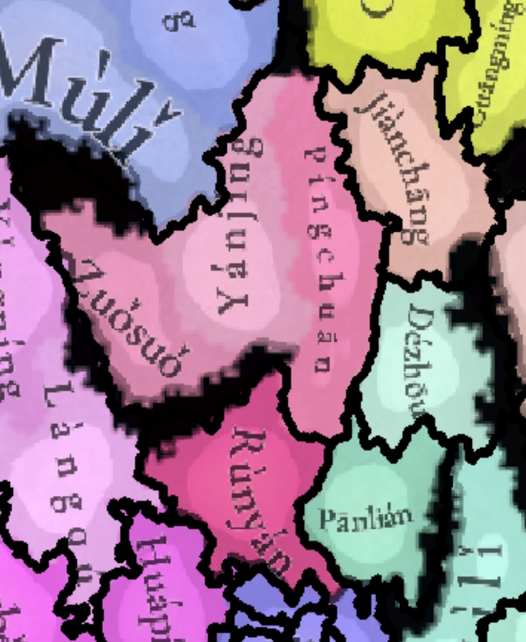
In the early Ming Dynasty, a military post was established at Yanjing Guard (鹽井衛), while the surrounding areas were ruled by Mosuo (Nakhi) people, e.g. the Tusi of Yousuo (右所) in modern Yousuo township of Yanyuan county, Mala (馬剌) in Yanbian county, so I think these locations should not be uncolonized. I suggest to add a Yanjing tag including the Zuosuo, Yanjing, Pingchuan and Runyan locations.
 
Last edited:
  • 3Like
  • 1
Reactions:
View attachment 1222823
In the early Ming Dynasty, a military post was established at Yanjing Guard (鹽井衛), while the surrounding areas were ruled by Mosuo (Nakhi) people, e.g. the Tusi of Yousuo (右所) in modern Yousuo township of Yanyuan county, Mala (馬剌) in Yanbian county, so I think these locations should not be uncolonized. I suggest to add a Yanjing tag including the Zuosuo, Yanjing, Pingchuan and Runyan locations.
Alright, I've incorporated it into my suggestion post.
 
  • 1Like
Reactions:
View attachment 1222870

Reddish-brown - Nakhi
Yellow - Dai
Teal - Hani
Sky-Blue - Bai
Lavender - Zhuang
Blue - Miao
Deep Blue - Kam
Brown - Sui
Olive - Tujia
Green - Yi
Tuquoise - Bo

Gyelthang should be Tibetan. An edict in 1362 mentioned Gyelthang and Yangthang as part of the Pacification Commission of Dokhams (朵甘思宣慰司).

Source: 八思巴字蒙古語文獻彙編
gyelthang1.jpg

gyelthang2.jpg


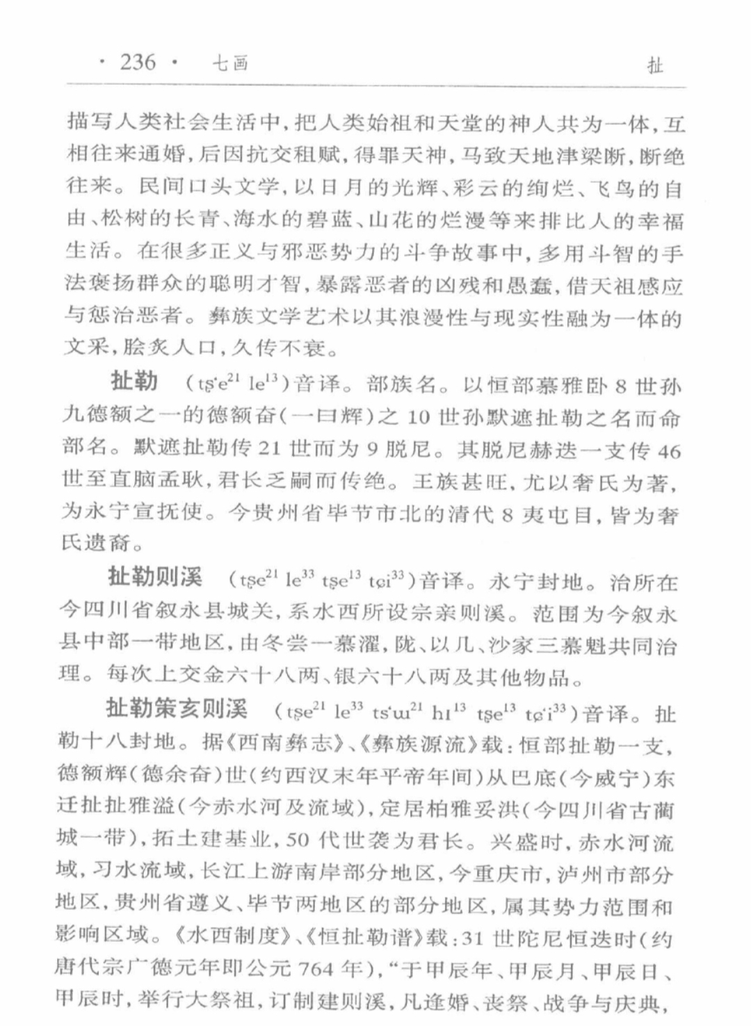
Yongning (Sichuan) should be Yi instead of Miao. The tag can be called Chele (扯勒) in the Yi language, in order to avoid confusion with the other Yongning in Yunnan.

Source: 赫章彝族詞典
chele.jpg
 
  • 2
  • 1Like
Reactions:
Impassable Zones Proposal:

Yellow are existing zones, red are my proposed zones. Black are proposals to delete existing zones. Lakes are marked in blue.

View attachment 1223258

This is based on SulphurAeon's terrain map, and an atlas of China in 1913. Of course, this is a long time after the start date, but at this time, most of China was barely affected by industrialisation, so this map should probably give a good idea of the roadways and routes that existed in Ancient China.

https://collections.lib.uwm.edu/digital/collection/agdm/id/27761/rec/2

In particular, from studying military campaigns in the 17th century, I can relate that the impassable regions depicted on the borders between Jiangxi, Fujian, Zhejiang, and Guangdong reflect the flow of military campaigns in the Ming-Qing wars and the Revolt of the Three Feudatories. The warlord Geng Jingzhong invaded Jiangxi from Fujian in two routes, one in the north into Guangxin, and one in the south into Ganzhou.

It can also be noted that the Manchu invasion of China exclusively used three passes over the Great Wall to enter the Beijing region (as well as retreat from it it after raids south of the wall, which they did multiple times) and did not use any of the others. These were also the main passes used during the Ming dynasty, for example in the Tumu Crisis. These have been left open on the map and the terrain around them blocked off.


The impassable zone on the border between China and Vietnam reflects the 2000 years of recorded history where all recorded Chinese invasions of Vietnam and Vietnamese invasions of China went through one of three places, from Yunnan along the Red River, through Friendship Pass, and along the coast.


So this would help give a very nice historical flavour to wars.

On the other hand, this is a relatively "generous" distribution of impassable regions, so I would certainly welcome feedback if people think there might be too many.

View attachment 1210558
Updated to add some suggested zones to Kham.

1732844826753.png

Gyelthang should be Tibetan. An edict in 1362 mentioned Gyelthang and Yangthang as part of the Pacification Commission of Dokhams (朵甘思宣慰司).

Source: 八思巴字蒙古語文獻彙編
View attachment 1222888
View attachment 1222887

Yongning (Sichuan) should be Yi instead of Miao. The tag can be called Chele (扯勒) in the Yi language, in order to avoid confusion with the other Yongning in Yunnan.

Source: 赫章彝族詞典
View attachment 1222889
Updated my map.
 
Last edited:
  • 7Like
  • 1
Reactions:
Updated to add some suggested zones to Kham.

View attachment 1223259

Updated my map.

View attachment 1938 map.jpgI don't agree with some of the suggested impassables, as they were shown as routes in older maps.

Litang-Sampheling: historically, Sampheling was part of the Principality of Litang. Zhao Erfeng used this route to capture Sampheling in 1906.

Dartsedo-Zhanggu: Zhanggu was part of the Principality of Chakla (明正土司).

Dargyeling-Maerkang: route used during the Jinchuan campaigns.

Markham-Drayab

Zhanggu-Dawu
 
  • 3Like
  • 2
Reactions:
View attachment 1223347I don't agree with some of the suggested impassables, as they were shown as routes in older maps.

Litang-Sampheling: historically, Sampheling was part of the Principality of Litang. Zhao Erfeng used this route to capture Sampheling in 1906.

Dartsedo-Zhanggu: Zhanggu was part of the Principality of Chakla (明正土司).

Dargyeling-Maerkang: route used during the Jinchuan campaigns.

Markham-Drayab

Zhanggu-Dawu
Screenshot 2024-11-28 at 20.46.29.png
 
  • 5Like
Reactions:
Thanks! I have edited my post.

You're correct about Dahou. From what I can find, it might have been one of the polities created after the destruction of Mong Mao? Am not sure.

According to this, Menggu 勐谷 is the autonym/older name of the polity which was designated as Jingdong by the Chinese, so it would be an equivalent of the difference between Shuixi and Mu'ege, I think, and kind of like the difference between Mong Mao and Luchuan.

Also, since the game starts in early 1337, I'd personally say that Mong Mao's subjugation of Hsenwi likely happened slightly after the start date, so it wouldn't begin as a vassal.

View attachment 1223344

(Slightly outdated, see final revisions here)

A couple more changes:
Tai states~2.png


Küngma and Möng Möng replaced with Mengding (Möng Ting / ᥛᥫᥒᥰ ᥖᥤᥒ) and Mouzhan (Möng Hsa / ᥛᥫᥒᥰ ᥔᥣᥴ), which requires splitting the Mengding location. Möng Lem also gets half of Mengdong location.

I've split Yinshaluodian (Möng Ngüm / ᥛᥫᥒᥰ ᥒᥤᥛᥰ) from Möng Lem, but I'm not sure if this was actually a separate polity or just Möng Lem's capital changing? The sources on it seem contradictory or like they overlap.

Chiang Hung should become Keng Hung if they end up being in the Shan dialect.

Removed Shidian/Möng Mo, as far as I can tell it was a part of Dali before Si Kefa's conquests.

Here's also a map of what 'Möng Mao' looked like before Si Kefa:
Tai states_20241129190944~2.png

1. Luchuan (Möng Mao)
2. Pingmian (Möng Wan)
3. Zhenxi (Möng La)
4. Mangshi (Möng Hkawn)
5. Nandian (Möng Ti)
6. Rouyuan (Möng Hkö)
Previously part of Dali:
7. Tengchong (Möng Myen)
8. Yongchang (Wan Sang)

This doesn't need to be included in your map, it's more for the devs to put cores in the right places. I don't think they would necessarily all be "fresh" conquests, some of Si Kefa's predecessors (like Fanghan) governed Pingmian, Zhenxi, Nandian, and Rouyuan in addition to their 'original' Luchuan.

According to this, Menggu 勐谷 is the autonym/older name of the polity which was designated as Jingdong by the Chinese, so it would be an equivalent of the difference between Shuixi and Mu'ege, I think, and kind of like the difference between Mong Mao and Luchuan.
It seems like both were Tai names, Menggu being the name of the valley and Jingdong (Keng Töng) of the capital city, probably the only substantial difference is that I can't find Menggu in Tai script :( but I would guess "Möng Ku"
Screenshot_20241127-235639~2.png


Also, since the game starts in early 1337, I'd personally say that Mong Mao's subjugation of Hsenwi likely happened slightly after the start date, so it wouldn't begin as a vassal.
This also makes sense, perhaps it's something that could be represented by an event since it's so early? Like how they mentioned the Moldavian principalities uniting via event a few years into the game. Not necessarily a "free land" event, but at least a casus belli or fast war. I might make a separate post about this.

There's also a possiblity that Möng Kawng was a subject of Möng Mao already, the ruler Sam Long Hpa came from Möng Mao to establish it as a subject of Möng Mao, some of the Tai chronicles put this event 5 years before Si Kefa ascended the throne while others put it 10 or so years after.
 
Last edited:
  • 2
  • 1Like
Reactions:
Unfortunately, the developers of the game decided to use town names instead of county names. They don't seem to have realised that nobody has ever heard of the town names, and the county names (and names of larger units for big cities) are always used in preference to them. So we need to convince them to correct this mistake.

I have two theories for why they did this. First, the developers probably thought that because counties are technically administrative units that cover a geographic area, they shouldn't be used as names of settlements. But this is actually how all levels of territorial administration in China work. The town is also an administrative unit that is mostly a large rural area with an urban centre that is only a small part of its territory (if the urban centre was a large part of its territory it would be called a 街道 rather than a town). It's still frequently used to apply to that urban centre specifically, but this no less applies to larger units as well.

Secondly, it seems that Google Maps makes it difficult to see county names and preferentially shows names of smaller units. The county borders used by the devs seem to be mostly quite modern (this is especially visible for example in northern Shaanxi), so I suspect that they might have used google maps as a source, and the people working on the China map became accustomed to how it depicts China and did not realise that the universal standard in maps made by people who are actually familiar with China, in both China and the West, for thousands of years (even Marco Polo obeys, for example he referred to Yangzhou as "Yonju", not Jiangdu or Guangling) is to refer to important settlements by the names of counties and prefectures.
I will strongly recommend CHGIS as the best GIS-based mapping references for English users to make historical Chinese map though they are incomplete and the oldest version is only 1820 but they are supported by Harvard University and Fudan University, two of best universities in the US and China.
 
  • 1
Reactions:
  • Table 7-2: Regional Household Data in the Yuan Dynasty (1270)​

    Route/ProvinceYearRegistered Households (A)Population (II)Estimated Households (B)Ratio (A to B, %)
    Zhongshu Sheng1270
    Dadu Lu1270147,590401,350192,00077%
    Shangdu Lu127041,062118,19169,00060%
    Xinghe Lu12708,97339,49514,00064%
    Yongping Lu127013,51935,30012,680107%
    Dening Lu1270
    Jingzhou Lu1270
    Qinxian Lu1270
    Jining Lu1270
    Yingchang Lu1270
    Quanning Lu1270
    Ningchang Lu1270
    Shajing Lu1270
    Baoding Lu127075,182139,04075,460100%
    Zhendin Lu1270134,986240,670175,00077%
    Shunde Lu127030,501124,465
    Guangping Lu127014,45669,082
    Zhangde Lu127035,24688,206
    Daming Lu127066,363145,000
    Huaicheng Lu127034,993170,92620,000175%

    Table 7-2: Continued​

    Route/ProvinceYearRegistered Households (A)Population (II)Estimated Households (B)Ratio (A to B, %)
    Lu'an Lu127022,119127,21791,00087%
    Hejian Lu127079,266168,53691,00087%
    Dongping Lu127047,531123,25750,00089%
    Dongchang Lu127033,102125,406
    Jinan Lu127010,54559,81831,00034%
    Caozhou Lu127037,153195,355
    Weizhou Lu127017,31664,23350,00034%
    Gaoyangzhou Lu127019,10423,12133,00056%
    Taizhou Lu12709,54010,79533,00028%
    Dengzhou Lu127024,424156,95233,00074%
    Enzhou Lu127013,47347,34919,50054%
    Guanzhou Lu12705,69723,040
    Yidu Lu127077,164212,502100,00077%
    Jining Lu127063,289164,885100,00063%
    Hanzhou Lu127021,530123,18541,00053%
    Ningyangzhou Lu12705,71315,74316,80034%
    Daming Lu127045,945128,496
    Zhengding Lu127075,404155,32180,00094%
    Pingyang Lu1270120,630270,121143,00084%
    Hening LuMore than 1 million households before and after the Mongol rule

    Liaodong Province​

    Route/ProvinceYearRegistered Households (A)Population (II)Estimated Households (B)Ratio (A to B, %)
    Liaoyang Lu12523,70833,23140,0009%
    Guangning Lu13304,595
    Dading Lu125246,006448,19386,00053%
    Dongjing Lu13305,183
    Shenyang Lu13304,367

    Table 7-2: Continued​

    Route/ProvinceYearRegistered Households (A)Population (II)Estimated Households (B)Ratio (A to B, %)
    Huaiyuan Province
    Fengde Fu129020,02499,95860,000–80,00025–30%
    Ying Lu1290
    Suzhou Lu1290
    Macheng Lu1290
    Shangluo Accounting Office1290
    Xialuo Accounting Office1290
    Sixteen Registration Offices1290

    Zhejiang Province​

    Route/ProvinceYearRegistered Households (A)Population (II)Estimated Households (B)Ratio (A to B, %)
    Hangzhou Lu1290360,8501,834,710
    Huizhou Lu1330254,345
    Jiaxing Lu1290426,6562,245,742221,927190%
    Pingjiang Lu1290466,1582,433,700466,100100%
    Changzhou Lu1290209,7321,020,011211,65299%
    Zhenjiang Lu1290103,315623,644
    Jiading Lu1290103,481504,264
    Songjiang Fu133016,393

    Jiangxi Province​

    Route/ProvinceYearRegistered Households (A)Population (II)Estimated Households (B)Ratio (A to B, %)
    Jiangzhou Lu129053,821300,17754,12599%
    Qianzhou Lu1290241,457511,113
    Raozhou Lu1290108,567543,600
    Fuzhou Lu1290221,1181,077,540
    Shaoxing Lu1290151,234521,588
    Wenzhou Lu1290187,403497,848
    Taizhou Lu1290196,4151,003,833
    Chuzhou Lu1290132,754493,692
    Ningbo Fu1290232,5381,162,690
    Yanzhou Lu1290157,471824,304157,460100%
    Haozhou Lu1290680,2354,036,570290,226234%

    Table 7-2: Continued​

    Route/ProvinceYearRegistered Households (A)Population (II)Estimated Households (B)Ratio (A to B, %)
    Jizhou Lu1290214,5381,072,690226,37995%
    Taiping Lu129076,202446,371
    Cizhou Lu129068,547366,567
    Xingtai Lu1290132,290662,258
    Guangde Lu129056,513339,780
    Hezhou Lu133026,035
    Fuzhou Lu1290799,6943,875,127298,571268%
    Jianzhou Lu1290127,254569,626
    Quanzhou Lu129089,060455,545
    Xinghua Lu129067,739352,534
    Zhenwu Lu129064,127248,761
    Yanping Lu129089,825435,869
    Xunzhou Lu129041,423238,12741,66499%
    Haozhou Lu129021,695101,306

    Jiangxi Province​

    Route/ProvinceYearRegistered Households (A)Population (II)Estimated Households (B)Ratio (A to B, %)
    Longxing Lu1290371,4361,485,744
    Jian'an Lu1290444,0832,220,415
    Ruizhou Lu1290144,572722,302
    Raozhou Lu1290198,563992,815
    Linjiang Lu1290158,348791,740
    Hangzhou Lu1290218,4551,092,275
    Jiangzhou Lu129083,977503,852
    Fenghuang Lu129095,678478,390
    Ganzhou Lu129071,287285,148
    Ji'an Lu129092,223553,338
    Nan'an Lu129050,611303,666
    Nanshi Lu129025,078128,900
    Guangxin Lu1290170,2161,021,296172,28499%
    Xunzhou Lu129019,584176,256
    Huizhou Lu129019,80399,015

    Table 7-2: Continued​

    Route/ProvinceYearRegistered Households (A)Population (II)Estimated Households (B)Ratio (A to B, %)
    Shangxian Lu129010,79253,960
    Huai'an Lu129063,650445,550
    Deqing Lu129012,70532,997
    Guanling Lu129033,33855,429
    Yindezhou Lu12902,000–3,000
    Meizhou Lu12902,47814,8554,00062%
    Qingyuan Lu129019,37396,865
    Fengzhou Lu12902,07710,742
    Xinzhou Lu129011,31667,896
    Guizhou Lu12906,35625,65520,00032%
    Lingzhou Lu12904,1547,14122,00019%
    Qianzhou Lu12901,6588,290

    Hubei Province​

    Route/ProvinceYearRegistered Households (A)Population (II)Estimated Households (B)Ratio (A to B, %)
    Wuchang Lu1290114,632617,118
    Yuezhou Lu1290137,508787,743
    Changde Lu1290206,4251,026,042
    Xiangyang Lu1290209,9891,111,543
    Chenzhou Lu129083,223115,945
    Tanzhou Lu129048,63279,545
    Xingzhou Lu129050,952407,616
    Zhaoqing Fu129014,48640,866
    Yangzhou Lu12907,49210,964
    Jianning Lu129026,59465,955
    Daming Lu1290603,5011,081,010
    Hengzhou Lu1290113,373207,523

    Table 7-2: Continued​

    Route/ProvinceYearRegistered Households (A)Population (II)Estimated Households (B)Ratio (A to B, %)
    Wufeng Lu129077,207356,863
    Guizhou Lu129065,057102,204
    Xiangyangzhou Lu129036,642177,202
    Suizhou Lu129025,311110,010
    Changning Lu129018,43169,402
    Jingjiang Lu1290210,8521,352,678
    Nanfeng Lu129010,54224,520
    Shouxian Lu12905,20010,910
    Juzhou Lu12909,24830,08915,00062%
    Liuzhou Lu129019,14330,69428,00069%
    Qingjiang Tixing Si129026,53750,253
    Pingle Fu12907,06733,820
    Duzhou Lu12909,05351,528
    Rongzhou Lu12902,9997,854
    Xiangzhou Lu129019,55892,126
    Songzhou Lu12906,24838,879
    Hengzhou Lu12904,09831,4765,69272%
    Rongzhou Lu129021,39339,334
    Tengzhou Lu12904,29511,128
    Hezhou Lu12908,67639,235
    Guizhou Lu12908,89120,81110,88082%
    Sibinzhou Lu12904,22918,510
    Taiping Lu12905,31922,186
    Tianzhou Lu12902,99118,901
    Lai'an Lu1290
    Zhen'an Lu1290
    Leizhou Lu129089,535125,310
    Huazhou Lu129019,74952,317
    Gaozhou Lu129014,67543,493
    Qianzhou Lu129013,55961,39317,28078%
    Cangzhou Lu12905,99811,686

    Table 7-2: Final Section​

    Route/ProvinceYearRegistered Households (A)Population (II)Estimated Households (B)Ratio (A to B, %)
    Qianning Anfusi129075,837128,184
    Nanning Jun12909,62723,652
    Wanzhou Jun12905,3418,686
    Jiyang Jun12901,4395,735
    Dingyuan Fu1290
I found a table from 中国人口史 Demographic History of China (vol. 3, in Chinese) that record province-level population data. The source A is from 元史 History of Yuan's records and the source B is alternative sources for reference. The population is modern estimate based on the household counts. The table above is a unrevised OCR result and the original copy is listed as below.

1732955189693.png
1732955202891.png
1732955210408.png
1732955219790.png
1732955228103.png
1732955235130.png
1732955241498.png
 
  • 5
  • 2Love
  • 1Like
Reactions:

Data from the First Image: Population Density by Administrative Division in the 26th Year of Hongwu (1393)​

Units:​

  • Area: Square kilometers (km²)
  • Population: 10,000 people
  • Population Density: People per km²
This table is from Vol 4 of the same book.

Capital Region (京师)

RegionArea (km²)Civil PopulationMilitary PopulationTotal PopulationPopulation Density
Ying Tian Fu9183140.170.6210.7229.4
Zhenjiang Fu361652.00.052.0144.4
Changzhou Fu646546.70.046.772.3
Suzhou Fu8627235.55.0240.5278.8
Songjiang Fu4214122.60.1123.7291.0
Total32,731629.677.7706.9220.0

RegionArea (km²)Civil PopulationMilitary PopulationTotal PopulationPopulation Density
Yangzhou Fu20,56079.45.084.441.1
Huai’an Fu29,02374.16.781.127.9
Xuzhou Fu10,29021.61.723.322.6
Total59,873175.113.4188.531.5

RegionArea (km²)Civil PopulationMilitary PopulationTotal PopulationPopulation Density
Fengyang Fu57,15042.718.861.510.8
Hezhou and Lihu Fu747310.41.712.116.2
Luzhou Fu24,27043.10.043.117.8
Anqing Fu14,86043.01.744.730.1
Total103,753139.222.2161.415.6

RegionArea (km²)Civil PopulationMilitary PopulationTotal PopulationPopulation Density
Chizhou Fu10,30019.91.721.621.0
Taiping Fu31472.90.02.99.2
Guangde Fu35216.00.06.017.0
Ningguo Fu11,50059.31.761.053.0
Huizhou Fu14,03019.51.721.215.1
Total39,068188.95.1192.348.6

Zhejiang Region

RegionArea (km²)Civil PopulationMilitary PopulationTotal PopulationPopulation Density
Hangzhou Fu7774108.13.7111.8143.8
RegionArea (km²)Civil PopulationMilitary PopulationTotal PopulationPopulation Density
Huzhou Fu6219120.00.3120.3193.4
Jiaxing Fu3276163.82.0165.8506.1
Shaoxing Fu9402133.53.0136.5145.1
Ningbo Fu6337159.30.4159.7252.0
Jinhua Fu9824128.01.0129.0131.3
Wenzhou Fu11,10189.15.094.184.9
Taizhou Fu11,27098.75.0103.792.0
Yanzhou Fu829153.30.053.364.3
Chuzhou Fu18,14069.70.069.738.4
Quzhou Fu927953.70.053.757.9
Total100,9131084.229.71113.9110.4

Jiangxi Region

RegionArea (km²)Civil PopulationMilitary PopulationTotal PopulationPopulation Density
Nanchang Fu22,100111.41.7113.151.2
Ganzhou Fu15,45092.10.092.159.6
Ji'an Fu63508.50.08.513.4
Nan'an Fu517719.60.019.637.9
Ruizhou Fu548242.00.042.076.6
Raozhou Fu878138.30.138.443.8
Linjiang Fu561055.30.055.398.8
Jiujiang Fu10,390120.20.0120.2116.0
Jianchang Fu24,360171.80.0172.870.9
Ji'an Fu836651.30.051.361.7
Guangxin Fu14,07043.60.243.831.1
Xingguo Fu32,2208.60.28.82.7
Nan'an Fu69667.50.07.510.8
Total165,322804.18.0812.149.1

Fujian Region

RegionArea (km²)Civil PopulationMilitary PopulationTotal PopulationPopulation Density
Fuzhou Fu22,74363.48.471.831.6
Jianning Fu18,43069.03.372.339.2
Tingzhou Fu810323.61.725.331.2
RegionArea (km²)Civil PopulationMilitary PopulationTotal PopulationPopulation Density
Yanping Fu17,78056.02.058.032.6
Xinghua Fu380832.03.335.392.7
Zhangzhou Fu17,96041.03.347.326.3
Quanzhou Fu12,32053.03.356.345.7
Zhangzhou Fu19,34029.12.031.116.1
Total120,484370.127.3397.433.0

Guangdong Region

RegionArea (km²)Civil PopulationMilitary PopulationTotal PopulationPopulation Density
Guangzhou Fu36,192116.812.1128.935.6
Chaozhou Fu20,39844.82.046.822.9
Nanhai Fu47888.70.39.018.8
Shaozhou Fu32,67656.52.458.918.0
Meizhou Fu37,74014.02.016.04.2
Shantou Fu17,97010.30.010.35.7
Gaozhou Fu14,01814.20.314.510.3
Leizhou Fu16,7909.71.711.46.8
Lianzhou Fu805329.11.730.838.2
Qinzhou Fu33,90057.50.758.217.2
Total222,525361.623.5385.117.3

Guangxi Region

RegionArea (km²)Civil PopulationMilitary PopulationTotal PopulationPopulation Density
Guilin Fu19,26038.65.043.622.6
Wuzhou Fu27,61026.80.327.19.8
Liuzhou Fu31,13025.91.727.68.9
Qinzhou Fu11,8207.00.07.05.9
Nanning Fu17,1717.23.310.56.1
Taiping Fu91724.90.04.95.3
Pingle Fu20,5003.00.03.01.5
Juyuan Fu27,9908.20.08.22.9
Other Areas58,31725.00.025.04.3
Total222,970146.610.3156.97.0

Huguang Region

RegionArea (km²)Civil PopulationMilitary PopulationTotal PopulationPopulation Density
Changsha Fu42,46053.73.056.713.4
RegionArea (km²)Civil PopulationMilitary PopulationTotal PopulationPopulation Density
Yuezhou Fu10,00021.81.723.523.5
Changde Fu32,34624.36.030.39.4
Hengzhou Fu23,49030.57.738.216.3
Lingzhou Fu12,97014.00.014.010.8
Shuizhou Fu29,01437.90.037.913.1
Baoqing Fu21,59014.12.516.67.7
Changzhou Fu24,06016.20.416.66.9
Qianzhou Fu10,9207.40.07.46.8
Yongshun/Other Areas12,0918.00.08.06.6
Frontier and Miscellaneous Areas47,59432.00.232.26.8
Total266,535250.032.2282.210.6
RegionArea (km²)Civil PopulationMilitary PopulationTotal PopulationPopulation Density
Wuchang Fu18,97032.03.335.318.6
Hanyang Fu36205.00.05.013.8
Huangzhou Fu20,50074.03.377.337.7
Xiangyang Fu14,7207.00.37.35.0
Jingzhou Fu44,9408.73.312.02.7
Shizhou Fu57,31042.55.748.28.4
Shimen Fu18,75014.02.016.08.5
Total178,810183.217.9201.1

Beiping Region

RegionArea (km²)Civil PopulationMilitary PopulationTotal PopulationPopulation Density
Beiping Fu48,73136.022.258.211.9
Shui Ping Fu11,3607.63.310.99.6
Hejian Fu21,40038.00.038.017.8
Baoding Fu16,45038.00.038.023.1
Zhen Ding Fu27,28080.01.781.729.9
Shun De Fu627517.00.017.027.1
Guang Ping Fu529721.00.021.039.6
Da Ming Fu11,97029.00.029.024.2
Total148,763266.627.2293.819.7

Shandong Region

RegionArea (km²)Civil PopulationMilitary PopulationTotal PopulationPopulation Density
Jinan Fu32,450110.05.0115.035.4
RegionArea (km²)Civil PopulationMilitary PopulationTotal PopulationPopulation Density
Dongchang Fu12,57011.01.712.710.1
Guangping Fu38,970105.01.5106.527.3
Qingzhou Fu30,910188.03.7191.762.0
Yanzhou Fu15,73085.04.389.356.8
Dengzhou Fu18,34092.04.296.252.5
Total148,970591.020.4611.441.0

Henan Region

RegionArea (km²)Civil PopulationMilitary PopulationTotal PopulationPopulation Density
Kaifeng Fu14,460133.78.5142.232.0
Xuzhou Fu606021.31.723.038.0
Henan Fu25,95062.10.062.123.9
Ruining Fu46549.10.39.420.2
Yingde Fu991113.21.714.915.0
Nanyang Fu40,01428.03.331.47.8
Huaiqing Fu33,94021.53.324.87.3
Total164,989291.125.3316.419.2

Shanxi Region

RegionArea (km²)Civil PopulationMilitary PopulationTotal PopulationPopulation Density
Taiyuan Fu59,81092.19.4101.517.0
Datong Fu30,85017.725.042.713.8
Zezhou Fu58829.50.09.516.1
Jizhou Fu465724.00.024.052.0
Linfen Fu527010.20.310.519.9
Yuncheng Fu864547.11.749.056.7
Xianyang Fu961837.01.038.039.5
Pingyang Fu37,710147.91.2149.139.7
Total162,442386.038.1424.126.1

Shaanxi Region

RegionArea (km²)Civil PopulationMilitary PopulationTotal PopulationPopulation Density
Xi’an Fu57,100136.011.8147.825.9
Fengxiang Fu13,88024.00.024.017.3
Yan’an Fu66,96041.08.349.37.4
Total137,940201.020.1221.116.0

RegionArea (km²)Civil PopulationMilitary PopulationTotal PopulationPopulation Density
Qingyang Fu20,8109.01.710.75.1
Pingliang Fu36,48019.01.720.75.7
Jinglu Fu50,60025.03.328.35.6
Linxia Fu37,7405.03.38.32.2
Hanzhong Fu50,6506.01.77.71.5
Total334,220265.031.8296.88.9

Sichuan Region

RegionArea (km²)Civil PopulationMilitary PopulationTotal PopulationPopulation Density
Chengdu Fu37,25022.115.537.610.1
Mianzhou Fu43,1206.50.06.51.5
Baoning Fu33,7405.01.76.72.0
Shunqing Fu17,8306.50.06.53.7
Jiading Fu16,8206.00.06.03.6
Yazhou Fu29723.30.03.311.1
Chongqing Fu54,62036.41.738.17.0
Luzhou Fu74609.61.711.315.1
Xuzhou Fu14,03019.51.721.215.1
Jiadingzhou Fu12,4606.80.06.85.5
Total240,302126.820.6147.46.1

Border and Peripheral Areas

(R.M.C = regional military commission)
RegionArea (km²)Civil PopulationMilitary PopulationTotal PopulationPopulation Density
Taiwan36,00010.00.010.02.8
Bozhou27,81312.00.012.04.3
Guizhou RMC71,87630.028.358.38.1
Yunnan362,20984.036.0120.03.3
Guizhou Censorate33,28112.01.713.74.1
Mahu Tusi52,08612.00.012.02.3
Sichuan RMC45,8303.70.03.70.8
Long’an Tusi22,6630.00.00.00.0
Songpan Garrison38,8400.07.77.72.0
Tibet1,880,74080.00.080.00.4
Beshbalik1,919,57530.00.030.00.2
Anding Garrisons454,4754.00.04.00.1
Total3,946,588277.773.7351.40.1
RegionArea (km²)Civil PopulationMilitary PopulationTotal PopulationPopulation Density
Shaanxi RMC81,7695.018.523.52.9
Taozhou & Minzhou Garrisons35,6101.03.34.31.2
Ningxia RMC29,1001.80.92.70.9
Mongolia4,212,13236.00.036.00.1
Beiping RMC162,7980.045.045.02.8
Liaodong68,14410.040.050.07.3
Nurgan RMC3,000,00050.090.7140.70.05
Total5,258,553103.8198.4302.20.5
 

Attachments

  • 1732957204581.png
    1732957204581.png
    38 KB · Views: 0
  • 1732957200751.png
    1732957200751.png
    108,5 KB · Views: 0
  • 1732957191086.png
    1732957191086.png
    102 KB · Views: 0
  • 1732957183303.png
    1732957183303.png
    110,8 KB · Views: 0
  • 1732957179019.png
    1732957179019.png
    111,7 KB · Views: 0
  • 1732957174902.png
    1732957174902.png
    98,3 KB · Views: 0
  • 1732957187642.png
    1732957187642.png
    109,8 KB · Views: 0
Last edited:
  • 5Like
  • 3
  • 1Love
Reactions:
Update about military and ethnical population in Border and Peripheral Areas during Hongwu Era (1368-1399):
The content was quoted from Vol 4 for clarification of the last section in the previous post.
  • Liaodong RMC
    • military & their families- 286k (1391) -> 386k (1395)
      • Surrender from Yuan - 100k
    • civilian -> military auxiliary - 100k
    • Mongols - 100k
    • Jurchen - 40k
    • Korean - 40k
  • Nurgan RMC
    • Jianzhou Left Garrison (Odoli) - 7250 (1421, 1000 soldiers and 6250 women & children)
    • The total was calculated based on Jianzhou Left Garrison's data and the number of garrisons (384)
  • Mongols
    • Northern Yuan
      • About 300k retreated to Mongolia in the fall of Yuan
      • In 1388, 200k population under Naghachu surrended
      • 100k were under Uskhal Khan Tögüs Temür around Hulunbuir
    • Uriankhai Garrisons - at most 50k
    • Beshbalik
      • Hami - 30k - 40k (mid-15th Century)
  • Beiping RMC
    • military & their families - 150k
    • Including 200k population under Naghachu after 1388
  • Shanxi RMC
    • Wanquan
      • military & their families - 100k
      • civilian -> military auxiliary - 25k
    • Datong - Shanxi Branch RMC
      • civilian -> military - 20k
      • civilian -> military auxiliary - 26k - 32k
  • Shaanxi RMC
    • Ningxia Garrisons
      • military & families - 69k
      • military auxiliary & natives - 18k
    • Suide Garrison
      • military - 22k (half from natives)
    • Yaozhou Garrison & Minzhou Garrison
      • military & families - 50k (all natives)
      • military auxiliary - 30k
      • Considerable but unclear size of natives
    • Shaanxi Branch RMC (Ganzhou & Hezhou)
      • Civil (All native) - 50k
      • Guanwai Eight Garrison (excl. Hami) - 30k - 40k
  • Sichuan Branch RMC
    • Songpan Garrison
      • civilian (civilized natives)- 21k
      • ethnical - 60k - 70k
    • Sichuan Deputy RMC (Luoluosi Xuanwei Si)
      • civilian - 67k
      • Tibetan - 40k - 50k
  • Guizhou (incl. Bozhou) - considerable unregistered pop
    • Military & families - 420k
    • Censorate
      • 200k Han Chinese under Huguang Province
      • 640k ethnical
  • Yunnan
    • Military & families - 360k
    • military auxiliary - 90k
    • Civilian - 850k
      • Registered 250k
      • Unregistered 600k - more likely to be ethnical
1733212720913.png
 
Last edited:
  • 6Like
  • 3
Reactions:
I notice some strange legumes production areas in the northwest. In theory, these areas can't produce legmunes or produce only a few centuries ago. Also, there is some wheat production around Lower Yangtze, while in real-world, the wheat and rice was divided by Qianlin-Huaihe Line so you won't grow wheat in the Yangtze Basin. Futhermore, I don't think we have any fur production in Southeastern China.
1733000997631.png
1732999985059.png
1733010799933.png

Maps of cropping patterns in China during 2015–2021
Also for gems distribution in China, I have a map from (Yu et al., 2021). However, I have to emphasize the most valuable gems in China, that are different from the West, were Jades and Yellow or Green Jadites such as emeralds, turquoise, malachite, etc. For details, see https://intl.dpm.org.cn/galleries/details/319.html (Forbidden City's Jewelry Collection)

I will propose a series of gem production places including Hotan Jade, Lin'an (Wild Game -> Gems), Xun, Zhuxi, Xunxi (Rice, Livestock, Fur -> Gems), Nanyang (Fruit -> Gems), Lantian (Lumber -> Gem). Though Nanjing is nicked Stone City, I don't think they produce Stone anyway. A local gem named Yuhuan Stone is well-known in China. Baoshan is also a major production base for South Red Agate. Additionally, I am suprised that Dali Kingdom did not have any marble production as in Chinese we refer Marble as Dalishi, literally stone from dali. For me, the major production in Nanjing can be cotton or silk, notably Nankeen.
1733001347749.png
1733005581169.png

As for Dye production, it varies on colors. According to (Tang, 2023) and the Silk Museum, Yellow was processed from Sophora japonica under Legumes, majorly from the Loess Plateau; Indigo is mainly Polygonum tinctorium Ait. and Isatis tinctoria Linnaeus, which also grows as herbs; Madders were widely used as the sources for red colorants. Most of the dyes were made from plants, many of which were also grown for Chinese medicine, notably Banlangen. Based on my observation, dye is not a kind of raw materials in China but a by-product of herbs or corps.
1733008241205.png
1733008408564.png

Distribution of Rubia cordifolia, a major material for red colorants in Eastern Asia and its theoritical suitable planting area in China.
1733009787586.png

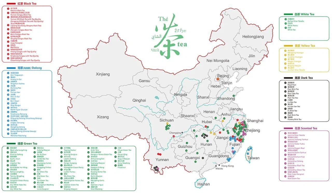
Map of Teas in China.
1733010137823.png

Map of salt mines and oil drilling

List of Gold Mines: https://www.mindat.org/locentries.php?p=693&m=52454
List of Iron Mines: https://www.mindat.org/locentries.php?p=693&m=52466
List of Lead Mines: https://www.mindat.org/locentries.php?p=693&m=52471
 

Attachments

  • 1732999829195.png
    1732999829195.png
    1,1 MB · Views: 0
  • 1733000896438.png
    1733000896438.png
    808,9 KB · Views: 0
Last edited:
  • 10Like
  • 5
  • 1
Reactions:
Another map for Song Dynasty government bussiness taxation and government-run mines in 1140 (中国城市及其文明的演变. (2010). China: 世界图书出版公司.), which I believe it's useful for Trade Center design and mine setting. The right picture shows the population estimates for Yuan and Ming Dynasty based on (Zhao & Xie, 1988). (Columns left to right: Dynasty, Year, Number of Fu, Number of Counties, Total Population)
885.JPG
1733289420926.png

MineralNumber of SmeltersMining Locations
Gold11 smeltersDengzhou, Laizhou, Shangzhou, Raozhou, Bianzhou, Nan'enzhou
Silver84 smeltersDengzhou, Weizhou, Qinzhou, Fengzhou, Shangzhou, Shanzhou, Yuezhou, Huizhou, Raozhou, Xinzhou, Guozhou, Yizhou, Hengzhou, Tanzhou, Bianzhou, Quanzhou, Fuzhou, Jianzhou, Nan'jianzhou, Yingzhou, Shaozhou, Lianzhou, Chunzhou, Nan'anzhou, Jianchangzhou, Shaowu Military Post, Guiyang Mine Administration
Copper46 smeltersRaozhou, Xinzhou, Guozhou, Jianzhou, Tanzhou, Bianzhou, Quanzhou, Nan'jianzhou, Shaozhou, Yingzhou, Zizhou, Shaowu Military Post
Iron77 smeltersDengzhou, Laizhou, Xuzhou, Shangzhou, Fengxiangzhou, Shanzhou, Yizhou, Weizhou, Dengzhou, Cizhou, Guozhou, Jizhou, Yuanzhou, Xinzhou, Tanzhou, Bianzhou, Quanzhou, Jianzhou, Nan'jianzhou, Yingzhou, Shaozhou, Quzhou, Hezi Prefecture, Xingguozhou, Shaowu Military Post
Lead30 smeltersYuezhou, Huizhou, Xinzhou, Bianzhou, Nan'jianzhou, Yingzhou, Shaozhou, Lianzhou, Chunzhou, Shaowu Military Post
Tin16 smeltersShangzhou, Weizhou, Yuzhou, Daozhou, Chaozhou, Hezhou, Xunzhou
Cinnabar2 smeltersShangzhou, Yizhou
Mercury5 smeltersQinzhou, Fengzhou, Shangzhou, Shanzhou
The pictures below show the commercial taxation agency setting in Hongwu (1368-1398) and Wanli (1572-1620) periods of Ming Dynasty, basically the dynasty lost their control of commercial tax. (韓藝丹(2024)。從稅網到榷關:明代商稅徵收「由密到疏」的演變。中國文化研究所學報,(78),37-86 https://doi.org/10.29708/JCS.CUHK.202401_(78).0002)The map is based on CHGIS data which I strongly recommended to use and extracted 1337 and 1393 data from the database.
1733289759527.png
1733289782358.png
 

Attachments

  • Ming1393Prefs.zip
    2,5 MB · Views: 0
  • Yuan1337Prefs.zip
    2,5 MB · Views: 0
Last edited:
  • 10Like
  • 2
  • 1Love
Reactions:
Burma/Yunnan suggestions, continued

Reposting the maps here too since it covers both regions, see above post in the South East Asia thread for all the deils.

Better Shan/Dai culture split (colours represent some of the smaller subgroups)
Tai cultures2_20250120183003.jpg

Splitting between Northern and Southern Shan along with the rest of their subgroups isn't easy, so they could reasonably just be one culture. Tai Lü is much more different.

Non-Tai cultures (only really relevant for Achang, Lisu, and Jingpo)
Other cultures_20241208093240.png
 
Last edited:
  • 8Like
  • 1Love
Reactions: