• We have updated our Community Code of Conduct. Please read through the new rules for the forum that are an integral part of Paradox Interactive’s User Agreement.

Tinto Maps #27 - 22nd of November 2024 - Oceania

Hello, and welcome to another Friday devoted to map worship! You may remember me, Pavía, from previous Tinto Maps, as @Roger Corominas has been dutifully taking care of the last 6 dev diaries. Now he’s focusing on some other tasks, and I’ll be in charge of the last 4, as it’s planned that the war Tinto Maps will be over by Christmas. This doesn’t mean that we will be done with the maps of Project Caesar, though - we will continue posting Tinto Maps Feedback posts in the next few months. And the next one will be a very much anticipated one - the Balkans, next week! But let’s focus now on today’s region: Oceania!

Countries
Countries.jpg

A bit different map today, as there are no regular countries in the entire region… All of them are Societies of Pops! Also, down to the right, that is not ‘Linear Atlantis’, but our ‘3D Material Testing Island’, where our (great) 3D artists test how the different combinations of terrains look in-game.

It may be relevant to repeat our guidelines for how to categorize countries and societies, by the way:

  • Settled Countries (State Societies)
    • Organized through States, which implies a public power holding:
      • Monopoly of violence
      • Tax collection
      • Public works
      • Writing/record-keeping systems
  • Societies of Pops (Stateless Societies)
    • Societies lacking a State properly, but that have some complex organizational features, such as (not necessarily all, but some):
      • Chiefdomly authority
      • Permanent settlements
      • Agricultural development
      • Some kind of taxation
  • Non-Tag Cultures (Bands/Kin Groups)
    • Simple societies, usually hunter-gatherers or shifting agriculturalists, don't organize around power structures, but through horizontal ones
    • Their pops won't be part of any type of tag, akin to EU4 natives

Societies of Pops

SoPs1.jpg

SoPs2.jpg

SoPs3.jpg

There are a few Societies of Pops in Oceania, in three main hubs: Hawaii, Fiji-Samoa-Tonga, and New Zealand. We’d be interested in listening to your feedback on this matter, nonetheless.

Locations
Locations 1.jpg

Locations 2.jpg

Locations 3.jpg

Locations 4.jpg

Locations 5.jpg

Locations 6.jpg

Locations 7.jpg

Locations 8.jpg

Locations 9.jpg
Plenty of different maps today, to be able to show as many different regions as possible. This is very highly WIP, and some of the islands may end up dying because of their size and being unimportant. By the way, you may notice that some of the islands are weirdly rounded up - that’s because they have a different type of terrain, ‘Atoll’, which is the last one that we were able to add to the game in due time during the development process.

Provinces
Provinces1.jpg

Provinces2.jpg

Provinces3.jpg


Areas
Areas.jpg


Terrain
Climate.jpg

Topography.jpg

Vegetation.jpg

Now you may fully notice the purpose of Terrain Testing Island!

Development
Development.jpg

Not a very developed region in 1337…

Natural Harbors
Natural Harbors1.jpg

Natural Harbors2.jpg

There are some very good natural harbors in the region, including a very infamous one in O’ahu…
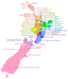
Cultures
Cultures.jpg

Cultures2.jpg

Cultures3.jpg

Cultures4.jpg

Tons of different cultures today!

Languages
Languages1.jpg

Languages2.jpg

Papua is not the most homogeneous place in the world, language-related…

Religions
Religions.jpg

As mentioned last week, we’ve split Animism into several ‘cultural confessions’, which we want now to recombine into broader families; so, again, any suggestions are welcome!

Raw Materials
Raw Materials1.jpg

Raw Materials2.jpg

Raw Materials3.jpg

Raw Materials4.jpg

Raw Materials5.jpg

Raw Materials6.jpg
Resources are, in general terms, quite basic, food-oriented ones; although Australia is more varied, obviously, and there are some areas very rich in Pearls.

Markets
Markets.jpg

Ternate is the main market of the western part of the region, although you may notice that there’s very little access in most of the locations.

Population
There are some issues with the Population distribution map of the region this week, but I’m letting you know that the total population is 1.885M.

And that is all for today! If you want a more detailed map of a given area, just let me know, as I’m aware that the scale of the region shown doesn’t fit well with the usual format of Tinto Maps.

Next week we will take a look at the last continent remaining, starting with the region of North America. See you!
 
  • 148Like
  • 39Love
  • 17
  • 5Haha
  • 5
  • 3
Reactions:
Looking at the maps @Big_birdy posted and satellite imagery, I feel like if the entire coast of of the Great Australian Bight is considered hospitable enough to have locations, a lot more of the interior of Australia should have locations. If you want the game play argument that you should be able to walk along the entire coast, then being able to cross the interior does not seem unreasonable. Having inland locations connected by corridors to each other or the more coastal locations I feel could work.
 
  • 5
Reactions:
Using the terrain map by @Sulphurologist and the vegetation maps provided by @Big_birdy as a guide, I took a stab at redesigning the terrain and vegetation of Tasmania using the existing locations. I am not going to claim that these are the best possible representation of Tasmania but I think it is a lot better than the single hills location surrounded by flatland and the jungle that is what Tasmania gets in this Tinto Maps.
 

Attachments

  • tasmania_terrain.jpg
    tasmania_terrain.jpg
    115,9 KB · Views: 0
  • tasmania_vegetation.jpg
    tasmania_vegetation.jpg
    107,7 KB · Views: 0
  • 4Like
  • 4
  • 1
Reactions:
One iwi didn't dominate the island, so that doesn't need to be explained, Kāi Tahu aren't one Iwi in the sense you mean and north islanders mean by Iwi, it's a nation, a union of a dozen hapu of diverse dialects, traditions and origins under one political/corporate entity. There was a war from early 1600s untilt he 1700s, it was the worst war in pre-colonial history, only Te Rauparaha's raids come close. It ended in the 1780s, and to make sure it never happened again, every hapu intermarried, a system of paramouncy and structured inter-hapu marriage was set up and they were well on to a centralised state before the measles epidemic hit and then the oncoming settlers right on it's heel. There isn't one iwi in the south, Iwi is sort of an arbitrary modern concept on the whole anyway, but Kāi Tahu/Ngāi Tahu are a corporate entity, not one tribe, even today the governance is a complicated negotiated arrangement between Waitaha, Kāti Mamoe, Kāi Tahu and dozens of smaller hapu like the Pahi. Currently they're all agreeing to wear one hat for the sake of land rights and survival but it's not one iwi. it's the southern version of the Kīngitanga it just happened precolonisation so, it's an 'Iwi' now, and everyone just politely pretends marriages in the 1790s-1820s made everyone descended from each other and ignores contradicting land claims and traditions because it's not the time yet.

Good sources are Bill Dacker, Te Mamae me te Aroha, The Pain and the Love it is THE authoritative book on south Māori history although it's mostly focused on colonisation onwards, but really, Kāi Tahu history wasn't accepted academically until less than a decade ago and there is still massive discrimination against those persectives by the establishment, there are still uni's teaching that there are no native Māori in the South Island, just urban transplants from the 60s, the first ever Kāi Tahu reo disseration was last year! that's still the climate, there aren't really books if you want to learn it you got to go out to Otakou (for the Kāi Tahu side) or Oraka (for the Waitaha side) or Arowhenua and ask to learn.
Syd Cormack's Four Generations (which is mostly a fishing memoir) has a fantastic index at the back, and always, Baettie is the greatest primary source, the hocken has most of him scanned up online. but again, it's still pretty oral/unofficial down here because there just isn't the grants or academic support. Tahi Potiki out at Portobello died, two years ago? maybe three, he recorded vast amounts as well. Also there's the missionaries, we have Watkins and Wolher's first hand accounts, and Horomia Pohio's letters if you want to go primary. But again, really if you want to learn it, you learn it in person.

Also the polnesian crops changed over time too, the first places to grow kumera were all in the south, and southland has the microclimate that lets it grow what Otago and Canterbury can't, but reall the little ice age hit the south hard, (which is why Māori migrated north from Wairau Bar to the north in the first place!) so the system of permenant settlements suppliment by season migration loops through maintain forest paths developed unique to the south which is why settlements in the south took a very different shape from northern, and also why southern Māori were so unprepared for the military innovations of Northern Māori when the war happened, both Kāi Tahu and Kāti Mamoe originate as invasions from the NI, which later intregrate in and absorb more populous but less military southern hapu.
Thanks for the links, I’ll have a look. I recognise iwi is more akin to ‘people’ then tribe, and that Ngai Tahu doesn’t cover the entire island. But it does claim most of the island as its takiwa and is larger geographically than any other iwi in the country, even if it is a bit more complex than the attached map suggests.
 

Attachments

  • IMG_0317.png
    IMG_0317.png
    140 KB · Views: 0
  • 2Like
  • 1Love
Reactions:
Firstly, thank for for all the effort you put into such an under appreciated area of the world.

Though I have to ask, why are there so few natural harbours listed in New Zealand? Most notably, Wellington Harbour is one of the most important natural harbours in New Zealand. The name you've listed for the province, "Te Whanganui a Tara" quite literally translates into English as "the great harbour of Tara"!
 
  • 2Like
Reactions:
There should be a harbour in the waihopai province to represent bluff harbour

I’d also like some granularity in New Zealand given the granularity in much smaller areas like Ireland and Greece
 
Last edited:
  • 2Like
Reactions:
I'd like to add my concerns to the pile. I can't say I am expert on the Tonto Empire, but everything I do know suggests they should be a settled, playable tag.

That being said, overall I like this! Well done.
 
the problem is then we have an entire continental landmass with zero reason for existence other than to be colonised. while i understand parity in this regards, i think taking a case by case basis for the regions and approaching what is best approach for that specific region would lead to a healthier player state - because as an Australian rn, an entire continent is empty land to be colonised as of the current plan, and that is beyond a shame

This case by case basis is going to lead to a lot of bias. The only reason people are talking about SOPs in Australia in the first place as opposed to some ethnic groups in Africa that nobody mentioned in the threads, is because Australia nowadays is a developed first world country with a sizeable population- making them part of the audience of PDX games, and as a result active in these forums. As opposed to the people living in Africa, who form a slightly smaller audience and as such didn't get as much attention at all- I was one of the most active people in the West Africa thread and I'm not African. Tinto Talks is already prone to a bit of attention bias as a result of the disparity between audiences, but this is just further reinforcing it.

Putting SOPs in Australia while not putting it in the vast majority of Africa and even in neighbouring Papua New Guinea is a result of a Western bias, not a fair assessment of the world. Of course, things would be different if Tinto did put an SOP in basically most of the world, which I would be in agreement with but that's clearly not their current design policy.
 
  • 10
  • 2Like
  • 1
Reactions:
This case by case basis is going to lead to a lot of bias. The only reason people are talking about SOPs in Australia in the first place as opposed to some ethnic groups in Africa that nobody mentioned in the threads, is because Australia nowadays is a developed first world country with a sizeable population- making them part of the audience of PDX games, and as a result active in these forums. As opposed to the people living in Africa, who form a slightly smaller audience and as such didn't get as much attention at all- I was one of the most active people in the West Africa thread and I'm not African. Tinto Talks is already prone to a bit of attention bias as a result of the disparity between audiences, but this is just further reinforcing it.

Putting SOPs in Australia while not putting it in the vast majority of Africa and even in neighbouring Papua New Guinea is a result of a Western bias, not a fair assessment of the world. Of course, things would be different if Tinto did put an SOP in basically most of the world, which I would be in agreement with but that's clearly not their current design policy.
Idk, I feel like even then suggesting Australian aboriginees were on par development wise with significant chunks of Africa is a bit silly. Eel traps and fishing nets does not a developed society make. It's basically paleolithic tech. And I love paleolithic stuff, I think it's one of the most fascinating periods of human history and there's some amazing works of culture and craftsmanship. But I think pretending that this level of development is to be made on the same playing board as developed states and tribal societies like say, the Comanche or Jurchen is a bit, dare I say, silly.
 
  • 3Like
  • 2
  • 2
Reactions:
Is the term "deep Ocean" still open for negotiation?
View attachment 1219961

I dont know about you, but the only Fleet i wanna send to Deep Ocean, is the enemy one. :D
View attachment 1219962

So perhaps a more nautical term, like High Seas?
You could even structure it like Inland sea, Coastal Sea, Open Sea and High Seas. :)

I work in the maritime field and 1000% agree with the above.
Brief suggestions on minor terminology adjustments, which align much more closely with marine zones/cartography used in modern practice.

Deep Ocean => High Seas
Narrows => Straits
Inland Sea => Internal Waters/Sea
(better encompasses Great Lakes)
Coastal Ocean => Territorial Waters/Sea

Internal/territorial sea might fit PC's vibe better than internal/territorial waters.
That said, modern terminology uses "waters" as these zones are also applied to freshwater/non-"sea" areas (great lakes, caspian, etc.).

One could also use "Archipelagic Waters" if one needs a unique coastal zone separate from "coastal ocean" for gameplay purposes for Polynesian/Indonesian tags.
  • For example, an Indonesian tag might get a unique early advancement enabling navigation of achipelagic waters/coastal ocean, enabling Indonesian tag players to access islands unavailable to, say, Thai/Cambodian/Chinese tags.
  • Alternatively, one could give unlock archipelagic water navigation for all Polynesian/Indonesian tags by default, with advancements later enabling navigation of "coastal ocean." This would let the game better limit how far island communities could extend in the early game. For example, the game might limit Fiji to nearby islands over archipelagic waters while requiring a "coastal ocean" advancement to reach a bit further, before finally unlocking "high seas/deep ocean."
 
Last edited:
  • 3
  • 1Like
Reactions:
Brief suggestions on minor terminology adjustments, which align much more closely with marine zones/cartography used in modern practice.

Deep Ocean => High Seas
Narrows => Straits
Inland Sea => Internal Waters/Sea
(better encompasses Great Lakes)
Coastal Ocean => Territorial Waters/Sea
In PC these are terrain designations, not political ones. With that in mind I think "Territorial" doesn't fit at all compared to "Coastal" and "Internal" is borderline but still sounds more political/legal to me than "Inland."

I'm fine with bringing the game more in alignment with modern practice, as long as it doesn't sound horribly anachronistic, but it should be modern practice as it relates to the natural world (weather, sea conditions, etc), not modern legal practice.

Being near the coast can affect typical sea conditions, being close to sovereign territory can not.
 
  • 3Like
  • 3
Reactions:
Do people here not read the normal Tinto Talks? Society of Pops are playable and can become landed countries.
I guess people really don't read them.
From TT #26:
"Currently though, the gameplay experience is not where we want it, and unless that is improved by beta, they are very likely to be AI only at release."
Pavía also confirmed earlier in this thread that they will very likely not be playable.
 
  • 4
Reactions:
Hi, Melburnian here. Love the detail you've gone into with Australian locations, especially compared to EU4. I have some feedback about the vegetation and terrain maps of Victoria in South-Eastern Australia, and Australia in general.

Mainly, that despite a lot of forest being cleared for farming by Europeans, much of southern Australia was open grassland and open forest/savannah-type biomes prior to colonisation.

1. The Baundig province in Victoria/South Australia could be mostly grassland, based on this being the rough extent of the Victorian Volcanic Plain Grasslands.

2. Gadubamud, south-west of Geelong, could be forest type vegetation and hills terrain (this would represent the Otway Ranges subtropical rainforest).

2. The three south-western locations of province Braiakalung (Wui Wurrung, Boon Wurrung, and Brataulung) should be woods-type vegetation, the rest of this province should be forest.

3. Location Dja-Dja Wurrung should be hills with woods vegetation, to represent the Grampians.

4. Province Tidni should probably be all sparse vegetation or even desert, to represent the Nullarbor plain, which was arid and fairly devoid of vegetation other than saltbush even prior to colonisation.

5. All the jungle vegetation in South-Western Australia should be woods instead (except for the aforementioned Tidni, which should be sparse).

6. In Tasmania, only Toogee should be jungle, the rest should be forest. The two small locations on the north coast of Tasmania (can't read the names, sorry) should be flatlands, but the rest of the island should be all hills (I should know, I've driven across it!).

7. The "jungle" in inland New South Wales should probably be grasslands, and the jungle on the eastern coast south of location Badtjala should probably be woods or forest instead.

8. Some impassable terrain at the highest points/ridges of the Great Dividing Range could be good - they were a significant barrier for the earlier European colonists and explorers.

9. In terms of natural harbors, I would add one to Larrakia in the Northern Territory (to represent Darwin Harbor), one in either Toogee or Paredarerme in Tasmania to represent the wide, calm bays of the mouth of the Derwent River (modern-day Hobart lies mostly on the Toogee side of the river), and one or two across Burrum, Turrbal, and Quandamooka in southern Queensland to represent Moreton Bay (on which Brisbane is situated). The harbor in Kooapudna in South Australia (I'm assuming to represent Franklin Harbour/Cowell?) could be downgraded a level or two, and perhaps add another low-level harbor south of it at location Gnowoo to represent Port Lincoln/Boston Bay.

Thanks, loving these updates, and now I finally have a chance to contribute!
 
Last edited:
  • 4Like
Reactions:
Will there not be any countries to represent the Aboriginal people?

Also, I presume the languages aren't fully done since that's a pretty big lacking of language for such a diverse area irl.
Interestingly enough, the majority of Australian Aboriginal languages are actually in that one big grouping (the Pama-Nyungan language family) - though the languages therein could certainly be subdivided down a bit further - it depends on how granular the devs want to get, as there are at least 250 individual Australian Aboriginal languages.
 

Attachments

  • 300px-Australian_language_families.png
    300px-Australian_language_families.png
    27,6 KB · Views: 0
  • 1Like
Reactions: