• We have updated our Community Code of Conduct. Please read through the new rules for the forum that are an integral part of Paradox Interactive’s User Agreement.

Tinto Maps #30 - 20th of December 2024 - South America

Hello and welcome to one Friday of map-loving! Today is special, as our 30th Tinto Maps, devoted to South America, is the last regular one. This implies that it won’t be the last, though - we plan to have two Tinto Maps Extra on December 27th and January 3rd, and then we will continue with the Tinto Maps Feedback posts as we progress with the map review.

But don’t worry, as on the first post-Christmas Friday, January 10th, I will start a new series, Tinto Flavor, in which we will show the content that we have been working on for Project Caesar. And I promise you, it’s a ton of content, so you will have to play the game in due time to discover it all…

Before we continue, one note: as we're covering a lot of lands today, don't be shy and ask for more detailed maps of the type you want wherever you want them, and I'll try to provide in the replies. And now, let’s start with the South American maps:

Countries
Countries1.png

Countries2.png

Countries3.png

Most of the countries that can be considered being at a State-wise level in 1337 are mostly concentrated in what is today Perú. We have famous ones, as the Chimu or Chincha, and you may also see a tiny country, Qusqu, which would later become the Inca Empire, the long-term goal while playing in the region.

Dynasties
Dynasties1.png

Dynasties2.png


SoPs
Sops1.png

Sops2.png

Sops3.png

Sops4.png

Sops5.png

There are SoPs spread out all across the continent, making for a really interesting mix in the Peruvian area (again). We're already thinking about how to better visualize the coexistence of these two types of countries in the political layer, but it's going to take us some more time to get there.

Locations
Locations1.png

Locations2.png

Locations3.png

Locations4.png

Locations5.png

One note: I'll talk a bit more in-depth about the design of the Brazilian locations if you scroll down, in the Terrain section.

Provinces
Provinces1.png

Provinces2.png

Provinces3.png


Areas
Areas1.png

Areas2.png


Terrain
Climate.png

Topography.png

Vegetation.png

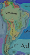
There are huge geographical variations in South America, being one of the most diverse continents. One of the things I wanted to discuss is that we've tried to portray the Mata Atlântica, the original forest cover that was present in Brazil before the Portuguese colonized it, and a different type of land exploitation started. In this regard, we've been reading the feedback of the Brazilian community, and I want to say that our intention here is to portray the most realistic situation for 1337. That said, we've already internally discussed that we may reduce its scope, so it doesn't look so extreme, but we'd like to hear your opinions about it. And here you have one of the images that we used as a reference for it, so you get a good grasp of our intention:
Mata Atlantica.png

Development
Development.png


Natural Harbors
Harbors1.png

Harbors2.png


Culture
Cultures1.png

Cultures2.png

Cultures3.png

Cultures4.png

Cultures5.png

Cultures6.png

The jewel of the crown in this region. We've tried to portray the Pre-Columbian cultural diversity of these lands as accurately as possible, and, well, here you have the results.

Languages
Languages1.png

Languages2.png

Languages3.png

And the languages that group these cultures.

Religions
Religions1.png

Religions2.png

Religions3.png

We've tried to do our best to group the cultural religions of South America into different groups, based on common believes, gods, rituals, etc. Let us know what do you think of them. Oh, also, the Inti religion has its own differentiate mechanics, which we'll explain in the future!

Raw Goods
Raw Materials1.png

Raw Materials2.png

Raw Materials3.png

Raw Materials4.png

Lots of different natural resources in South America. You may note that some are more common compared to other regions (such as Medicaments). We've also been tweaking the color of different resources, with the help of your feedback!

Markets
Markets.png

The green market is centered around Teyuna, and the red one is Chinchay.

Population
Some issues with the map of the region this week (sadly), so let's discuss the numbers. The total in the continent is 10.22M, divided this way:
  • 1.66M in Colombia
  • 1.2M in Brazil
  • 5.07M in Andes
  • 877K in Chaco
  • 1.4M in La Plata
And that's all for today! We hope that you enjoyed the Tinto Maps series! We've definitely done, and it's also greatly helping us to make Project Caesar a much better game, with your help and feedback. Cheers!
 
  • 137Like
  • 57Love
  • 32
  • 9
  • 6
Reactions:
I've seen the suggestion to rename the Tupinamba area to Pindorama (representing the Tupian name for Coastal Brazil, which means "land of palm trees") and I wholeheartedly agree. Some other suggestions I have would be to replace colonial names with native endonyms, particularly the Altiplano, which just means "highlands" in Spanish, and was instead called Qullaw by the Quechua and Aymara. São Francisco, which is the area corresponding to the river with the same name, was named as such by the Portuguese in homage to St. Francis, but the Tupian name for the river is instead Parapĩtinga ("white river"). That's all!
 

Attachments

  • 1734721130017.png
    1734721130017.png
    1,4 MB · Views: 0
  • 14Like
  • 4
  • 2
Reactions:
Yeah sorry to disappoint but the chances of this stuff being represented in game is near 0. Lidar archeology(let alone actual hands on stuff) of the region is still just way too early doors for the Amazon to be covered in game with a goal to make it full of cities. Maybe for Project Caesar 2 electric boogaloo there'll be enough work to change the representation of that region but for PC I don't think there's near enough data collected to be used. It's a game not an archeology journal.
The point that is being made is that we have evidence the area could support large-scale settlements, which disproves the case for it to be a wasteland.
 
  • 6Like
  • 4
Reactions:
Este é um mapa incompleto da minha proposta, veja que (Pará e Mato Grosso não foram feitos) e algumas partes estão em andamento (Rio Grande do Sul). Não diga que fui apologista: Muita gente pediu no começo para acrescentar mais localidades e eu me opus, não porque não quisesse, mas para ficar equilibrado. Veja o terreno intransitável entre Cananéia e Paranaguá (quando pode não ser, mas acho justo) ou no oeste do Maranhão. Garanto que as regiões de São Paulo, Jacareí e Campinas são uma obra-prima.

View attachment Brasil-EU5.png

Note: the map does not open on mobile devices because of its large resolution (10K) To be continued.
 
Last edited:
  • 10Like
  • 7Love
  • 1
  • 1
Reactions:
Hello. Brazilian here.

I am not too knowledgeable on the pre European contact natives of the east coast, but I'd like to share the site of an ONG that lists all currently existing native groups in Brazil. I know those don't correlated that much to groups existing back than, But I hope it can be helpful to you guys:
 
  • 7
  • 1Like
  • 1Love
  • 1
Reactions:
I feel like this part of the Brazilian coastline shoyld have better harbours
View attachment 1233714
The "Tapes" (not sure if this name makes sense) being the best harbor could only be relative to the harbor in the lagoon. However, in the lagoon there are a lot of locations that could be good harbors, like Tapes, for exemple (which is NOT in this weird "tapes" location). On the coast there should be absolutly no good harbor in the Rio Grande do Sul region but surely some harbors in Santa Catarina or Paraná.
 
  • 4Like
  • 1
Reactions:
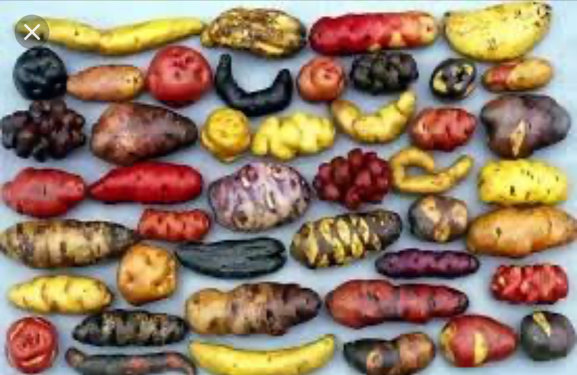
POTATOES? Yes potatoes!!! We need potatoes in the island of chiloe; there is the most genetic diversity land of native potatoes OF THE WORLD !!! chiloe produces a lot off diferents native potatoes. Diferent colors also jeje
IMG_9034.jpeg
 
  • 9Love
  • 3Like
  • 2
Reactions:
  • 6Like
  • 1
Reactions:
If this would help, here are some maps with the historical boundaries of cities in São Paulo in the years 1700 and 1800, as well as a list of when these settlements were founded (the areas along the Tietê river were also used to move up to the hinterlands of São Paulo and Brazil, all the way to the Tietê river - even though there weren't many settlements there):

2558px-Evolu%C3%A7%C3%A3o_da_Divis%C3%A3o_Administrativa_do_Estado_entre_1600_e_1950%2C_Arquivo_P%C3%BAblico_do_Estado_de_S%C3%A3o_Paulo_%282%29.jpg

2560px-Evolu%C3%A7%C3%A3o_da_Divis%C3%A3o_Administrativa_do_Estado_entre_1600_e_1950%2C_Arquivo_P%C3%BAblico_do_Estado_de_S%C3%A3o_Paulo_%284%29.jpg

[1]
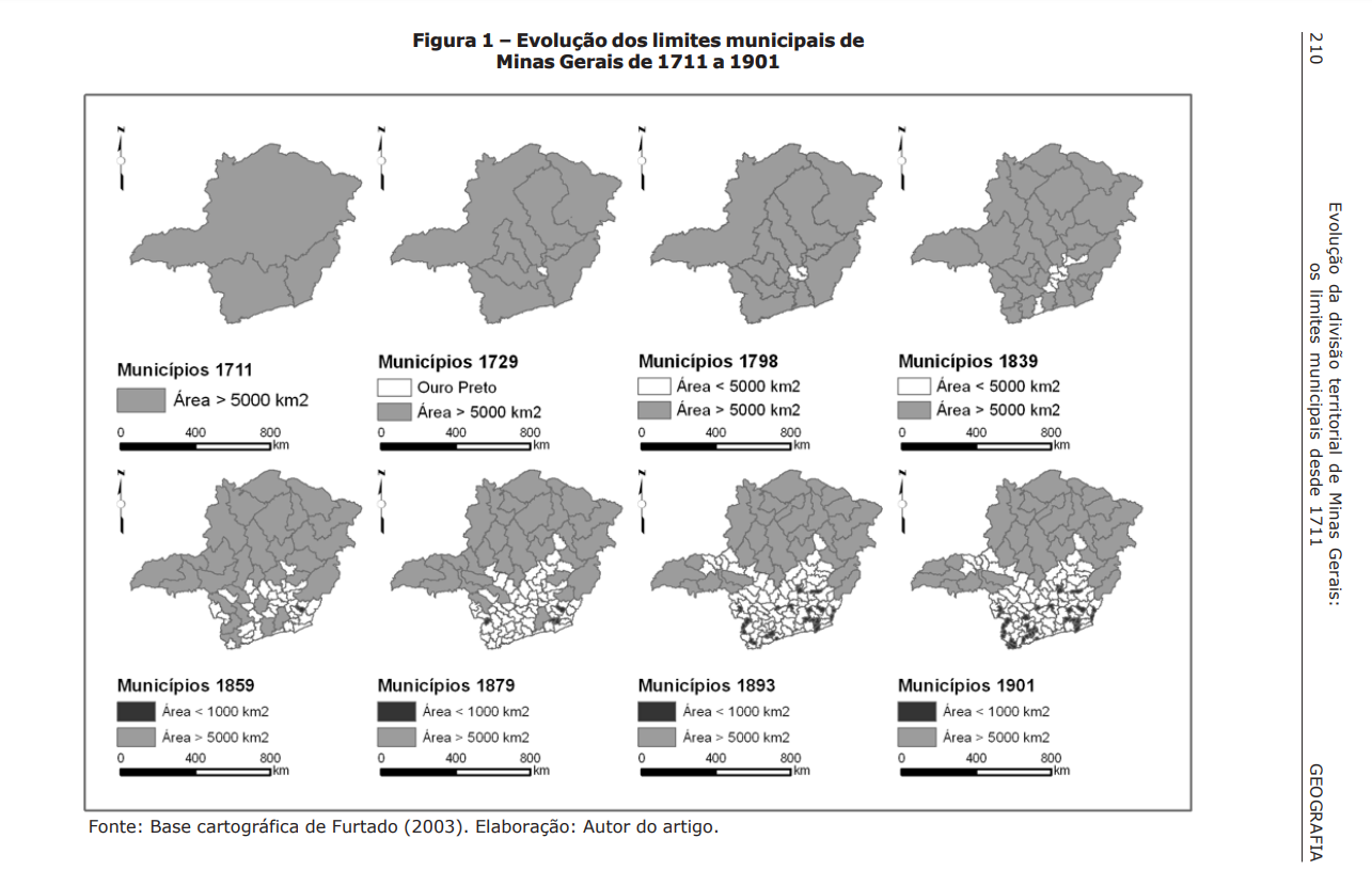
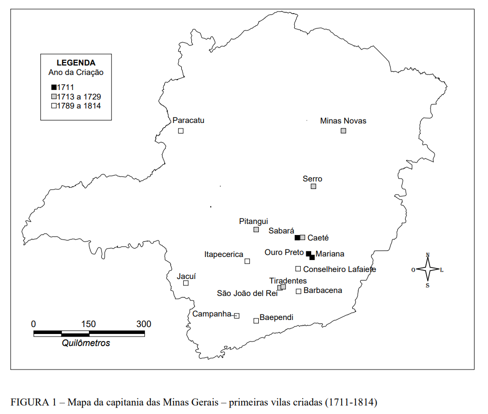
Here's also a useful map of the evolution of comarcas (regions) and municipalities in Minas Gerais - notice how most of them are on central/southern Minas Gerais, as opposed to Project Ceasar map (where most of them are in the West and North, while the most dense areas IRL are wastelands). [2, 3]

Vila do Carmo (Mariana)1711
Vila Rica (Ouro Preto)1711
Sabará1711
São João Del Rei1713-1730
Vila Nova da Rainha (Caeté)1713-1730
Vila do Príncipe (Serro)1713-1730
Pitangui1713-1730
São José Del Rei1713-1730
Bom Sucesso das Minas Novas (Minas Novas)1713-1730
Tamanduá (Tapecerica)1789-1814
Barbacena1789-1814
Queluz (Conselheiro Lafaiete)1789-1814
Paracatu1789-1814
Campanha1789-1814
Baependi1789-1814
Jacuí1789-1814
mg_evolucao_mapa.png


mg_evolucao_mapa2.png

[3]
Sources:
[1] Arquivo Publico de São Paulo: "DEESP (Departamento de Estatística do Estado de São Paulo); Seção de Cartografia; Evolução da Divisão Administrativa do Estado entre 1600 e 1950, contendo: criadores, datas, divisas e sede de comarcas e municípios; Impresso em cartolina"
[2] Bernardo Alves FURTADO, EVOLUÇÃO DA DIVISÃO TERRITORIAL DE MINAS GERAIS:OS LIMITES MUNICIPAIS DESDE 1711
[3] Criação de vilas em Minas Geraisno início do regime monárquico: elementos norteadores gerais
 
Last edited:
  • 13
  • 5Like
  • 2Love
Reactions:
Para los interesados, así es como se ve el mapa de las provincias para los jugadores, con los páramos intransitables distinguidos como entidades nulas al aparecer en gris. La versión con los páramos coloreados por provincia solo está en la versión de depuración para que podamos ver lo que estamos haciendo cuando pintamos el mapa.

View attachment 1233792

The region between Atacama and Jujuy called Puma (like the animal) should be called Puna, which in Quechua means “high ground”.
 
Last edited:
  • 7
  • 3
  • 2Like
Reactions:
One of our coworkers is Uruguayan, so we might have had some mate at the studio... :p

I think that it would be a bit of an outreach to portray it as Tea. What would you think about portraying it as Medicaments?
Mate is basically a cultural simile of caffeine; It is tea for the English or Starbucks for the gringos; Maybe leaving it as a tea is a good option; It is not simply a medicine; It is a cultural necessity. (But I still preferred it to be a separate commercial good; that would be nice for the Paraguayans, Uruguayans, Chileans and Argentines.) coffee and tea are trade good why mate didnt?? Just for native and colonial pops jeje
 
  • 4Like
  • 1
  • 1
Reactions:
And yet gold deposits in other regions, from Alaska to the russian Far East are all already present. Indeed, there was even a dev response about mineral raw goods being represented if they were exploited during the timeframe, so it's still a bit bemusing.
Can't argue against that, gold mining in Minas Gerais precedes Alaskas' for more than two centuries so it doesn't makes much sense
 
  • 11
  • 3Like
Reactions:
If this would help, here are some maps with the historical boundaries of cities in São Paulo in the years 1700 and 1800, as well as a list of when these settlements were founded (the areas along the Tietê river were also used to move up to the hinterlands of São Paulo and Brazil, all the way to the Tietê river - even though there weren't many settlements there):
2558px-Evolu%C3%A7%C3%A3o_da_Divis%C3%A3o_Administrativa_do_Estado_entre_1600_e_1950%2C_Arquivo_P%C3%BAblico_do_Estado_de_S%C3%A3o_Paulo_%282%29.jpg

2560px-Evolu%C3%A7%C3%A3o_da_Divis%C3%A3o_Administrativa_do_Estado_entre_1600_e_1950%2C_Arquivo_P%C3%BAblico_do_Estado_de_S%C3%A3o_Paulo_%284%29.jpg

[1]
Here's also a useful map of the evolution of comarcas (regions) and municipalities in Minas Gerais - notice how most of them are on central/southern Minas Gerais, as opposed to Project Ceasar map (where most of them are in the West and North, while the most dense areas IRL are wastelands). [2, 3]

Vila do Carmo (Mariana)1711
Vila Rica (Ouro Preto)1711
Sabará1711
São João Del Rei1713-1730
Vila Nova da Rainha (Caeté)1713-1730
Vila do Príncipe (Serro)1713-1730
Pitangui1713-1730
São José Del Rei1713-1730
Bom Sucesso das Minas Novas (Minas Novas)1713-1730
Tamanduá (Tapecerica)1789-1814
Barbacena1789-1814
Queluz (Conselheiro Lafaiete)1789-1814
Paracatu1789-1814
Campanha1789-1814
Baependi1789-1814
Jacuí1789-1814
Sources:
[1] Arquivo Publico de São Paulo: "DEESP (Departamento de Estatística do Estado de São Paulo); Seção de Cartografia; Evolução da Divisão Administrativa do Estado entre 1600 e 1950, contendo: criadores, datas, divisas e sede de comarcas e municípios; Impresso em cartolina"
[2] Bernardo Alves FURTADO, EVOLUÇÃO DA DIVISÃO TERRITORIAL DE MINAS GERAIS:OS LIMITES MUNICIPAIS DESDE 1711
[3] Criação de vilas em Minas Geraisno início do regime monárquico: elementos norteadores gerais
Great maps, thanks!
 
  • 23Like
  • 2
  • 1
Reactions:
it is mostly fertile unforested land that is currently responsible for the majority of Brazilian's agricultural output.
The reason why the central highlands now play a major role in Brazilian agriculture is because of extensive State intervention from the 1960s onwards. A massive campaign to de-acidify the soil, together with R&D investment to create crops that could thrive in the savannah. Not to mention the practices brought about by the Green Revolution. So I'm not sure about representing the region as grasslands.
 
  • 7
  • 2
Reactions:
You made the most fertile and richest lands of Brazil, the South and the Southeast, as wastelands?? That makes no sense!

São Paulo and Minas Gerais are one of the most important regions of Brazil, being the most populated regions of the country today, with a lot of Gold to be found in Minas Gerais. The very name of the region means "Mines", because of the gold found there. As such, those regions have been heavily settled and developed in the 17th century. Making it a Wasteland like the Sahara Desert of the Russian tundra is an absurd.
 
  • 13
  • 2Like
  • 1
Reactions:
Fewer locations isn't the same as being more valuable. For example, the base price of spices is much higher, and costs much less to transport than potato (ever bought €10 worth of saffron?). Furthermore, the pop demand for spices is very high across the world which pushes the price up further.
So how will spices be handled??????? Please don't answer "DLC"
 
  • 5
  • 1Like
Reactions:
Neither Argentina nor the United Kingdom invited Tinto to those talks. Therefore we are non-signitories and not bound by the treaty.
The correct way here of course is to say Falklands when talking to an Argentinian and Malvinas when talking to an Englishmen, so that both parties can be pissed off equally.
 
  • 11Haha
  • 2Like
  • 1
Reactions:
The reason why the central highlands now play a major role in Brazilian agriculture is because of extensive State intervention from the 1960s onwards. A massive campaign to de-acidify the soil, together with R&D investment to create crops that could thrive in the savannah. Not to mention the practices brought about by the Green Revolution. So I'm not sure about representing the region as grasslands.
That is true for the very deep interior of the country, like Mato Grosso, Mato Grosso do Sul and Goiás. But the regions near the coast are historically very fertile and heavily settled during colonial times.
Minas Gerais, São Paulo, Paraná, Santa Caratina and Rio Grande do Sul are the most populated, fertile and wealthy regions in Brazil, and that comes back from the colonial times where Coffee, Sugar, Gold and Cattle were produced in vast quantities on those regions. No way this comes even close to be a Wasteland!! On the very contrary, it should be the best areas of the Brazilian lands. Of course, there were huge forests there because of the Mata Atlantica, so just make it very fertile locations with dense forests that can be cut down to open the way for a future powerhouse.
 
  • 12Like
  • 5
  • 1
Reactions: