• We have updated our Community Code of Conduct. Please read through the new rules for the forum that are an integral part of Paradox Interactive’s User Agreement.

Tinto Maps #6 Great Britain & Ireland Feedback

9 September 2024 12 May 2025​


What an exciting week we have had, and best of all I finally get to say the name Europa Universalis V. It still feels weird in my mouth after carefully saying Caesar for what feels like a lifetime.

But lo, the day is finally come for the British Isles feedback thread. This short update was supposed to come out a few months ago, but I just had to teach some of you a lesson. Also I had a lot of other things on, like appearing in the announcement show last week.


Here we see the updated topography:

topography.jpg


The updated vegetation:
vegetation.jpg


Many impassable barriers have been added, for example the various peaks of the Pennines and the Wicklow Mountains. The Shannon also now poses a more significant barrier between east and west Ireland, with only a few crossing points often guarded by stockades.


Here we have the Locations map, bear in mind they are only showing the default English names but many places have Gaelic or Brythonic versions.

locations.jpg


Every country has had a general increase in density.

England, in particular the south, has had a big revamp at Location and Province level to more accurately reflect the historical counties, many of them pre-Norman in origin and many of them still in use today in some form. Westminster as a capital has been killed and rolled into a monolithic London.


Provinces:
provinces.jpg


Areas:

areas.jpg


And political mapmode (with overlord colouring off):
political.png


And Dynasties:
dynasty.jpg


We have added the Earldom of Orkney in the northern isles as a Norwegian vassal. Meanwhile the Palatinate of Durham and Chester have both been promoted from a special set of buildings to vassals under England. Wales has also been limited strictly to the Principality of Wales, with the marcher lords existing as very low control locations under England.

Ireland has had a major rework in terms of locations and tags. Mostly there have been minor Irish chieftaincies added. As always we are grateful to the many suggestions that have come from the forumers.


Culture:
culture.jpg


The most obvious culture change is that English has had Northumbrian split off, to represent the divide between southern and northern dialects and attitudes. A practical example of this is how in the south the English are more friendly to Normans, whereas the Northumbrians hate them (the northern shires still bear the scars of the Harrying of the North). Northumbrians and Scots also spoke a similar form of English in this period, so it helps to set them up as a sort of middleman.

Norwegians in northern Scotland and the nearby North Atlantic have also been split into Norn.


As a bonus, Court Language, showing 3 main worlds: Gaelic, Anglo-French, and Roman Catholic Bishoprics.

court_language.jpg


There have also been some changes to Raw Goods, as you can see here:

raw.jpg


We still have time to make some changes, so let us know what we can do to push this even further towards where it needs to be.

I won’t show Population numbers right now, as it’s pending a proper rework. Among other things, the idea is to reduce the population numbers in England.
 
Last edited:
  • 165Like
  • 78Love
  • 8
  • 5
Reactions:
Wowowo why is the Isle of Man a part of the Hebrides? I understand it's not important enough to be it's own area, but why not have it be part of Northumbria instead? Seems way more fitting.
Maybe they could rename the area to Sodor, another name for the kingdom of man and the isles
 
  • 1
Reactions:
Looks good.

Some discussion points - I am originally from South Tyrone, Northern Ireland for context.

I think its a little odd to have Lisnaskea as a location when Enniskillen makes much more sense to me. The Castle being of ultimate importance to the strategic entry to the lakes, and one of the few gateways between Ulster and the southern provinces.

From a provinces perspective, it seems a little strange to have Tyrone yet no Fermanagh, considering the rivalry between the counties and the dynasties that existed, specifically the O'Neills and Maguires. Same with Oriel and no Armagh - seems strange considering the importance of Armagh religiously to everyone on the Island then and today.

Also the "gateways to ulster" is an interesting topic, and leads me back to Fermanagh and Armagh being important enough to be their own locations. Ulster historically had only 2 places a military force could march through to enter the province from the south. Either through Fermanagh - specifically Enniskillen. Or through the Moyry Pass in Armagh. The rest of the province was shielded by mountains or bog, making it impossible to move and army. Enniskillen was guarded by a castle owned first by the Maguires, then the English. It did change hands a few times, but Enniskillen was a VITAL strategic town. During the Williamite Wars in Ireland (Part of the 9 years war fought on the continent) Enniskillen was crucial. It also has the distinction of being the ONLY town in the entire UK that has 2 unique regiments formed from it, and was key to the events at the siege of Londonderry. The Moyry pass is the only other place in the province, and was key to access to the Pale and Dublin from the North. It is not without reason that Williams army landed at Carrickfergus and pushed south via the pass and were intercepted, leading the battle of the Boyne. I am unsure how it would balance having impassible territory here in Ulster, but its worth a conversation.

Finally - in the English names location and provinces map, I am unsure how I feel about "Derry" when the English name was and continues to officially be Londonderry. It would make absolute sense that when taken by the English it would be named appropriately as it was in the real timeline to Londonderry in 1613. In fact it could lead to some cool events utilising the burghers to invest a sizeable amount into the development of the province, specifically as a port. The city of London crest can still be seen all around the city to this day, and it is one of the oldest and best surviving intact city walls in the UK and Europe. I think for historical accuracy, as well as flavour, a lot more could be done here.
 
Last edited:
  • 4Like
  • 2
Reactions:

9 September 2024 12 May 2025​


What an exciting week we have had, and best of all I finally get to say the name Europa Universalis V. It still feels weird in my mouth after carefully saying Caesar for what feels like a lifetime.

But lo, the day is finally come for the British Isles feedback thread. This short update was supposed to come out a few months ago, but I just had to teach some of you a lesson. Also I had a lot of other things on, like appearing in the announcement show last week.


Here we see the updated topography:

View attachment 1296747


The updated vegetation:
View attachment 1296748


Many impassable barriers have been added, for example the various peaks of the Pennines and the Wicklow Mountains. The Shannon also now poses a more significant barrier between east and west Ireland, with only a few crossing points often guarded by stockades.


Here we have the Locations map, bear in mind they are only showing the default English names but many places have Gaelic or Brythonic versions.

View attachment 1296749


Every country has had a general increase in density.

England, in particular the south, has had a big revamp at Location and Province level to more accurately reflect the historical counties, many of them pre-Norman in origin and many of them still in use today in some form. Westminster as a capital has been killed and rolled into a monolithic London.


Provinces:
View attachment 1296750

Areas:

View attachment 1296948


And political mapmode (with overlord colouring off):
View attachment 1296751


And Dynasties:
View attachment 1296947

We have added the Earldom of Orkney in the northern isles as a Norwegian vassal. Meanwhile the Palatinate of Durham and Chester have both been promoted from a special set of buildings to vassals under England. Wales has also been limited strictly to the Principality of Wales, with the marcher lords existing as very low control locations under England.

Ireland has had a major rework in terms of locations and tags. Mostly there have been minor Irish chieftaincies added. As always we are grateful to the many suggestions that have come from the forumers.


Culture:
View attachment 1296753


The most obvious culture change is that English has had Northumbrian split off, to represent the divide between southern and northern dialects and attitudes. A practical example of this is how in the south the English are more friendly to Normans, whereas the Northumbrians hate them (the northern shires still bear the scars of the Harrying of the North). Northumbrians and Scots also spoke a similar form of English in this period, so it helps to set them up as a sort of middleman.

Norwegians in northern Scotland and the nearby North Atlantic have also been split into Norn.


As a bonus, Court Language, showing 3 main worlds: Gaelic, Anglo-French, and Roman Catholic Bishoprics.

View attachment 1296755


There have also been some changes to Raw Goods, as you can see here:

View attachment 1296756


We still have time to make some changes, so let us know what we can do to push this even further towards where it needs to be.

I won’t show Population numbers right now, as it’s pending a proper rework. Among other things, the idea is to reduce the population numbers in England.
English and Anglo-Irish have the same colour so it is extremely hard to even spot the existence of a separate culture there
 
  • 2Like
Reactions:
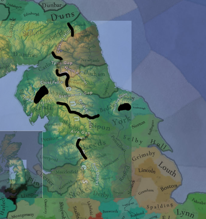
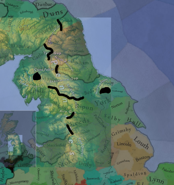
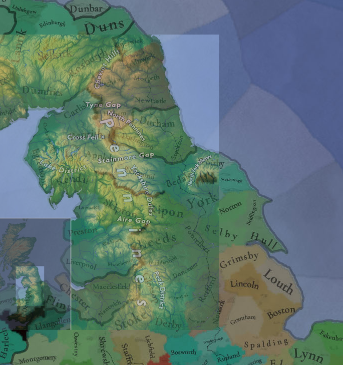
Suggestions for the Pennines

I've previously posted a reason for adding a wasteland between Blackburn and Leeds - due to the topography and to empower the strategic importance of Skipton (during the English Civil War, where trans-pennine army movements between Preston and York went via Skipton because of the "Aire Gap").

Secondly, I have also posted suggestions to alter the wastelands around the Tyne Gap between Carlisle and Newcastle. The set-up currently shows the Tyne Gap as a wasteland whilst the highest point of the Pennines - Cross Fell (between Penrith and Hexham) - as passable. Considering the importance of Carlisle, having it be the "crossroads" between NW England, NE England and Scotland seems more suitable.

Finally, I would suggest extending the "Lake district" wasteland to prevent movement between Cockermouth and Kendal. This would make army movements between Carlisle and Kendal favour moving through Penrith and Appleby - opposed to just Cockermouth. This was the route the Scottish took before the Battle of Preston (1648) as they sieged Appleby Castle and then moved towards Lancaster and Preston. It is also the more direct route.

I would suggest these changes to reflect both historic army movements and geography:
  1. Add Blackburn-Leeds wasteland
  2. Remove Leeds-Skipton wasteland
  3. Add Penrith-Hexham wasteland
  4. Remove Carlisle-Hexham wasteland
  5. Add Cockermouth-Kendal wasteland

suggestions.png


existing wastelands.png
northern topography.png
 
  • 8Like
Reactions:
Added area to the main thread.
View attachment 1296950

Small thing but I think the early modern/modern names for the regions should be applied equally - 'Midlands' and 'the North' superseded the Anglo-Saxon names around the same time as 'the Home Counties' and remained the versions actually used in the UK from the early-modern period right up to today. Other than that, great feedback thread the detail on the county level is mad.
 
  • 2Like
Reactions:
The distinguishment between hills on the UK map seems odd. I can't speak for all examples but Canterbury being considered the same sort of hilly as the Brecon Beacons (highest point being ~886 m), seems odd to say the least.
 
  • 4Like
Reactions:
Great work for perfidious Albion
 
  • 1Like
Reactions:
For everyone suggesting that the province and area maps in Ireland should match the modern counties and four provinces exactly: please keep in mind that the specific boundaries were divisions established by the English monarchy in the 16th and even 17th centuries as they centralised Ireland under their direct control. Before this, most English counties mapped almost exactly onto historical and long-standing Irish political boundaries, as the Anglo-Norman conquest found it far easiest to administer and conduct diplomacy with the Irish on terms they understood.

In 1337, Breifne was a geographic region understood by both the English and Irish as "the rough third of Connacht", and the clans leading the eastern and western halves both saw themselves as rightful owners of the whole thing - and the Ó Conors of Connacht saw both as his rightful subjects.

Modern County Louth was known as County Uriel at the time, and had an indefinite northern boundary, theoretically including the whole kingdom of Airgíalla. Modern County Armagh and Monaghan were just parts of Uriel/Airgíalla England couldn't control.

If anything, there are many cases where the province setup for Ireland is already too modern: County Wicklow was the last county established, in 1606. Until then it was administered (or not administered) as part of County Dublin, which really shouldn't include Navan (one of, if not the most important town in the Liberty of Meath) and Drogheda (which should be in Uriel). Additionally, the Offaly province really should be split entirely, given that it's essentially a wastebasket taxon put together out of border territories explicitly for colonial settlement. Birr was the northernmost town in Munster for the Irish, and rightfully part of County Tipperary for the English. Likewise, Upper Ossory - western Queen's County, only nostalgically renamed Laois on independence - was simply the part of the County/Kingdom of Ossory (later Kilkenny) that the English couldn't control. Dunamase and Daingean were until very recently forts of the Earl of Kildare, and long-standing parts of Leinster for the Irish, and Tullamore was held by the last relatives of the Kings of Meath the English couldn't conquer.
 
  • 8Like
  • 1
Reactions:
Scandinavian
Why'd you disagree why me speculating on what culture groups Norn might be in? Sure it will be in the Scandinavian culture group, but it is a culture native to Scotland, shouldn't it also be a part of the Scottish culture group? And for that matter, the British group as well? And Icelandic, Faroese, and Norn are all insular Norse languages with much in common, why shouldn't they be their own culture group?

Also devs. what culture are the Faroe islands now? I presume they are also Norn, but we don't know.
Edit: rereading "and the nearby North Atlantic" sure sounds like it includes to Faroe islands.
 
Last edited:
  • 1Like
Reactions: