Hello again, its time for another long suggestion thread - this time the research was far more difficult, as details on city history are far scarcer online. A lot of the new locations are suggested based on the importance of the city, but more are added simply to split unduly large or particularly oddly shaped provinces, especially for the inland regions. The division of regions here is quite arbitrary and loosely follows its ancient regions, as I mostly needed to split it up for better readability. The suggestion starts in Cilicia and goes clockwise along the coast, before going west-to-east in the inland regions.
In Anatolia, cities changed names far more often than in Europe, many current names dating back to mere decades ago - this of course further complicates research. Often, we know that areas were settled, but the current cities only became
permanent settlements later into the game's timeline, being inhabited by Turkish nomads before, or they replaced cities whose names we cannot know.
Without further ado:
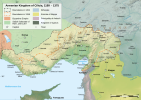
Cilicia
Cilicia benefits from the 1337 start date as much as any other region in the game - instead of Generic Beylik #7, Armenian Cilicia still stands. I expect this region to get a lot of play, so I really tried to improve on it, especially as it was missing many important cities.
A:
Ayas to Genoa
Aigai/Ayas was a very important trading center in the 13th and early 14th centuries, and Cilician Armenia leased parts of it to the Italian merchant republics of Venice, Genoa, and Pisa, with Genoa becoming the dominant one, having a large colony. The city did not fall finally under the Mamluks until 1347 (when the Genovese presence also ended for the first time), so I would represent this by giving the location to Genoa (thus also representing their influence in the region - they also owned a settlement in Alexandretta before it fell to the Mamluks in 1268, and smaller settlements in Tarsus,). It is unlikely it fell to the Mamluk as early as 1337 unless I'm missing some sources, because that is when the significantly more eastern Toprakkale fell. To match its new enclave status, it becomes far smaller and more coastal, ceding land to Toprakkale to account for the below two additions, as well as to the new Ceyhan. Regardless, even if you don't give it to Genoa, it should likely belong to Cilicia before the Mamluks.
1.
Alexandretta (Iskenderun)
This one seems extremely obvious to me - Alexandretta has been one of the most important cities in the region since ancient times, remaining an important commercial center and developing especially again under the later Ottoman rule. Fishing has been an important economic activity for centuries, especially for prawns, so I would give it Fish as the raw tradegood.
2.
Baias (Payas)
Another important port city, I would make Toprakkale a landlocked location by also adding Payas, taken by Mamluks from Cilicia in 1268. Under the Ottomans, it was a major shipyard (crucial to the conquest of Cyprus), a trading center, and had two forts. The location also includes Chork Marzvank/Dortyol, a large town by the end of the timeline. While today it is a big iron and coal processing center, in the period it was more likely to be focused on Fruit growing and fishing - as Alexandretta got Fish, I would give it Fruit.
3.
Myrsine (Mersin)
An ancient city, Mersin is today one of the most important ports in the eastern Mediterranean. While it was less important in this period, Mersin was still a notable city - with a population of 7000 in the mid-19th century. It has been one of the main Cilician cities alongside Tarsus and Adana, so I feel it merits inclusion. The region has mined molybdenum since ancient times, so Lead is the natural tradegood, though the region also produces myrtles (which give it its name, so Fruits/Medicaments?) and Cotton, as well as Olives and Fruit, I'd definitely give the advantage to Lead.
4.
Mopsuestia (Mises, modern Yakapinar)
An important city in the region from the Roman times all through Cilician Armenia, Mopsuestia was still a diocese at the start of the game (though it was nowhere near as relevant as in the 11th century, when it had more than 200 000 people!) and had Italian trading colonies present, only declining after the Muslim conquest, though it remained a large village. The region grows citrus fruits & watermelons, making Fruit a very good option, but it also grows Wheat, Cotton, and Legumes. I would probably go with the Fruit.
5.
Yarsuvat (modern Ceyhan)
Yarsuvat was noted for being a large city in the period (about 5000 in the 14th century!) and had an important caravansarai center nearby, as well as an Armenian and later Mamluk fortress at Tunmlu. Mostly produced Cotton, but also Fruit (watermelons and peanuts) and wheat, though I'd give it Cotton.
Note - what is
C'Axud? I managed to track down Molevon ( as Karakilic near Karaisaili, misplaced here, see below) and Hargan (as Hajin, modern Saimbeyli), but the only reference I found to C'Axud is that it means forest in the Hamshen dialect of Armenian? Regardless, I did not touch the location much for fear of changing something important I'm missing. If it is an error, I would replace it with Bardzerberi - though I was not able to find anything more on it either, apart from the name and being in the location based on maps.
Candir should be
Paperon/Barberon under Armenian rule.
Mokhbud is another castle mentioned in the area, but I did not find more info
B:
Molevon moved to a more correct location
This also reduces the massive size and awkward shape of Sis. In its place, two very important locations are added:
6.
Lampron/Namrun (modern Camliyayla)
One of the most important castles of Cilician Armenia, an absolutely massive castle. The location includes another notable castle in Sinap. The area around Camliyayla is often used for hunting, so Wild Game sounds like a good tradegood, though Livestock is also possible due to goat raising
7.
Gouglak/Kuklak (modern Gulek)
The other most important Cilician fortress, which gave the Turkish name (Gulek Pass) for the Cilician gates, allowing for further fortification of the region. Given the mountainous nature of the region, Livestock seems fitting as a tradegood.
8.
Vahka/Feke
Another important Armenian castle, Vahka was the stronghold of the Roubenid barons that founded the kingdom. It also splits the large Hargan location. Another mountainous location, Livestock or Legumes (chickpeas grown in this region) fits
9.
Antiochetta
Between Selinti and Anamur likes Antiochetta or Antiochia ad Cragum, which was between 1332 and 1357 an enclave of the Knights Hospitaller - I think this would be very interesting to represent! As for the tradegood, a winepress is mentioned to be found in the Roman ruins, and the region could certainly use more Wine, so that's what I'd assign it.
10.
Anaypazar/Dioksisereia (modern Gulnar)
Mut is very large and oddly shaped, so I split off its southern part. The location also includes Zeyne, another old Turkmen city, as well as Uzuncaburc, located at the site of the ancient city of Dioksisereia. Fruit, Wine and Fiber Crops are grown in the region.
If anyone on the team or the forums speaks Armenian, I assume they would find this map very helpful as well:
Caria
The southwestern coast of Anatolia has several surprisingly large locations, split up here
1.
Patara/Kalamaki(Kalkan)/Margaz ? - Louth Lycia
I would love to add a location to this area due to its wealth of ancient remains, but finding one appropriate to the early game period is difficult. Kalamaki is a fishing town that was the only safe harbor between Kas and Fetihye/Megri, and was decently important once founded, however, its founding was only in the 18th/19th century. Patara was a nearby ancient city that remained relevant well into the Middle Ages, but was abandoned around 1340, soon after the start. Further inland, the ancient town of Xanthos (modern Kinik) and its sanctuary at Letoon are found, and to the northwest are Pydnae and Pinara. The only notable settlement I can confirm existed in the early period was Uzumlu near Kalkan, which was then known as Margaz, so that would work as the location name. Would produce Fish given Kalamaki's fishing port status
Milas is huge compared to other coastal provinces, so I have two additions to make from it:
2.
Yoran (Didim)
Another ancient city, just to the south of Balat/Miletus The area around the city primarily grows Olives and figs, but also grows Wheat and Cotton and keeps sheep and goats, so I would give it Fruit or Olives, but of Olives, Cotton, Wheat, Livestock and Wool also work as well
3.
Cine
The larger location added, it covers the inland part of Milas. Cine is near the ancient city of Alabanda. The area has notable sodium, feldspar, and quartz mines, so Alum or Gems work as a tradegood, though Olives and Livestock are also present (and today Cine is well known for its kebab)
4.
Leyne
Another addition is possible between Milas and Mugla, that of Leyne (modern Turgut), representing also the ancient Stratonikeia and Lagina and modern Yatagan. The area mostly produces Wheat and Olives, but is also notable for its lignite mines, giving a rare Coal producing location to the region
5.
Garbikaragac (Acipayam)
A split for the very large Golhisar and oddly shaped inland of Megri, Garbikaragac is the old name for Acipayam. Acipayam is well known for its melons and watermelons in addition to the almonds that give it its name, Fruit is the natural tradegood
6.
Kale
Splitting up Tavas, Kale was an important trade and administrative center in Ottoman times, and succeeded the ancient Tabea. The area mostly grows grain, so Wheat is a good tradegood option
A:
Tavas & Kale to new tag, Tavas
Speaking of Tavas, why is the Tavas principality not represented? It was an independent state in the area between 1243 and 1365. The addition of Kale also serves to buff the new tag
Also minor nitpick, but while Megri is the correct Ottoman name for Fetihye for almost the entire period (as well as an adaptation of its Greek name), the city was known as Beskaza under Mentese rule - is it possible to localize it by tag rather than culture?
7.
Kaunos/Dalyan
Perhaps not the most necessary addition, but I wanted to split the coast of the somewhat large Yuksekkum/Koycegiz location. Kaunos, an ancient Carian city, remained very important through the Middle Ages, before declining in the 14th and 15th centuries and being abandoned in favor of Dalyan. The location also includes Dalarman and Ortaca. The area is well known for Cotton and pomegranate production, so Cotton or Fruit works as a tradegood, with Cotton probably being better as it was more important historically. The nearby port town of Gocek (which could also be its own location) was known for its chromium mines during both ancient and Ottoman times, though not sure what tradegood that would be - Tin? Lead?
8.
Knidos/Datca
The long and odd shape of the Resadiye peninsula allows for the split of Marmaris location, with the addition of Datca (ancient Stadia), and near the important ancient city of Knidos. The area produces Wine and Olives, but is mostly known for its production of Fruit (most notably almonds, but also apricots and plums)
9.
Finike
Kas is very large and Finike was a pretty important city currently missing. Finike is famous for its oranges, the symbol of the city, so Fruit is the obvious tradegood, though Stone is also a good possibility, representing the Limyra quarries (especially if Myra below gets Fruit)
10.
Myra/Kale
Another possible location addition is possible to the west, being Kale (modern Demre, ancient Myra). A pomegranate growing area, Fruit is the obvious tradegood. A less important addition than Finike, however, I feel it is still warranted.
11.
Oguzhan (Bucak)
Isparta and Egridir are both rather large and oddly shaped, so I'm suggesting Oguzhan (modern Bucak) to its south. The location also includes ancient city of Cremna right next to Bucak. The area is well known for many Marble mines, so that is the obvious tradegood.
Ionia
The wealthiest part of Anatolia for most of its history, some quite important cities are missing in Ionia, and some of the Beylik borders here seem wrong
1.
Ayvalik (Kydonia)
Ayvalik was a pretty important city and port through the period, and Edremit could certainly be split. While Ayvalik itself was only founded in 1440, a population remained in ancient Kydonia before then, and Ayvalik ended the period as one of the most important Greek centers in Anatolia, with a population of over 30 000 by the end of the 19th century. Ayvalik was known for its Olives, so that is the natural tradegood. This is one of the most important splits I am proposing here.
1.5
Kemer
The area can be further split by adding Kemer (modern Burhaniye), at the location of ancient Adramytteion and until 1334 a Genovese colony of Adramitto, but that seems to overlap quite a bit with Edremit, and space is limited - Kemer however remained an important sanjak center, so I offer it as a split too - labeled 1.5 here. Much like Ayvalik, best known for its Olives.
Bergama and Manisa could also see splits -
2.
Candarli
Splitting up the coast of Bergama, Candarli was a fortified town that served to protect Manisa from coastal attacks during Ottoman rule, on the location of ancient Pitane. Also includes the now larger city of Dikili (ancient Atarneus), the town also saw a significant Genovese presence until 1340, so it can be owned by them too. Cotton and Olives are grown in the area.
3.
Yogurtcu (Aigai)
Yogurtcu (today in the Yunusemre district) was an important fort in Ottoman times, where it succeeded a Byzantine fortress. The location also includes the ancient city of Aigai. Given the name Yogurtcu comes from Yoruk production of yogurt, Livestock fits as the tradegood
This also makes the Foca location more coastal.
4.
Guvercinada/Scala Nuova (Kusadasi)
Today a world-renowned resort, Kusadasi served as a pirate port in the Middle Ages (after a long period of Byzantine rule, as Ania), before becoming a Venetian and Genovese outpost as Scala Nuova, rivaling Ephesus/Ayvasuluk to its north, and was later a major Ottoman sea fortress and port under Hayreddin Barbarossa as Guvercinada (where its current name eventually comes from), the same function it had under the Byzantines much earlier. So while this would be a somewhat small location, I think it is definitely worth including
5.
Ildir (Erythrai)
This is perhaps not the most necessary location, but it splits off the northern Karaburun peninsula from the Cesme location, and Erythrai was one of the most important cities in Ionia throughout its history. The location also includes Karaburun (Achirli) itself. The region produces olives, artichokes, livestock, and fish, but is most notable for its numerous deposits of Marble, Stone, and Clay, as well as ancient Mercury mines - I would probably give it the Mercury
6.
Sart (Sardes)
Splitting up the large Kula (and reducing the size of Alasehir (alongside other locations taking small bits of it - a small location seems fitting for an isolated fortress city)), Sardes was the old capital of the Lydian Empire, and remained a relevant city well into the Middle Ages, before its destruction by Timur, though even after that it remained an administrative center at a new location
The border between Karasi and Saruhan seems wrong - From what I could find, Bandirma, Soma, and Bigadic (and the added locations of Candarli and Korukoy) should belong to Karasi, while Menemen (which should be called Tarhaniyat in this period) belongs to Saruhan.
7.
Korukoy (modern Sindirgi)?
To split Susurluk, I'm moving Bigadic more to the north, while most of its current location becomes Sindirgi. We know the area was inhabited by Turkmen tribes as the vassals of Karasi, and in the ancient times it was known as Carseae, the city was called Korukoy before becoming Sindirgi in the late 18th century. The area has developed animal husbandry, so Livestock is an option for the tradegood, but there is a more interesting one - the name of the city might come from Zirnik, the turkish name for yellow arsenic/orpiment, mined from a nearby mine since ancient time - which could be represented as Dyes, given its historical use. Another option is Medicaments, representing its well-known perfume production.
8.
Kilesun (modern Savastepe)
To split the large Balya, Kilesun is at the location of ancient Kerasai. Another region where we know that Yoruk tribesmen lived here for centuries before officially settling down and founding the city later in the Ottoman period. Kilesun can keep the Clay of the current Balya province, because Balya should produce Lead due to its ancient lead mines that continue to be exploited until today. (this should probably happen even if Kilesun isn't added)
Korukoy and Kilesun are less necessary than other suggestions in Ionia, but they do fix some awkward border shapes.
Dursunbey was also known as Balat in this period, and definitely before the Ottoman rule - though this is complicated by a Balat already existing on the coast.
Bithynia
The core of the future Ottoman Empire also sees additions, both to fix some borders, as well as to split up large locations belonging to large cities like Bursa and Iznik
1.
Erdek (Artake)
Splitting the Kapidag Peninsula from Bandirma, Erdek is an ancient city (perhaps dating back to the Hittite times!) and was notably not yet conquered by the Turks in 1337 - it only fell in 1399. The city was an administrative center under the Ottomans and had a large, overwhelmingly Greek population of 36000 at the end of the 19th century. The region produces Olives, Fish, and onions, so as Fish and Olives are common in the region, I would represent the onions with Legumes.
2.
Proikonnesos/Marmara
The island of Marmara and the nearby smaller islands (notably Avsa/Aphousia and Pasalimani/Halone) can be a part of Erdek, but could also be their own location, which I would prefer as they remain under Byzantine rule for far longer - only falling when the Empire itself did. Under the Byzantines, it was a favorite resort of the imperial families and the nobility, while under the Ottomans it saw many refugees and fugitives settle, as well as a large Jewish community. The island is famous for (and named after) the Marble mines, operating since antiquity and until today. If the islands aren't a separate location, the tradegood of Erdek should be Marble to represent them,
Speaking of Byzantine lands,
Lapseki/Lampsakos should be owned by the Byzantines at the start, as it only fell to the Ottomans in 1356
Bursa and especially Iznik are quite large, and many notable cities in the region are not represented, so:
3.
Gemilik (modern Gemlik)
The ancient city of Prusias/Cius, was only just captured by the Ottomans in 1336 and turned into a major military shipyard by them. The area is mostly notable for its Olives, even having a local variant, making them the natural tradegood.
4.
Yalakabad (Yalova)
The Greek Pylae, Yalova was an administrative center and a large town in the 17th century - Evliya Celebi mentions 700 houses, implying a population well in the thousands. The town is also well known for the nearby thermal baths at Tarmal/Pythia Terma, visited since the Byzantine times. Yalova is heavily forested, and its Lumber is used to meet the needs of the wider region around it, so Lumber is the natural tradegood.
5.
Mudanya
The site of ancient Apamea Myrleaa, Mudanya was Bursa's primary port and exporter of its Silk, Mudanya was a kaza center. Despite its connection to the Silk trade, Mudanya itself primarily produces Olives, though Wine, Fish and Legumes are all produced too.
Golcuk/Dioklides is also a possible addition that would make Iznik landlocked and reduce the size of Izmit, but that seems less necessary, as much of the city's importance is modern. To the south,
Yenisehir/Melangeia was the site of the famous Battle of Bapheus, the first between Ottomans and Byzantines, and would shift Bilecik to the east and reduce the size of Sogut if added.
Yenipazar/Kirka could also reduce the size of Sogut, while also primarily reducing Goynuk.
6.
Chalcedon
To further buff Asian Istanbul, Chalcedon seems like an obvious location to add to split Scoutarion - and while Scoutarion fell in 1338, Byzantines held Chalcedon until 1353. An ancient city, it saw the famous Council of Chalcedon and was later one of the most important suburbs of Constantinople. The town gives its name to the Chalcedony mineral, so Marble/Stone or Gems might fit as a tradegood.
It would probably not fit, but
Kartal would also be a good addition here, as the only part of Istanbul to already be in Ottoman hands in 1337.
7.
Kandira (Kendri/Kandora)
Covering the north of the current Akcakoca, Kandira was a kaza center through Ottoman times. The location also includes Incili/Pazarsuyu (modern Karasu), which also dates back to Byzantine times, as well as Kerpe, which was a Genovese colony. Kandira is a fishing town, and Karasu grows hazelnuts and has a large fishing and mussel-growing industry, so Fruit, Fish, or Pearls all work. There are also Lead and Zinc mines in the district, though they only date to the late 19th century
8.
Alapli
Akcakoca and especially Mengen are large and oddly shaped, so I added Alapli to fix it. Alapli produces hazelnuts and fish like much of the region, but it also produced a lot of Lumber - in fact, the Topkapi palace was heated with Alapli wood, such was its reputation - I would thus give it Lumber. The region also produces Honey, if that is ever added.
Akcakoca should probably also produce Fruit to represent its famous hazelnuts. Before the Turkish conquest, the city was basically run by Genoa, so they should likely also have a core
9.
Kirmasti (modern Mustafakemalpasa)
Greek Cremastre and Miletopolis, Kirmasti was a Christian diocese and Ottoman kaza center, the second most populated one in Hudavendigar sanjak. Also splits Atranos/Orhaneli. There are lots of different options for the tradegood - Wine, Legumes, Fruit, and Livestock/Wool are all produced, and today the city is known for its cheese and fruit desserts.
Paphlagonia
Additions here come both to represent important cities and enclaves of Genoa and Trebizond and to split larger locations
1.
Eflani
An important fortification since ancient Bythnian times, it remained relevant under the Byzantines and especially under Candar - Eflani was their first capital in fact! Though the city later declined when Kastamonu became the local center, this seems like more than enough to warrant its inclusion, and Bartin is very large (as is Safranbolu to a degree) so this helps with that as well. The region has long been known for Marble mines, making that an obvious tradegood
Devrekani (and Arac and Kastamonu) can also be reduced in size by adding
Azdavay, a mining and logging town.
Sinop and Samsun are both currently very large, while both cities have predispositions to serve as naval outposts much like Amasra or Heraclea do- in fact, Genoa (and before Venice and even Pisa) had a significant presence in both. While it is unclear how much of Sinop was owned by Genoa (it is unlikely it was owned directly despite them fortifying it), with Samsoun it is clear that the Genovese presence was very important, as they owned the entire old city (as Simisso), as one of their most important Black Sea colonies - I would represent that by making Samsun a much smaller location, and giving it to Genoa, while Sinop would get a core/off map presence you mentioned for Galata, while being small enough to look good as an enclave as well. To accommodate that:
2.
Istefan (Stephane, modern Ayancik)
Administrative center under Ottoman times, this area is mostly well known for logging, but fishing and linen are also notable industries, so Lumber, Fish, and Fiber crops are all an option.
Gerze is moved to the west, opening space for:
3.
Ulukoy/Alacam
The ancient Zaliche (Zalikus under Byzantine rule), the city was known as Ulukoy under Seljuk rule and in 1337, but the name of Alacam dates to 1385, so it was used for far more of the period - both are fine. The town remained Greek until after WW1. The most produced crop today is tobacco, but that obviously wouldn't be the case during the game period (as is likely the case with Rice which is also produced), so I'd instead give it one of its other products - Wheat, Fruit or Fish.
A:
Samsun to Genoa
As mentioned above, Samsoun should be much smaller and owned by Genoa
4.
Carsamba
One of the seats of the Tacedinogullari Canik Beys, Carsamba remained the largest city of Canik during Ottoman times, with a district population of ~60 000 during the late 19th century. Wheat seems appropriate as the tradegood here, representing farming along the Yesilirmak River.
5.
Havza
Covering the inland part of Samsun and some of inland Bafra, Havza is a very old city whose district had a population of 30000 by the late Ottoman times. It was also mentioned under the names of Hancere and Cetrik (and Ancere, Kavza, and Phazemotis in Greek) before the current name became the only one used by the early 16th century. The location also includes Gadegara/Fezimon (modern Vezirkopru, ancient Andrapa), another notable town, Seems to be a primarily Wheat-producing region, but it is also well known for its thermal springs, operating since antiquity.
6.
Durag Han (modern Duragan)
Fixing the awkward shapes of Boyabart and Gumus, Duragan dates back to a traveler's outpost (han). The area is one of the biggest producers of Rice in Turkey, but also raises Livestock.
7.
Limnia (modern Tekkekoy)
The mouth of the Yesilirmak River was home to the theme of Limnia, owned by Trebizond until ~1385. While this would be a smaller location (as we know Carsamba and Terme are not theirs by this point already), I think it would be interesting to further represent Trebizond remnants in the region, as we'll also see in Unye and Fatsa. The region mostly produces Wheat and Livestock, as well as anchovy Fishing
8.
Turhal
Tokat is very large (as is Zile to an extent), so I added Turhal to reduce their size. Situated at the place of ancient Talaura and Ibora, Turhal was a relatively large town. The most notable product of the area is Marble mining, so Marble is the natural tradegood, though Clay and antinomy are also mined and Livestock raised
9.
Sulaykurt (Suluova)
Amasya is also quite large, so I added Sulaykurt (ancient Greek Arguma). The area has rich lignite deposits, so Coal makes sense as a tradegood. Alternatively, Legumes could be used to represent its large production of onions.
10.
Kochisar (modern Ilgaz)
Cankiri is very large, so Kochisar splits its northern half. Livestock or Lumber seems to fit best as tradegood here
Pontus
Pontus is another region that was very rich throughout history (though, unlike Ionia, it did not remain so in modern times). This meant that there were quite a few cities in the region I felt worth representing, which might also buff Trebizond enough to survive more than a century like it did in our timeline.
A:
Unye to Trebizond
Unye/Unia was still held by Trebizond until 1346, so it should be given to them at the start. The location should be made smaller and more coastal to account for this
1.
Fatsa
Fatsa was another important city in the area still under Trebizond rule - all the way to 1380 in fact, unlike Unia which fell in 1346. Under their rule and thanks to a large Genovese settlement, Fatsa was one of the most important trading centers in the Black Sea, and it remained important during Ottoman times as a Silk Road stop. The location also includes Vona (modern Persembe), another enclave of Trebizond. The main products of the area are Fish and Rice (and more recently Fruit), however there were also forests used for Lumber and a significant hemp-growing Industry since at least the 17th century. The nearby mountains had Iron and Manganese mines, so I would give the location either Iron or Fiber Crops
2.
Hapsamana (modern Golkoy)
Covering the inland parts of the former Unye location, Hapsamana was a Byzantine fortress that continued serving as an administrative center under Turkish rule. The location also includes Ibasdi (modern Aybasti). The area mostly produces hazelnuts and livestock, so Fruit and Livestock are the tradegood options here, though Hunting also exists, making Wild Game an option
3.
Tripoli (Tirebolu)
An ancient city, Tirebolu remained under Trebizond until after 1404, most likely all the way to 1461 (Giresun fell in 1397), being a major castle and one of the imperial summer residences, justifying the split. Even under Greek rule, this area saw a large settlement of nomadic Chepni Turks, who formed the majority in its inland areas. Under Ottoman rule, it remained an administrative center. The location also includes Andoz/Espiye. A fertile area, Fruits and Legumes are extensively grown, however it is most notable for its Copper mines, operational since antiquity
4.
Dikaisimon/Matzouka (Macka)
Representing the Matzouka subdivision of Trebizond (with the main city being named Dikaisimon), this mountainous district formed the heartland of the Empire, with several imperial palaces and providing many soldiers from its pastoralists - it even briefly resisted the Turkish conquest after the fall of Trebizond. The location includes numerous famous monasteries, most notably Sumela Monastery. It was key to the defense of the city, so I redraw the borders to make it the only fastest way to reach Trebizond from Gumusane and the south. Under the Ottomans, this was a separate Nahiya centered in Cevislik, with Macka being a later adaptation of the original regional name. The region is pastoralist, so Livestock or Wool fits as a tradegood.
5.
Ophious/Of
Important city and harbour and capital of its own region, with its own dialect as well. Alternatively, Heraclea/Arakli could be split off from the west of Sourmene rather than Ophious/Of from the east, but it seems less important. Fruit is the most important product of the region, but Wine, Livestock, and Honey are all also produced
6.
Athenae/Atina (modern Pazar)
Rize is much larger than other nearby locations (especially with the above additions), and Athenae was an important city, with a Genovese merchant presence. The town is famous for its dolphin fishing (and extraction of oil, much like one does from whales) and wool, so I'd give it Wool as the tradegood.
7.
Pulur (modern Gokcedere)
Bayburt is somewhat large and oddly shaped, and Pulur was an important center under the Aq Qoyunlu. The location also includes Kisanta/Demirozu. Wheat and Livestock are the main products
8.
Askale
Tercan is also larger than other locations and is somewhat awkward within the wastelands, so I split its north as Askale, which dates to at least 1522 - this also stops Erzurum and Bayburt from directly bordering each other. Livestock is the primary product, but there is also a chrome mine here today
9.
Enderes/Andiras (modern Suserhi)
Splitting the large Sebinkarahisar, the area around Suserhi was home to numerous important places since antiquity - with nearby Kosedag seeing the famous Mongol-Seljuk battle and Aksar being an important Seljuk center. Andiras itself dates back to ancient Luwian Adra and Greek Nikopolis, and was a kaza center under the Ottomans. Wheat and Livestock are the most important products.
Sebinkarahisar can also be further split, as
Alucra can take its northern and eastern parts, but I'm less sure about this one.
Phrygia-Galatia
The first of the inland regions, there were quite a few huge or oddly shaped locations to split here - though several of my proposed additions certainly warrant it on their own as well.
1.
Esme
Gediz and Usak are very awkwardly shaped, so there is a clear need to split their west. Esme was an administrative center under the Ottomans, and nearby Takmak was a city and bishopric center under the Byzantines as Mesotymolus. The area has a significant amount of sheep and Esme is well known for Carpet weaving, so I would give it Wool as the tradegood.
2.
Alti (modern Alpu)
Splitting the large Mihaliccik, the settlement dates back to early Seljuk times. The location has notable sepiolite (Clay) mining, and the area around nearby Beylikova has been used for horse breeding since Seljuk times - given that Clay is already represented in Mihaliccik, I would give the location Horses as the tradegood
3.
Cifteli (modern Cifteler)
Reducing the sizes of the large Seyitgazi and Sivrihisar. The area was known for Wheat production in Ottoman times.
4.
Bala
Polatli and Kalecik are both huge and oddly shaped, especially the latter, with Bala being the best option. A grain-growing region, Wheat is the best tradegood
5.
Miskamit (modern Turgut) & 6.
Piribeyli
I understand that this was a very poor and underpopulated region, but Celtik is still far too large - I would introduce some wastelands and/or split it. The best split available are Miskamit, which has existed since Roman times as Klaneus and Miscamus and was later a center of the Turgutogullari clan, and Piribeyli, on the site of the ancient city of Pissia and was an educational center under the Ottomans. The best tradegoods are Lentils, Wheat or Livestock for both
7.
Doganhisar
Splitting the awkwardly shaped Beysehir, Doganhisar has been a fortified town since the early Seljuk times and is the location of the ancient Greek Metyos. The area is famous for its Clay, making that the natural tradegood
8.
Ermenek
The ancient Greek Germanicopolis, Ermenek was the second most important city of the Karamanids and later the Karaman Eyalet, after Karaman/Larende itself, with many famous mosques built in the 14th and 15th centuries. Seems like an obvious addition, especially as it reduces the size of Larende, with Pirloganda/Taskent (perhaps more properly Pirlevkondu) also being redrawn to accommodate it. The main products of the area are apples and cherries, so Fruit is the best tradegood
The other locations of Karaman/Konya remain large, so several new locations are introduced primarily to break them up
9.
Akviran (modern Akoren)
Ancient Greek and Roman Dinorna. The location also includes Cumra, a much larger city today and the home to the famous Catalhoyuk remains. The area is mostly agricultural and Livestock keeping, so Wheat or Livestock fits as the tradegood
10.
Altinekin
This town had its peak under Seljuk rule, and declined with the decline of the Silk Road, however, it remained a famous Horse breeding region under the Ottomans, making Horses the natural tradegood.
11.
Saraycik (modern Ayranci)
Perhaps the shakiest location proposed here, I'm only suggesting it to split up Karaman. The area is well known for its sheep yogurt, Wool makes sense as the tradegood
12.
Kulu
Added to split Insuyu, also the location of the ancient city of Drya. Surprisingly, the area has notable vineyards, so I would give it wine as the tradegood
Capadoccia
Basically just an eastern continuation of the previous section, though the core region of Capadoccia does also see a much smaller location added.
1.
Goreme
Given that all the other splits here are of very large locations, I feel odd splitting a small one, but this is the rich heartland of Capadoccia. Goreme is an ancient city and nearby Uchisar dates to at least the 14th century and has an important castle. This small area produces much of Capadoccia's wine and several grape delicacies, so Wine is the natural tradegood, though chickpeas and apricots are also produced
A:
Bekarlar redrawn
I have moved the Bekarlar location west, taking much of the southern parts of the large Aksaray, and leaving space in the old Bekarlar location for:
2.
Derinkuyu
Ancient Malakopea, this vast underground city often served as a refuge in times of war and as an important fortification guarding the passes into Capadoccia - exactly what this location would do as well. Livestock seems fitting as a tradegood
Euratlas claims
Tomarza, Comana, and Goksun were separate Armenian lordships, and that Goksun was later autonomous under the Ottomans - I have not been able to confirm this elsewhere, apart from Goksun at least still being Armenian-held before 1375. Perhaps you have more luck here, but I would put at least Goksun as a new tag
https://www.euratlas.net/history/europe/1500/entity_9624.html (Independent Tomarza, Hadjin, & Göksun lords)
https://www.euratlas.net/history/europe/1600/entity_9624.html (Göksun lord, vassal of Ottomans)
3.
Kiziloren (modern Ugurludag)
Reducing the size of Corum and Sungurlu, this town was previously a part of Iskilip. The main products are Wheat, Livestock, and Legumes
4.
Sarimsakli (modern Bunyan)
Added to reduce Tomarza and Kayseri, this area produces Wheat and the rare Gilaboru fruit it is famous for.
Adding Incesu between Urgup and Kayseri is also possible.
5.
Yahyali
To split Develi, Yahyali has been inhabited since at least the 13th century and is a major mining center of Iron, Gold, Silver, Lead, and Zinc, giving a wide variety of tradegood options
6.
Yarpuz/Efsos (modern Afsin)
Situated at the site of ancient Arabissus, it was a prominent town through the period. Also reduces the size of Goksun. The town is home to rich Copper and Coal mines.
7.
Karacalik (modern Golbasi)
Reducing the size of Besni and Maras. The area is most noted for Fruit growing
8.
Hisn Mansur (modern Adiyaman)
The only location I'm suggesting in this area not due to location sizes, but due to its own importance - it was one of the most important cities in the region through the period, dates back to ancient Perre, was an important center of Syriac Christianity and is a province center today. The city is the birthplace of the cig kofte, so Livestock or Wool may represent that
9.
Viransehir (modern Dogansehir)
A split to the large and awkwardly shaped Malatya, taking the narrow section between the wastelands. Viransehir is also the site of the ancient Sozopetra/Zipetra. The region primarily produces Fruit (apples and apricots), but nearby Akcadag was known for horse breeding and wheat growing during Ottoman times, so Horses and Wheat work as well
10.
Hekimhan
Arapgir is very large, and Hekimhan was an important caravansarai, named after the eponymous han which has existed since early Seljuk times, which also remained relevant during Ottoman times. The region (also including Yazihan) primarily produces Fruit, through Medicaments is also possible to represent Hekimhan
11.
Yeni-Il (modern Kangal)
The ancient Aranga, Kangal existed under the Ottoman times as Yeni-Il, and saw a mosque built by the Valide-Sultane in it. It also splits the very large Sivas location, odd for such an important city. The region is best known for its Kangal Sheep and Kangal (shepherd) Dog, making Wool the obvious tradegood.
12.
Gercanis (modern Refahiye)
Fixing some of the odd borders of Ilic and Siran, this is an old town described by Evliya Celebi. The region mostly produces Rye, Livestock, and Fruit, so Coarse Grains might be a good tradegood given it is rare in the region.
Kurdistan
Kurdistan (yes I know this is an odd name when all the others are Greco-Roman, but I was NOT going to name it Urartu or Corduene) does actually have quite a lot of administrative centers (even of Eyalets) missing, and several locations seem misplaced - I tried to fix both of those.
1.
Hozan
Hozan (Byzantine Chozanon) was the capital of the Dersim Sanjak and Eyalet under the Ottomans, so it definitely seems worthy of addition (despite the Eyalet dating to the 19th century). Hozat is also the home of the grave of Sari Saltak, the famous Bektashi dervish. Animal husbandry and bean growing are mentioned in the area, so Livestock or Legumes should be the tradegood
2
.Pulur (modern Ovacik)
Kuzucan/Pulumur is extremely oddly shaped, so I added Pulur, another administrative center and the site of a major Ottoman-Safavid battle, out of its western part. Much like Hozan, Livestock, and Legumes (beans) are the main tradegoods, but walnuts are also produced, making Fruit an option, and Beekeeping is present
3.
Mazgirt
Important castle, the seat of the Mazgirt sanjak and before it an Artuqid state, this location also splits the large Palu and Adakli. The location includes Kalan - future Tunceli, the modern capital of the province, though it was decidedly less important than other nearby towns until the 20th century. The area primarily produces Livestock, Legumes, and Wheat.
These additions would mean all kazas of the Dersim Eyalet are represented except for Nazimiye
A:
Genc moved to a more proper position
Genc and Bingol are currently oddly placed - Genc is basically directly to the south of Bingol rather than to its west - I have moved the location south to represent that
Much of the current Genc location thus becomes Bagin:
4.
Bagin (modern Karakocan)
An ancient city dating back to the Urartian times, Bagin flourished in the early Middle Ages but remained an important fortification even after its decline. Livestock seems like the most fitting tradegood
B:
Mayyafariqin moved north
Kulp is also very large, so the Mayyafariqin/Silvan location is moved north, with most of its current location becoming Iluh:
5.
Iluh (modern Batman)
An important stop on the Slik road, this area was inhabited primarily by Syriac Christians with Assyrian, Armenian, Greek, and Jewish minorities. Batman/Iluh itself was a village until oil was discovered nearby - so the location can also be named after the nearby administrative center of Besiri/Chernik. Apart from oil, the district also has lots of Clay, making that a good tradegood choice
6.
Melkis (modern Cinar)
Splitting the large Diyarbakir, this location also includes the ancient Zerzevan Castle. Livestock or Wheat fit as the tradegood
7.
Maden
A sanjak center (shared with Ergil), and one of the oldest Copper mines in the world, dating back to 2000 BC Assyria and continuing until today (the tradegood is thus obvious).
8.
Karacurun (modern Hilvan)
Basically just added to split Siverek. Another Wheat or Livestock location
C:
Current Kiziltepe replaced by Derik
Kiziltepe seems misplaced - it is just to the southeast of Mardin. This location is better suited for Derik, an Armenian city in the area first mentioned in the 14th century
9.
Kiziltepe
Simply its new and correct location
10.
Harran
Not really going further south, but I felt the need to propose this location - Urfa is very large, and Harran is a famous city. It had declined significantly from its glorious peak after the Mongols sacked it, yes, but it was still a fortification with military use and an administrative center under the Mamluks and Ottomans. I would give it a tradegood hinting to its glorious past - Silk or Spices, or Saltpeter, as it was mentioned that Saltpeter from the city contaminated the wells in this period.
Thanks for reading! I really hope this is all helpful, and I would like to apologize for any mistakes I made during research, this was a difficult region as I mentioned.