• We have updated our Community Code of Conduct. Please read through the new rules for the forum that are an integral part of Paradox Interactive’s User Agreement.

Tinto Maps #8 - 28th of June 2024 - Russia

Hello, and welcome one more week to Tinto Maps! This week we’ll be taking a look at Russia!

As an introductory note, we’re just considering today the ‘Russian core’, which in 1337 comprised the different Russian Principalities, as far as the White Sea to the north, and the Ural Mountains to the east. The lands that would later be incorporated into the Russian Empire will be covered in future Tinto Maps (otherwise, we would have to cover like… 1/8th? of the land mass in just one DD).

Countries
Countries.png

Russia is divided into several Principalities in 1337. The dominant one probably is Muscovy, as its Grand Prince, Ivan I Danilovich ‘Kalita’ (‘Moneybag’) is also Prince of Nizhny Novgorod and Kostroma, and of Novgorod (by election, in this case). He also holds the title of Grand Prince of Vladimir, bestowed by the Khan of the Golden Horde, which makes him the ruler enforcing the ‘Tatar Yoke’ over other Russian Principalities (which in our game is represented through an IO; the coloring of the different countries is different tones of yellow as they are tributaries of the Yoke). The other main power in the region is the Grand Republic of Novgorod, with a completely different institutional structure, that allows them to pick their rulers. Their power comes from being the main trading power between the Baltic Sea and the Russian region, and it’s the overlord of two border countries, the Principality of Pskov, and the County of Oreshek, a buffer country in Karelia, as agreed with Sweden after a recent war. Several lands to the north and east are not owned by any country. As a final note, you may also see that Lithuania is the overlord of some of the principalities, some of them directly through Gediminid rulers (Polotsk or Vitebsk), while other over Rurikovich rulers (Smolensk or Rzhev).

Muscovy.png

Tatar Yoke.png

The starting diplomatic of Muscovy and the Tatar Yoke IO, for the sake of clarity.

Dynasties
Dynasties.png

Several branches of the House of Rurik rule over the Russian lands. Fun fact: we have 18 different branches portrayed in the game. The exceptions are a few principalities, and the ruler of Karelia, Prince Narimantas of the Lithuanian Gediminids. Also, the 'Cherdyn' and 'Vyatka' are randomly assigned dynasties, as we haven't been able to get the data for those countries on 1337.

Locations
Locations.png

We’re showing a less detailed region this week because, well, Russia is big. Feel free to ask for more detailed screenshots of specific areas, and I’ll try to provide them. We’re also showing some parts of the Steppe, Finland, and Kola, because of the scale of the map; take them as ‘unavoidable spoilers’, as we’ll talk more in-depth about them in future Tinto Maps.

Provinces
Provinces.png

The provinces of Russia. As usual, suggestions are welcomed!

Terrain
Climate.png

Topography.png

Vegetation.png

Terrain map modes. As discussed in previous Tinto Maps, we’ll read carefully your feedback, as we have plenty of room to polish them!

Cultures
Cultures.png

Cultures! As in other regions, we decided to have three different cultures in the Russian region, Novgorodian, Muscovite, and Severian. The design here is different than in the Ruthenian region, because Russia was more politically divided in the High Middle Ages, and would later be more culturally unified later on, while in Ruthenia, the situation would be the opposite. In any case, the four of them are East Slavic cultures, and we're open to feedback, of course. Apart from that, there are a bunch of different cultures bordering the region: Karelian, Pomor, Komi, Udmurt, etc. We might add some more minorities of these cultures, in the feedback pass after this DD. Also, take into account that the minorities over the Tatar lands (currently under the Kazani and Mishary cultures) are not yet done.

Religions
Religion.png

Eastern Orthodoxy is dominant in the region, although there are other religions in the area, as well; take ‘Animist’, ‘Tengrist’, and ‘Shamanist’ as wide categories, as we’d like to add a bit more granularity for them (although that will come later this year, don’t expect them to be added in the coming Tinto Maps, but maybe on the later ones). We’ve already seen some posts asking about Slavic Paganism; up until now, we’ve considered the Russian people to be Christianized, even if it was a more or less superficial process. If you’d like us to add this religion and some percentage of the population adhering to it, then I’d ask you for specific sources that could help us portray it (so, isolated references to it being followed here or there won’t be helpful, while academic sources saying ‘up to X% of the population was following Slavic rites’ might very much be).

Raw Materials
Raw Materials.png

Quite different resources to other regions previously shown, with plenty of Lumber, Fur, and Wild Game in this region. I’ve also extended a bit the screenshot to the east, so you can see the mineral richnesses of the Ural Mountains, with plenty of locations with Copper, Iron, Gold, and Lead, making it quite juicy to colonize.

Markets
Markets.png

The counter to the richness of the natural resources of the region is its integration into the different markets, which at the start of the game are centered around Novgorod, Moscow, and Kazan. Fully exploiting the economic possibilities of Russia will therefore require effort and patience.

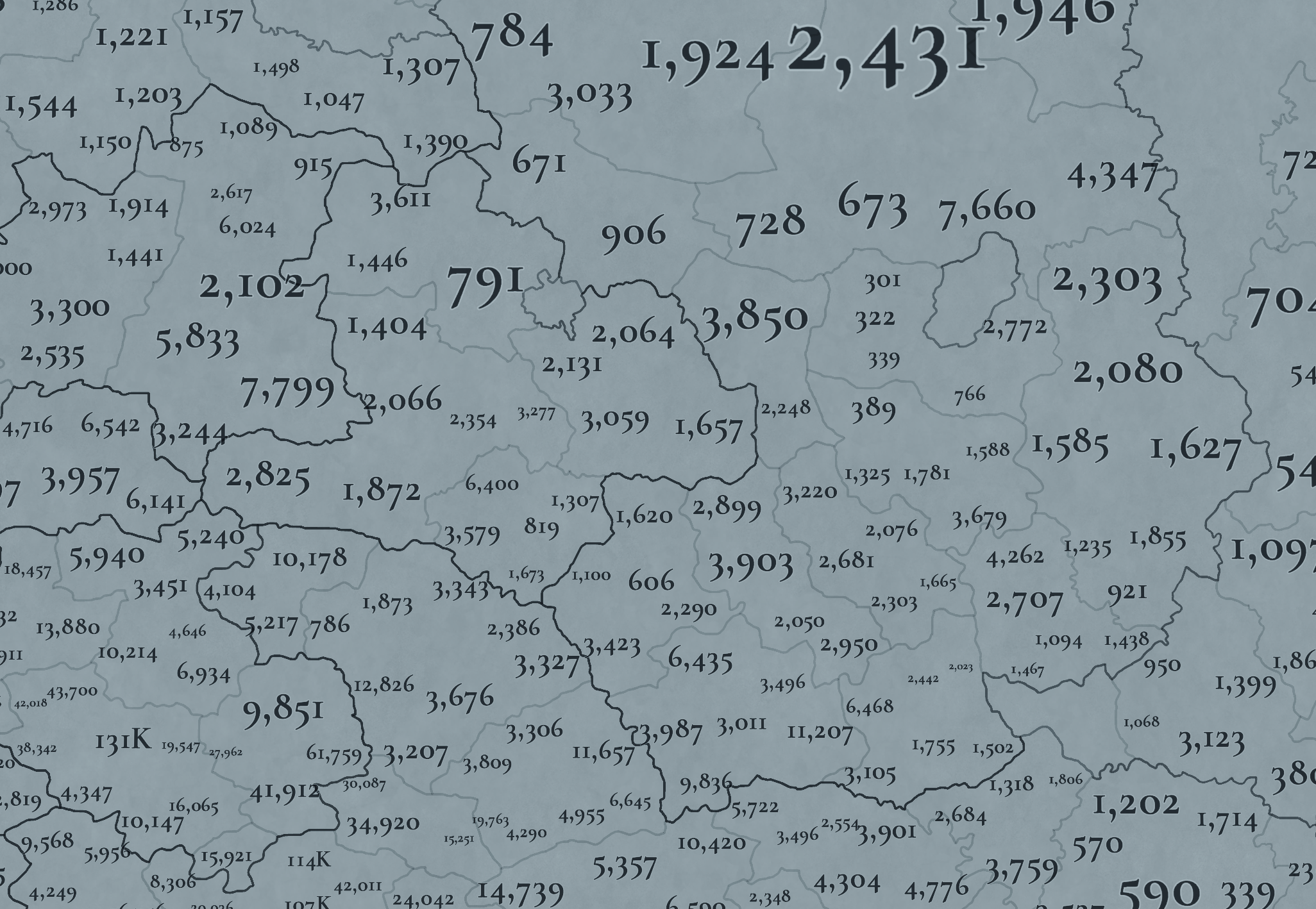
Country and Location population
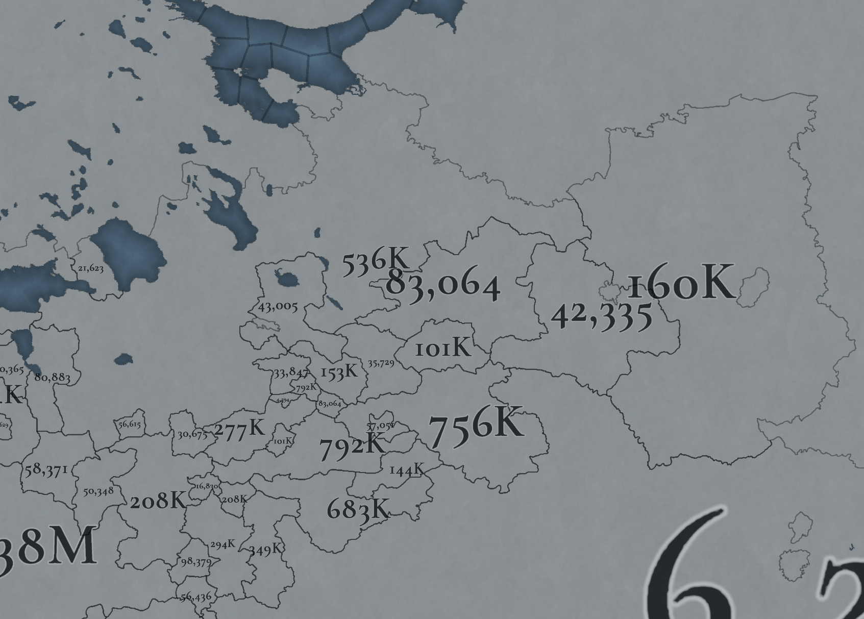
Country Population.png

Location Population SW.png

Location Population SE.png


Location Population NE.png

Location Population NW.png

Not many people inhabit the Russian core, approximately 6M in total. This poses a series of challenges regarding the expansion of any Russian country. Also, we've divided into 4 different maps of the location population of the region, to make it possible to visualize. A side note: you might note that the population of NW Novgorod and Karelia is calculated a bit differently. That's because Johan took care of drawing the Scandinavian map in an early stage of development, and the Content Design team took over the rest of Russia at a later stage when we had already refined a bit more our population calculation methods. This means that when we do the feedback pass after this Tinto Maps, in a few weeks, we'll homogenize the style, as well.

And this is all for today! We hope that you’ll find it interesting, and give us great feedback! Next week we’re traveling to Carpathia and the Balkans! See you!
 
  • 162Like
  • 67Love
  • 7
  • 6
  • 5
Reactions:
Will transport ships be a thing over big lakes like caspian sea or lake ladoga? I believe that would add more diverse way playing in areas around lakes. Like Native americans on canoes or colonial powers taking controll taking advantage of the huge river systems and large lakes that connect many parts in both south and north america.

Also combat in like lakes and rivers could be doable if there was like a magnifying glass when you hover over the river and boats and verry narrow combat width but I believe I've read or heard it somewhere that navigatible rivers will not be a thing but I think that is something I would like you to reconsider becouse it adds more fun being inland nation close to a river or perhaps even who controll the entrance of a river can toll the others or controll trade in some way.

Love this map with many provinces can't ever go wrong with that and cool little wasteland added in finland/russia looks like an interesting place to start:cool:
 
  • 3Like
Reactions:
Will transport ships be a thing over big lakes like caspian sea or lake ladoga? I believe that would add more diverse way playing in areas around lakes. Like Native americans on canoes or colonial powers taking controll taking advantage of the huge river systems and large lakes that connect many parts in both south and north america.

Also combat in like lakes and rivers could be doable if there was like a magnifying glass when you hover over the river and boats and verry narrow combat width but I believe I've read or heard it somewhere that navigatible rivers will not be a thing but I think that is something I would like you to reconsider becouse it adds more fun being inland nation close to a river or perhaps even who controll the entrance of a river can toll the others or controll trade in some way.

Love this map with many provinces can't ever go wrong with that and cool little wasteland added in finland/russia looks like an interesting place to start:cool:
idea i had to support it
 
  • 1Like
  • 1
Reactions:
Regarding the naming, not sure if this is a very good choice of it. We went through this on Wikipedia way too many times already. Muscovy is a latinized exonym, which in Russian both historically and today both in academia and colloquially deemed anti-scientific and almost derogatory. Proper English localizations for any East Slavic monarchical feudatory polity would be like Moscow -> Moscow (here as an adjective) Principality -> Grand Principality of Moscow. What to choose between Principality / Dutchy / Princedom etc personally I am not quite sure, but would go with Principality since it is both somewhat unique (in comparison with purely westernized term dutchy with another translation and meaning in Russian) and convenient, but ideally it should be the same with Lithuania.
Snowflakes' sensitivities are snowflakes' problems. Muscovy is the historically accurate and period-relevant exonym regarless of these crybabies. It also serves as a tool to distinguish between the city and the polity.
 
  • 11
  • 2
Reactions:
We usually take into account linguistics for cultural division. So, 'Novgorodian' portrays the 'Northern dialects' of Eastern Rus, 'Muscovite' the 'Central dialects', and 'Severian' the 'Southern dialects'. But take this as an open answer; I think that there might be reasons to unify the culture into 'Russian', and also to further subdivide it (as another person pointed out on the previous page); we'll review all the informed opinions on the matter after a while, and make a decision regarding that that feel appropriate both for historical and game-logical reasons. Thanks for the input, by the way. ;)
Hi Pavia!
I believe that dividing Russians into several distinct cultures lacks historical justification. However, if it is necessary to separate them for gameplay or balance reasons, please consider giving them more meaningful names.

1) Referring to Russian culture as Muscovite or Novgorodian makes no more sense than calling English culture Londoner or French culture Parisian.
2) Moscow was founded in 1147. The idea that it developed a unique Russian culture within 200 years and managed to spread it to neighboring principalities seems implausible to me, as Russian people had lived in these lands long before that.
The following names for Russian cultures would be more appropriate:
  • Northern Russian culture
  • Central Russian culture
  • Southern Russian culture
 
  • 7
  • 4Like
Reactions:
Why there are hills in Novgorod-Muscovy are a bit of a mystery to me.
Um, because there are hills in the area. There's at least Valday, Smolensk and Moscow uplands (hohenrucken). The ones up to 300m above sea level, yeah. That kind of hills.
I guess they appear as hills to locals because they are criss-crossed by eroded river valleys up to 100m deep. I presume you use the term "rolling hills" for this phenomenon.
 
  • 2Like
Reactions:
1) Referring to Russian culture as Muscovite or Novgorodian makes no more sense than calling English culture Londoner or French culture Parisian.
I second this argument by the following:
Numerous locations in Europe are named after old tribes, and the names survived to present day. Ulster, Burgundy, Saxony, Gotland, Galicia, you name it.
Conversely, locations in Gardariki are named after towns as depicted by Novgorod/Muscovy/Kiev. It works literally up to Donetsk/Lugansk Republics right now. The old slavic tribal names have been gone for ages - while some Ugric tribes & names do survive.
I would support the idea of North/South Russians, and then some colour-coded Ruthenians.
 
  • 2Like
  • 1
Reactions:
Um, because there are hills in the area. There's at least Valday, Smolensk and Moscow uplands (hohenrucken). The ones up to 300m above sea level, yeah. That kind of hills.
I guess they appear as hills to locals because they are criss-crossed by eroded river valleys up to 100m deep. I presume you use the term "rolling hills" for this phenomenon.
With that argument nearly every topographic feature needs to become a hill in game. I also want the hills in Flanders to make it ingame somehow, but unless rolling hills makes it into the game, I'm afraid designating this type of topography as hills does not make much sense. You'd equate the relative rise of 100 metres over several kilometers to the foothills of the Urals.

Even then, rolling hills will only occur in a few spots here and there, but that would give some granilarity to the region which would be much appreciated. But the placement of rolling hills should be in different spots than about half what Tinto presented in their v1
 
  • 4
Reactions:
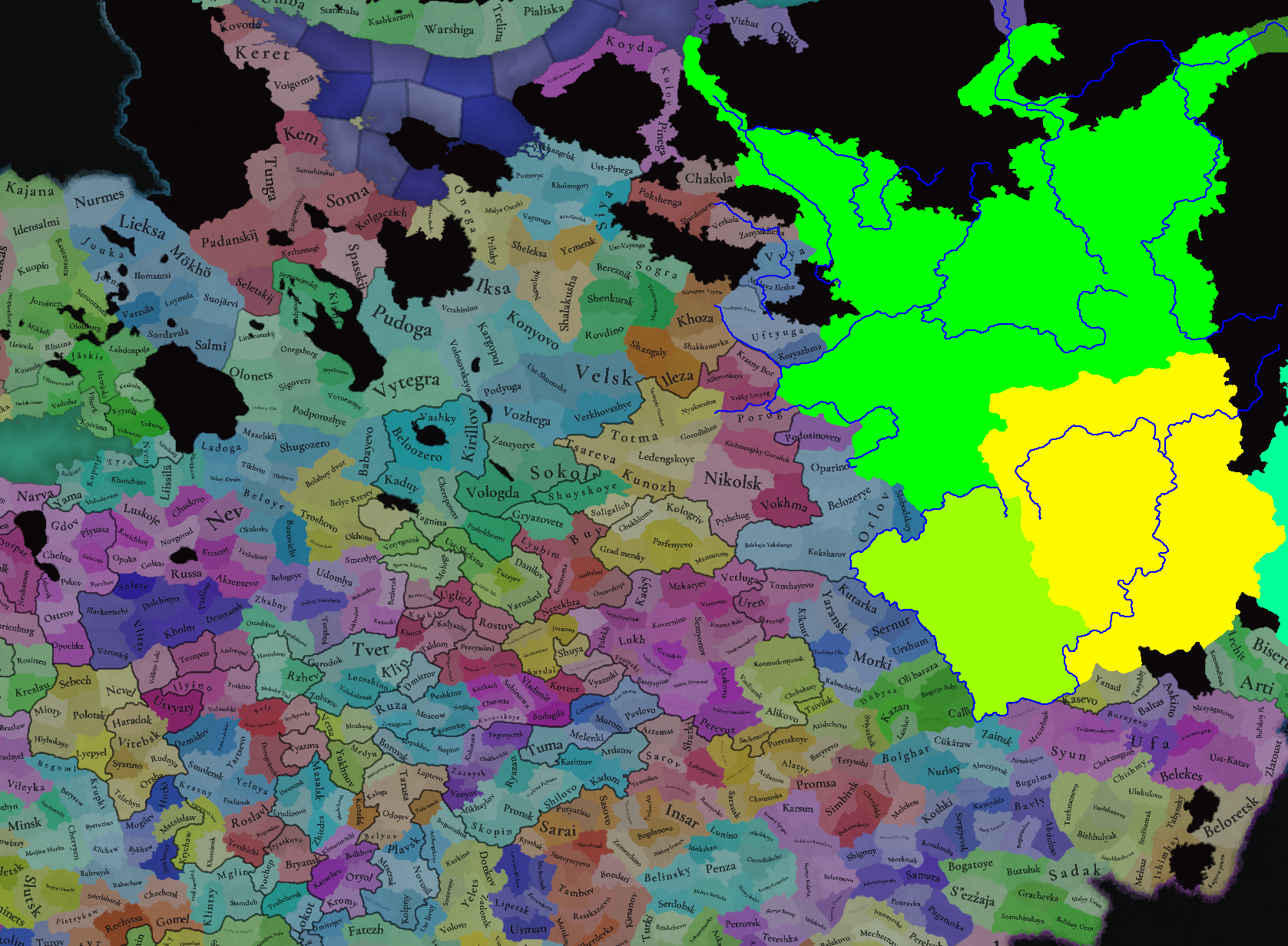
I think this is what a cultural map should have looked like in 1337.
The Komi Permyak and Zyryans cover too much land in the north and the east . In the Principality of Perm they do not exist at all, they are replaced by the Udmurts
I think that instead of the name of the Kazani culture, it is better to use the name Bolgars, later we can give an event that will change the culture in the region.
The Khanty and Mansi once lived on both sides of the Ural Mountains, but many of them were assimilated into the Komi People in later years.
The Mari people inhabit a small area, they lived as far as Nizhny Novgorod
The Bashkirs should inhabit the lands that have the Mari culture in the south.
Mordvins do not exist on the map at all. They should be pagans with some influence of Islam and Christianity.
As for Vyatka Land this region should be culturally mixed.
View attachment 1156216
The Bolgars shouldn't be present at game start as they all quickly integrated into Kazani Tatars, except for a sub-group of pagan Bolgars who became the Chuvash, who are only present in the western regions you showed on this map. Also Bashkirs never extended that far north, the region was majority Komi and Udmurts, also the Udmurts shouldn't have any southern pockets as they never had any populations to the south. Splitting Komi into Permyak and Zyrian is anachronistic, the divide only came about in the 18th century and Komi should stay a united culture in 1337. See my map for more details.
 
  • 1
Reactions:
The Bolgars shouldn't be present at game start as they all quickly integrated into Kazani Tatars, except for a sub-group of pagan Bolgars who became the Chuvash, who are only present in the western regions you showed on this map. Also Bashkirs never extended that far north, the region was majority Komi and Udmurts, also the Udmurts shouldn't have any southern pockets as they never had any populations to the south. Splitting Komi into Permyak and Zyrian is anachronistic, the divide only came about in the 18th century and Komi should stay a united culture in 1337. See my map for more details.

You contradict yourself when you write that the bolgar does not exist, when you write that they became Chuvash.
Bolgar perfectly represents Chuvash

The rise of the Kazan Tatars is associated with the arrival of Ulugh Muhammad and his people in Kazan at that time there were no Kazan Tatars.
As for the Komi people, I agree that one culture is enough. But paradox, if he wants, will divide them into two.


As for the Bashkirs, I have knowledge about their presence there from the user Omogoj.
Clip2Net Menu_2022-11-09_06_49_27.png


gHQ8jVJTlhU.jpg
 
Last edited:
  • 2
Reactions:
we're going east and east. we gonna be seeing east Asia within tinto maps 13
 
One I know for sure is incorrect. Borisoglebsk is the name of the city in Voronezh oblast. One you wanted to say is "Borisoglebskije Slobody"
That would be even more correct, right! I'm just not a huge fun of veeeery long location names...
I think you guys should strive to add more playable Northern Eurasian tags this time around. Basically one tribal tag for each culture, or more if they had states (the Mari, Mordvin, Komi and Udmurt had principalities, Tatars, Yakuts, Tuvans, Teleuts, Telengits and Khakas had khanates, Chukchi, Selkup some other groups resisted against Russians in an organized fashion). I CRAVE to play in the frozen north if possible. The same standard with Northern American tags basically, since the process here was very much similar down to foreign epidemics and colonization. Of course this is also a wish for the inclusion of Saami and Finnic tribes too, as well as Samoyeds of European Russia. A Finland releasable is far from enough, in terms of gameplay and immersion both.
Yeah... can't wait to see Vyatka-Vym wars, or Galich-Vychegda, or Pelym tribal alliance of fierce voguls... all with 300-man tribal levy armies... and Stroganoffs of course!
Frozen north can be quite lively and north-eurasian gameplay may include a looot of expeditions into wilderness.

Game start is just 50 years before christian mission to Small Perm (to the north of Great Perm, near Vym and Vychegda) had began with St. Stephan Permsky going from Ystyug to the east...
Система_уральских_княжеств_на_карте_Сибирского_ханства_16_век.jpg
 
  • 9Like
  • 1Love
  • 1
  • 1
Reactions:
That would be even more correct, right! I'm just not a huge fun of veeeery long location names...

Yeah... can't wait to see Vyatka-Vym wars, or Galich-Vychegda, or Pelym tribal alliance of fierce voguls... all with 300-man tribal levy armies... and Stroganoffs of course!
Frozen north can be quite lively and north-eurasian gameplay may include a looot of expeditions into wilderness.

Game start is just 50 years before christian mission to Small Perm (to the north of Great Perm, near Vym and Vychegda) had began with St. Stephan Permsky going from Ystyug to the east...
Система_уральских_княжеств_на_карте_Сибирского_ханства_16_век.jpg
There is one problem in these formations - a very small population.
there is literally nothing to eat there. only fish + whatever they catch in the forest.
no grains.

Much more interesting are the principalities of Southern Siberia close to the Turks - the Yenisei Kyrgyz, etc.
 
There is one problem in these formations - a very small population.
there is literally nothing to eat there. only fish + whatever they catch in the forest.
no grains
They should trade fur and produce some fish. Their best defence is only farness and difficulty(impossibility) of bringing enough troops by Moscow or Novgorod. (You leave the work to Stroganoffs and cossacks here.)

BUT also this is a partial answer to climate question. Vologda and Beloozero definitely shouldn't be arctic (I live there!), they are temperate, but they should be food-deficit regions (as Novgorod), so player won't be able to push too much people there and breed millions on free land, creating new Frances in every area by 1600-th. So that even with fur/gold or colonisation effort you won't be able to feed people over some bare minimum.
 
  • 3Like
Reactions:
With reference to late Victor Temushev (Ви́ктор Никола́евич Те́мушев (белор. Віктар Мікалаевіч Цемушаў, a fabulous cartographer, one of 2 Temushev brothers), I'm slightly worried about your modelling of internal (in-fill) colonization. I'll try to describe 2 examples.

1) There was no Smolensk highway. Napoleon (if he invaded 400 yrs early) wouldn't have gone to Moscow in a straight line. BUT Napoleon did get to Moscow in a straight line. Transport routes changed over centuries (over timeframe of a game).
1a) Temushev provides examples from chronicles of armies using the river systems to travel around. IIRC, it was the reason for continued importance of small princedoms of the Upper Oka river. Like, if you start in 1337, this should be the preferred route for a century, maybe even two.
2) As you probably know, there was (and still is) a lot of empty space in this region. With enough granularity, some map cells have to be "wasteland".
2a) Temushev considers the definition of borders in the surviving acts & treaties. Sometimes, a river border is nice & neat, but many sections were described as "forest" or "marsh".
2b) Consequently, Temushev referenced a complaint by some Vyazma peasants: Mozhaysk settlers have cut through the border forest and poured over into what Vyazmans considered their side. In terms of your map, it means that Vetza (the province between Vyazma and Mozhaysk) has been a no man's land for some time but colonized later.
for roads i think this game will have the road building thing from imperator so a road from smolensk to moscow can become a reality if needed . up until that point there was only few royal highways in europe anyway so the player and ai will have freedom to build road network they want
 
  • 1
  • 1Like
Reactions:
You contradict yourself when you write that the bolgar does not exist, when you write that they became Chuvash.
Bolgar perfectly represents Chuvash

The rise of the Kazan Tatars is associated with the arrival of Ulugh Muhammad and his people in Kazan at that time there were no Kazan Tatars.
As for the Komi people, I agree that one culture is enough. But paradox, if he wants, will divide them into two.


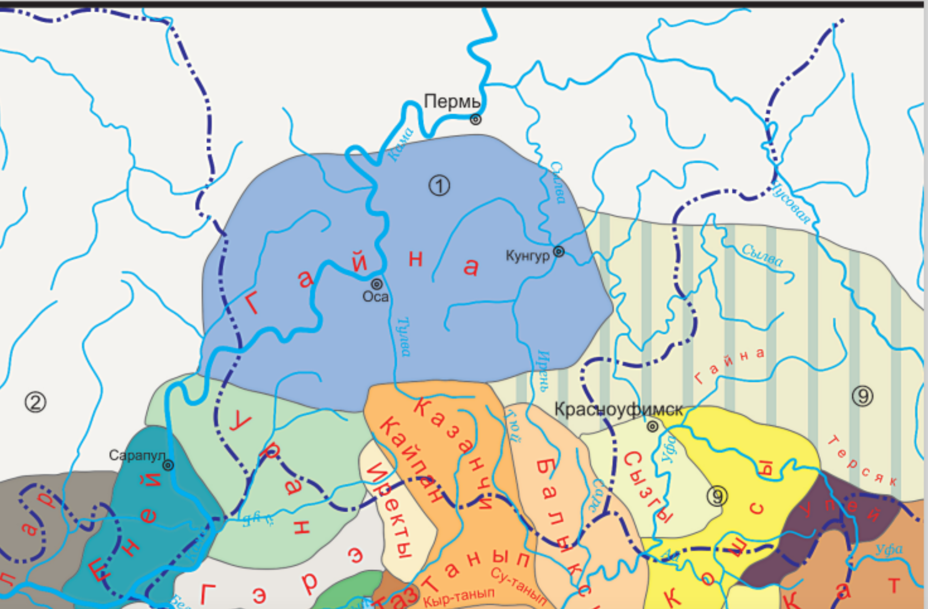
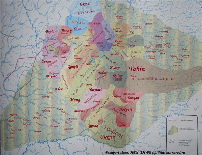
As for the Bashkirs, I have knowledge about their presence there from the user Omogoj.
View attachment 1156326

The northernmost Bashkir tribes seem to have come there later on, namely Gayna and Tanyr. In fact the migration was just taking place and there existed native Ugric and Permian tribes before them. Many of these tribes were also originally Ugric or Bulgar speaking and only Kipchakized later on.
 
You contradict yourself when you write that the bolgar does not exist, when you write that they became Chuvash.
Bolgar perfectly represents Chuvash
I'll clarify my statement on the Chuvash and their connection to the Bolgars, the Chuvash are not Bolgar. They were originally the same people as the Bolgars, however the group's split after the conversion of Volga Bulgaria to Islam in 922. With them becoming more and more distant for the next 313 years before Volga Bulgaria fell to the Mongols in 1236. Calling the Chuvash Bulgar is the same as calling Brazilians Portugese; the groups have been separate for so long that they can in no way be described as the same people anymore.

As for the remaining Bulgars, roughly 80% of all Bulgars were killed in the Mongol invasion, while the remaiming Bulgars merged with the Kipchaks to form Kazani Tatar culture. Some Bulgars did flee to Chuvashia after the Mongol conquest, but they made up a small minority of the population and quickly assimilated into Chuvash culture. But even then that was 100 years before the start date of PC, so there shouldn't be any Bulgars in game.

Wikipedia page on the topic

Also the Wikipedia page you cited says that the Gaina were Tatar, not Bashkir.
"As D. B. Ramazanova writes, the descendants of the Gaina-Tarkhan people, who inhabit modern western Bashkiria , speak the Tatar language , consider it their native language, and their language lacks the specific features of the Bashkir language [4] .

According to F. G. Khisamitdinova , the descendants of the Bashkirs of the Bulyar tribe, living in western and northern Bashkortostan and adjacent territories, are speakers of the northwestern dialect of the Bashkir language [5] , however, most researchers, including Bashkir ones, attribute the dialects of this dialect to the Kazan dialect of the Tatar language , [6] [7] [8] [9] and the absolute majority of the Turkic-speaking population of the territories where this dialect is spoken in censuses indicate their language as Tatar, and not Bashkir or one of its dialects."
 
  • 3Like
  • 1
Reactions:
Opole is a type of soil - fertile.
and the soil has not changed in the region since the 13th century.
So Opole is exactly the same as on the map above.
I have traveled around that region, Opole is clearly distinguished by its relief.
These fields and hills are beautiful. and around Opole there are swamps and mixed forests on poor soils.
Sorry, I probably did not make myself clear. Yes, Opole is where the fields are located, it is a sort of landscape with good and fertile soils where forests are not dense. But Opole you are probably talking about is Yurievo Opole, which is only one zone of Russian Opole. In reality, Opole is region AFTER fields, it is a borderline region of slavic expansion where fields end and forests start. Its distinct feature is being higher than surrounding landmass called Polesie, which became swamped forests, because of water drainage. It is charachteristic of many regions inside Russian plain, but it is generally attributed to borderline forest steppes region.
There are Kasimovo Opole, Meschovsk Opole, Novgorod-Severian Opole, Bryansk Opole, Trubchevsk Opole and so on.
 
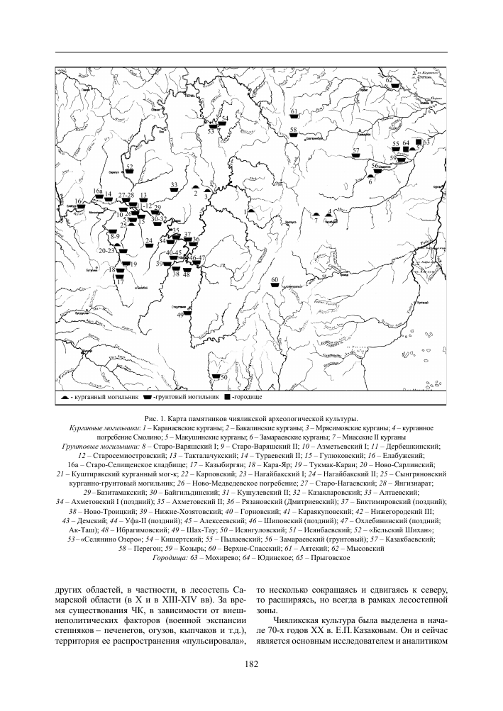
Seems like the Chiyalik culture existed also along the Sylva river in Perm krai. So perhaps they should inhabit a much larger area to the north. They seem to have been exposed to Islam but not been converted entirely in this area. However they weren't Bashkirized at this point since their ethnogenesis was still undergoing in Bashkiria itself.
В заключение мы попытаемся определить место, занимаемое Кишертским могильником в истории населения Прикамья и Приуралья. Нами было проведено сравнение ряда погребальных памятников региона: Кишертского, Селянино озеро, Кушу-левского, Дербешкинского, Такталачукского и Азъметьевского I могильников, объединенных наличием гребенчато-шнуровой керамики, по усовершенствованной методике, разработанной Е.П. Бу-натян, В.Ф. Генингом и В.А. Борзуновым [Генинг, Борзунов, 1975. С. 42-75; Бунатян, 1985. С. 25-54]. Наибольшую степень сходства по всем совокупностям признаков погребального обряда имеют могильники чияликского типа Дербешкинский, Такта-лачукский, Азъметьевский I и Кушулевский (поздняя часть). Также высокую степень сходства продемонстрировали Кишертский, Селянино озеро и Кушулевский (ранняя часть) могильники. Это позволяет сделать вывод, что последние, и в частности Кишертский, некрополи представляют ранний этап чияликской культуры, период ее сложения. Исходя из того, что носителей чияликской культуры определяют как угров [Казаков, 1978. С. 83-86], мы считаем, что исследуемый могильник также оставлен угорскими племенами.

Погребальный инвентарь свидетельствует о достаточно широких культурных связях населения, занимавшего Кунгурский лесостепной остров. Массовые находки ювелирных изделий булгарского типа говорят о тесных связях с Волжской Болгарией, которая являлась, вероятно, основным торговым партнером местных племен. Шумящие подвески указывают на определенные связи с родановцами, а пряжка приобского типа свидетельствует о контактах с зауральским населением. Правда, нам кажется более вероятным, что эти связи были не с нижнеобским населением, а с племенами юдинской культуры, где найдены аналогичные вещи и близкая керамика [Могильников, 1987. Табл. XXI, 27, 29, 31, 33; XXI, 41].

Ряд черт погребального обряда, таких как западная ориентация, положение умерших лицом к югу или северу, позволяют говорить о том, что население, оставившее Кишертский могильник, было уже знакомо с исламом. Вместе с тем основная масса черт в обрядности указывает на языческий характер памятника. Нам кажется возможным, что группа населения, проникшая на Среднюю Сылву и вступившая в тесные связи с волжскими булгарами, познакомилась от них и с мусульманской религией, причем знакомство пошло далее и, скорее всего, не все приняли ислам сразу и безоговорочно. Наличие явно «антимусульманских» признаков (положение умершего лицом к северу) свидетельствует об определенной идеологической борьбе среди сылвинского населения [Яблонский, 1978]. Вместе с тем следует констатировать факт проникновения ислама на Сылву, а Кишертский могильник, с определенными оговорками, относить к кругу раннемусульманских памятников [Гарустович, 1986. С. 78].
Machine translated
In conclusion, we will try to determine the place occupied by the Kishert burial ground in the history of the population of the Kama region and the Urals. We compared a number of funerary monuments of the region: Kishert, Selyanino Lake, Kushu-lev, Derbeshkin, Taktalachuk and Azmetyev I burial grounds, united by the presence of comb-cord ceramics, according to an improved technique developed by E.P. Bu-natyan, V.F. Gening and V.A. Borzunov [Gening, Borzunov, 1975. pp. 42-75; Bunatyan, 1985. pp. 25-54]. The greatest degree of similarity in all sets of signs of the funeral rite are the burial grounds of the Chiyalik type Derbeshkinsky, Takta-Lachuksky, Azmetyevsky I and Kushulevsky (late part). Kishertsky, Selyanino Lake and Kushulevsky (early part) burial grounds also demonstrated a high degree of similarity. This allows us to conclude that the latter, and in particular the Kishert necropolis, represent the early stage of the Chiyalik culture, the period of its formation. Based on the fact that the speakers of the Chiyalik culture are defined as Ugrians [Kazakov, 1978. p. 83-86], we believe that the burial ground under study was also left behind by the Ugric tribes.

The burial inventory testifies to the fairly broad cultural ties of the population that occupied the Kungur forest-steppe island. The massive finds of jewelry of the Bulgarian type indicate close ties with Volga Bulgaria, which was probably the main trading partner of the local tribes. Noisy pendants indicate certain connections with the Rodanovites, and a Priobsky-type buckle indicates contacts with the Trans-Ural population. However, it seems more likely to us that these connections were not with the Nizhneob population, but with the tribes of the Yudin culture, where similar things and similar ceramics were found [Mogilnikov, 1987. Tables XXI, 27, 29, 31, 33; XXI, 41].

A number of features of the funeral rite, such as the Western orientation, the position of the deceased facing south or north, suggest that the population who left the Kishert burial ground was already familiar with Islam. At the same time, the bulk of the features in the ritual indicates the pagan character of the monument. It seems to us possible that a group of the population that penetrated into Central Lithuania and entered into close ties with the Volga Bulgars also got acquainted with the Muslim religion from them, and the acquaintance went further and, most likely, not all accepted Islam immediately and unconditionally. The presence of clearly "anti-Muslim" signs (the position of the deceased facing north) indicates a certain ideological struggle among the Sylvan population [Yablonsky, 1978]. At the same time, it is necessary to state the fact of the penetration of Islam into Lithuania, and the Kishert burial ground, with certain reservations, should be attributed to the circle of early Muslim monuments [Garustovich, 1986. p. 78].

1719759857805.png

 
Last edited:
  • 8Like
  • 1
Reactions:
I'm worried about the population. This is a very huge number. The population in the 14th-15th centuries within the borders of the modern Moscow region ranged from 30 to 50 thousand. If we look at the game map, there are about 1,300 thousand people within these boundaries. Exceeds 26 times!!!
It seems very obvious to me they're afraid the Black Death is going to be very devastating and as such they're highballing the numbers so players can tank the hit better. In Spain it was the same thing, the numbers they showed were nearly double some of the more conservative estimates.