• We have updated our Community Code of Conduct. Please read through the new rules for the forum that are an integral part of Paradox Interactive’s User Agreement.

Tinto Maps #9 - 5th of July 2024 - Carpathia and the Balkans

Greetings, and welcome to another Tinto Maps! This week we will be taking a look at Carpathia and the Balkans! It will most likely be an interesting region to take a look at, with a lot of passion involved… So I’ll just make an initial friendly reminder to keep a civil discussion, as in the latest Tinto Maps, as that’s the easiest way for us to read and gather your feedback, and improve the region in a future iteration. And now, let’s start with the maps!

Countries:
Countries.png

Carpathia and the Balkans start in a very interesting situation. The Kingdom of Hungary probably stands as the most powerful country in 1337, but that only happened after the recovery of the royal power enforced by Charles I Robert of the House of Anjou, who reined in the powerful Hungarian nobility. To the south, the power that is on the rise is the Kingdom of Serbia, ruled by Stefan Uroš IV Dušan, who has set his eyes on his neighbors to expand his power. The Byzantine Empire, meanwhile, is in a difficult position, as internal struggles ended in Andronikos III being crowned sole emperor, at the cost of dividing the realm; both Serbia and Bulgaria have in the past pressed over the bordering lands, while the Ottomans have very recently conquered Nicomedia. The control over the Southern Balkans is also very fractioned, with a branch of the Anjou ruling over Albania, the Despotate of Epirus under the nominal rule of Byzantium as a vassal, Athens, Neopatria and Salona as vassals of the Aragonese Kings of Sicily, Anjou protectorates over Achaia and Naxos, and only nominal Byzantine control over Southern Morea. It’s also noticeable the presence of the Republics of Venice and Genoa, which control several outposts over the Adriatic and Aegean Seas. A final note: in previous maps, Moldavia was shown in the map, but we’ve removed it from it, and it will most likely spawn through a chain of events in the 1340s.

Dynasties:
Dynasties.png

The House of Anjou rules over Naples, Hungary, Albania, Achaia, and Cephalonia; they’re truly invested in their push for supremacy over the region. Apart from that, each country is ruled by different dynasties, except for Athens and Neopatria, ruled by the House of Aragón-Barcelona.

Locations:
Locations 1.png

Locations 2.png

Locations 3.png

Locations 4.png
This week we’re posting the general map of the region, along with some more detailed maps, that can be seen if you click on the spoiler button. A starting comment is that the location density of Hungary is noticeably not very high; the reason is that it was one of the first European maps that we made, and we based it upon the historical counties. Therefore, I’m already saying in advance that this will be an area that we want to give more density when we do the review of the region; any help regarding that is welcome. Apart from that, you may notice on the more detailed maps that Crete appears in one, while not being present in the previous one; because of the zooming, the island will appear next week along with Cyprus, but I wanted to make an early sneak peek of the locations, given that is possible with this closer zoom level. Apart from that, I’m also saying in advance that we will make an important review of the Aegean Islands, so do not take them as a reference for anything, please.

Provinces:
Provinces.png

Provinces! Nothing outstanding to be commented on here; as usual, we’re open to any feedback regarding them.

Terrain:
Climate.png

Topography.png

Vegetation.png

Terrain! The climate of the region is mostly divided between Continental and Mediterranean, with some warmer and some colder regions. Regarding the topography, the Carpathian mountains are famously important and strategic, while the Balkans are a quite hilly and mountainous region, which is also greatly covered by woods and forests.

Cultures:
Cultures.png

Here comes the fun part of the DD: The cultural division of the Balkans! A few comments:
  1. Hungary is full of different minorities. Transylvania, especially, is an interesting place: there we have a mix of ‘Hungarians’, ‘Transylvanians’ (which are the Romanian-speaking inhabitants of the region), ‘Transylvanian Germans’, and ‘Szekely’ people.
  2. We have divided the Southern Slavic-speaking region into their dialectal families of Slovene, Croatian, Bosnian, and Serbian.
  3. The Southern Balkans are mostly divided among Bulgarian, Albanian, and Greek cultures.
  4. We’re also portraying plenty of other cultures, such as Dalmatians, Aromanians, Sclavenes, Arvanites, Cumans, Jasz, or Ashkenazi and Romanyoti Jews.

Religions:
Religion.png

This one is also interesting. Apart from the divide between Western Catholicism and Eastern Orthodoxy, we have the Krstjani in Bosnia, Bogomils (the pink stripes both in Bosnia and Macedonia), and Paulicians in Thrace. The Jewish populations do not pass the threshold percentage to appear on the map, but there are plenty of communities across the region.

Raw Materials:
Raw Materials.png

The materials of the region. Something very noticeable is the richness of minerals, with plenty of Iron, Copper, Tin, Lead, Gold, and Silver. Specifically, Slovakia is very rich, and you definitely want more settlers to migrate to the region, and exploit its resources. The region is also very rich in agricultural resources, as you can see.

Markets:
Markets.png

The region is mostly divided among four markets: Venice, Pest, Ragusa and Constantinople.

Country and Location population:
Population 1.png

Population 2.png

Population 3.png

Population 4.png
Country and location population (which I’ve also sub-divided, and is under the Spoiler button).

And that’s all of today! I hope that you find the region interesting; we certainly think that it is. Next week we will go further south, and we will take a look at the Syrian Levant and Egypt. Cheers!
 
  • 193Like
  • 69Love
  • 7
  • 4
  • 3
  • 1Haha
Reactions:
Will it be possible to play as Moldova / Dobruja / any spawning tag (i.e. the Chinese) without starting as their overlord in 1337 and being tempted to sabotage them?
 
  • 1Like
Reactions:
Višesav is an incredibly obscure name to use for the location. The only source I could find that cites this name is:
I thought Višesav was basically the name for Kladovo? One of the two pre-Ottoman (Fetislam) ones, the other being the far more generic Novigrad

But yes, separating Negotin and Krajina from Kladovo/Ključ would be good
 
  • 3
Reactions:
There was already a strong Bosnian identity in the Late Middle Ages, with a Banate that became a Kingdom, a Church, and a dialect of their own.
The Ban of Bosnia took the title of "King of Serbia", that's why Serbia was a Knezevina, and later a Despotate, because the Kingdom title was held by the Kotromanic dynasty. And the Kosaca dynasty of Hercegovina, who were orthodox, always said they were Serbs, not Bosnians, showing the the culture we see as "Bosnian" was nothing more than a different religion. But, if you want to represent them, sure, BUT also add the Shops, since their regional dialect is a mix of (old)Serbian and Bulgarian, or add Macedonian, also a mix of (old)Serbian and Bulgarian, to represent the melting of cultures. People forget, that before Vuk Karadzic, Serbian language was closer to Bulgarian. Remember, some cultures managed to grow only under the Ottomans, not before them.
 
Last edited:
  • 4Like
  • 1
Reactions:
Hi

I tried to zoom but I just cant see for sure what is the raw good produced in Ragusa (Dubrovnik).

By the color I think its wool.

In my opinion it should be definetly SALT.

The republic actualy built more, higher and ticker walls (walls of Ston https://en.m.wikipedia.org/wiki/Walls_of_Ston ) for the defense of the saltworks than it did for the city of Dubrovnik.


Quick simple read:


Ty, cheers
 
  • 9Like
Reactions:
in the 12th century, under the Komnenos, the population of the Byzantine Empire reached 10-12 million people, mostly in Europe.
The Asian part of the empire was less populated.
Therefore, it seems that the population of the Balkans should be larger.

The Turks had not yet ravaged the cities of Thrace and Macedonia. and there was no plague yet.
 
  • 1Like
Reactions:
That is true, but the identity also primarily spread through the expansion of the Bosnian Banate/Kingdom. The parts of modern Bosnia that are under Serbian/Croat/Hungarian rule should have little to no Bosnian identity yet.

Hum, which was conquered mere years before the start, also had a regional identity of its own that wasn't really subsumed into Bosnian until well into Ottoman rule - and Hercegovina still has a distinct regional identity and dialects today. If anything, I would argue that Hum/Zachlumia, Travunia, Dioclea/Montenegro and the southern parts of Dalmatia (the Narentine lands) should form their own culture- "Primorci" or sth, as Hercegovinian and Montenegrin eventually emerged from it. The culture is largely a subset of Serbian, but it had a distinct identity and dielect, was exposed fsr more to Italy and the West, and Serbian and Bosnian Kings always included "King of the Littoral" as a separate title


Similar arguments can be made to represent Macedonian Slavs and or Torlaks/Shopes, as distinct from both Serbs and Bulgarians, given how fluid the distinction there can be
View attachment 1158730

EDIT: Speaking of, the Bosnian Church and Bogomils HEAVILY persecuted in both Hungary and in Nemanjić Serbia, they should be non-existent in Hungary and only have a small presence in Serbia (where they originally moved to Bosnia from, as a consequence of Stefan Nemanja's inquisition) Similarly, Hum, recently conquered from Serbia, should be overwhelmingly Orthodox still. Also, the Bosnian church was already in decline starting in the early 14th century- there should be a lot of Catholic pops in all of Bosnia, and Orthodox ones close to the Drina
Claiming the culture of Hum and Southern Dalmatia is a subset of Serbian is a stretch, to put it mildly.
If they decide to go to such a degree of granularity to add Hum culture as it's own, I wouldn't object, but, in that case, they should probably add dozens more across the game, and I'm not sure they want to go that far.
Being orthodox in the region, especially at the time, didn't meant automatically being Serbian, and vice versa.
 
I'm a little bit skeptical about having the Krstjani instead of splitting Bosnia up into Catholic, Orthodox, and Bogomil. But my knowledge about the specifics of Medieval Bosnia is nowhere near enough to be decisive on this matter. Can anyone recommend me some good books on the subject?
 
  • 1Like
Reactions:
So exciting and I think well done for granularity in Serbia. Couple of localisation suggestions I can offer as Serbian speaker:

- Peč should be Peć
- Pristina should be Priština

Budua/ Budva isn’t in the right place, should be further up the coast line and the Montenegrin coastal locations be split into Kotor, Budua, and Antibari (Bar).
 
  • 1Like
Reactions:
To be honest, we aren't completely happy with the concept either, as we have four different cultures for the 'Germans of the East': Baltic German, Silesian German, Carpathian German, and Transylvanian German. But we think that it's the 'less bad' solution to portray the cultural melting pot that these places were for the different German settlers.
They were called the Transylvanian Saxons, it might be better than just saying Germans. See here.
 
Thanks for correcting province names in Ruthenia. But still Halychyna covering only 20% of Halychyna is weird. Three suggestions on this map!
Balkans
1720203909034.jpeg

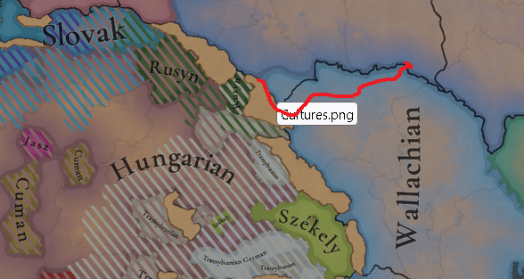
1. Again, to remove Rusyn culture. Eastern Slavs who lived on both sides of the Carpathians. since the tribe of White Croatians remained unchanged in the Project Ceaser timeline. Lands of Transcaphatia was ruled by the Galicia-Vohlynia kingdom from 1280-1320, pretty recently to the game timeline. The region is mountainous, so Hungarian elites contributed a little to the change in ethnic composure of the region. The first possible real divide happened in 1596 with the Brest Union that created the Greek-Catholic church. virtually separating orthodox Transcarpathian Ruthenians from other orthodox that remained in central Ukraine. Even then. nothing disastrous happened, the region remained in connection with Galicia (Halychyna/Red Ruthenia) and Bukovyna (Nothern) during Austria-Hungary in XVIII-XIX, and national rebirth in western Ukraine started here.
Rusyn is an endonym of Ruthenians while Ruthenian is an exonym.

So if the whole culture of Ukraine/Belarus is Ruthenian then Transcarpathia should be also Ruthenian. not Rusyn.

If you want to split Ruthenian into more cultures (I saw good examples. like white Ruthenians, Ruthenians, and red Ruthenians) then it should be red Ruthenian culture, at least like culture in Galicia. In case of more balkanizing (sorry) of Ruthenian culture, I advise making it a separate group to Muscovy/Novgorod.

2. Pokuttia/Bukovyna
Why this lands are portrayed as Wallachian(Romanian better?)? I can't find any sources to prove it being Romanian(Mostly or Major), only settled by Slavs, and Being part of Galicia-Vohlynia (Bukovyna to a lesser part)
Pokuttia, also known as Pokuttya or Pokutia, (Ukrainian: Покуття; Polish: Pokucie; Romanian: Pocuția) is an historical area of East-Central Europe, situated between the Dniester and Cheremosh rivers and Carpathian Mountains, in the southwestern part of modern Ukraine. Although the historic heart of the area was Kolomyia, the name itself is derived from the town of Kuty that literally means 'round the corner' ("Kut" by itself means "corner").
Bukovyna, or in this case Northern Bukovyna (Name appearing in XV century) was called at this time Shypyntsi land (Derivering from the village )
Of course, my bordering (except obvious Pokutiia) is hypothetical because we do know not so much but that was lands as part of Moldova that bordered Galicia-Volhynia and later Poland
1720206909614.png


3. SALT
MUCH MORE (In the Carphatians instead of Lumber)

Salt was one of the biggest blessings and curses of Galicia-Volhynia. Because of massive Salt mines Galicia was powerful and had a lot of money. But also much weaker due to the boyars becoming much stronger, to the extent of literally creating an oligarchy, they kicked out the princes. made new ones their puppets and they were one of the main reasons of Galicia fell to Poland. All because of SALT
 
Last edited:
  • 6Like
Reactions:
  • 3Like
Reactions:
Hi

I tried to zoom but I just cant see for sure what is the raw good produced in Ragusa (Dubrovnik).

By the color I think its wool.

In my opinion it should be definetly SALT.

The republic actualy built more, higher and ticker walls (walls of Ston https://en.m.wikipedia.org/wiki/Walls_of_Ston ) for the defense of the saltworks than it did for the city of Dubrovnik.


Quick simple read:


Ty, cheers
AGREE
 
Greetings and thank you for posting these maps! I have made similar feedback during the initial reveal dev diary because it showed a bit of the region and there was an issue there in my mind, but since you've talked how you want feedback on the specific map dev diaries, here it is! Since you have also mentioned that you will revise the Hungarian setup because it was one of the first maps created, I hope you will take a look here and add locations like the ones I suggest or similar! Additionally, any papers and quotes I give from them will be translations by me. Any sources I use will either be sources I found for my arguments (usually if they're not directly related to Sinj) or sources I used for my own university work with seminar papers. If you would like more sources and papers on this topic, I will provide them to the best of my ability, though so as not to be repetitive I will use one source per example. :D

I am coming from the perspective of a Croatian (trained in historiography as well as linguistics, it's what I have a Masters in, although I also do not want to make it seem like I am some sort of a huge expert generally - that said, I do have *some* authority specifically about the history of Sinj, which will be important here) so I do hope this is not taken from some sort of nationalist lens because I do not care for that. I will not comment too much on the cultures, for example, because I am mostly fine with them, except for Bosnian pops having majorities in Bihać and Makarska provinces (in the size and look that they have now) and a minority in Metković. Makarska and Metković were *very* recent acquisitions by the Ban of Bosnia Stjepan II. Kotromanović (and while they did last for some time, they did not last for *that* long). They should probably be mostly Croatian pops instead in those locations (generally, the less urban the area was in the early/high medieval ages, the more Slavic population it had, which for this area of what is considered Dalmatia generally means Croatian) at this starting date.

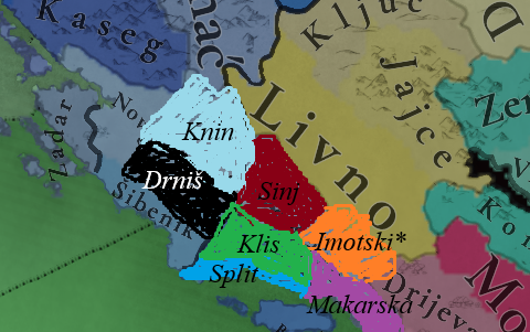
1720199953215.png


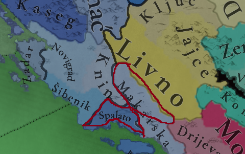
The main, glaring issue that I have with the Dalmatia part of the map are the locations of Makarska and Split (or Spalato, since it is owned by Venice). While Makarska was a town that became at least somewhat important in the early part of the game, its influence did not and would have not been able to go inland past the Biokovo mountain range (its highest point is called St. Jure (St. George) at 1762 m - arguably you could make it an impassable terrain between Makarska and the location of Imotski that I will propose because it *was* almost(though not entirely) impassable, and only in 2013 was a tunnel between Imotski and Makarska that goes through Biokovo finished, shortening the trip by a huge amount). That made it completely focused on what is today called the Makarska Primorje/Rivijera (and why it was coveted by Venice). As such, the northeastern portion of the location as it is now(circled in the image above) simply was never in its control. "The general and judicial history of Makarska and its coastline up until the rule of Austria", 2017, by Bartul Marušić (original title in Croatian: "Opća i pravna povijest Makarske i Primorja do austrijske vladavine") gives an overview of the history of Makarska in a succint yet informative enough manner for this post.

The other issue concerns almost the entirety of the province of Spalato. Simply put, Venice (and the Dalmatian cities themselves) had almost no interest in laying claim to the inland area of Dalmatia. Venice's interest in particular is in the coastline specifically due to the specific geographic, weather and maritime circumstances. Firstly, the sea currents in the East Adriatic go south -> north, or in other words, from the rest of the Mediterranean towards Venice, while the West Adriatic currents go from Venice towards the rest of the Adriatic. That made it important to have the ships laden with goods to come towards Venice on the East Adriatic side of the sea as it was simply easier for ships to do so. However, the Adriatic is a pretty stormy and windy sea, similarly to (IIRC) the Tyrenean sea. Specifically, there is a wind called "bura" which is a strong and cold northeastern wind. These two conditions, the sea currents and the weather, made it a priority to have land at which ships can easily moor in case of bad weather events. Just by looking at the geography of the East Adriatic coastline it is pretty clear that, as one of the regions with the most amount of islands, peninsulas and such. Venice's priority would be control of the islands and the coastline as it based its wealth on trade.

The reason I mention all of this is because the province of Spalato in game has far more territory than it should have. Split didn't even control Klis, the very slightly inland fort nestled on a high hill between two mountain ranges, Kozjak (to the north/northwest) and Mosor (north/northeast) of Split. It was only in the 17th century that Venice actually attempted holding Klis and have that fort given to them in a peace treaty (Mario Marasović, Battles for Klis in the 16th and 17th centuries (Borbe za Klis u 16. i 17. stoljeću), 2016). That makes the current setup of locations very, very awkward to say the least. However, there are some solutions, though unfortunately none are ideal for reasons I will outline later.

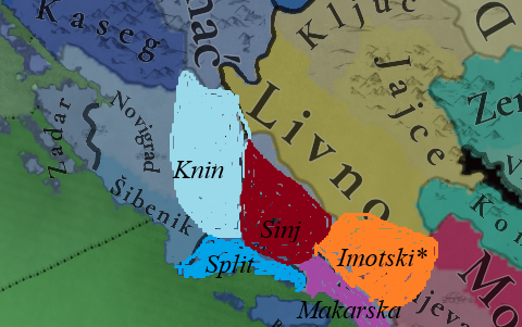
Solution 1:

Solution.png


This is the initial solution I came up with so as not to fragment this location potentially to too much of an extreme. The biggest changes are the additions of Sinj and Imotski as locations, pushing Makarska towards its historical reach of incluence, and extending Knin both mildly west and south. Sinj is the main town of what has been known and is still today known as Cetinska krajina (the Cetina region), and its territory goes up northwest until Vrlika, south towards Dicmo, southeast towards Trilj (and a bit beyond), and northeast up to Kamešnica, part of the Dinarid mountain range. In some ways, the town/fort existed since the time of the Illyrians, and in Late Antiquity/Early Medieval times it is called "Castellum Asinio" (Original source is Constantine Porfirogenet's De Administrando Imperio, and although that source has its issues, it is still likely that Asinio existed at that time). Technically, the town disappears for several centuries from historical records, though the most likely theory is that it was simply called "Cetina/Cetingrad". There are several reasons for that - firstly, the duke Domald and his family controlled the area of Cetinska krajina from their seat in Cetina/Cetingrad(Ante Milošević, Archeological remains of upper and middle Cetina river, 1981 (Arheološki spomenici gornjeg i srednjeg toka rijeke Cetine)).

Secondly, after Ludovik I. of Anjou dealt with the Hungarian and Slavonian nobility, his next agenda was to deal with the Croatian noble house of Nelipići, rules of the town of Knin and its region (including some parts on the left side of the Krka river, not just the nearer right side). They were finally defeated in the 1340.'s and in royal documents they were given the castrum regale Zyn (Sinj had around 40 or so name spellings in official documents in its history) and its surrounding territories (generally considered to be roughly what we now call Cetinska krajina). The original draft of the document mentions castra Cetina. Essentially, Ludovik I. gave the Nelipići alternate territories in exchange for being loyal vassals, which they were until they died out. Source: Krešimir Kužić, History of inland Dalmatia, 1997 (Povijest Dalmatinske zagore). I can offer more if necessary.

The problem with this solution is that it does not follow the official borders of the time in which the Bosnian king Stjepan II. Kotromanović established rule between Cetina and Neretva down towards the Adriatic coastline. However, whether he actually controlled said territory can be called tenuous as it was far from his powerbase, and only his successor, Tvrtko I., was able to be said to have actually controlled not just up to Cetina, but most of Dalmatia. Essentially, the more realistic borders would look something as I present them there (with the location of Sinj going up to the Dinarid mountain range). However, I also admit the location is perhaps too big, and same goes for Knin. The problem lies in the fact that the areas between Split and Sinj as well as Šibenik and Knin (and inland Novigrad as it is here) were sparsely populated, with very hilly terrain and some plateaus for small villages. However, this would probably be a good compromise between gameplay and history as it would not fragment the region too much.

Imotski, as an aside, was the fort that controlled the region between Biokovo and the Dinarids, however, if anyone else has a suggestion for a better town to represent the location (and perhaps maybe make the location of Livno a bit smaller as it is rather big), I think it'd be a worthwhile discussion to have as I cannot claim to know for certain what should be there.

Should you wish to make the setup more historical (for the most part), it would perhaps look something like this:

Solution_2.png


This setup reflects a much more logical and strategic level of influence of locations and towns they're named after, for the most part. Klis did not actually have that much influence northwards because it is actually more nestled towards Split rather than outright in between the two mountain ranges, Mosor and Kozjak, but Sinj's influence also realistically doesn't reach towards those same mountain ranges (aside from the rule of Ivaniš Nelipić from 1378. - 1435., who united the entirety of "middle Dalmatia" under his rule, including Split and Omiš, but up to (not including) Šibenik). Drniš is also ahistorical for the start of the game because the earliest mentions of the town's existence is 1494., though it only really came to prominence during Ottoman rule decades later. However, there is no other notable town in the area (besides Knin) and it neatly pushes Šibenik's borders more back to the coastline (in fact, I should've added more territory to Drniš in direction of Šibenik). Drniš did become an important Ottoman garrison, though, and since there have been examples of towns that did not exist in 1337, but are influential/logical enough to have in the setup, Drniš seems like a logical addition to me.

That said, this secondary setup would fragment this region perhaps far too much. I would much prefer the more fragmented setup, but I will also understand if it doesn't happen. Before I forget, Sinj should be flatlands with production of grain(while it is hilly, there is a large field of farmlands called 'Sinjsko polje' near and around the Cetina river under the control of Sinj). You could make it a plateau too, but it is not that high up compared to sea level. Drniš would definitely consist of hills, Klis would consist of mountains, and Imotski also either flatlands or plateau.

Additional general suggestions: While I don't think it needs to be a situation or anything, an event chain related to the Nelipić rebellion and the changes in territory is something I would love to give more details for if you'd consider making it.

In my mind, there should be a Situation in case Hungary has no eligible ruler of any of its three historical dynasties (Arpad, Anjou, Jagiellon), have low crown power, and have the HRE Emperor (if the HRE Emperor borders Hungary, in particular Austria) and a strong Balkan Power (historically Ottomans, but could also be Byzantium, Serbia, or whoever else gains dominance) for its conditions. It would spawn all of its regional vassals which could decide whether to align with the HRE Emperor or the Balkan Power, creating a huge civil war situation. That was the setup through which the Habsburgs became rulers of Hungary and Croatia in 1527 (though for a long time they only owned only the westernmost parts of both) and had a civil war with Janos Zapolny, the Prince of Transylvania, who became an Ottoman vassal. This historical occurrence is also a good reason for the existence of Slavonia as a PU duchy (the full official title of the Kingdom of Croatia was the Kingdom of Croatia, Slavonia and Dalmatia), but if it can spawn through an event, that is also a good idea. Specifically, Croatian nobility voted to support the Habsburgs, but the Slavonian nobility voted to support Zapolny, hence my reasoning for Slavonia's existence.

I would also add the condition that, should it be the Ottomans that become the Balkan Power in this Situation, that when the Situation occurs, Croatia is given the entire province of Zagreb and Varaždin (you could rename the province to Zagorje or Hrvatsko Zagorje, though that is also not necessarily the best solution as it technically doesn't include Zagreb) as well as the locations of Koprivnica and Bjelovar, seeing as the understanding of where the Kingdom of Croatia specifically changed northward historically due to the Ottoman invasions, while Kingdom of Slavonia's territory changed to what is today considered the region of Slavonia. This is something that is hard to give a source for, but it is evident in Zagreb becoming Croatia's most important city past 1527. instead of towns/cities in Croatia's original heartland in Lika and inner Dalmatia.
(What I described here would cover the historical events regarding the Croatian part of the Situation, but I cannot give any specific suggestions for the rest of Hungary at the time)

That would be it. This was a really long post. Thank you very much to the devs and all other posters that read this. I hope you learnt something new, and if there are any suggestions to be made on top of mine (or criticism), please give them. :D
 
  • 10
  • 5Like
  • 5
Reactions:
I think it's absurd that the Bosnian variant of Christian is just called... Christian. The wikipedia article for the Bosnian church says that they usually just called themselves Christians. Sure. So did all other Christians. I think calling the religion "Bosnian" is obviously preferable.
 
  • 5
Reactions:
First thing: in Transylvania the number of Romanians(not Transylvanians, as there was essentially no difference between Romanian speaking people in Transylvania and outside of it, also, they were orthodox)was around the same with Hungarians and Germans combined, so showing a Hungarian majority anywhere is wrong.
Second thing: I saw in Wallachia a location called Ploesti, even though it should be Ploiești.
Third thing: the western parts of the Carpathians should be extending a little more to the north
Fourth thing: Transylvania and Slovakia should be shown on the map, as they had a LOT of autonomy from the Hungarian crown
Fifth thing: if it wasn’t obvious, Wallachian should be renamed to Romanian
Sixth thing: Moldova shouldn’t be as homogenously romanian as the first Romanian voievodship appeared as a Hungarian march about 10 years later
Seventh thing: Maramureş should primarily be Romanian, having only in the north part Ruthenians (or Rusyn as they are portrayed here)
This is about as far as my knowledge of the region allows me to comment on the topic. Other than these, I am not able to give suggestions as I am from Transylvania. Hope this helps.
 
  • 7
  • 2
  • 1Like
Reactions:
is there a map of what the author claims was the Slovak linguistic area?
More maps in appendix, it is a bit difficult to get a full view as it is divided into many parts. The blue thick line shows the border between the claimed Slovak and South Slavic nations. Also, the map does not say that Slovaks lived in all this area in the 14th/15th century, as it was not meant to speak about certain centuries, but to help see where the discussed places were located (although in books dates often are used in certain locations).
 

Attachments

  • map1.png
    map1.png
    30,2 MB · Views: 0
  • map2.png
    31,1 MB · Views: 0
  • 1Like
  • 1
  • 1
Reactions: