• We have updated our Community Code of Conduct. Please read through the new rules for the forum that are an integral part of Paradox Interactive’s User Agreement.

Tinto Maps #9 - 5th of July 2024 - Carpathia and the Balkans

Greetings, and welcome to another Tinto Maps! This week we will be taking a look at Carpathia and the Balkans! It will most likely be an interesting region to take a look at, with a lot of passion involved… So I’ll just make an initial friendly reminder to keep a civil discussion, as in the latest Tinto Maps, as that’s the easiest way for us to read and gather your feedback, and improve the region in a future iteration. And now, let’s start with the maps!

Countries:
Countries.png

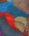
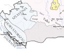
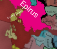
Carpathia and the Balkans start in a very interesting situation. The Kingdom of Hungary probably stands as the most powerful country in 1337, but that only happened after the recovery of the royal power enforced by Charles I Robert of the House of Anjou, who reined in the powerful Hungarian nobility. To the south, the power that is on the rise is the Kingdom of Serbia, ruled by Stefan Uroš IV Dušan, who has set his eyes on his neighbors to expand his power. The Byzantine Empire, meanwhile, is in a difficult position, as internal struggles ended in Andronikos III being crowned sole emperor, at the cost of dividing the realm; both Serbia and Bulgaria have in the past pressed over the bordering lands, while the Ottomans have very recently conquered Nicomedia. The control over the Southern Balkans is also very fractioned, with a branch of the Anjou ruling over Albania, the Despotate of Epirus under the nominal rule of Byzantium as a vassal, Athens, Neopatria and Salona as vassals of the Aragonese Kings of Sicily, Anjou protectorates over Achaia and Naxos, and only nominal Byzantine control over Southern Morea. It’s also noticeable the presence of the Republics of Venice and Genoa, which control several outposts over the Adriatic and Aegean Seas. A final note: in previous maps, Moldavia was shown in the map, but we’ve removed it from it, and it will most likely spawn through a chain of events in the 1340s.

Dynasties:
Dynasties.png

The House of Anjou rules over Naples, Hungary, Albania, Achaia, and Cephalonia; they’re truly invested in their push for supremacy over the region. Apart from that, each country is ruled by different dynasties, except for Athens and Neopatria, ruled by the House of Aragón-Barcelona.

Locations:
Locations 1.png

Locations 2.png

Locations 3.png

Locations 4.png
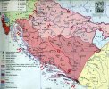
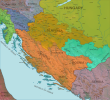
This week we’re posting the general map of the region, along with some more detailed maps, that can be seen if you click on the spoiler button. A starting comment is that the location density of Hungary is noticeably not very high; the reason is that it was one of the first European maps that we made, and we based it upon the historical counties. Therefore, I’m already saying in advance that this will be an area that we want to give more density when we do the review of the region; any help regarding that is welcome. Apart from that, you may notice on the more detailed maps that Crete appears in one, while not being present in the previous one; because of the zooming, the island will appear next week along with Cyprus, but I wanted to make an early sneak peek of the locations, given that is possible with this closer zoom level. Apart from that, I’m also saying in advance that we will make an important review of the Aegean Islands, so do not take them as a reference for anything, please.

Provinces:
Provinces.png

Provinces! Nothing outstanding to be commented on here; as usual, we’re open to any feedback regarding them.

Terrain:
Climate.png

Topography.png

Vegetation.png

Terrain! The climate of the region is mostly divided between Continental and Mediterranean, with some warmer and some colder regions. Regarding the topography, the Carpathian mountains are famously important and strategic, while the Balkans are a quite hilly and mountainous region, which is also greatly covered by woods and forests.

Cultures:
Cultures.png

Here comes the fun part of the DD: The cultural division of the Balkans! A few comments:
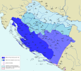
  1. Hungary is full of different minorities. Transylvania, especially, is an interesting place: there we have a mix of ‘Hungarians’, ‘Transylvanians’ (which are the Romanian-speaking inhabitants of the region), ‘Transylvanian Germans’, and ‘Szekely’ people.
  2. We have divided the Southern Slavic-speaking region into their dialectal families of Slovene, Croatian, Bosnian, and Serbian.
  3. The Southern Balkans are mostly divided among Bulgarian, Albanian, and Greek cultures.
  4. We’re also portraying plenty of other cultures, such as Dalmatians, Aromanians, Sclavenes, Arvanites, Cumans, Jasz, or Ashkenazi and Romanyoti Jews.

Religions:
Religion.png

This one is also interesting. Apart from the divide between Western Catholicism and Eastern Orthodoxy, we have the Krstjani in Bosnia, Bogomils (the pink stripes both in Bosnia and Macedonia), and Paulicians in Thrace. The Jewish populations do not pass the threshold percentage to appear on the map, but there are plenty of communities across the region.

Raw Materials:
Raw Materials.png

The materials of the region. Something very noticeable is the richness of minerals, with plenty of Iron, Copper, Tin, Lead, Gold, and Silver. Specifically, Slovakia is very rich, and you definitely want more settlers to migrate to the region, and exploit its resources. The region is also very rich in agricultural resources, as you can see.

Markets:
Markets.png

The region is mostly divided among four markets: Venice, Pest, Ragusa and Constantinople.

Country and Location population:
Population 1.png

Population 2.png

Population 3.png

Population 4.png
Country and location population (which I’ve also sub-divided, and is under the Spoiler button).

And that’s all of today! I hope that you find the region interesting; we certainly think that it is. Next week we will go further south, and we will take a look at the Syrian Levant and Egypt. Cheers!
 
  • 193Like
  • 69Love
  • 7
  • 4
  • 3
  • 1Haha
Reactions:
One thing that comes to mind is that Kastoria in Upper Macedonia, a town reportedly named after the Greek word for beaver, was a center of fur production. That's probably more noteworthy than the beans they're growing in the current setup.


The Devol location (the plateau in the east of Albania, just off of Lake Ohrid) corresponds to the Korçë Plain, which I read was a bog before being drained under Enver Hoxha.
I second both of your comments/suggestions! I remember proposing Fur for EU4's Kastoria, too:
 
  • 1Love
  • 1
Reactions:
Anything that can even remotely be called hills in the red.
I mean tbf that's still like 5 different locations that could/should be hills, though it would be much easier represented with smaller locations and more granularity as currently the locations themselves also cover huge areas with varied terrain that's mostly flat

The source of the problem is that the game doesn't differentiate between the mountain types, like lower and higher mountains. The Carpatians should be Higher Mountains and the other mountains, like Mecsek, the Transdanubian Mountains and the North Hungarian Mountains should be Lower Mountains. Currently technically the hills represent the lower mountains in-game. That's why it's funny that Transdanubia is represented as a flatland. I grew up in Southern Transdanubia, the whole area is hilly with many forests, not grasslands. The area is considered a rich hunting ground even today. So besides hills and forests, I also miss wild games too.
 
Last edited:
  • 1
  • 1Like
  • 1
Reactions:
Some corrections in Thrace and the Marmara sea are needed.

Four locations, two of which should belong to different nations at the start of 1337, a name change, a new location and a border fix for a location

With white names are the locations in need of change, and red the location area that should be given to another location/locations.
sketch-1721046487639.png


-Lets start in the north, Ahtopol was a fishing town that changed hands between the Romans and the Bulgarians numerous times throughout it's history especially in the 13th and 14th centuries. In 1304 the town was conquered by Bulgaria after a failed invasion by the Romans, however it was returned to Byzantium in 1324 after the agreement between the two monarchs. It wouldn't take long for hostilities to flare up again, because in 1331 after the failed invasion of Serbia by the Romans and Bulgarians (the latter of which were not supported by the former) The Byzantines would again launch an invasion of Bulgaria only to once again lose the town and it's surrounding territories after the Bulgarian victory at the battle of Rusokastro in 1332, it will eventually be returned to Byzantine hands in 1366.
IMG_20240715_104100.jpg

IMG_20240715_104139.jpg


- This is pretty simple the name location of Dimotica should be Didymoteicho.
IMG_20240715_103050.jpg


-The Marmara Islands (at the time called Prokonisos from the Greek word proika meaning wealth and nisos meaning island, since many of the royal family had mansions in the Islands and would spend a lot of time there) shown to be part of the location of Bandirma and subsequently the Karasid Beylik. However the Islands would remain a Roman possession until the middle of the 15th century (they were probably conquered along with Constantinople).
IMG_20240715_150135.png

Thus I suggest to make them a separate location in order for them to be a part of Byzantium without the rest of the Bamdirma location which wasn't and shouldn't be depicted as such.


-And finally Biga (or Pegai in Greek). Interestingly Biga would fall (1364) to the Ottoman's much later than the rest of the Byzantine holdings in the Marmara sea. Biga itself was a small outmost rather than a town at the time and it was probably for that reason that the Ottoman's didn't conquer it sooner, seeing it as insignificant.


Now to our game, Biga as a location is extremely big and it reaches a lot further south and west than it should, the Romans had a very tenuous hold of biga itself (let alone so much of it's surroundings) so the location itself should be as small as possible to depict that. So below I have drawn with red the area that should be taken off of biga and given to the two bordering locations of Can and Lapsecki for a more accurate border between the Karasids (and later Ottoman's) and the Byzantines.
IMG_20240715_150033.png

IMG_20240715_104423.jpg

Above is the location of the town (notice how the town doesn't reach that much southwest as the location would suggest).
 

Attachments

  • IMG_20240715_103050.jpg
    IMG_20240715_103050.jpg
    550,9 KB · Views: 0
  • IMG_20240715_103050.jpg
    IMG_20240715_103050.jpg
    550,9 KB · Views: 0
  • IMG_20240715_110504.jpg
    IMG_20240715_110504.jpg
    199,4 KB · Views: 0
  • IMG_20240715_130058.jpg
    IMG_20240715_130058.jpg
    469 KB · Views: 0
  • sketch-1721044635882.png
    sketch-1721044635882.png
    1,1 MB · Views: 0
Last edited:
  • 4
  • 3Like
  • 2
  • 1
Reactions:
Some interesting maps for location/city names and trade goods for early 14th century.
 

Attachments

  • Šubićevska_Hrvatska.jpg
    Šubićevska_Hrvatska.jpg
    443,9 KB · Views: 0
  • Croat_realms_in_the_first_half_of_14th_century.png
    Croat_realms_in_the_first_half_of_14th_century.png
    208,1 KB · Views: 0
  • 1
  • 1Like
Reactions:
Hello there,

so even though this Tinto post has been up for a while, I have a few things to say about particularly Croatia, Slavonia and Dalmatia, though people mentioned the spread of dalmatians before and did a decent job and explaining the demographics of Ragusa in particular for later years already, and about the confusion regarding the "dialects" of Serbo-Croatian (or more accurately for the time, Slavonic), which did not and do not correspond with the modern nation-states of post-yugoslavia, nor the medieval kingdoms that existed in these areas in full, I still have some things to add and want to elaborate and highlight something that a lot of people seem to be unaware of when dealing with Croatia, namely that the Croats in the medieval period really only existed in Dalmatia, with the term fluctuating and being interchangeable with Dalmatian or Sclavonian (the latter of which also encompasses what would today cover Serbs, Bosnians, Montenegrins and Slovenes, as well as in some instances, also Bulgarians).

- Firstly, in 1348 a major plague swept through much of the Mediterranean and had a devastating effect on the population of the Dalmatian coast. P. Skok notes that a whole series of Latin/Italian names, which had been common until then, disappear from the sources. The deceased were in large part replaced by Slavs from the interior, with a smaller number of Italian-speakers migrating from Venetian territory.(1)
Representing that in-game somehow would be ideal as already, Dalmatians are quite overrepresented, especially in northern Dalmatia of what makes up Lika area, where we have no attestation of a Romance population existing whatsoever (this excludes the islands off the coast like Krk, for which we do have well documented romance populations). On the contrary, we do have linguistic evidence for Dalmatians in the region of Hercegovina but that's a purely linguistic hypothesis which I nevertheless thought might be important to mention.(2)
Demographically, after 1348, Latin/Italian remained the language of public life and of official documents, while Slavic dominated in family life, as well as in regular
day-to-day public commerce, so representing the culture should within the first few years shift towards majority Slavic of some sort, while Latin/Italian remains the language of the elites.(3)

- Secondly, the term Dalmatian in this time period being used for the Romance population is problematic to say the least:
In a charter issued in February 1358 to Zadar by Louis of Hungary: “Between them [the Zadranini] and the Croats and other foreigners, let them draw up an agreement.”(4) - Rarely is "Dalmatian" used as an identifying term in the 14th century, and the identify of people didnt just run along linguistic lines, but moreso along regional lines. Especially the Dalmatian cities held a strong sense of patriotism to their own towns first and foremost, be it the Ragusans, Zadrani, Spalatans or what have you. Representing these collectively as Dalmatian, while fine for 1337, might turn into an issue as the game goes on however, as the term Dalmatian became increasingly used by outsiders to refer to the the Slavic speaking population, and was increasingly used by said population itself to refer to themselves and the citizens of the various cities along the coast as they assimilated to each other, be they within Venetian or Croatian territory.(5) This ties into the next point that "Dalmatian" did not just refer to the Romance population, as already in the 14th century we have references to Slavic "Dalmatians" which refers to the enslaved Slavs from the Dalmatian/ Slavic hinterlands who were brought to the Apulian Slave Markets, not the Romance population of the urban cities which were usually identified by said cities.(6)
In the fifteenth century, Venice, which regained all the Dalmatian cities except for Dubrovnik, was starting to call its newly acquired territories collectively "Dalmatia", a term that previously engulfed a rough geographic region, was only then taking on a defined form and the Venetians began to refer to all the inhabitants of this new territory as "Dalmatians", be they Slavic or Romance speakers.(7)
From an outsider perspective, "Slavonia" (henceforth referred to as "Sclavonia") (not to be confused with the modern region of Slavonia in today's northern Croatia, but rather the slavic lands in general (which can to everything from the Dalmatian hinterlands, to Croatia, Bosnia or Serbia)), has become interchangeable with "Dalmatia" by the 14th century already as the population by that point had become so heavily mixed and slavicized.(8) Since then, the term has become commonplace among the local Slavs as well, being used interchangeably with the term "Croatian", and later on, with the emergence of the Renaissance and the revival of ancient naming conventions, also "Illyrian"; the identities of contemporary writers varied and shifted between "Slav", "Croat," "Dalmatian", "Illyrian" and others.(9)

- Thirdly, this ties into a larger main argument, that being that in pre-modern times, there did not exist a clear distinction between many of the South Slavs per se, the focus here being on the regions of what today encompass Croatia and parts of Bosnia as well as Kotor in Montenegro; or rather, they did exist, but in a different regional form. To elaborate on this:
We have many references to Croats in Dalmatia, with the terms "Dalmatian" and "Croatian" being used synonymously often times, but no references to Croats in Slavonia outside of political matters involving Croatian nobility. The region of today's Slavonia, not to be confused with the Sclavonia of Dalmatia (which as mentioned above is part of a larger, generic name for "Lands of the Slavs", covering at times even most of the Balkans), should not be Croatian in 1337. Similar (if not potentially identical to) Slovenes, the Slavs of this area did not possess a separate identity apart from being Slavs. In fact, for 16th century writers, there may have even existed animosity between Croatia and Slavonia; eg. Ivan Tomašić, a Franciscan, composing a chronicle in 1561 writes under the year 1057 (a wrong date, probably closer to 1089), that King Zvonimir was killed by the Slavonians (Slovinci), whom he calls unfaithful and rebellious, while simultaneously praising the faithful Croats and Dalmatians whom he refers to as faifthful brothers and servants, and then blames the Slavonians for the reason why Croatia is under foreign/ Hungarian rule.(10)
It is known that after the Ottoman conquest, many of these Slavonians converted to Islam and later on got subsequently expelled after the Austrians took over the land, though some did remain as their medieval dialects and descendent dialects are still spoken in the west, or in pockets throughout Slavonia.(11) - The land was subsequently turned into a military frontier and resettled with Orthodox and Catholic Slavs, who did however maintain the Slavonian identity regardless of their religious affiliation. Especially in the late modern period up until the 19th century, Slavonia possessed a unique identity and did not identify as part of a single Croatian nation until the 1848 revolution and subsequent events under Austrian, Austro-Hungarian and Yugoslav rule that finally consolidated a common ethnic identity based purely on a shared Catholic religion.(12)
Though even then, a Croatian identity among the catholics was just one of many, as especially in the 17th, 18th and 19th centuries, it competed with regional identities such as Dalmatian or Slavonian, or a more Pan-Slavic (or depending on the author, also regional, as some might consider it to be just another synonym for Dalmatian) Illyrian identity.

South Slavic History is incredibly complex, and biases exist on all sides sadly who wish to revise history to fit a narrative of national continuity throughout history. While this post deals primarily with Croatia (as I've read a lot more about this topic, rather than Serbia or Bosnia), these latter two are equally complex in the formation of their national identities over the course of the early modern period.

Now an argument I also want to respond to that someone might have floating in their head and that I also just realized: if say Croatian in this game is, just like Bosnian, tied to the political entity and not to any single ethnic group, then my argument still stands as Croatia and Slavonia were administered separately by Hungary; Croatia under the Hungarians, exclusively referred to the Coastal territories in Dalmatia to the Adriatic side of the Dinaric Alps, not the fertile plains behind them that are immediately adjacent to Hungary.


TLDR: Slavonia and Croatia should have two separate cultures


The Sources below, they are primarily contemporary writings in Latin and Croatian from Venice, Hungary and Dalmatia/Croatia, but also include modern post-yugoslav and western authors (I have a lot more if necessary, there is no shortage of early modern Renaissance and Enlightenment writers, nor Historical Accounts (both local and foreign) from contemporary and modern times, nor is there a shortage of Poets and Artists who in their contemporary writings make various references to their identities like Vetranović or Zlatarać). - I also attached some maps for visualization

I hope this doesn't get downvoted to oblivion for proposing these changes.


1. P. Skok: “O simbiozi,” Razprave (Znanstveno društvo za humanistične vide v Ljubljáni) 4, 1928, pp. 6–7.
2. A. Kraljevic: Ričnik zapadnoercegovačkoga govora and ričnik izgubljena govora, 2013.
3. P. Skok: “O simbiozi,” p. 22.
4. Codex Diplomaticus Regni Croatiae, Dalmatiae et Slavoniae XII, 1358.
5. Putanec cites a nicknamed individual from each region, the Franciscan Matheus Dalmatinus de Ossero (from Venetian-controlled Osor) and a printer active ca. 1500, Gregory (Grgur) Dalmatinus from Senj; V. Putanec, “Problem predsenjskih tiskara u Hrvatskoj (1482–1493),” Jadranski zbornik 4, 1960, pp. 92–93.
6. In February 1421 Venice noted that many Dalmatians and other similar Slavs were being transported to slave markets in Apulia (Ljubić, Listine VII, p. 278.).
7. Ljubić, Listine VII, p. 281; Ljubić, Listine VIII, pp. 48, 55; Ljubić, Listine VIII, p. 67. etc.
8. Ancona, in discussing its commercial affairs with the Dalmatian cities in the 1380s, consistently referred to the region as “Sclavonia.” (Smičiklas, Codex Diplomaticus Regni Croatiae, Dalmatiae et Slavoniae IX, pp. 189.); Messina, in granting Dubrovnik freedom from customs duties in 1383, described it as being in the region of Sclavonie.(Smičiklas, CD XVI, pp. 133, 139-140, 159); Finally,in 1382 or 1383 the papacy (Urban VI) referred to the Adriatic island of Lastovo as being in the region of Sclavonia.(Smičiklas, CD XVI, pp. 432).
9. Marulić (born in 1450), frequently translated Croatian texts into Latin and refers to the language he translated from by various names, primarily "Croatian", but interestingly, also "Dalmatian" (eg. Ante Split, Hrvatski naslov, p. 7; Hrvatski latinisti I, p. 257.).
10. Ivan Tomašić [Joannis Tomasich], Chronicon breve Regni Croatiae (I. K. S., ed.) Arkiv za jugoslavensku povjestnicu 9, 1868, pp. 13–14.
11. Ive Mažuran – Osnivanje vojne granice u Slavoniji 1702. godine, p. 34.; Andrija Zirdum – Počeci naselja i stanovništvo brodskog i gradiškog kraja 1698-1991, Slavonski Brod, 2001, p. 23-24.
12. M. Biondich, Stjepan Radić: The Croat Peasant Party, and the Politics of Mass Mobilization, 1904–1928, Toronto, 2000.; K. Georgijević, Hrvatska književnost; J. Bukowski, “The Catholic Church and Croatian National Identity: From the Counter-Reformation to the Early Nineteenth Century,” East European Quarterly 13, no. 3, Fall 1979.; etc.
 

Attachments

  • Balkan Map.png
    Balkan Map.png
    283,9 KB · Views: 0
  • Hungary,_Croatia,_Bosnia_and_Galicia_in_the_12th_century.jpg
    Hungary,_Croatia,_Bosnia_and_Galicia_in_the_12th_century.jpg
    629,9 KB · Views: 0
  • Realm_of_Paul_I_Šubić.svg.png
    Realm_of_Paul_I_Šubić.svg.png
    1,4 MB · Views: 0
  • main-qimg-9480945e9b678a5068f01f2acd9b4202-lq.jpeg
    main-qimg-9480945e9b678a5068f01f2acd9b4202-lq.jpeg
    56,4 KB · Views: 0
Last edited:
  • 3Like
  • 3
  • 1Love
  • 1
Reactions:
Some interesting maps for location/city names and trade goods for early 14th century.
"Cakovec" and Srijem was not part of Croatia, but Hungary. Srijem became part of Croatia in 1868, Csáktornya - Cakovec only after 1920. It was part of the County of Zala.
 
  • 2
  • 1Like
  • 1
Reactions:
View attachment 1158260

Dear Pavia it seems that Ikaria and Samos werent included into the Genose Republic untill the 1340's ive done some research on Wiki and it says that Genosese control wasnt introduced untill 1346. It is said that they sold the islands to Genose merchants but they werent offically converted into the Repubic until 1346. I guess im asking when Samos and Ikaria were sold to the Giustiniani family. It seems the family was still under Byzantine susertiy untill they gave the island over to Genoa. After the Byzantine Genoa war the Itatians took all the islands. Their is little infomation on the topic I was curious if you could find documents from greek or italian sources to help clear it up.
 
  • 1Like
Reactions:
This topic in a nutshell:

Eastern Balkans: Noooooo, we are not Wallachians, Moldavians, Transylvanians, we are all Romanians.

Western Balkans: Noooooo, we are not all South Slavic we are Croats, Bosnians, Serbs.

Northern Balkans: Nooooo, there were less Hungarians in Slovakia, Transylvania and northern Serbia than in the Paradox made map.

Southern Balkans: Noooooo, there weren’t that many Turks in Anatolia, there were more Greeks in Anatolia.

Aromanians and Istroromanians: thank you for noticing we exist. We are not Romanians though.

All of them fair points and to be expected. But as a balkaner myself I can’t help but laugh at it.
 
  • 10Haha
  • 1Like
Reactions:
Some corrections in Thrace and the Marmara sea are needed.

Four locations, two of which should belong to different nations at the start of 1337, a name change, a new location and a border fix for a location

With white names are the locations in need of change, and red the location area that should be given to another location/locations.
View attachment 1163650


-Lets start in the north, Ahtopol was a fishing town that changed hands between the Romans and the Bulgarians numerous times throughout it's history especially in the 13th and 14th centuries. In 1304 the town was conquered by Bulgaria after a failed invasion by the Romans, however it was returned to Byzantium in 1324 after the agreement between the two monarchs. It wouldn't take long for hostilities to flare up again, because in 1331 after the failed invasion of Serbia by the Romans and Bulgarians (the latter of which were not supported by the former) The Byzantines would again launch an invasion of Bulgaria only to once again lose the town and it's surrounding territories after the Bulgarian victory at the battle of Rusokastro in 1332, it will eventually be returned to Byzantine hands in 1366.
View attachment 1163639
View attachment 1163640


- This is pretty simple the name location of Dimotica should be Didymoteicho.
View attachment 1163649


-The Marmara Islands (at the time called Prigiponisia meaning prince's isles, for many of the royal family had mansions in the Islands and would spend a lot of time there) shown to be part of the location of Bandirma and subsequently the Karasid Beylik. However the Islands would remain a Roman possession until the middle of the 15th century (they were probably conquered along with Constantinople).
View attachment 1163647
Thus I suggest to make them a separate location in order for them to be a part of Byzantium without the rest of the Bamdirma location which wasn't and shouldn't be depicted as such.


-And finally Biga (or Pegai in Greek). Interestingly Biga would fall (1364) to the Ottoman's much later than the rest of the Byzantine holdings in the Marmara sea. Biga itself was a small outmost rather than a town at the time and it was probably for that reason that the Ottoman's didn't conquer it sooner, seeing it as insignificant.


Now to our game, Biga as a location is extremely big and it reaches a lot further south and west than it should, the Romans had a very tenuous hold of biga itself (let alone so much of it's surroundings) so the location itself should be as small as possible to depict that. So below I have drawn with red the area that should be taken off of biga and given to the two bordering locations of Can and Lapsecki for a more accurate border between the Karasids (and later Ottoman's) and the Byzantines.
View attachment 1163659
View attachment 1163660
Above is the location of the town (notice how the town doesn't reach that much southwest as the location would suggest).
I read your suggestion and I got some small notes:
- Ahtopol to Bulgaria is indeed more correct, even if we don't know how the countryside was divided, exactly. Some other locations got a similar problem, like Strumica and Kocani (which should probably be controlled by Serbia) and even Plovdiv (which should probably be Byzantine, but barely, as the province-borders don't match). That's why I'm fine with Plovdiv going either way.
- Ahtopol itself is just on the northern border of its location, maybe even slightly above it. So, as I mentioned in an earlier suggestion, I'd suggest some rewritten borders.
- Dynamic location-naming isn't functioning properly yet, they're on it. But the mention of Didymoteicho can't hurt.
- You're actually confusing the Princes' Islands (https://el.wikipedia.org/wiki/Πριγκηπόννησα) with Proikonnesos (https://el.wikipedia.org/wiki/Προκόννησος) ;)
- Proikonnesos and the other three islands together are around 200 km2. The smaller islands of the game are bigger, or are located within an island-chain. Kythira (278 km2). Thasos (380 km2), Ikaria (254 km2) and even Malta (316 km2). If Paradox keeps Pantellaria (83 km2) and the Channel Islands (198 km2), then they could indeed add the Marmara Islands, as long as it's indeed the collection of islands and not just the bigger one. Nice suggestion!
- I honestly think Biga's size isn't a biggie (pun intended), as it may have been designed this way for future administrative divisions. Anyway, a bigger hinterland isn't necessarily an issue for exclaves like this.

@aleko12 Locals, discontent with Catholic Genoese rule, probably took over. It was 'official' Genoese territory, already, just not under their full control for a small period of time. The islands were basically in a rebel-ridden transitional phase, gameplay-wise. If I'm not mistaken.
 
Last edited:
  • 4Like
Reactions:
I read your suggestion and I got some small notes:
- Ahtopol to Bulgaria is fine and more correct, even if we don't know how the countryside was divided, exactly. Some other locations got a similar problem, like Strumica and Kocani (which should probably be controlled by Serbia) and even Plovdiv (which should probably be Byzantine, but barely, as the province-borders don't match). That's why I'm fine with Plovdiv going either way.
- Ahtopol itself is just on the northern border of its location, maybe even slightly above it. So, as I mentioned in an earlier suggestion, I'd suggest some rewritten borders.
- Dynamic location-naming isn't functioning properly yet, they're on it. But the mention of Didymoteicho can't hurt.
- You're actually confusing the Princes' Islands (https://el.wikipedia.org/wiki/Πριγκηπόννησα) with Proikonnesos (https://el.wikipedia.org/wiki/Προκόννησος)
- Proikonnesos and the other three islands together are around 200 km2. The smaller islands of the game are bigger, or are located within an island-chain. Kythira (278 km2). Thasos (380 km2), Ikaria (254 km2) and even Malta (316 km2). If Paradox keeps Pantellaria (83 km2) and the Channel Islands (198 km2), then they could indeed add the Marmara Islands, as long as it's indeed the collection of islands and not just the bigger one.
- I honestly think Biga's size isn't a biggie (pun intended), as it may have been designed this way for future administrative divisions. Anyway, a bigger hinterland isn't necessarily an issue for exclaves like this.
Yeah I agree on the Ahtopol Plovdiv notes.

Actually I too have mentioned in a previous post about Strumica and Kocani that they should start under Serbian control.

Fixed the mix up about the name of the Marmara Islands (thank you for pointing that out)

I strongly disagree about Biga and it's not just that location, a lot of coastal locations that should be rather small as the primarily owned only the port and the immediate surroundings of it for example Durres, Lusta and Soldaia (Crimea), Bouthroton in Corfu, Thesalonica, Foca with it's weird long shape and many others as well. All of these need to be much smaller (some less so than others) and not have such a massive inland area as historically they didn't control all of that.
 
Last edited:
  • 1
  • 1Like
Reactions:
This topic in a nutshell:

Eastern Balkans: Noooooo, we are not Wallachians, Moldavians, Transylvanians, we are all Romanians.

Western Balkans: Noooooo, we are not all South Slavic we are Croats, Bosnians, Serbs.

Northern Balkans: Nooooo, there were less Hungarians in Slovakia, Transylvania and northern Serbia than in the Paradox made map.

Southern Balkans: Noooooo, there weren’t that many Turks in Anatolia, there were more Greeks in Anatolia.

Aromanians and Istroromanians: thank you for noticing we exist. We are not Romanians though.

All of them fair points and to be expected. But as a balkaner myself I can’t help but laugh at it.
The ethnic borders that haven't been discussed much are Romania-Serbia, Romania-Bulgaria(or maybe I missed Dobruja discussions?) and Croatia-Hungary I believe
 
  • 1Like
  • 1
Reactions:
A writer of that propaganda that you call a "book" is a president of the anglo-albanian association lmao
Calling everything opposing the Serbian governments 20th century claims for the sake of ethnic cleansing propaganda does not make it true. The book even opposes alot of albanians claims yet you do not care cause if it isnt 100% in line with your nationalist delusions it will simply never be accepted as anything but propaganda.
 
  • 3Like
  • 1Haha
  • 1
Reactions:
Hello there,

so even though this Tinto post has been up for a while, I have a few things to say about particularly Croatia, Slavonia and Dalmatia, though people mentioned the spread of dalmatians before and did a decent job and explaining the demographics of Ragusa in particular for later years already, I still have some things to add and want to elaborate and highlight something that a lot of people seem to be unaware of when dealing with Croatia, namely that the Croats in the medieval period really only existed in Dalmatia, with the term fluctuating and being interchangeable with Dalmatian or Sclavonian (the latter of which also encompasses what would today cover Serbs, Bosnians, Montenegrins and Slovenes, as well as in some instances, also Bulgarians).

I will be presenting this in chronology starting in the 14th century and see how far I get before realizing how truly pointless this whole argument will be and how many downvotes it will get or how it won't be implemented due to gameplay concerns. Anywaaays:

- Firstly, in 1348 a major plague swept through much of the Mediterranean and had a devastating effect on the population of the Dalmatian coast. P. Skok notes that a whole series of Latin/Italian names, which had been common until then, disappear from the sources. The deceased were in large part replaced by Slavs from the interior, with a smaller number of Italian-speakers migrating from Venetian territory.(1)
Representing that in-game somehow would be ideal as already, Dalmatians are quite overrepresented, especially in northern Dalmatia of what makes up Lika area, where we have no attestation of a Romance population existing whatsoever. On the contrary, we do have linguistic evidence for Dalmatians in the region of Hercegovina but that's purely linguistic hypothesis.(2)
Demographically, after 1348, Latin/Italian remained the language of public life and of official documents, while Slavic dominated in family life, as well as in regular
day-to-day public commerce, so representing the culture should within the first few years shift towards majority Slavic of some sort, while Latin/Italian remains the language of the elites.(3)

- Secondly, the term Dalmatian in this time period being used for the Romance population is problematic to say the least:
In a charter issued in February 1358 to Zadar by Louis of Hungary: “Between them [the Zadranini] and the Croats and other foreigners, let them draw up an agreement.”(4) - Rarely is "Dalmatian" used as an identifying term in the 14th century, and the identify of people didnt just run along linguistic lines, but moreso along regional lines. Especially the Dalmatian cities held a strong sense of patriotism to their own towns first and foremost, be it the Ragusans, Zadrani, Spalatans or what have you. Representing these collectively as Dalmatian, while fine for 1337, might turn into an issue as the game goes on however, as the term Dalmatian became increasingly used by outsiders to refer to the the Slavic speaking population, and was increasingly used by said population itself to refer to themselves and the citizens of the various cities along the coast as they assimilated to each other, be they within Venetian or Croatian territory.(5) This ties into the next point that "Dalmatian" did not just refer to the Romance population, as already in the 14th century we have references to Slavic "Dalmatians" which refers to the enslaved Slavs from the Dalmatian/ Slavic hinterlands who were brought to the Apulian Slave Markets, not the Romance population of the urban cities which were usually identified by said cities.(6)
In the fifteenth century, Venice, which regained all the Dalmatian cities except for Dubrovnik, was starting to call its newly acquired territories collectively "Dalmatia", a term that previously engulfed a rough geographic region, was only then taking on a defined form and the Venetians began to refer to all the inhabitants of this new territory as "Dalmatians", be they Slavic or Romance speakers.(7)
From an outsider perspective, "Slavonia" (henceforth referred to as "Sclavonia") (not to be confused with the modern region of Slavonia in today's northern Croatia, but rather the slavic lands in general (which can to everything from the Dalmatian hinterlands, to Croatia, Bosnia or Serbia)), has become interchangeable with "Dalmatia" by the 14th century already as the population by that point had become so heavily mixed and slavicized.(8) Since then, the term has become commonplace among the local Slavs as well, being used interchangeably with the term "Croatian", and later on, with the emergence of the Renaissance and the revival of ancient naming conventions, also "Illyrian"; the identities of contemporary writers varied and shifted between "Slav", "Croat," "Dalmatian", "Illyrian" and others.(9)

- Thirdly, this ties into a larger main argument, that being that in pre-modern times, there did not exist a clear distinction between many of the South Slavs per se, the focus here being on the regions of what today encompass Croatia and parts of Bosnia as well as Kotor in Montenegro; or rather, they did exist, but in a different regional form. To elaborate on this:
We have many references to Croats in Dalmatia, with the terms "Dalmatian" and "Croatian" being used synonymously often times, but no references to Croats in Slavonia outside of political matters involving Croatian nobility. The region of today's Slavonia, not to be confused with the Sclavonia of Dalmatia (which as mentioned above is part of a larger, generic name for "Lands of the Slavs", covering at times even most of the Balkans), should not be Croatian in 1337. Similar (if not potentially identical to) Slovenes, the Slavs of this area did not possess a separate identity apart from being Slavs. In fact, for 16th century writers, there may have even existed animosity between Croatia and Slavonia; eg. Ivan Tomašić, a Franciscan, composing a chronicle in 1561 writes under the year 1057 (a wrong date, probably closer to 1089), that King Zvonimir was killed by the Slavonians (Slovinci), whom he calls unfaithful and rebellious, while simultaneously praising the faithful Croats and Dalmatians whom he refers to as faifthful brothers and servants, and then blames the Slavonians for the reason why Croatia is under foreign/ Hungarian rule.(10)
It is known that after the Ottoman conquest, many of these Slavonians converted to Islam and later on got subsequently expelled after the Austrians took over the land, though some did remain as their medieval dialects and descendent dialects are still spoken in the west, or in pockets throughout Slavonia.(11) - The land was subsequently turned into a military frontier and resettled with Orthodox and Catholic Slavs, who did however maintain the Slavonian identity regardless of their religious affiliation. Especially in the late modern period up until the 19th century, Slavonia possessed a unique identity and did not identify as part of a single Croatian nation until the 1848 revolution and subsequent events under Austrian, Austro-Hungarian and Yugoslav rule that finally consolidated a common ethnic identity based purely on a shared Catholic religion.(12)
Though even then, a Croatian identity among the catholics was just one of many, as especially in the 17th, 18th and 19th century, it competed with regional identities such as Dalmatian or Slavonian, or a more Pan-Slavic (or depending on the other, also regional) Illyrian identity.

South Slavic History is incredibly complex, and biases exist on all sides sadly who wish to revise history to fit a narrative of national continuity throughout history. While this post deals primarily with Croatia (as I've read a lot more about this topic, rather than Serbia or Bosnia), these latter two are equally complex in the formation of their national identities over the course of the early modern period.
Now an argument I also want to respond to that someone might have floating in their head and that I also just realized: if say Croatian in this game is, just like Bosnian, tied to the political entity and not to any single ethnic group, then my argument still stands as Croatia and Slavonia were administered separately by Hungary; Croatia under the Hungarians, exclusively referred to the Coastal territories in Dalmatia to the Adriatic side of the Dinaric Alps, not the fertile plains behind them that are immediately adjacent to Hungary.

The Sources below (I have a lot more if necessary, there is no shortage of early modern Renaissance and Enlightenment writers, nor Historian Accounts (both local and foreign) from contemporary and modern times, nor is there a shortage of Poets and Artists who in their contemporary writing make various references to their identities like Vetranović or Zlatarać). - I also attached some maps for visualization

I hope this doesn't get downvoted to oblivion for proposing these changes.

1. P. Skok: “O simbiozi,” Razprave (Znanstveno društvo za humanistične vide v Ljubljáni) 4, 1928, pp. 6–7.
2. A. Kraljevic: Ričnik zapadnoercegovačkoga govora and ričnik izgubljena govora, 2013.
3. P. Skok: “O simbiozi,” p. 22.
4. Codex Diplomaticus Regni Croatiae, Dalmatiae et Slavoniae XII, 1358.
5. Putanec cites a nicknamed individual from each region, the Franciscan Matheus Dalmatinus de Ossero (from Venetian-controlled Osor) and a printer active ca. 1500, Gregory (Grgur) Dalmatinus from Senj; V. Putanec, “Problem predsenjskih tiskara u Hrvatskoj (1482–1493),” Jadranski zbornik 4, 1960, pp. 92–93.
6. In February 1421 Venice noted that many Dalmatians and other similar Slavs were being transported to slave markets in Apulia (Ljubić, Listine VII, p. 278.).
7. Ljubić, Listine VII, p. 281; Ljubić, Listine VIII, pp. 48, 55; Ljubić, Listine VIII, p. 67. etc.
8. Ancona, in discussing its commercial affairs with the Dalmatian cities in the 1380s, consistently referred to the region as “Sclavonia.” (Smičiklas, Codex Diplomaticus Regni Croatiae, Dalmatiae et Slavoniae IX, pp. 189.); Messina, in granting Dubrovnik freedom from customs duties in 1383, described it as being in the region of Sclavonie.(Smičiklas, CD XVI, pp. 133, 139-140, 159); Finally,in 1382 or 1383 the papacy (Urban VI) referred to the Adriatic island of Lastovo as being in the region of Sclavonia.(Smičiklas, CD XVI, pp. 432).
9. Marulić (born in 1450), frequently translated Croatian texts into Latin and refers to the language he translated from by various names, primarily "Croatian", but interestingly, also "Dalmatian" (eg. Ante Split, Hrvatski naslov, p. 7; Hrvatski latinisti I, p. 257.).
10. Ivan Tomašić [Joannis Tomasich], Chronicon breve Regni Croatiae (I. K. S., ed.) Arkiv za jugoslavensku povjestnicu 9, 1868, pp. 13–14.
11. Ive Mažuran – Osnivanje vojne granice u Slavoniji 1702. godine, p. 34.; Andrija Zirdum – Počeci naselja i stanovništvo brodskog i gradiškog kraja 1698-1991, Slavonski Brod, 2001, p. 23-24.
12. M. Biondich, Stjepan Radić: The Croat Peasant Party, and the Politics of Mass Mobilization, 1904–1928, Toronto, 2000.; K. Georgijević, Hrvatska književnost; J. Bukowski, “The Catholic Church and Croatian National Identity: From the Counter-Reformation to the Early Nineteenth Century,” East European Quarterly 13, no. 3, Fall 1979.; etc.
An added note which I also want to point out but which doesn't really fit into the main post: I find it very unlikely that the Kristjani would exist in coastal Croatia and what is today coastal Bosnia

The area had been part of a series of realms (Venice, Croatia and Hungary) which maintained heavy contact with the Italian and Dalmatian city states, Italy proper and the rest of the Croatian highlands which were predominately catholic. The Bosnian Church was unique because it existed in isolation from the mainstream catholic sphere on the coast and the west, and the orthodox sphere in the north and east.

I don't have any books or sources on this one in particular and it's just something that I find very strange to say the least. You'd expect the Catholic influence to penetrate along with the well documented cultural influence of Italy and Croatia (which I elaborated on in more detail before), and not have the area be apparently isolated from the rest of the Balkans? Would be interesting to know where this comes from and if there's some documentation regarding that, because I am genuinely blank. :)
 
  • 3Like
  • 1
Reactions:
An added note which I also want to point out but which doesn't really fit into the main post: I find it very unlikely that the Kristjani would exist in coastal Croatia and what is today coastal Bosnia

The area had been part of a series of realms (Venice, Croatia and Hungary) which maintained heavy contact with the Italian and Dalmatian city states, Italy proper and the rest of the Croatian highlands which were predominately catholic. The Bosnian Church was unique because it existed in isolation from the mainstream catholic sphere on the coast and the west, and the orthodox sphere in the north and east.

I don't have any books or sources on this one in particular and it's just something that I find very strange to say the least. You'd expect the Catholic influence to penetrate along with the well documented cultural influence of Italy and Croatia (which I elaborated on in more detail before), and not have the area be apparently isolated from the rest of the Balkans? Would be interesting to know where this comes from and if there's some documentation regarding that, because I am genuinely blank. :)
Yeah, I also think Bosnian culture as well as the Bosnian Church is a bit too widespread and should be more confined to the inner parts of Bosnia. I think it's a honest mistake made by the devs.
 
  • 5Like
Reactions:
I had time to write up some changes:


Szabdaka- Subotica (Zabadka) east to Zenta

Kikinda (Kökénd) between Zenta and Temesvár

Vrbas -Verbász Between Nagybecskerek, Szabadka and Bács

Zombor-Sombor (Czoborszentmihály) East of Subotica

Eszék – Ossijek south of Pécs

Siófok Between Somogyvár and Székesfehérvár

Szeged North of Szabadka (or Zenta)

Szigetvár (Zygeth) west of Pécs

Kaposvár between Somogyvár and Pécs

Kecskemét in the Place of Jakabszállás, move Jakabszállás west of Kecskemét and Kiskunfélegyháza

Kanizsa (Knysa) between Segesd and Zalavár

Egerszeg (Egurscug) between Zalavár and Vasvár

Szombathely between Vasvár and Sopron

Kapuvár between Sopron and Győr

Tatabánya between Székesfehérvár and Komárom

Vác vetween Pest and Balassagyarmat

Hatvan and Gyöngyös between Eger

Miskolc between Borsod, Kassa and Zemplén

Hódmezővásárhely between Zenta (or Szeged) and Békes

Szekszárd and Kiskunhalas insted of Bodrog

Györ → Győr

Korosbanya → Körösbánya

Jakeb-Szállása → Jakabszállás

Koloszvár → Kolozsvár

Ilak → Vilak

Csángos in Transilvania

Romani people were around this time in eastern Europe

Either remove „Transilvanian“ and have a single Romanian culture or add a third Romanian Group (Moldovan), having 2 makes no sense

Transilvanian Germans should be called "Siebenbürger"

Greater Hungary:

Preßburg → Pozsony

Holíĉ → Holics

Hlohovec → Galgóc

Banska Bystrica → Besztercebánya (Byzterchebana)

Trenĉín → Trencsén

Liptovský Mikuláŝ → Liptószentmiklós

Oravsky Podzámok → Árvaváralja

Rimavská Sobota → Rimaszombathely

Levoĉa → Lőcse

Leibitz → Leibic

Prešov → Eperjes

Humenné → Homonna

Uẑhorod → Ungvár

Beregovo → Beregszász

Yasine → Kőrösmező

Cuhea → Konyha

Baia Mare → Nagybánya

Zalău → Zilah

Beiuș → Belényes

Dej → Dés

Bästerts → Beszterce

Baia de Arieș→ Aranosbánya

Regen → Szászrégen

Krohnen → Brassó (?)

Schäsbrich → Segesvár

Făgăraș → Fogaras

Medwesch → Medgyes

Melnbach → Szászsebes

Härmeschtat → Nagyszeben

Lugoj → Lugosch

Caransebeș → Karánsebes

Karaševo → Krassóvár

Kovin → Kevevára

Belgrad→ Nándorfehérvár

Sremska Mitrovica → Szávaszentdemeter

Vukovar → Vukovár

Požega → Pozsega

Virovitica→ Verőce

Koprivnica → Kapronca

Bjelovar → Belovár

Pakrac → Pakrác

Čakovec → Csáktornya

Varaždin → Varasd

Zagreb → Zágráb

Petrinja → Petrinya

Slunj → Szluin

Crikvenica → Cirkvenica

Bihać → Bihács

Zadar → Zára

Jajce → Jajca


Others:

Valjevo → Macsókő

Smederevo → Szendrő

Vidin → Bodony

Lovech → Lovecs

Nikopol → Nilápoly

Tarnovo → Tövisvár

Sofia → Szófia (Szeredőc?)

Burgas → Burgasz

Skopje → Szkopje

Shkoder → Szkutari

Dures → Duránc


Greece:

Constantinople → Konstantinápoly

Adrianople → Drinápoly

Rhaedestus → Rodostó

Aenos → Énosz

Gallipoli → Gyelepoly

Thásos → Thászosz

Thghessaloniki → Szaloniki

Mount Ahthos → Athosz-Hegy

Limnos→ Lemnosz

Ioannina → Joánnia

Lárissa → Lárisza

Lesbos → Leszbosz

Kérkyra → Korfu

Leukas → Lefkáda

Zákynthos → Zákinthosz

Thíbia → Thébia

Athinía → Athén

Ródos -_> Rodosz

Náxos → Náxosz


Romania:

Severin → Szörénytornya

Târgu Jiu → Zsilvásárhely

Craiova → Királyi

Argeș → Argyas

Câmpulung Muscel → Hosszúmez

Turnu Măgurele → Kisnikápoly

Giurgiu → Fekete Gyergyó

București → Bukarest

Târgoviște → Tirgovics

Buzău→ Bodzavásár

Brăila → Brajla

Varna → Várna

Tulcea → Tulcsa

Târgu Neamț → Németvásár

Bacău → Bákó

Târgu Trotuș → Tatros

Adjud → Egyedhalma

Focșani → Foksány

Roman → Románvásár

Tecuci → Tekücs

Galați → Galac

Huși → Huszváros

Vaslui → Vászló

Iași → Jászvásár

Orhei → Őrhely

Cîmpulung Moldovenesc → Hosszúmező

Suceava → Szucsáva

Hârlău → Harló

Dorohoi → Dorohoj

Cernăuți → Csernovic​

How deep will the translation system be?
There are hungarian names for places outside of Hungary and her neighbours
Like:
Paris --> Párizs
Kraków --> Krakkó
Danzig --> Dancka
Lviv --> Ilyvó
Leipzig --> Lipcse
...

Will these locations be translatet to?
If yes I may edit this post with more names
 
  • 3Like
Reactions:
Yeah, I also think Bosnian culture as well as the Bosnian Church is a bit too widespread and should be more confined to the inner parts of Bosnia. I think it's a honest mistake made by the devs.
The church in most likelyhood is, but I am no expert on Bosnia; as for the culture however, I am a strong supporter of detaching the cultural terms of the balkans in eu5 from their modern conceptions and making them exclusively related to the state polities that rule over them, because trying to identify the spread of a "Bosnian", "Croatian" or "Serbian" culture in this time period is simply not possible for many reasons (hence why I also prefer the inclusion of a Slavonian culture, or even better, to just merge Croats, Bosnians and Serbs into a single Sclavonic culture). - So the spread of the Bosnian culture is fine as it is imo, but the devs should remember that the kingdom of Bosnia was multi-religous and covered catholics, orthodox and kristjani.

We cant really draw hard lines in the cultural aspect, but we have plenty of written accounts by missionaries, priests, travellers and more who dive into the religious landscape of the Balkans when it comes to church matters and certain practices, hence why we know that Bosnia was multi-religious.
Early on in the 15th century, the ruling dynasty even converted to catholicism, but calling them Croats would be a stretch based on a modern preconception that catholic slavs equals croats. It's important to detach the concept of "religion = culture" notion in these pre-modern and pre-ottoman times
 
Last edited:
  • 5Like
Reactions:
Regarding my home region (from my mother's side) I would like to point out that Leukada (or leukas) in 1337 was under the rule of Walter VI of Brienne count of Brienne at the time (The Palatine of Cephalonia and Zakynthos would come to control Leukada and Vonitsa in the later decades of the 14th century).
IMG_20240716_123039.jpg

IMG_20240715_130058.jpg

He also captured the fortress of Vonitsa in the mainland and the areas surrounding it. Now am not quite sure how to depict this state as the county of Brienne doesn't exist in the French Tinto maps, maybe you could have it as its own fief altogether?


However the location of Vonitsa extends a lot more inwards than it should. So am suggesting to split the Vonitsa location in two, Vonitsa closer to the coast and Amphilochia further to the east
sketch-1721134680396.png

I also split the quite large Angelokastro location in two with Agrinio having the east portion of the Angelokastro location.


The original locations for comparison.
IMG_20240715_133705.png

You can see how massive the Angelokastro location is, in contrast to the locations in the Peloponnese, as you easily fit three, maybe even four locations in there.


The region should look more or less something like this. Am not very sure about the name of the county of Leukas (since from my knowledge there wasn't a Leukas county in the middle ages) but since there isn't a Brienne county to give it too I think this is the second best thing we have.
sketch-1721136061385.png

Any suggestions or corrections you may have let me know.
 

Attachments

  • IMG_20240715_130058.jpg
    IMG_20240715_130058.jpg
    469 KB · Views: 0
  • sketch-1721135585650.png
    sketch-1721135585650.png
    770,2 KB · Views: 0
Last edited:
  • 7Like
  • 2
Reactions:
Please let us rely on historical sources when it comes to Hungary - whether someone feels it's difficult to accept or not. Here is a map from the 11th century:
1721141132342.png

And here is a map from the 15h century:
1721141705343.png

After Matthias' death, you can see that the repopulation of Hungary (which started right after the Tatars pillaged the kingdom) was still underway, and even by the end of the 15th century, their numbers weren't as high as presented on the map (or the areas where they're shown as present are in fact, still unpopulated). This of course applies to each ethnicity in the whole kingdom, not just Transylvania.

The 2nd thing is the name of the Transylvanian Romanians. It is incorrect to say that "Transylvanian" relates to Romanians only; Transylvania was and still is a region home to many-many ethnicities, including, but not limited to Romanians. Transylvania especially in this time period, could be considered a multi-ethnic region like today's Switzerland or Belgium; and the terms "Swiss" and "Belgian" don't mean an ethnicity, but people living in said regions: inhabitants. I would like to recommend using the same term as for Wallachians and Moldovans, despite the fact that all 3 of them had slightly different cultures, as they still belong to one category, and the Transylvanian Romanians are actually just settlers from the other two regions.
I hope these notices will be noted!

Edit: I wished to apply sources, but the website did not let me send them as it marked them either as spam or inappropriate. Hence here is the link where all of these information can be accessed: wiki/Betelepülések_és_betelepítések_Magyarországra
 
  • 4
  • 3
  • 1Like
  • 1
Reactions: