• We have updated our Community Code of Conduct. Please read through the new rules for the forum that are an integral part of Paradox Interactive’s User Agreement.

Tinto Maps #9 - 5th of July 2024 - Carpathia and the Balkans

Greetings, and welcome to another Tinto Maps! This week we will be taking a look at Carpathia and the Balkans! It will most likely be an interesting region to take a look at, with a lot of passion involved… So I’ll just make an initial friendly reminder to keep a civil discussion, as in the latest Tinto Maps, as that’s the easiest way for us to read and gather your feedback, and improve the region in a future iteration. And now, let’s start with the maps!

Countries:
Countries.png

Carpathia and the Balkans start in a very interesting situation. The Kingdom of Hungary probably stands as the most powerful country in 1337, but that only happened after the recovery of the royal power enforced by Charles I Robert of the House of Anjou, who reined in the powerful Hungarian nobility. To the south, the power that is on the rise is the Kingdom of Serbia, ruled by Stefan Uroš IV Dušan, who has set his eyes on his neighbors to expand his power. The Byzantine Empire, meanwhile, is in a difficult position, as internal struggles ended in Andronikos III being crowned sole emperor, at the cost of dividing the realm; both Serbia and Bulgaria have in the past pressed over the bordering lands, while the Ottomans have very recently conquered Nicomedia. The control over the Southern Balkans is also very fractioned, with a branch of the Anjou ruling over Albania, the Despotate of Epirus under the nominal rule of Byzantium as a vassal, Athens, Neopatria and Salona as vassals of the Aragonese Kings of Sicily, Anjou protectorates over Achaia and Naxos, and only nominal Byzantine control over Southern Morea. It’s also noticeable the presence of the Republics of Venice and Genoa, which control several outposts over the Adriatic and Aegean Seas. A final note: in previous maps, Moldavia was shown in the map, but we’ve removed it from it, and it will most likely spawn through a chain of events in the 1340s.

Dynasties:
Dynasties.png

The House of Anjou rules over Naples, Hungary, Albania, Achaia, and Cephalonia; they’re truly invested in their push for supremacy over the region. Apart from that, each country is ruled by different dynasties, except for Athens and Neopatria, ruled by the House of Aragón-Barcelona.

Locations:
Locations 1.png

Locations 2.png

Locations 3.png

Locations 4.png
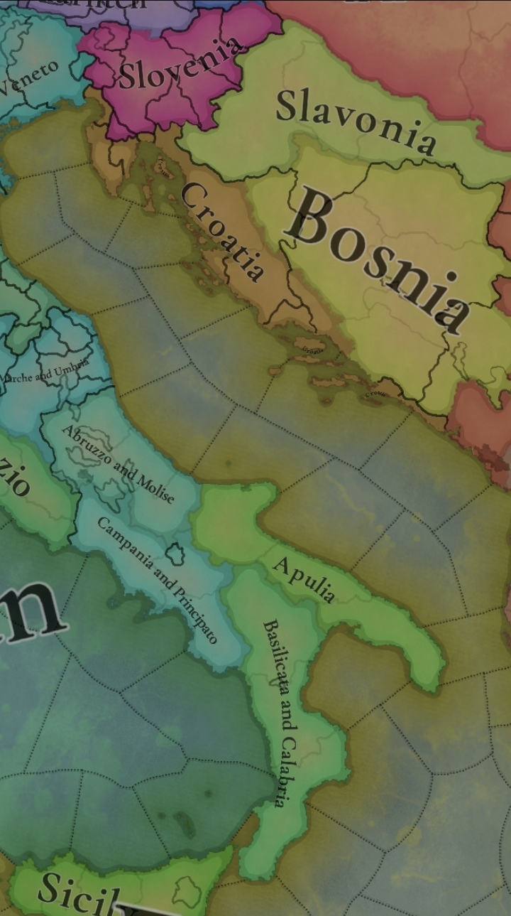
This week we’re posting the general map of the region, along with some more detailed maps, that can be seen if you click on the spoiler button. A starting comment is that the location density of Hungary is noticeably not very high; the reason is that it was one of the first European maps that we made, and we based it upon the historical counties. Therefore, I’m already saying in advance that this will be an area that we want to give more density when we do the review of the region; any help regarding that is welcome. Apart from that, you may notice on the more detailed maps that Crete appears in one, while not being present in the previous one; because of the zooming, the island will appear next week along with Cyprus, but I wanted to make an early sneak peek of the locations, given that is possible with this closer zoom level. Apart from that, I’m also saying in advance that we will make an important review of the Aegean Islands, so do not take them as a reference for anything, please.

Provinces:
Provinces.png

Provinces! Nothing outstanding to be commented on here; as usual, we’re open to any feedback regarding them.

Terrain:
Climate.png

Topography.png

Vegetation.png

Terrain! The climate of the region is mostly divided between Continental and Mediterranean, with some warmer and some colder regions. Regarding the topography, the Carpathian mountains are famously important and strategic, while the Balkans are a quite hilly and mountainous region, which is also greatly covered by woods and forests.

Cultures:
Cultures.png

Here comes the fun part of the DD: The cultural division of the Balkans! A few comments:
  1. Hungary is full of different minorities. Transylvania, especially, is an interesting place: there we have a mix of ‘Hungarians’, ‘Transylvanians’ (which are the Romanian-speaking inhabitants of the region), ‘Transylvanian Germans’, and ‘Szekely’ people.
  2. We have divided the Southern Slavic-speaking region into their dialectal families of Slovene, Croatian, Bosnian, and Serbian.
  3. The Southern Balkans are mostly divided among Bulgarian, Albanian, and Greek cultures.
  4. We’re also portraying plenty of other cultures, such as Dalmatians, Aromanians, Sclavenes, Arvanites, Cumans, Jasz, or Ashkenazi and Romanyoti Jews.

Religions:
Religion.png

This one is also interesting. Apart from the divide between Western Catholicism and Eastern Orthodoxy, we have the Krstjani in Bosnia, Bogomils (the pink stripes both in Bosnia and Macedonia), and Paulicians in Thrace. The Jewish populations do not pass the threshold percentage to appear on the map, but there are plenty of communities across the region.

Raw Materials:
Raw Materials.png

The materials of the region. Something very noticeable is the richness of minerals, with plenty of Iron, Copper, Tin, Lead, Gold, and Silver. Specifically, Slovakia is very rich, and you definitely want more settlers to migrate to the region, and exploit its resources. The region is also very rich in agricultural resources, as you can see.

Markets:
Markets.png

The region is mostly divided among four markets: Venice, Pest, Ragusa and Constantinople.

Country and Location population:
Population 1.png

Population 2.png

Population 3.png

Population 4.png
Country and location population (which I’ve also sub-divided, and is under the Spoiler button).

And that’s all of today! I hope that you find the region interesting; we certainly think that it is. Next week we will go further south, and we will take a look at the Syrian Levant and Egypt. Cheers!
 
  • 193Like
  • 69Love
  • 7
  • 4
  • 3
  • 1Haha
Reactions:
Hello!

I have tried to illustrate in the attached image some colour changes that I think would improve readability.

This is also a personal preference - I think that the yellow / wheat colour for Romania / Wallachia from V2 / HoI4 / CK3 fits best, unlike the more recent blue, and in the context of the Project Caesar map it would certainly distinguish us from our neighbours.

I have also tried to implement the green that I have seen suggested for the Bulgarians, light blue for the Greeks and a vibrant red for the Turks.

I hope you like my suggestion, best regards!

View attachment suggestion_colours.png
 
  • 4Love
  • 3Like
Reactions:
So I have already expressed how I would prefer to split up the areas in Hungary, but given how this sneak peek from the Italy Feedback post shows that the original intention was for the entirety of Hungary to be one single gigantic area, I took the liberty to just explain them again just to be sure.

Screenshot_20240716_175332_Chrome.jpg


So the areas in Europe shown so far range in size from approximately 18000 km² to approximately around 50000 km² in area, and they control a handful of provinces sort of. Given that the area of the Kingdom of Hungary proper is around 280 thousand km², it is way too large for a single area no matter how we look at it. It is almost double of the largest currently known area, the Levant, which is also extremely large.

I am not going to give a proposal on locations and provinces, I think @purplephoton did an excellent job at that earlier in the thread, and I have made some comments and corrections on their proposal following it.
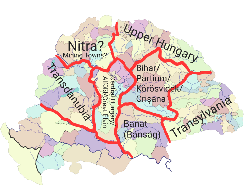
Without giving a detailed map, just a quick mockup or guideline:
800px-Magyarország_a_középkorban.png


The three most clearly defined historical areas within Hungary are Transdanubia (Dunántúl) (everything "across" the Danube, the counties of Vas, Zala, Somogy, Tolna, Baranya, Veszprém, Fejér, Komárom, Esztergom, Győr-Moson-Sopron etc. The historical county borders don't follow the Danube always, but it is close enough), Banat or Bánság (the rectangular area bordered by the Maros (Mureş), the Danube, Wallachia and Transylvania; it covers the area of counties such as Krassó, Torontál, and Temes, and also most of Csanád and Arad, so I do think they should also belong in this area due to the city of Arad itself also being in this area; existed as a military frontier area between 1718-1778), and of course the fan-favourite Transylvania (whose traditional boundaries are well defined). The Banat is 28500 km², Transylvania is 57000 km², and Transdanubia is around 38000 km², so these are in the range of areas already seen.

The rest of the land is tricky to shape into well-defined areas. For the Highlands of what's today Slovakia, Slovakia might work as a name for the whole region, but it is kind of historical anachronism, as the name didn't in a way that applied to the whole region, and is kind of large too. Thus I would split it in two, the Eastern half based on Upper Hungary, and the Western half on either the Captaincy of the Mining Towns, or perhaps the medieval Principality and later Duchy of Nitra/Nyitra.
800px-Central_europe_1572 (1).png
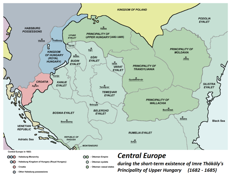
Central_europe_1683.png


Upper Hungary (Felső-Magyarország) today is often confused with the modern term Felvidék, a term by Hungarian irredentists referring to the entirety of modern Slovakia, but this is false, the historical meaning that referred to the Captaincy it covered consisted of the 13 counties of Borsod, Abaúj, Zemplén, Szabolcs, Szatmár, Bereg, Ugocsa, Ung, Sáros, Szepes, Gömör, Torna and Heves–Külső-Szolnok in the early modern era. I did not include the Szabolcs-Szatmár region in it in my map, because I thought it was more fitting in Bihar, and included Maramaros because I could not find a better place for it without creating a pretty small Transcarpathia area. For a brief period, the Principality of Upper Hungary existed, which occupied more territories to the West too, but otherwise being a cool option of a creatable tag,
The Captaincy of the Mining Towns was also called Lower Hungary, but I think such a name would be confusing and weird without context (it made sense to the Vienna- and Pressburg-centric Early Modern administration, when Royal Hungary was but a narrow strip), so I think Nitra/Nyitra would be better. The first capital/headquarters of the Captainct of the Mining Towns was also the city of Nitra.

The "buffer zone" of the Great Hungarian Plains is not well-defined, but I think a two-way split would be the best: one for Central Hungary, consisting of the counties primarily between the Danube and the Tisza, like Pest, Szolnok, Bács-Bodrog, and the Sedes of the Jászkun district. It could also be called Central Hungary, Alföld, or the Great Plains.
The Bihar area, centered around Várad and the county of Bihar, is kind of a mish-mash of different, coinciding historical regions, such as the Duchy of Bihar, the Partium (parts of Hungary that were not historically and officially part of Transylvania but were under the control of the Principality of Transylvania), and Crişana or Körösvidék, which fits the area very well but it is slightly anachronistic.
 
Last edited:
  • 5Like
  • 2
  • 1
Reactions:
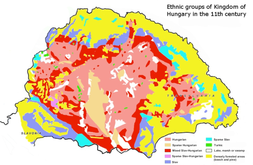
Please let us rely on historical sources when it comes to Hungary - whether someone feels it's difficult to accept or not. Here is a map from the 11th century:
1721150494715.png
Ethnic map which instead of slovenes, saxons, romanians, ruthenians, croats and jews, show us "densely forested areas and marshes" . Okay! Thanks!!! Based hungary academy of history
 
  • 8Haha
  • 6Like
  • 1
Reactions:
If Italy and France are split in dialects why not Albanian?
Too small tbf and would probably impact Albania negatively gameplay-wise because it might make it harder to unify it like in the League of Lezhë. While you want Italy to stay fragmented for the whole game, the tendency for Albanians would probably be unification in the early eras by my understanding of Albanian history
 
  • 5Like
Reactions:
If Italy and France are split in dialects why not Albanian?
Small culture with a strongly unified identity, micronationalisms of which happened on a clan/lineage basis rather than a dialect/region basis.
 
  • 2Like
Reactions:
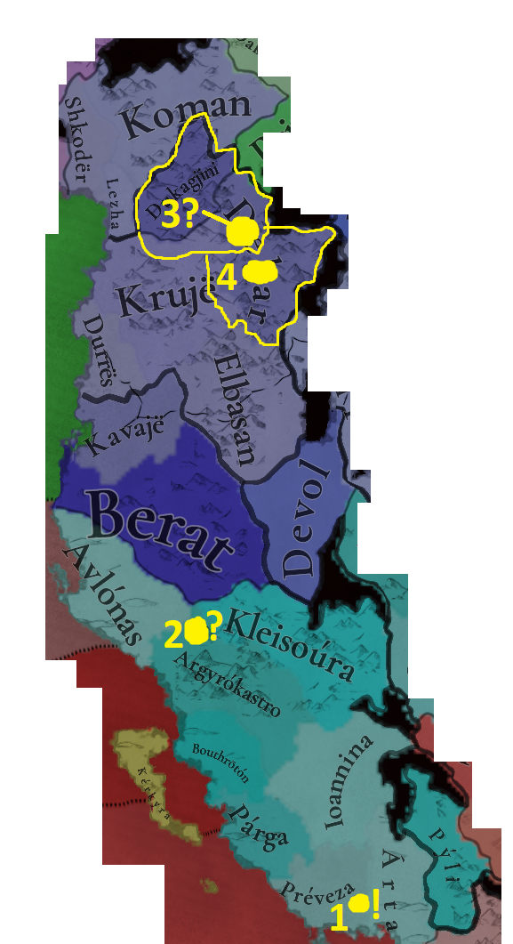
Albania and Epirus. Another headache, and not in terms of locations, but in terms of tags. Which isn't my specialty regarding this area, so I'll leave that to other people. So, before I go to my location-check, I'll start by making some comments about these tags:
- The area was basically under control of either the Angevins, the Byzantine Empire or the Despotate of Epirus. Some areas under direct control, like Durrës and Bouthrotón (both Angevin), and a lot only nominal. Bouthrotón should be a bit smaller, as it was an exclave (@DOURIOS mentioned this as well).
- That's where the fun begins: Which nominal areas where controlled by which of these 3 tags? Or, if the developers feel particularly brave: Under which Albanian clan/family?
- One way or another, the current setup doesn't do the area justice yet. There need to be some tweaks. For example: The Despotate probably didn't have nominal control over that much of Albania (unless I'm just very mistaken). And the Angevins probably didn't have nominal control over such a large area, either.
- Some players would really like the Albanian clans to have more prominence on the map. Clans/families like the Thopia and the Muzaka. The question then however is, which areas did they actually control? And should they be under vassalage or not?
- I'll leave the tag-discussion at that... So, if anyone got some good sources/maps on this matter, that'd be appreciated.
Albania and Epirus.png


But onwards to my 'specialty'! Location-checks.
Here we go:
1: Árta is located somewhere around that yellow dot and might be slightly located within the Préveza location. I'd rewrite those borders, just in case.
2: Same for Kleisoúra, basically.
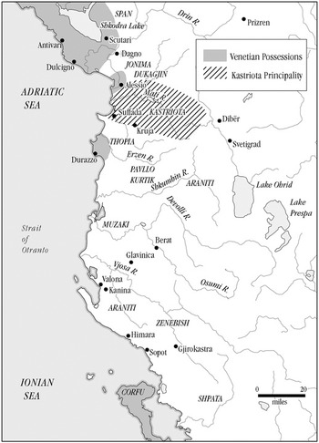
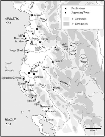
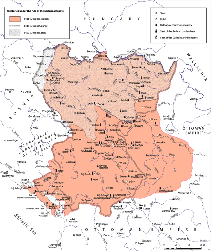
3 and 4: Dukagjini is a small village, but the political center of the Dukagjini family was actually located at Lezhë (before it was handed over to the Venetians). Even though Albania's towns slowly started development into bigger urban centers, none of the maps I've seen of both Medieval Albania as well as Serbia depict this area. It seems as if this village has always been that; Small.
Some maps from the 14th/15th centuries:
Map 2.jpg

Map 1.jpg

Nemanjid Expansion.PNG
465109_1_En_3_Fig7_HTML.png

But! Which town was actually located within this location's vicinity? Peshkopi/Peshkopia (https://en.wikipedia.org/wiki/Peshkopi it was inhabited in the 14th century, but started properly developing during Ottoman times, like a lot of the Albanian towns). A worty addition, but one which requires some small changes to the borders of this location as well as Debar's and Krujë's.
 
Last edited:
  • 3Like
  • 1
Reactions:
Ethnic map which instead of slovenes, saxons, romanians, ruthenians, croats and jews, show us "densely forested areas and marshes" . Okay! Thanks!!! Based hungary academy of history
I'd assume that "Based" is a compliment to applaud how fundamental their research on the subject is, but then some people laugh - which makes me somewhat confused.
 
  • 5Haha
  • 1Like
Reactions:
Albania and Epirus. Another headache, and not in terms of locations, but in terms of tags. Which isn't my specialty regarding this area, so I'll leave that to other people. So, before I go to my location-check, I'll start by making some comments about these tags:
- The area was basically under control of either the Angevins, the Byzantine Empire or the Despotate of Epirus. Some areas under direct control, like Durrës and Bouthrotón (both Angevin), and a lot only nominal. Bouthrotón should be a bit smaller, as it was an exclave (@DOURIOS mentioned this as well).
- That's where the fun begins: Which nominal areas where controlled by which of these 3 tags? Or, if the developers feel particularly brave: Under which Albanian clan/family?
- One way or another, the current setup doesn't do the area justice yet. There need to be some tweaks. For example: The Despotate probably didn't have nominal control over that much of Albania (unless I'm just very mistaken). And the Angevins probably didn't have nominal control over such a large area, either.
- Some players would really like the Albanian clans to have more prominence on the map. Clans/families like the Thopia and the Muzaka. The question then however is, which areas did they actually control? And should they be under vassalage or not?
- I'll leave the tag-discussion at that... So, if anyone got some good sources/maps on this matter, that'd be appreciated.
View attachment 1164215

But onwards to my 'specialty'! Location-checks.
Here we go:
1: Árta is located somewhere around that yellow dot and might be slightly located within the Préveza location. I'd rewrite those borders, just in case.
2: Same for Kleisoúra, basically.
3 and 4: Dukagjini is a small village, but the political center of the Dukagjini family was actually located at Lezhë (before it was handed over to the Venetians). Even though Albania's towns slowly started development into bigger urban centers, none of the maps I've seen of both Medieval Albania as well as Serbia depict this area. It seems as if this village has always been that; Small.
Some maps from the 14th/15th centuries:
View attachment 1164218
View attachment 1164219
View attachment 1164220View attachment 1164221
But! Which town was actually located within this location's vicinity? Peshkopi/Peshkopia (https://en.wikipedia.org/wiki/Peshkopi it was inhabited in the 14th century, but started properly developing during Ottoman times, like a lot of the Albanian towns). A worty addition, but one which requires some small changes to the borders of this location as well as Debar's and Krujë's.
Actually I have been working on this area for a while now and I am almost done, It would probably take some more days but I think it would come out ok.
 
Last edited:
  • 1Love
  • 1Like
Reactions:
Actually I have been working on this area for a while and I think it's mostly fine It would probably take some more days but I think it would come out ok
I'm very curious what your findings are! ;)
 
I'm very curious what your findings are! ;)
Well a lot of locations have been split, a few changed borders. You know I am REALLY tempted to show the map changes right now...but I don't think it will do very good without me explaining how I made that decision for that particular border, there are quite a few changes to be honest.
 
  • 1
Reactions:
Well a lot of locations have been split, a few changed borders. You know I am REALLY tempted to show the map changes right now...but I don't think it will do very good without me explaining how I made that decision for that particular border, there are quite a few changes to be honest.
Yeah, take your time! My takes are generally more 'conservative', keeping the devs' granularity. I'm mostly fine with the current density of the Balkans, but still looking forward to your suggestions.

I'm currently going over Bosnia, Hercegovina and Montenegro. The latter has some slight issues that need adressing.
 
Last edited:
  • 3Like
Reactions:
I am not going to give a proposal on locations and provinces, I think @purplephoton did an excellent job at that earlier in the thread, and I have made some comments and corrections on their proposal following it.

So most of this is just naming semantics, but:
My original proposition of areas had "West Slovakia" to represent the Mining Towns and "East Slovakia" for Upper Hungary to avoid confusion with any imperialist/nationalist Hungarian sentiments. While the other terms might be more historically accurate, I chose to stick with two Slovakias, as the term "Slovak" dates back to the early part of PC's timeframe.
I also organized my areas further south roughly based on Ottoman eyalets, with Budin Eyalet roughly corresponding to Duna area, Egri Eyalet roughly corresponding to Great Plain, and Temesvar Eyalet roughly corresponding to Banat. I also chose to split Transylvania into a Szekely/German/Transylvanian Upper and a Hungarian/Ruthenian/Transylvanian Lower parts out of convenience. The Partium was a bit of an inconvenience, and I chose to group it with Great Plain for geographical reasons, but I'm open to the idea of having it as its own area stretching from Bihar to Bereg (perhaps leading to a combined Transylvania).
 
Last edited:
  • 3Like
Reactions:
Went through the Ottoman administrative divisions of the area to see what other locations could be added. Definitely not comprehensive by any means!
  • Crete:
    • Agios Pavlos -> Hora Sfakion/Sfakia
      • Late seat of an Ottoman Sanjak; notable for resistance to Ottoman rule
    • Elounda -> Ierapetra
      • Prosperous under Venetian rule

  • Mainland Greece:
    • Methoni -> Pylos/Navarino
      • More important during period? Ottoman Naval base
    • Kalamata -> split northern part into Leontari?
      • Briefly capital of Morea Sanjak (between Corinth and Mystras)
      • Unsure of resource
    • Loidoriki -> Lidoriki?
    • Demotica/Didymoteicho -> Split northwestern part into Ormenio/Çirmen
      • Seat of Sanjak of the same name from 1371-1829
      • Unsure of resource

  • Bosnia & Herzegovina:
    • Ustikolina -> Foča
      • Capital of the Sanjak of Herzegovina from 1470-1572
    • Srebrenik/Soli -> Split eastern part into Zvornik
      • Capital of Zvornik Sanjak
      • should produce Fruit or lumber
    • Zenica -> Split western part into Travnik
      • capital of Bosnia Eyalet from 1699-1832; fortified town
      • Livestock?
    • Kljuc/Doboj/Jajce -> add Vrbas (Banja Luka)
      • Capital of Bosnia Eyalet from 1553-1639
      • unsure of resource – maybe Lumber?

  • Kosovo:
    • Pristina -> Split northern part into Vushtrri
      • Capital of Viçitrina sanjak
      • Should produce Silver (Kapaonik mines)

  • Turkey:
    • Medea -> Vize/Bizyi
      • Capital of Vize Sanjak

  • Romania:
    • Zarand/(Zărand) -> Ineu
      • Capital of the Temeşvar Eyalet in the 2nd half of the 17th century
    • Arad -> Split eastern part into Lipova
      • Capital of Sanjak of Lipva; strategic location with fortresses
      • unsure of resource
    • Csongrad-> Szeged
      • Capital of Sanjak of Segedin; capital of Csongrad county since 1241
    • Myhald(Mehádia) -> Orșova
      • Capital of Sanjak of Orşova; Mehádia seems to have been rebuilt in 1735?
    • Bihar(Biharia) -> Oradea(Nagyvárad)
      • Capital of Bihar county since 1083; capital of Varat Eyalet
      • Can maybe also break out a Culisir; Salonta location? Salonta replaced Culisir after it was destroyed in 1598 and became a sanjak seat
      • Livestock? Seems to be known for its pigs/sausage

  • Serbia:
    • Kovin -> Split western part into Pančevo
      • Capital of Sanjak of Pançova
      • can produce Wheat?
    • Bodrog/Zenta(Senta) -> Squeeze in Subotica?
      • Sanjak capital
      • Fruit, Wine, or Wheat?
      • Bodrog should shift to Sombor at some point
    • Bacs -> Split eastern part into Titel
      • Sanjak capital; important strategic location; Livestock, fish, or wild game?

  • Hungary:
    • Bodrog -> Split northern half into Baja
      • Significant fortress town
      • Could produce Wheat?
    • Pecs -> Split eastern part into Mohacs
      • Famous for 2 battles; Sanjak capital
      • Produces Wheat?
      • Can also split the southern part into Siklós
        • Sanjak Capital
        • seems to have produce wine in the later period of the game, but unsure at game start
      • Can also also split western part into Szigetvár
        • Sanjak Capital
        • unsure of resource
    • Jakeb-Szallasa -> Kecskemét
      • Sanjak Capital
      • Livestock/cattle
    • Segesd -> Split southern half into Babócsa
      • Sanjak Capital
      • Legumes (name comes from word for bean)?
    • Balassagyarmat(/Eger?) -> Split to add Hatvan (hard to tell its exact location on the map)
      • Sanjak Capital
      • Livestock or Wine?
      • Also split off northern part of Balassagyarmat to add Fiľakovo (Slovakia)
        • Castle town and Sanjak Capital
        • unsure of resource
      • Also also split off eastern part of Balassagyarmat to add Szécsény
        • Sanjak seat
        • Unsure of resource
    • Hont/Balassagyarmat -> Split off Nógrád (or maybe Balassagyarmat -> Nógrád?)
      • capital of the county (moved to Balassagyarmat in the 18th c.); Sanjak center
      • unsure of resource
    • Tolnavár(/Székesfehérvár) -> split northern end to make Simontornya
      • Sanjak Capital
      • livestock (Leather)
      • Not sure if there’s room to split off Szekszárd here, maybe bottom half of what’s left of Tolnavar
    • Somogyvar -> Split off eastern half to make (Török)koppány
      • Sanjak Capital
      • Produces wine?
    • Zalavár -> Split Southwestern part into (Nagy)Kanisza
      • Capital of the Kanije Eyalet; castle town
      • unsure of resource

  • Croatia:
    • Might be tight with Vukovar, but Osijek should be included here, taking space from Vukovar/Pecs? (Definitely not room for Valpovo as well)
    • Unsure of resource.

  • Slovakia:
    • Nyitra/Obars -> Take southern half to create Nyárhíd or Lék (Nové Zámky)
      • Important fortress city; Eyalet capital
      • Livestock or wheat?
    • Hlohovec -> Take eastern half to create Levice
      • Sanjak Capital
      • produces wine
 
Last edited:
  • 2Like
  • 2Love
Reactions:
So I have already expressed how I would prefer to split up the areas in Hungary, but given how this sneak peek from the Italy Feedback post shows that the original intention was for the entirety of Hungary to be one single gigantic area, I took the liberty to just explain them again just to be sure.

View attachment 1164080

So the areas in Europe shown so far range in size from approximately 18000 km² to approximately around 50000 km² in area, and they control a handful of provinces sort of. Given that the area of the Kingdom of Hungary proper is around 280 thousand km², it is way too large for a single area no matter how we look at it. It is almost double of the largest currently known area, the Levant, which is also extremely large.

I am not going to give a proposal on locations and provinces, I think @purplephoton did an excellent job at that earlier in the thread, and I have made some comments and corrections on their proposal following it.
Without giving a detailed map, just a quick mockup or guideline:
View attachment 1164099

The three most clearly defined historical areas within Hungary are Transdanubia (Dunántúl) (everything "across" the Danube, the counties of Vas, Zala, Somogy, Tolna, Baranya, Veszprém, Fejér, Komárom, Esztergom, Győr-Moson-Sopron etc. The historical county borders don't follow the Danube always, but it is close enough), Banat or Bánság (the rectangular area bordered by the Maros (Mureş), the Danube, Wallachia and Transylvania; it covers the area of counties such as Krassó, Torontál, and Temes, and also most of Csanád and Arad, so I do think they should also belong in this area due to the city of Arad itself also being in this area; existed as a military frontier area between 1718-1778), and of course the fan-favourite Transylvania (whose traditional boundaries are well defined). The Banat is 28500 km², Transylvania is 57000 km², and Transdanubia is around 38000 km², so these are in the range of areas already seen.

The rest of the land is tricky to shape into well-defined areas. For the Highlands of what's today Slovakia, Slovakia might work as a name for the whole region, but it is kind of historical anachronism, as the name didn't in a way that applied to the whole region, and is kind of large too. Thus I would split it in two, the Eastern half based on Upper Hungary, and the Western half on either the Captaincy of the Mining Towns, or perhaps the medieval Principality and later Duchy of Nitra/Nyitra.
View attachment 1164140View attachment 1164151

Upper Hungary (Felső-Magyarország) today is often confused with the modern term Felvidék, a term by Hungarian irredentists referring to the entirety of modern Slovakia, but this is false, the historical meaning that referred to the Captaincy it covered consisted of the 13 counties of Borsod, Abaúj, Zemplén, Szabolcs, Szatmár, Bereg, Ugocsa, Ung, Sáros, Szepes, Gömör, Torna and Heves–Külső-Szolnok in the early modern era. I did not include the Szabolcs-Szatmár region in it in my map, because I thought it was more fitting in Bihar, and included Maramaros because I could not find a better place for it without creating a pretty small Transcarpathia area. For a brief period, the Principality of Upper Hungary existed, which occupied more territories to the West too, but otherwise being a cool option of a creatable tag,
The Captaincy of the Mining Towns was also called Lower Hungary, but I think such a name would be confusing and weird without context (it made sense to the Vienna- and Pressburg-centric Early Modern administration, when Royal Hungary was but a narrow strip), so I think Nitra/Nyitra would be better. The first capital/headquarters of the Captainct of the Mining Towns was also the city of Nitra.

The "buffer zone" of the Great Hungarian Plains is not well-defined, but I think a two-way split would be the best: one for Central Hungary, consisting of the counties primarily between the Danube and the Tisza, like Pest, Szolnok, Bács-Bodrog, and the Sedes of the Jászkun district. It could also be called Central Hungary, Alföld, or the Great Plains.
The Bihar area, centered around Várad and the county of Bihar, is kind of a mish-mash of different, coinciding historical regions, such as the Duchy of Bihar, the Partium (parts of Hungary that were not historically and officially part of Transylvania but were under the control of the Principality of Transylvania), and Crişana or Körösvidék, which fits the area very well but it is slightly anachronistic.
If I'm not mistaken, this Nitra/Captaincy of Mining towns region was known as "Lower Hungary" around the starting period the game.
 
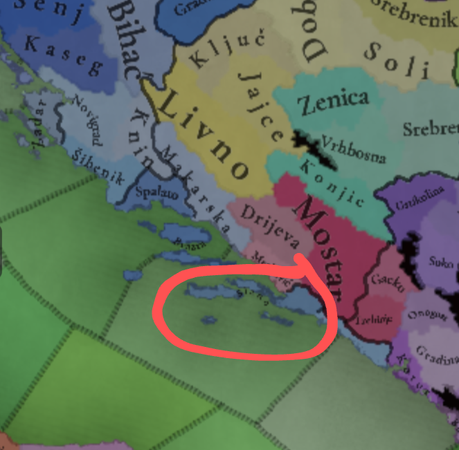
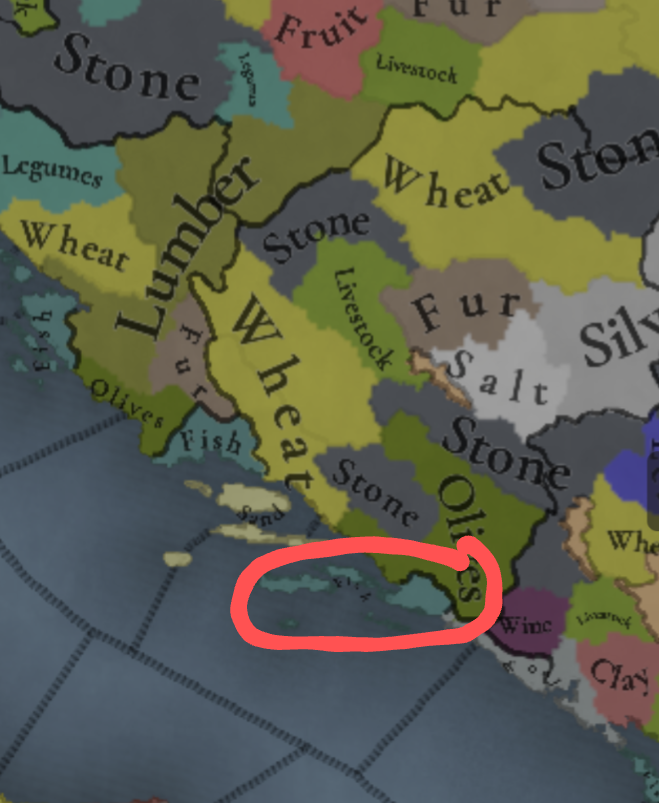
The island of Korčula ought to produce lumber rather than fish. Located off the Croatian coast, it was a strategically important source of timber for Venice.

The island is mentioned explicitly in "A History of Venice" by John Julius Norwich, Ch. 5:
Finally, the pine forests of Curzola and other islands guaranteed a virtually inexhaustible stock of timber for the Venetian shipyards.
1000012137.png

1000012136.png

And for what it's worth, the island's forestry is also mentioned on the Wikipedia page for Korčula:
Korčula had for years supplied the timber for the wooden walls of Venice, and had been a favourite station of her fleets.
 

Attachments

  • 1000012136.png
    1000012136.png
    456,4 KB · Views: 0
  • 7Like
Reactions:
I'd assume that "Based" is a compliment to applaud how fundamental their research on the subject is, but then some people laugh - which makes me somewhat confused.
Fun fact, that map even ignores the existence of székelys
 
  • 5Haha
Reactions:
So most of this is just naming semantics, but:
My original proposition of areas had "West Slovakia" to represent the Mining Towns and "East Slovakia" for Upper Hungary to avoid confusion with any imperialist/nationalist Hungarian sentiments. While the other terms might be more historically accurate, I chose to stick with two Slovakias, as the term "Slovak" dates back to the early part of PC's timeframe.
I also organized my areas further south roughly based on Ottoman eyalets, with Budin Eyalet roughly corresponding to Duna area, Egri Eyalet roughly corresponding to Great Plain, and Temesvar Eyalet roughly corresponding to Banat. I also chose to split Transylvania into a Szekely/German/Transylvanian Upper and a Hungarian/Ruthenian/Transylvanian Lower parts out of convenience. The Partium was a bit of an inconvenience, and I chose to group it with Great Plain for geographical reasons, but I'm open to the idea of having it as its own area stretching from Bihar to Bereg (perhaps leading to a combined Transylvania).
Honestly I do think that confusion with the modern term Felvidék should not really mean not using it, given that this was the name they were using for the area both officially and unofficially; it is sort of like not using the Roman Empire or Prussia because some people are weird about it, kind of. The only reason I think naming it after Upper Hungary might not work is because I don't really think Lower Hungary would work, but I don't have a strong opinion on the matter of naming.
Otherwise I'm of the opinion that Transylvania, Transdanubia and the Banat should be constant with their geographical boundaries, which are well-defined historically, and I think they should be as intact as possible, while the rest can have some freedom.
I don't however think that a Duna area makes much sense; it's not really a grouping a Hungarian would use, it feels a bit arbitrary to group Pest, Komárom-Esztergom and Nógrád together, I might prefer grouping Pest with the rest of the Danube-Tisza interfluve region instead. However I have no problem with one big "Alföld" area itself, stretching from Bodrog to Bihar and Szabolcs.

If I'm not mistaken, this Nitra/Captaincy of Mining towns region was known as "Lower Hungary" around the starting period the game.
It was, I also mentioned it briefly, but I do think the name sounds confusing out of context (given that it doesn't look any Lower than the Upper one)
 
  • 1Like
Reactions: