• We have updated our Community Code of Conduct. Please read through the new rules for the forum that are an integral part of Paradox Interactive’s User Agreement.

Tinto Maps #9 - 5th of July 2024 - Carpathia and the Balkans

Greetings, and welcome to another Tinto Maps! This week we will be taking a look at Carpathia and the Balkans! It will most likely be an interesting region to take a look at, with a lot of passion involved… So I’ll just make an initial friendly reminder to keep a civil discussion, as in the latest Tinto Maps, as that’s the easiest way for us to read and gather your feedback, and improve the region in a future iteration. And now, let’s start with the maps!

Countries:
Countries.png

Carpathia and the Balkans start in a very interesting situation. The Kingdom of Hungary probably stands as the most powerful country in 1337, but that only happened after the recovery of the royal power enforced by Charles I Robert of the House of Anjou, who reined in the powerful Hungarian nobility. To the south, the power that is on the rise is the Kingdom of Serbia, ruled by Stefan Uroš IV Dušan, who has set his eyes on his neighbors to expand his power. The Byzantine Empire, meanwhile, is in a difficult position, as internal struggles ended in Andronikos III being crowned sole emperor, at the cost of dividing the realm; both Serbia and Bulgaria have in the past pressed over the bordering lands, while the Ottomans have very recently conquered Nicomedia. The control over the Southern Balkans is also very fractioned, with a branch of the Anjou ruling over Albania, the Despotate of Epirus under the nominal rule of Byzantium as a vassal, Athens, Neopatria and Salona as vassals of the Aragonese Kings of Sicily, Anjou protectorates over Achaia and Naxos, and only nominal Byzantine control over Southern Morea. It’s also noticeable the presence of the Republics of Venice and Genoa, which control several outposts over the Adriatic and Aegean Seas. A final note: in previous maps, Moldavia was shown in the map, but we’ve removed it from it, and it will most likely spawn through a chain of events in the 1340s.

Dynasties:
Dynasties.png

The House of Anjou rules over Naples, Hungary, Albania, Achaia, and Cephalonia; they’re truly invested in their push for supremacy over the region. Apart from that, each country is ruled by different dynasties, except for Athens and Neopatria, ruled by the House of Aragón-Barcelona.

Locations:
Locations 1.png

Locations 2.png

Locations 3.png

Locations 4.png
This week we’re posting the general map of the region, along with some more detailed maps, that can be seen if you click on the spoiler button. A starting comment is that the location density of Hungary is noticeably not very high; the reason is that it was one of the first European maps that we made, and we based it upon the historical counties. Therefore, I’m already saying in advance that this will be an area that we want to give more density when we do the review of the region; any help regarding that is welcome. Apart from that, you may notice on the more detailed maps that Crete appears in one, while not being present in the previous one; because of the zooming, the island will appear next week along with Cyprus, but I wanted to make an early sneak peek of the locations, given that is possible with this closer zoom level. Apart from that, I’m also saying in advance that we will make an important review of the Aegean Islands, so do not take them as a reference for anything, please.

Provinces:
Provinces.png

Provinces! Nothing outstanding to be commented on here; as usual, we’re open to any feedback regarding them.

Terrain:
Climate.png

Topography.png

Vegetation.png

Terrain! The climate of the region is mostly divided between Continental and Mediterranean, with some warmer and some colder regions. Regarding the topography, the Carpathian mountains are famously important and strategic, while the Balkans are a quite hilly and mountainous region, which is also greatly covered by woods and forests.

Cultures:
Cultures.png

Here comes the fun part of the DD: The cultural division of the Balkans! A few comments:
  1. Hungary is full of different minorities. Transylvania, especially, is an interesting place: there we have a mix of ‘Hungarians’, ‘Transylvanians’ (which are the Romanian-speaking inhabitants of the region), ‘Transylvanian Germans’, and ‘Szekely’ people.
  2. We have divided the Southern Slavic-speaking region into their dialectal families of Slovene, Croatian, Bosnian, and Serbian.
  3. The Southern Balkans are mostly divided among Bulgarian, Albanian, and Greek cultures.
  4. We’re also portraying plenty of other cultures, such as Dalmatians, Aromanians, Sclavenes, Arvanites, Cumans, Jasz, or Ashkenazi and Romanyoti Jews.

Religions:
Religion.png

This one is also interesting. Apart from the divide between Western Catholicism and Eastern Orthodoxy, we have the Krstjani in Bosnia, Bogomils (the pink stripes both in Bosnia and Macedonia), and Paulicians in Thrace. The Jewish populations do not pass the threshold percentage to appear on the map, but there are plenty of communities across the region.

Raw Materials:
Raw Materials.png

The materials of the region. Something very noticeable is the richness of minerals, with plenty of Iron, Copper, Tin, Lead, Gold, and Silver. Specifically, Slovakia is very rich, and you definitely want more settlers to migrate to the region, and exploit its resources. The region is also very rich in agricultural resources, as you can see.

Markets:
Markets.png

The region is mostly divided among four markets: Venice, Pest, Ragusa and Constantinople.

Country and Location population:
Population 1.png

Population 2.png

Population 3.png

Population 4.png
Country and location population (which I’ve also sub-divided, and is under the Spoiler button).

And that’s all of today! I hope that you find the region interesting; we certainly think that it is. Next week we will go further south, and we will take a look at the Syrian Levant and Egypt. Cheers!
 
  • 193Like
  • 69Love
  • 7
  • 4
  • 3
  • 1Haha
Reactions:
I'd personally probably move Nógrád to Western Slovakia/Lower Hungary/Nitra, or maybe to Upper Hungary, mostly because of its hilly terrain, because of its local dialect being in the Palóc group, and its relatively high Slovak influence. I do feel like it belongs to the North, to be fair
I can see the argument for one of the Slovakias, but at the same time it wasn’t part of the Mining Towns and it wasn’t part of the Principality of Upper Hungary, so I’m iffy. I guess it would make sense to include it with the other two predominantly hilly Slovak areas, but only if the Duna area is axed.
 
  • 2Like
Reactions:
@Pavía @Johan The fact that this discussion is >60 pages long and shows no sign of stopping two weeks in makes me want to ask - is there a chance that we could have a pair of new, separate threads for Carpathia and Balkans? Or at least two iterations of and/or separate feedback threads instead of one? Both Carpathia and Balkans are worthy of a thorough discussion in their own right, but more pressingly there has been a lot of useful feedback in this thread, and it runs a genuine risk of it being lost in the noise.
 
Last edited:
  • 6
  • 1
Reactions:
Went through the Ottoman administrative divisions of the area to see what other locations could be added. Definitely not comprehensive by any means!
  • Crete:
    • Agios Pavlos -> Hora Sfakion/Sfakia
      • Late seat of an Ottoman Sanjak; notable for resistance to Ottoman rule
    • Elounda -> Ierapetra
      • Prosperous under Venetian rule

  • Mainland Greece:
    • Methoni -> Pylos/Navarino
      • More important during period? Ottoman Naval base
    • Kalamata -> split northern part into Leontari?
      • Briefly capital of Morea Sanjak (between Corinth and Mystras)
      • Unsure of resource
    • Loidoriki -> Lidoriki?
    • Demotica/Didymoteicho -> Split northwestern part into Ormenio/Çirmen
      • Seat of Sanjak of the same name from 1371-1829
      • Unsure of resource

  • Bosnia & Herzegovina:
    • Ustikolina -> Foča
      • Capital of the Sanjak of Herzegovina from 1470-1572
    • Srebrenik/Soli -> Split eastern part into Zvornik
      • Capital of Zvornik Sanjak
      • should produce Fruit or lumber
    • Zenica -> Split western part into Travnik
      • capital of Bosnia Eyalet from 1699-1832; fortified town
      • Livestock?
    • Kljuc/Doboj/Jajce -> add Vrbas (Banja Luka)
      • Capital of Bosnia Eyalet from 1553-1639
      • unsure of resource – maybe Lumber?

  • Kosovo:
    • Pristina -> Split northern part into Vushtrri
      • Capital of Viçitrina sanjak
      • Should produce Silver (Kapaonik mines)

  • Turkey:
    • Medea -> Vize/Bizyi
      • Capital of Vize Sanjak
Medea (Kiyikoy) was pretty important, historically, and I wouldn't delete it. Vize/Bizye is actually located on the border of the current Arcadiopolis and Medea location, but it would be a nice addition to have! It was still one of the remaining Byzantine fortress-towns in the region.

@purplephoton I think they'll be alright, they would've mentioned otherwise. I think they probably keep tabs or some notes or something. But I agree that there's lots of good feedback here! I'm loving it. Another thread could actually be counterproductive and create unnecessary noise. The developers might've anticipated a lot of comments in a Balkan/Carpathian-thread, too.
 
Last edited:
  • 2Like
Reactions:
@petarsc My man, that's an awesome suggestion! I was busy with my own correction/research of Montenegro, but you did it even better. The developers might already be pretty happy with the density of the Balkans, so that's something we should keep in mind (your suggestions are still solid, though). The Italy region only got 5 more locations, for example.

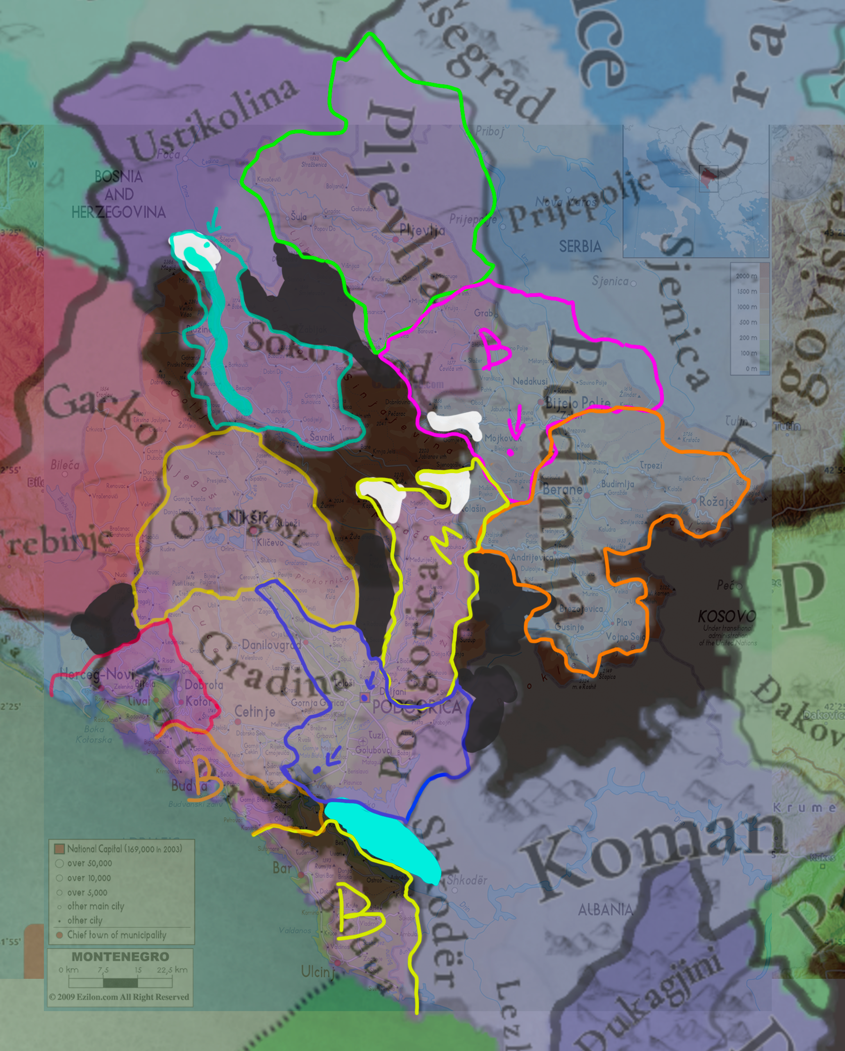
Here are my general comments on Montenegro:
View attachment 1164620
1: As you said so yourself, Gradina Martinic was already a ruin and not in use. The location was sparsely populated, but renaming it to Gornja Zeta would be a mistake, in my opinion. The developers aim to name locations after villages, towns, fortresses or cities, Gornja Zeta is neither of those. This may sound a bit odd, but I'd name it Cetinje already. I know that it's basically 150 years before its foundation, but some anachronisms aren't unheard of on the map. They're unavoidable, sometimes. And I doubt the developers want to create DHE's for every town that sprang up into existence during the game's timeframe.
2: Budua either gets renamed into Bar, or a new Budua location is carved out of Kotor and both Bar and Budua come into existence. That would be very nice for Venice, though. Depends on location-density, but with Lake Skadar being in the wrong location some space could be created for both of them.
3: Podgorica is located on the border between current Gradina and Podgorica, but I agree with your suggestion of renaming the location into either Podluzje or Zabljak Crnojevica (the latter has my preference) and redrawing the borders to indeed encompass all of these towns.

In short; I almost 100% agree with your suggestion, but I'd rename Gradina into Cetinje from the get-go, and Podgorica into Zabljak Crnojevica, with some rewritten borders to encompass the towns of Podgorica, Zabljak and Podluzje. Some slight anachronisms aren't odd to have in the Balkans, as long as they aren't 16th/17th/18th century towns. Your suggestions for other locations and some name-changes to the north are also very good!

Cheers!
If naming the province Cetinje would be possible then I would prefer adding Bjelopavlići to Podgorica location (naming it Žabljak Crnojevića if we are after fortress, town names), then Kuči would make sense to be part of Morača location as Podgorica would be large enough. This is better as then you can have Cetinje as mountains (or hills at least) and very sparsely populated, as it would be at the game start (also the naming of the location wouldn't stick out as there is nothing of note on that territory before the founding of Cetinje).

I also marked Žabljak, Brskovo, Soko and Podgorica, Bar and Budva are on the modern postions too, visible on the overlay.

Screenshot 2024-07-16 at 10.51..png
 
  • 2
  • 1
Reactions:
I can see the argument for one of the Slovakias, but at the same time it wasn’t part of the Mining Towns and it wasn’t part of the Principality of Upper Hungary, so I’m iffy. I guess it would make sense to include it with the other two predominantly hilly Slovak areas, but only if the Duna area is axed.
Fyi I do not think a Duna area should really exist, as it is not really a region denominator that I have ever seen Hungarians or historians use specifically for that region; it is sort of arbitrary to group Pest, Komárom and Esztergom as Danubian but not the other Danubian counties such as Győr, Fejér, Tolna etc. I could maybe see a Central Hungary or Danube-Tisza interfluve, including the provinces primarily between the two rivers, which could also include Nógrád and Heves, I guess.

Regardless, the burden of final decision is on Team Tinto afterall.
 
  • 3Like
  • 1
Reactions:
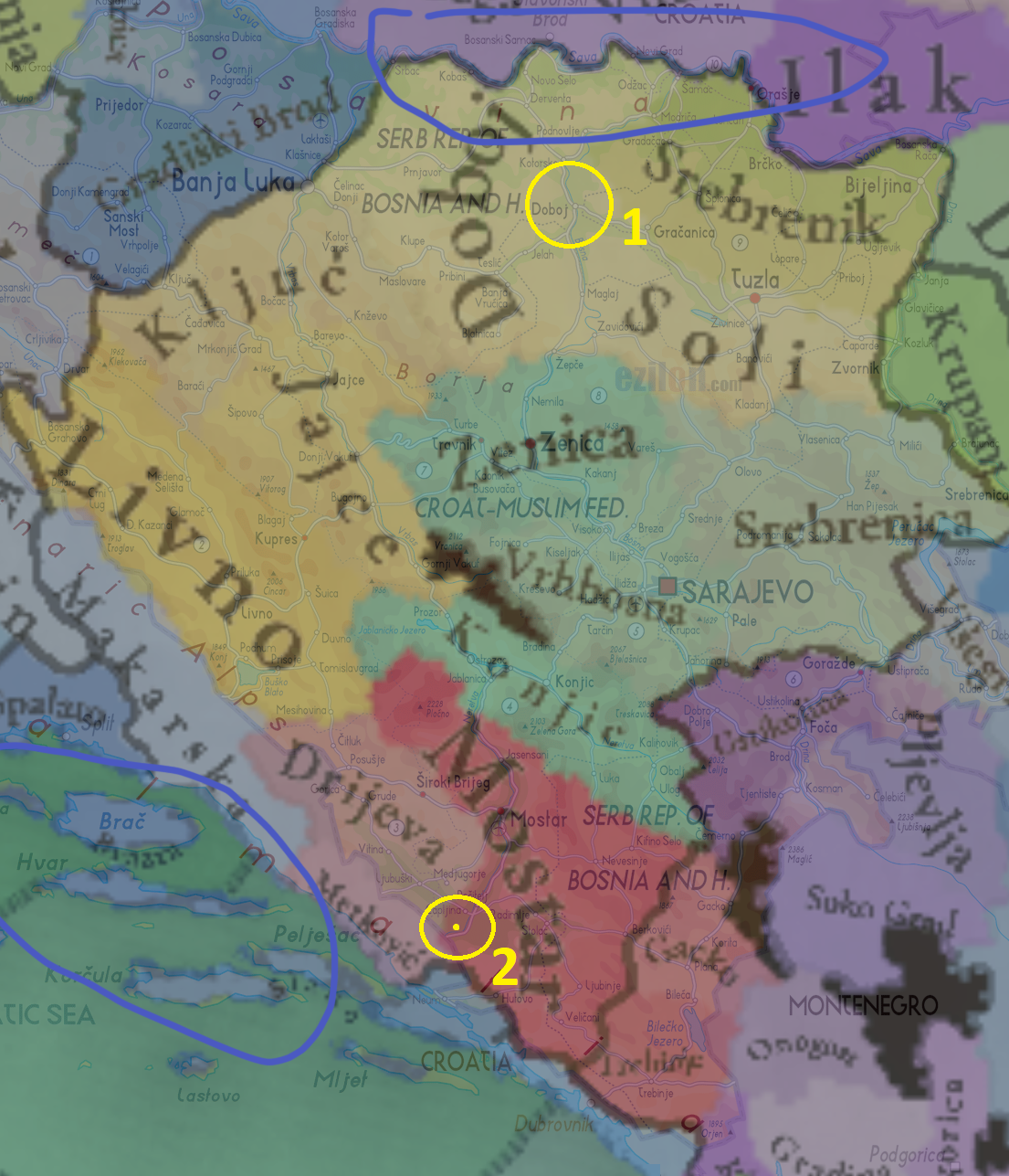
Thanks to the maps of @petarsc , I've found two very nitpicky points about Bosnia:
Overlay Bosnia.png


- Doboj is currently inside the horn of Soli's location.
- The old town of Drijeva, in what's today called Gabela which lays to the south of Capljina, is inside of Mostar's location.
- This also means that Metkovic is too close to the border of Drijeva (both towns were very close to each other), or might even be inside of it. So, some slight adjustments for Metkovic would also be in order.

As for the rest of Bosnia: I don't have that much to say. Even though some of Bosnia's locations are slightly anachronistic, all of them make a certain amount of sense. Additions could probably be proposed (and some already have been), and something can be said about a few of them, but I think Bosnia's current density is quite alright. The matter regarding culture and religion has also been spoken about by other people more knowledgeable on the matter, so I'm curious what the final results will be (Bosnian Church and culture probably more reserved for its inner parts and all that).

I guess that's it, for now. I don't have more Balkan regions to cover! Very curious how everything will turn out, especially Hungary which (as mentioned) needs a bigger overhaul than other regions. I get that it will probably take quite a few weeks, but still. Very much looking forward to it!
 
Last edited:
  • 3Like
  • 3
  • 1
Reactions:
Fyi I do not think a Duna area should really exist, as it is not really a region denominator that I have ever seen Hungarians or historians use specifically for that region; it is sort of arbitrary to group Pest, Komárom and Esztergom as Danubian but not the other Danubian counties such as Győr, Fejér, Tolna etc. I could maybe see a Central Hungary or Danube-Tisza interfluve, including the provinces primarily between the two rivers, which could also include Nógrád and Heves, I guess.

Regardless, the burden of final decision is on Team Tinto afterall.
How would you group Fejer, a Pest that includes Pilis, and Komarom-Esztergom, then, given that they cross the Danube?
 
  • 1Like
Reactions:
Albania and Epirus. Another headache, and not in terms of locations, but in terms of tags. Which isn't my specialty regarding this area, so I'll leave that to other people. So, before I go to my location-check, I'll start by making some comments about these tags:
- The area was basically under control of either the Angevins, the Byzantine Empire or the Despotate of Epirus. Some areas under direct control, like Durrës and Bouthrotón (both Angevin), and a lot only nominal. Bouthrotón should be a bit smaller, as it was an exclave (@DOURIOS mentioned this as well).
- That's where the fun begins: Which nominal areas where controlled by which of these 3 tags? Or, if the developers feel particularly brave: Under which Albanian clan/family?
- One way or another, the current setup doesn't do the area justice yet. There need to be some tweaks. For example: The Despotate probably didn't have nominal control over that much of Albania (unless I'm just very mistaken). And the Angevins probably didn't have nominal control over such a large area, either.
- Some players would really like the Albanian clans to have more prominence on the map. Clans/families like the Thopia and the Muzaka. The question then however is, which areas did they actually control? And should they be under vassalage or not?
- I'll leave the tag-discussion at that... So, if anyone got some good sources/maps on this matter, that'd be appreciated.
View attachment 1164215

But onwards to my 'specialty'! Location-checks.
Here we go:
1: Árta is located somewhere around that yellow dot and might be slightly located within the Préveza location. I'd rewrite those borders, just in case.
2: Same for Kleisoúra, basically.
3 and 4: Dukagjini is a small village, but the political center of the Dukagjini family was actually located at Lezhë (before it was handed over to the Venetians). Even though Albania's towns slowly started development into bigger urban centers, none of the maps I've seen of both Medieval Albania as well as Serbia depict this area. It seems as if this village has always been that; Small.
Some maps from the 14th/15th centuries:
View attachment 1164218
View attachment 1164219
View attachment 1164220View attachment 1164221
But! Which town was actually located within this location's vicinity? Peshkopi/Peshkopia (https://en.wikipedia.org/wiki/Peshkopi it was inhabited in the 14th century, but started properly developing during Ottoman times, like a lot of the Albanian towns). A worty addition, but one which requires some small changes to the borders of this location as well as Debar's and Krujë's.


For Dukagjini, there is also a Dukagjin village in Kukës County and the Dukagjini Highlands, with which Koman has some overlap. However, the map location seems to correspond to the Mirdita region, a Catholic Albanian stronghold. The Mirditors seem to have some relation to the Dukagjini family as well.

Here is a map that shows the Bajrak of Mirdita: https://commons.wikimedia.org/wiki/File:Albanian_Pashaliks,_1815-1821.png
 
Last edited:
  • 1Like
Reactions:
How would you group Fejer, a Pest that includes Pilis, and Komarom-Esztergom, then, given that they cross the Danube?
I'd group Fejér and Komárom-Esztergom as Transdanubia, because most of their territory is in Transdanubia, and Pest to Central Hungary or whichever area occupies the lands between the two rivers, to be fair
 
  • 3
  • 1
Reactions:
Speaking of Catholics in Bosnia, there were and still are many Franciscan monasteries in Bosnia that were built during this time period. Therefore, I wouldn't say the Bosnian Church was as much of a majority as depicted on the map. I would at least show a Catholic minority in every Bosnian province, not just in Srebrenica.

Furthermore, I would also like to see a small Vlach minority spread across Bosnia, Serbia, Dalmatia, and maybe even Slavonia (the area of the Papuk mountain). The Vlachs lived a pastoral lifestyle, traveling seasonally from the mountains to the plains, and they gave their names to mountains in Bosnia such as Vlašić, Romanija, and Kozara. Even today, people still call each other "Vlaji" as an insult in Bosnia and Dalmatia, as far as I know.

Lastly, There should be a different culture than Bosnian in the provinces of Herzegovina. If you ask a Herzegovinian today, they will tell you they are not Bosnian; they are Herzegovinian.
 
  • 3Like
  • 3
  • 1
Reactions:
An added note which I also want to point out but which doesn't really fit into the main post: I find it very unlikely that the Kristjani would exist in coastal Croatia and what is today coastal Bosnia

The area had been part of a series of realms (Venice, Croatia and Hungary) which maintained heavy contact with the Italian and Dalmatian city states, Italy proper and the rest of the Croatian highlands which were predominately catholic. The Bosnian Church was unique because it existed in isolation from the mainstream catholic sphere on the coast and the west, and the orthodox sphere in the north and east.

I don't have any books or sources on this one in particular and it's just something that I find very strange to say the least. You'd expect the Catholic influence to penetrate along with the well documented cultural influence of Italy and Croatia (which I elaborated on in more detail before), and not have the area be apparently isolated from the rest of the Balkans? Would be interesting to know where this comes from and if there's some documentation regarding that, because I am genuinely blank. :)
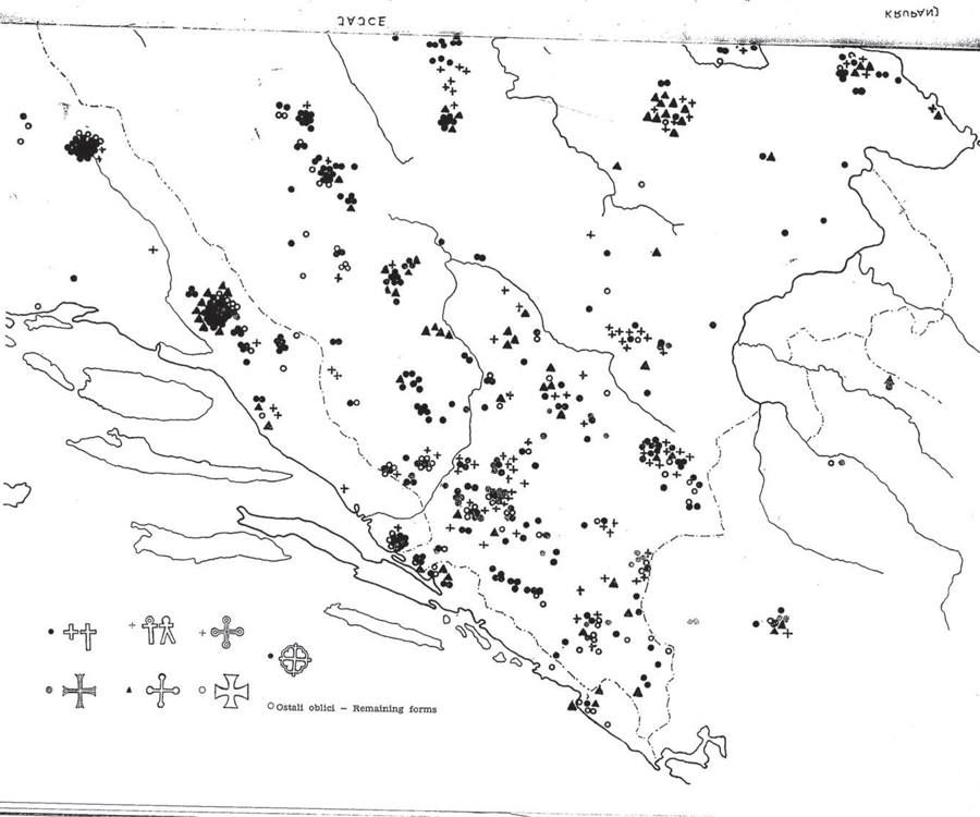
My guess is that they perhaps had a look at something like the map of known necropoli of Stecci, which are tombstones associated (but not exclusively tied to) the Bosnian Church. However, if a location has a necropolis of these tombstones then it can be expected to have had significant influence from the medieval Bosnian culture/political entity, and thus potentially the religion too. I don't necessarily agree that everywhere where Stecci are found is a guaranteed presence of Bosnian Church adherents, since each necropolis should be examined to see if it has more Bosnian Church, Catholic, or Orthodox symbols inscribed on them, and also how old it is.

This kind of map might be of interest to some though, as it shows the kind of crosses found on various Stecci in and around Bosnia. I'm no expert but it seems to me there is quite some difference between the symbols in central/southern Bosnia vs. those in modern-day Croatia, so this could show something about the Bosnian Church presence.
1721338015236.png
 
  • 1Like
Reactions:
Speaking of Catholics in Bosnia, there were and still are many Franciscan monasteries in Bosnia that were built during this time period. Therefore, I wouldn't say the Bosnian Church was as much of a majority as depicted on the map. I would at least show a Catholic minority in every Bosnian province, not just in Srebrenica.

Furthermore, I would also like to see a small Vlach minority spread across Bosnia, Serbia, Dalmatia, and maybe even Slavonia (the area of the Papuk mountain). The Vlachs lived a pastoral lifestyle, traveling seasonally from the mountains to the plains, and they gave their names to mountains in Bosnia such as Vlašić, Romanija, and Kozara. Even today, people still call each other "Vlaji" as an insult in Bosnia and Dalmatia, as far as I know.

Lastly, There should be a different culture than Bosnian in the provinces of Herzegovina. If you ask a Herzegovinian today, they will tell you they are not Bosnian; they are Herzegovinian.
Agree with all of this except the last point - modern Herzegovinian culture is definitely different than it was in 1337, and I can imagine the differences are much starker now than back then. I think it's best to just leave the cultural diversity in Herzegovina in 1337 as between Catholic/Krstjani Bosnians and Orthodox Serbs.
 
  • 4Like
Reactions:
After many days I have finally finished with the Montenegrin, Epirus and (mostly) Albanian regions. All in all 9 locations have been split, five border changes have been made and I also added the names of the locations (the locations that I worked on) under the respective culture that they start in 1337.


I will first start with the political map and it's changes (below are the official map from paradox and my map with the needed corrections).
View attachment 1164453
View attachment 1164500
The changes:

-Albania shouldn't start as a state (as they didn't exist at the time, although the Neapolitan Durres claimed themselves to be) but rather a formable nation to be able to form by the Albanian principalities of the region if they control certain locations for example (Kruje, Berat, Durres, Dukagjini and Lezhe).The Thopia principality should start in the place of Albania with some location changes, the location of Durres under Neapolitan control, Dukagjini under Serbian control and the Elbasan location under the Arianiti family who they in turn are under Byzantine suzerainty.

Thopia principality
View attachment 1164458
View attachment 1164459
(I also added this map of the rivers in Albania, to better understand where the borders of the principalities and locations should be)
View attachment 1164460
The Arianiti principality history before 1337 and it's rough borders around Elbasan.
View attachment 1164461
View attachment 1164462


-The Despotate of Epirus (Who at the start date was in the process of becoming a province of Byzantium) northern border should be Avlona with the Berat and Kavaje locations instead be held by the Mazuka family who they too like the Arianiti were under nominal Byzantine control (as they styled themselves with Byzantine titles pursuing careers in the Byzantines state as well as Andronikos the third putting down a revolt in 1337 by Albanians in the area).

By late 1337 to 1338 the Despotate of Epirus was peacefully incorporated into The Byzantine Empire thanks to the efforts of Emperor Andronikos the third.
View attachment 1164465

The Mazuka family's history before 1337 and it's shifting loyalties.
View attachment 1164468
The failed revolt by Mazuka in 1337
View attachment 1164467


-The Kingdom of Serbia should also control the locations of Dukagjini, Pogradec, Pogradec is one of the new locations that I added (I would show later don't worry) and Florina.

View attachment 1164469
Source
View attachment 1164470

-The kingdom of Naples at 1337 should controll the port of Durres and it's immediate areas (I have taken away half of the location of Durres as it was very big and gave it to a new location Petrele). The island of Corfu with the Bouthroton fortress should be part of Naples as well, (Bouthroton as a location should be split, as Bouthroton itself was just a fortress with a small settlement that was slowly disappearing, its location is right across Corfu and it's purpose was to warn and protect the island from invading army's)

View attachment 1164475
Corfu
View attachment 1164478
Bouthroton (Butrint)
View attachment 1164479
This is it for the political spectrum of the region.


I would now focus on the changes in location borders and breakup of certain large locations, as you can see they are quite a few...
View attachment 1164499
View attachment 1164481
(The original map side by side for comparing differences).

Alright from north to south.

- The Budimlja location has changed to Brskovo as it was an already existing town in the 14th century while Budimlja wouldn't be mentioned until the 16th century
View attachment 1164482
I have also split the original Budimlja location in two as I believe it is quite big, the northern part is unfortunately quite devoid of written settlements in 1337 with the exception of the Kumanica monastery (if anyone knows of a better location name please inform me). While the light green stripes are to be taken of Podgorica location and be given to Brskovo as the town is right at the border between the two so in order to be more clear cutted I assigned that area to Brskovo.


-The koman location has been split in two new locations, while the yellow stripes are to be given to the Dukagjini location in order for the border to better reflect the drin river.
View attachment 1164485


-The Dibra location has been split in two, since the new location Presolengrad was in written records from when Bulgaria controlled the region in the 11th century! (thus it's Slavic name).
View attachment 1164486
While the red striped area is to be taken of the Kruje location and be given to Presolengrad in order to better reflect Thopia's borders as they were between the Mat and Skhumbin rivers.
View attachment 1164493


-The Kruje location too has been split with Petrele taking the southern part of the location as it was an fortified location in 1337. The orange area of stripes should be taken of Durres and given to Petrele as Durres an Angevin possession only controlled the city and immediate surroundings.
View attachment 1164490


-The Durres location as I said above should give half of it's southern area to Petrele as it certainly didn't control that much south and inlands.
View attachment 1164494
For reference (notice how even my reduced location is still big compared to what was actually controlled).


-The location of Berat has been split in three as there are a number of important settlements in the location area of Berat. Fier which was used for trade by the venetian merchants.
View attachment 1164495
While the Gramsh location seems to have been under the Arianiti family.
View attachment 1164498


-The Devol location has been split in two with the important Pogradec town being added.
View attachment 1164503

-The Vlore location has been split as well with the town of Himara being added in the south.
View attachment 1164504


- I have decided to split the Kelcyre location as it seems quite big for only one location, adding Konitsa which it was first mentioned in 1380 as a fortified location so quite important and it probably existed in 1337.
View attachment 1164505


-And lastly the Bouthroton location which is shown to have a ridiculously big area. The Bouthroton fortress was built in order to keep the island of Corfu safe from raiders and invading army's (it's nicknamed the eyes and ears of Corfu for a reason after all).
View attachment 1164509
What the Bouthroton really should be as a location.

However since it will be a very small location to add I think it will be best for Bouthroton to be included in the location of Corfu as one (the area of the light yellow stripes), for the fortress never truly fell until the end of the 18th century when french forces of Napoleon took the Corfu and the Albanians seized the opportunity and took Bouthroton (you can see how interconnected Corfu and Bouthroton were).
So instead of Bouthroton the location name should be Agioi Saranda as there was a local monastery in the area (even thought the town seems to be abandoned at the time).
View attachment 1164516

So that's it then, this took quite a while to make but I think in the end it was worth it!


Ps: my thanks to @Mingmung for inspiring me to finish it sooner rather than later.
Can you make your images a bit larger? They're too small to read... ;)
 
Better to be too big and easy to see instead of having to poke your eyes out in order to read a name.
P.s
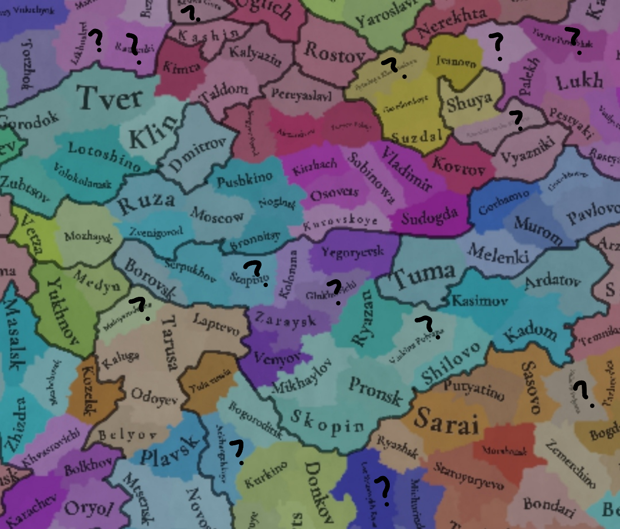
The one east from Serpukhov is Stupino.
In NW corner, my reading based on modern maps: Torzhok - Likhoslavl - Ramenki (Rameshki ?) - Kashin - Kesova Gora
 
Last edited:
  • 1Like
Reactions:
The one east from Serpukhov is Stupino.
In NW corner, my reading based on modern maps: Torzhok - Likhoslavl - Ramenki (Rameshki ?) - Kashin - Kesova Gora
This is the Balkan/Carpathian thread guys :p
 
  • 2Like
Reactions:
The one east from Serpukhov is Stupino.
In NW corner, my reading based on modern maps: Torzhok - Likhoslavl - Ramenki (Rameshki ?) - Kashin - Kesova Gora
Thanks the one am really trying to read is the one bordering Ryazan northwest, I really wish Russia was given more detailed maps it's really frustrating trying to pick one by one
 
I'd group Fejér and Komárom-Esztergom as Transdanubia, because most of their territory is in Transdanubia, and Pest to Central Hungary or whichever area occupies the lands between the two rivers, to be fair
Alternatively, Fejer proper (without Solt) can be grouped together with Pilis for pretty provincial borders, I guess… in either case though, Transdanubia isn’t going to be a perfect match.
 
  • 1
Reactions: