• We have updated our Community Code of Conduct. Please read through the new rules for the forum that are an integral part of Paradox Interactive’s User Agreement.

Tinto Maps #9 - 5th of July 2024 - Carpathia and the Balkans

Greetings, and welcome to another Tinto Maps! This week we will be taking a look at Carpathia and the Balkans! It will most likely be an interesting region to take a look at, with a lot of passion involved… So I’ll just make an initial friendly reminder to keep a civil discussion, as in the latest Tinto Maps, as that’s the easiest way for us to read and gather your feedback, and improve the region in a future iteration. And now, let’s start with the maps!

Countries:
Countries.png

Carpathia and the Balkans start in a very interesting situation. The Kingdom of Hungary probably stands as the most powerful country in 1337, but that only happened after the recovery of the royal power enforced by Charles I Robert of the House of Anjou, who reined in the powerful Hungarian nobility. To the south, the power that is on the rise is the Kingdom of Serbia, ruled by Stefan Uroš IV Dušan, who has set his eyes on his neighbors to expand his power. The Byzantine Empire, meanwhile, is in a difficult position, as internal struggles ended in Andronikos III being crowned sole emperor, at the cost of dividing the realm; both Serbia and Bulgaria have in the past pressed over the bordering lands, while the Ottomans have very recently conquered Nicomedia. The control over the Southern Balkans is also very fractioned, with a branch of the Anjou ruling over Albania, the Despotate of Epirus under the nominal rule of Byzantium as a vassal, Athens, Neopatria and Salona as vassals of the Aragonese Kings of Sicily, Anjou protectorates over Achaia and Naxos, and only nominal Byzantine control over Southern Morea. It’s also noticeable the presence of the Republics of Venice and Genoa, which control several outposts over the Adriatic and Aegean Seas. A final note: in previous maps, Moldavia was shown in the map, but we’ve removed it from it, and it will most likely spawn through a chain of events in the 1340s.

Dynasties:
Dynasties.png

The House of Anjou rules over Naples, Hungary, Albania, Achaia, and Cephalonia; they’re truly invested in their push for supremacy over the region. Apart from that, each country is ruled by different dynasties, except for Athens and Neopatria, ruled by the House of Aragón-Barcelona.

Locations:
Locations 1.png

Locations 2.png

Locations 3.png

Locations 4.png
This week we’re posting the general map of the region, along with some more detailed maps, that can be seen if you click on the spoiler button. A starting comment is that the location density of Hungary is noticeably not very high; the reason is that it was one of the first European maps that we made, and we based it upon the historical counties. Therefore, I’m already saying in advance that this will be an area that we want to give more density when we do the review of the region; any help regarding that is welcome. Apart from that, you may notice on the more detailed maps that Crete appears in one, while not being present in the previous one; because of the zooming, the island will appear next week along with Cyprus, but I wanted to make an early sneak peek of the locations, given that is possible with this closer zoom level. Apart from that, I’m also saying in advance that we will make an important review of the Aegean Islands, so do not take them as a reference for anything, please.

Provinces:
Provinces.png

Provinces! Nothing outstanding to be commented on here; as usual, we’re open to any feedback regarding them.

Terrain:
Climate.png

Topography.png

Vegetation.png

Terrain! The climate of the region is mostly divided between Continental and Mediterranean, with some warmer and some colder regions. Regarding the topography, the Carpathian mountains are famously important and strategic, while the Balkans are a quite hilly and mountainous region, which is also greatly covered by woods and forests.

Cultures:
Cultures.png

Here comes the fun part of the DD: The cultural division of the Balkans! A few comments:
  1. Hungary is full of different minorities. Transylvania, especially, is an interesting place: there we have a mix of ‘Hungarians’, ‘Transylvanians’ (which are the Romanian-speaking inhabitants of the region), ‘Transylvanian Germans’, and ‘Szekely’ people.
  2. We have divided the Southern Slavic-speaking region into their dialectal families of Slovene, Croatian, Bosnian, and Serbian.
  3. The Southern Balkans are mostly divided among Bulgarian, Albanian, and Greek cultures.
  4. We’re also portraying plenty of other cultures, such as Dalmatians, Aromanians, Sclavenes, Arvanites, Cumans, Jasz, or Ashkenazi and Romanyoti Jews.

Religions:
Religion.png

This one is also interesting. Apart from the divide between Western Catholicism and Eastern Orthodoxy, we have the Krstjani in Bosnia, Bogomils (the pink stripes both in Bosnia and Macedonia), and Paulicians in Thrace. The Jewish populations do not pass the threshold percentage to appear on the map, but there are plenty of communities across the region.

Raw Materials:
Raw Materials.png

The materials of the region. Something very noticeable is the richness of minerals, with plenty of Iron, Copper, Tin, Lead, Gold, and Silver. Specifically, Slovakia is very rich, and you definitely want more settlers to migrate to the region, and exploit its resources. The region is also very rich in agricultural resources, as you can see.

Markets:
Markets.png

The region is mostly divided among four markets: Venice, Pest, Ragusa and Constantinople.

Country and Location population:
Population 1.png

Population 2.png

Population 3.png

Population 4.png
Country and location population (which I’ve also sub-divided, and is under the Spoiler button).

And that’s all of today! I hope that you find the region interesting; we certainly think that it is. Next week we will go further south, and we will take a look at the Syrian Levant and Egypt. Cheers!
 
  • 193Like
  • 69Love
  • 7
  • 4
  • 3
  • 1Haha
Reactions:
Alternatively, Fejer proper (without Solt) can be grouped together with Pilis for pretty provincial borders, I guess… in either case though, Transdanubia isn’t going to be a perfect match.
Yeah, it will never be 100% perfect, but it's probably close enough. Imo the main goal is to make provinces follow historical county borders as close as possible.

As long as it is not a single enormous area but at least 4-8 smaller ones I'm content
 
  • 1Like
Reactions:
Alternatively, Fejer proper (without Solt) can be grouped together with Pilis for pretty provincial borders, I guess… in either case though, Transdanubia isn’t going to be a perfect match.
Transdanubia is a super anachronistic division tbh. I would suggest some alternate approach for areas. Diocese groupings or minting chambers would be a better fit, imo.
 
  • 1
Reactions:
Transdanubia is a super anachronistic division tbh. I would suggest some alternate approach for areas. Diocese groupings or minting chambers would be a better fit, imo.
Areas are first and foremost geographical areas, and the basis for exploration for example; archdioceses and mining chambers are way too arbitrary for that.

Besides, Transdanubia is not a super anachronistic division, not sure why you are saying that; it really is mostly just a geographical area, I don't think there is anything anachronistic about it
 
  • 2
Reactions:
Alright, this will be a long one. It started out as a look at the mineral-based tradegoods in Transylvania and parts of the Maramaros-region, but it will also cover Moldavia and Wallachia in a follow-up post. Other things besides mineral-based tradegoods might get mentioned, too. Keep in mind, some stuff has already been covered in some of my earlier comments in this thread, and some bits may have been mentioned by others, too. This is kind of the more elaborate take on the matter.

In short, the list of changes I'd make to Transylvania and Maramaros (I'm mostly using Hungarian location-names):
- Körösbánya: Wheat -> Gold
- Aranyosbánya: Livestock -> Gold
- Dés: Stone -> Salt
- Szék: Stone -> Salt
- Nagyszeben: Iron -> Salt
- Belényes (Beius): Livestock -> Iron (recommended)/Copper (maybe)
- Bánffyhunyad: Salt -> Fruit (or Livestock/Wool, otherwise)
- Gyulafehérvár: Iron -> Gold (not recommended)/Wine/Livestock
- Felvinc: Lumber -> Iron (recommended)/Salt (not recommended)
- Marosvásárhely and/or Székelyudvarhely: Wool/Livestock -> Horses
- Sepsiszentgyörgy: Copper -> Lumber/Livestock
- Csíksomlyó (which could be renamed to Csíkszereda) or Gyergyószentmiklos, depending on the location of Balánbánya which had iron- and coppermines: Stone -> Copper (recommended, for variety's sake, end of 18th century onward)/Iron (17th century onward)
- Either Hateg or Déva (depends on the location of Hunyad): Stone/Horses -> Iron
- Nagyszölös: Lumber -> Wine
- Possible but not recommended; Marosvásárhely: Wool -> Salt
- Possible but not recommended; Bihar: Lumber -> Iron
- Tradegood for a possible new location entirely; Máramarossziget: Salt

Sources/explanations:
- A lot of the towns/mines can be found on Wikipedia, but they can be cross-referenced (and should be, where necessary). I will also list some articles further down this post.
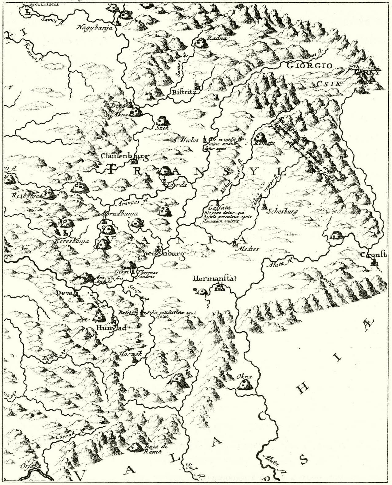
- Most of the mines can coincidentally be found on this 18th century (around 1726) map:
Transylvania mines map.jpg

- Most of the current mineral-tradegoods of Transylvania are indeed correctly placed; The Felsöbánya, Láposbánya and Kísbánya gold and silver mines (in the Baia Mare location), the Torda salt mine in the Torda location, the silver mines of Óradna (Radna location), and the salt deposits of Cojocna within the Koloszvár location.
- Koloszvár also had an iron mine in its vicinity, at Capusu Mic, but its salt-deposits are far more important to represent. So, we'll keep it that way for Koloszvár.
- The Wikipedia-pages (translated from either Romanian, Hungarian or German) for Körösbánya (as well as other mining towns within its boundaries: Nagybánya, Caraci and Tebea) and Aranyosbánya/Baia de Aries (and its other mines within its location like Abrudbánya and mines at Rosia Montana) are more than sufficient to justify a Gold tradegood there. Both mining areas were productive in the 14th century. Their names are also on the Transylvanian map posted above.
- There was a very important saltmine not even a stone throw's away from Szék; The Sic/Szék salt-mines. Coincidentally also visible on the map of the mines in this region. A quick Wikipedia search does the rest; Salt mines may have been there since Roman times, even.
- Same for Dej/Désakna, with the salt mine of Ocna Dejului. It has been documented from the 13th century onward.
- I couldn't find anything about the Iron-tradegood the Sibiu/Nagyszeben location currently has, but there was a significant salt deposit there. The saltpans of Ocna Sibiului: https://ro.wikipedia.org/wiki/Ocna_Sibiului. I'd suggest changing it to that.
- Some information on the history of mining in Romania, which mentions a lot of the aforementioned historical salt-mines (in Romanian, but Google Translate carries the day): https://www.agir.ro/univers-inginer...-zacamintelor-de-sare-din-romania-i_4747.html
- Belényes/Beius seems to include the village of Vascau/Vaskóho, which literally means 'iron-oven'. The region was known for its ironworks, as well as its iron-rich hills and this village has been mentioned since at least the first half of the 16th century. As I said, I think this area is included within the current Beius-location, but such things should always be checked. I don't have the same map-projections as the devs. It would be a good addition, especially if the Iron-tradegood is removed from other locations in Transylvania because of the rich saltdeposits taking precedence over other resources. Beius itself may have had a few iron deposits in its surroundings, too. The coppermine of Rézbánya (also known as Baita, and located on the map of the Transylvanian mines) also seems to be within this location, or maybe within Körösbánya (which, as mentioned earlier, should have the Gold-tradegood). Rézbánya was mentioned around the 16th century, so the Copper-tradegood could be an option for this location, too. I'd personally still opt for the Iron-tradegood though, as iron deposits were more widespread in this region.
- Another site was at Bertény/Birtiu, but this site might actually be inside the Bihar location, which is too big to be dedicated to Iron. Livestock and Lumber are more important in that location.
- Yes, Bánffyhunyad was a stop on the Transylvanian salt-road, but it doesn't seem to have any of the major historical saltworks/-mines/-pans within its borders. I'd suggest changing the tradegood to something different, like Livestock or Fruit (the region is known for its berries). The other locations got plenty of salt now, if the suggestion is taken to heart. So, it wouldn't even be a net loss.
- Gyulafehérvár, just like Nagyszeben, doesn't seem to have iron mines within its vicinity. Gold was found here, though, at the Almasu Mare and Zlatna gold mines. The problem is that this might be a bit 'overpowered' for the Kingdom of Hungary. I'd opt for a different tradegood altogether, to balance things out a bit. Something agriculture related, like Wine (the location had plenty of vineyards) or Livestock, for example.
- Sepsiszentgyörgy currently has the Copper-tradegood, but there don't seem to be any copper-mines of note within its vicinity. Either Gyergyószentmiklos or Csíksomlyó seems to have the Balan/Bálanbánya copper-mine within its location-boundaries, though. They should be in Csíksomlyó, historically-speaking, though. The location needs to be double-checked, and possibly redrawn. This mine could go both ways; It was an iron-mine in the 17th century and became a copper-mine in the late 18th century/early 19th century. This might be quite the anachronism (it's pretty late in the game's timeframe). The thing is, Transylvania has quite the copper reserves, only most of it is gained from mines with other resources, like gold. Such commodities can take precedence when it comes to designating one single tradegood to a location. So, giving Copper to Gyergyószentmiklos could create the only Copper-location in Transylvania (which would suffice). Or it could be given another Iron-tradegood. Or something else, entirely, because of it being located within Székely lands (which still lacks a tradegood like Sturdy Grains and Horses).
- Either Hateg or Déva seems to include the iron-mines around Hunyad (at Teliucu and Ghelari). This region was historically very important for Transylvanian iron production. So, whichever fits the location the best. I think EU4 had an Iron-tradegood located within Hunyad, too.
- Nagyszölös should be no discussion, at all! It literally means 'big orchard'. It was known for its wines, and it would also give Transylvania/Maramaros at least one location with the Wine-tradegood. Which is befitting for this region, as Transylvania produces some quality wines.
- Felvinc (Unirea) seems to have the Rimetea (Torockó) iron-mines within its location, which should not be confused with Remete/Gyergyóremete of Harghita county to the east (coincidentally also on the map of the Transylvanian mining towns, but not that noteworthy). It had a mix of Székely and Transylvanian Saxon inhabitants, and was one of the first German mining towns of Transylvania. If it's not within the Felvinc-location, then it definitely should be. So, the Lumber-tradegood should be replaced with Iron. Felvinc also seems to host the Ocna Mures/Marosújvar salt-mines, but those were opened at the back-end of the game's timeframe (end of the 18th century), the Torockó iron-mines should take precedent.
- Either Marosvásárhely and/or Székelyudvarhely should have the Horses-tradegood. The Székely-people were renown for their horse- and cattle-breeding (the Hucul pony, for example), but currently don't have any Horse-tradegoods. With the exception of the mining-locations, there should be a variety of Wool-, Livestock- and Horses-producing locations in the Székely lands. Lumber and Stone could be kept in other Transylvanian locations.
- Marosvásárhely could in theory also get the Salt-tradegood, because of the Praid salt mines (proper exploitation started around the 18th century, and the mines are seemingly within the location-borders of Marosvásárhely, but not sure). I wouldn't recommend its addition, though. The Székely lands should mostly be filled up by wool-, livestock-, lumber-tradegoods, maybe sturdy grains, etc. And Transylvania seems to have plenty of salt (which is historically correct) without this one addition. So, it could stay as it is: Wool.
- Máramarossziget, if added (and it should be!), should produce the Salt-tradegood, as well. This is because of the Solotyvno salt mine (in use since at least the 14th century) as well as the Rónaszék/Costiu mine (in use since at least the 15th century). Both are a stone throw's away from the town itself.
- This article has some general information on the Medieval mines (basically a lot of the mentioned names and what they produced) on page 72: https://intapi.sciendo.com/pdf/10.2478/minrv-2023-0031 It may clarify my points a bit more clearly.

Lots of valuable tradegoods, and lots of salt, too! But it's only befitting for this region. Next up will be both Wallachia and Moldavia.

EDIT: Added a suggestion for Felvinc and other Székely locations in general. Also made a note about the copper/iron-mines actually being in Csíksomlyó (which could be renamed into Csíkszereda), because of the location of Bálanbánya.
 
Last edited:
  • 5
  • 3Like
  • 2Love
Reactions:
Areas are first and foremost geographical areas, and the basis for exploration for example; archdioceses and mining chambers are way too arbitrary for that.

Besides, Transdanubia is not a super anachronistic division, not sure why you are saying that; it really is mostly just a geographical area, I don't think there is anything anachronistic about it
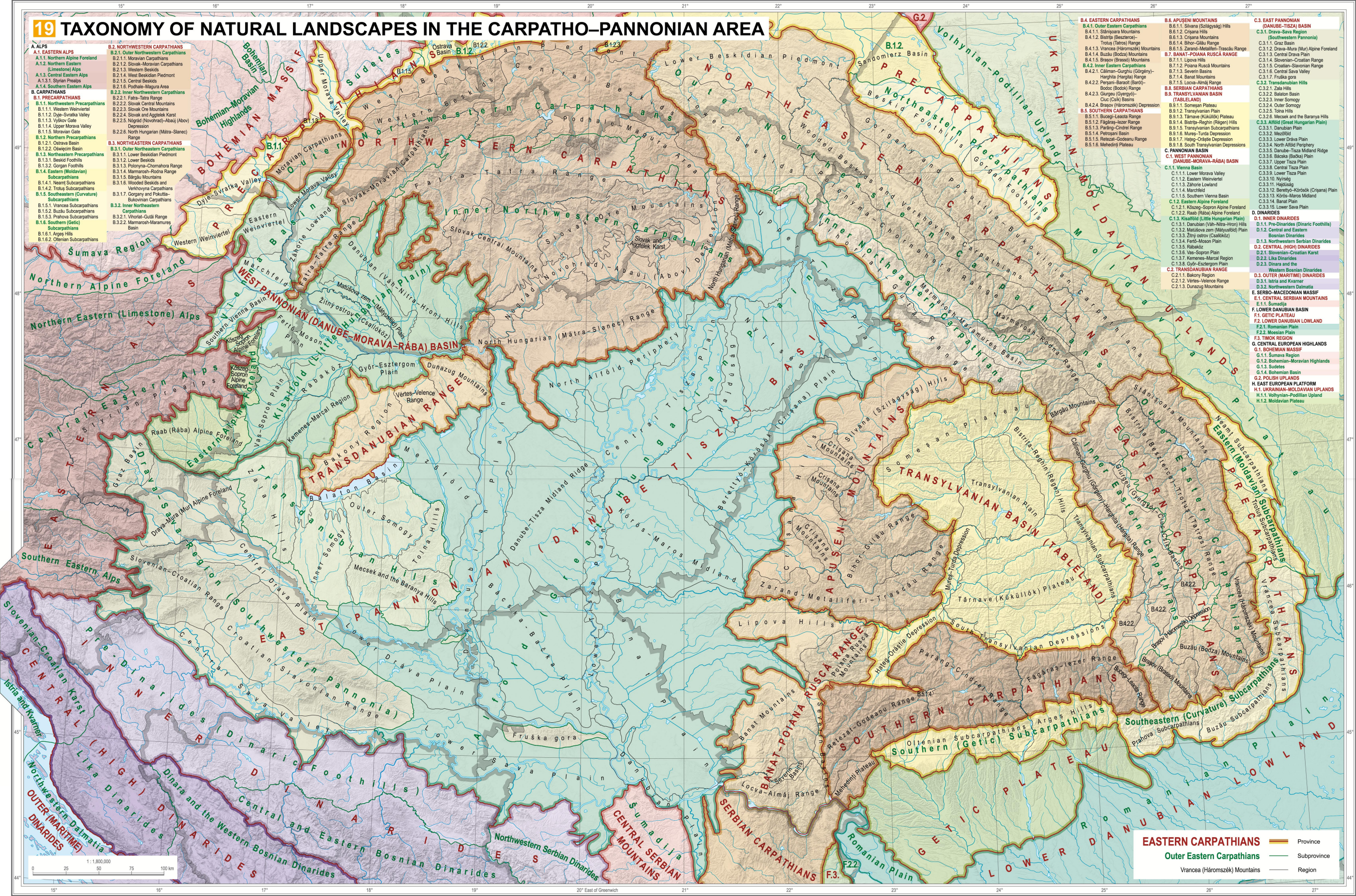
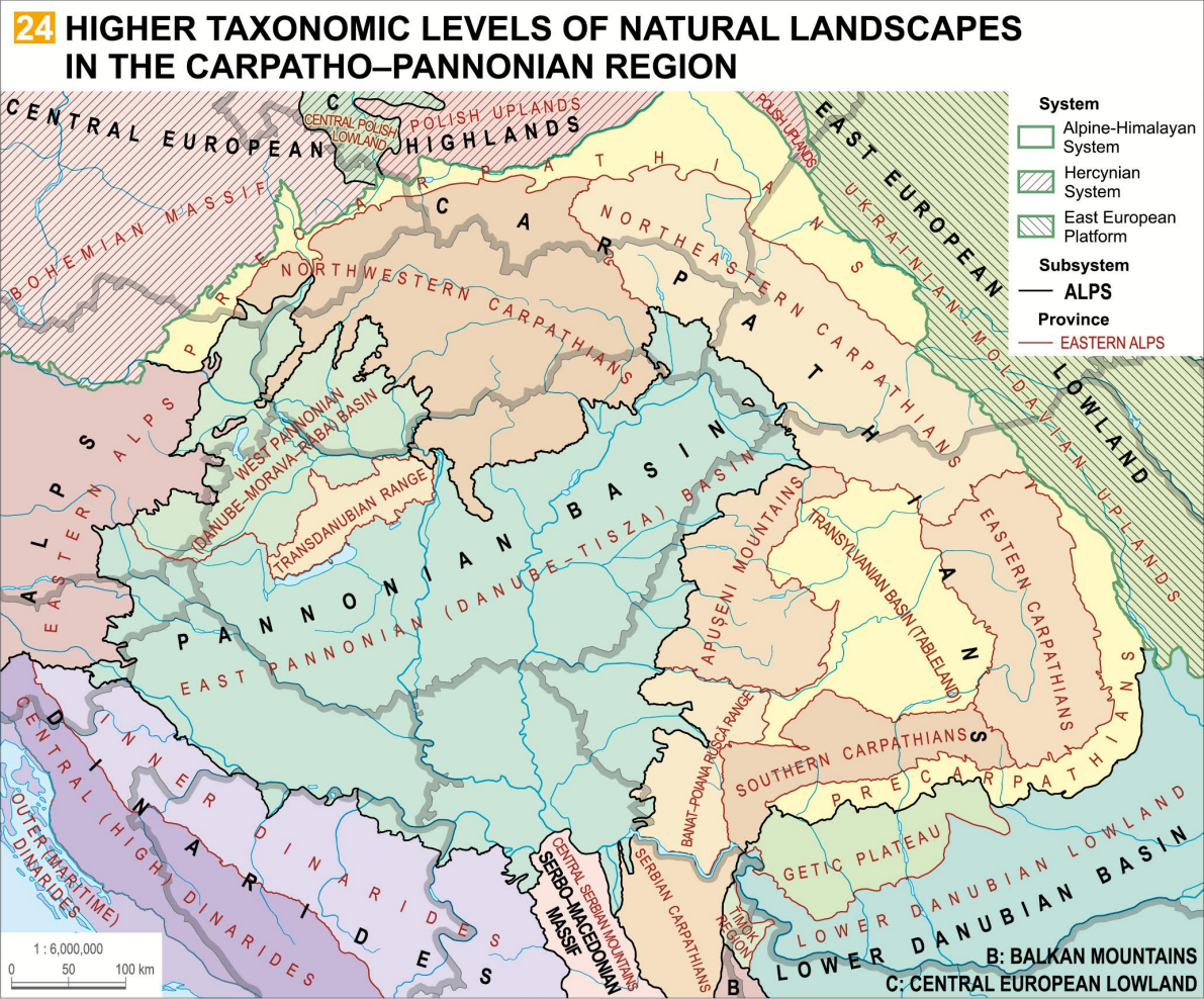
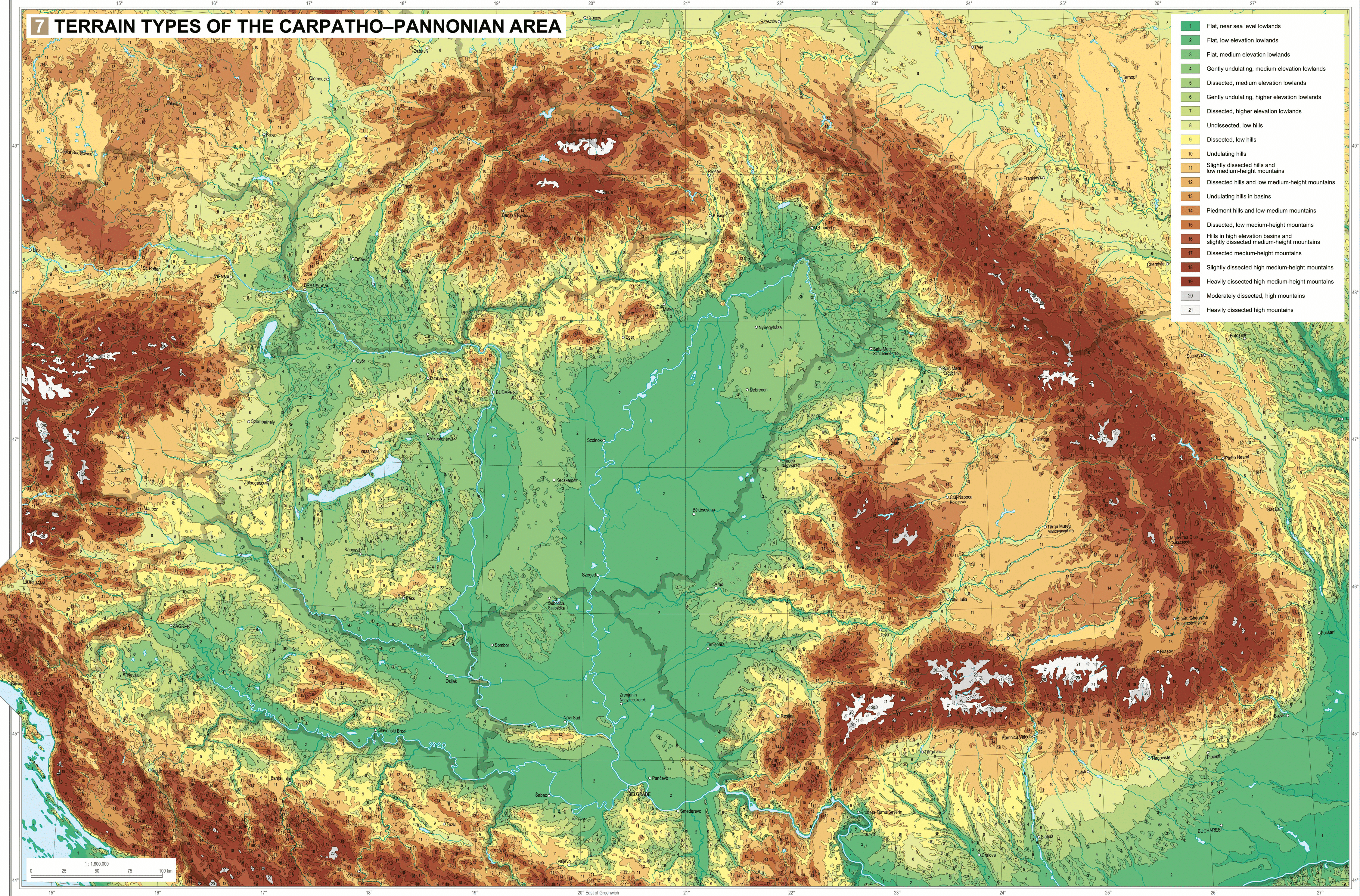
Transdanubia does not constitute a single consistent geographic area. There are mountains in the middle, plains in the East and Northwest, while the South and Southwest are marked by hills.

Transdanubia is an anachronistic division because it was first introduced in the ~18th century. I mean, it's right in the name: "Trans"danubia means "the land across the Danube". It's a naming convention that only makes sense if the capital is on the other side of the river, which was the case with Pozsony(Preßburg), not so much with Buda.

Geographically, the minting chambers and dioceses make more sense while they are also more fitting for most of the game's timespan (especially the first half).
 
  • 1Like
  • 1
Reactions:
Transdanubia does not constitute a single consistent geographic area. There are mountains in the middle, plains in the East and Northwest, while the South and Southwest are marked by hills.
I disagree, while it is not a single  geological feature, it is a real  geographical area with clearly definable borders that also serve as natural barriers from virtually every direction.

Transdanubia is an anachronistic division because it was first introduced in the ~18th century. I mean, it's right in the name: "Trans"danubia means "the land across the Danube". It's a naming convention that only makes sense if the capital is on the other side of the river, which was the case with Pozsony(Preßburg), not so much with Buda.
With all due respect, I cannot find any evidence for the claim that the term Dunántúl/Transdanubia didn't exist before the 18th century or that it was invented along with the military district in the 18th century that bore its name. In fact, I would argue that the district was probably named in turn after the already existing terminology.
For the claim that it was named that from Pozsony's POV - do you have any sources? I always thought (assumed?) that the "origo" was the center of the country between the Danube and the Tisza, hence why the terminology of Dunántúl, Tiszántúl and Duna-Tisza köze exist.

Geographically, the minting chambers and dioceses make more sense while they are also more fitting for most of the game's timespan (especially the first half).
Either way, I think minting chambers and dioceses, neither of which really follow any major landforms and have semi-arbitrary and border gorey shapes and spread, and are also smaller than the intended area sizes, would be a big mistake
 
  • 1Like
  • 1
Reactions:
With all due respect, I cannot find any evidence for the claim that the term Dunántúl/Transdanubia didn't exist before the 18th century or that it was invented along with the military district in the 18th century that bore its name. In fact, I would argue that the district was probably named in turn after the already existing terminology.
For the claim that it was named that from Pozsony's POV - do you have any sources? I always thought (assumed?) that the "origo" was the center of the country between the Danube and the Tisza, hence why the terminology of Dunántúl, Tiszántúl and Duna-Tisza köze exist.


Either way, I think minting chambers and dioceses, neither of which really follow any major landforms and have semi-arbitrary and border gorey shapes and spread, and are also smaller than the intended area sizes, would be a big mistake
I admit that the diocese or minting chamber borders do require some cleanup and merging to fit the purposes of PC's areas, but they are at least historically fitting for the start date.

Even if Transdanubia is chosen to be an area, it still shouldn't be called such. I remember reading somewhere that by the end of 15th century "Transdanubia" was used to describe Hungary East of the Danube, so today's "Danube-Tisza Interfluve". "Pannonia" could be a workable alternative but that would also need to include Slavonia to be accurate. A division to "Pannonia Hungarica" and "Pannonia Savia" could solve that issue in turn though.
 
  • 2
Reactions:
This looks informative but I’m not sure how to read it, is there a legend?
Those 'molehill'-like structures with the dots are the mining towns (they're also named). It's more or less a map which indicates which mines were productional at that time (around 1726). It's not the one thing I was leaning on when making the suggestion; I double-checked all town-names/mines, etc. And tried to look for other data, too. For example, I'm still looking for more information on iron (EDIT: Found out what I needed, edited the other post slightly). The map coincidentally shows 2 important mines in Wallachia, as well, which I'll talk about when I finish that post (which is fortunately slightly less work).

Here's the work-in-progress map I used for references, so it has some of the mines typed on it (not all of them were allocated correctly by me):
Transylvania mines map.jpg


The mine on the eastern edge is a bit of a mystery to me, still. Found no mention of it yet, but seeing how it's located between Brasov (Cronstad) and Sighisoara (Schesburg) doesn't make much of a difference. Those locations got a fitting tradegood, already. I also found out that the symbols mean which mineral was mined there (the plus is for copper, the circle with the horizontal stripe is for salt, the circle with the dot for gold and the upwards arrow for iron).

@mathuser Regarding Dukagjini: glad that you took a look, too. I think there's reason enough to rename/relocate the location, as the places you mentioned aren't villages/towns/castles, either. And the village of Dukagjin itself seems to be (very) unnoteworthy, with no castle or anything like it nearby. Not even on the maps of Medieval Serbia, Albania, etc. Unless the devs know something we don't (not an expert on Albania myself).
 
Last edited:
  • 1Love
Reactions:
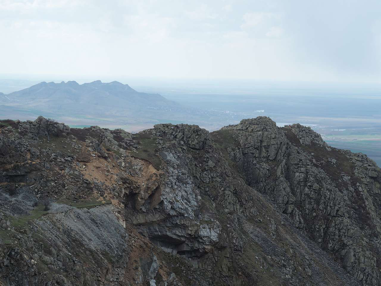
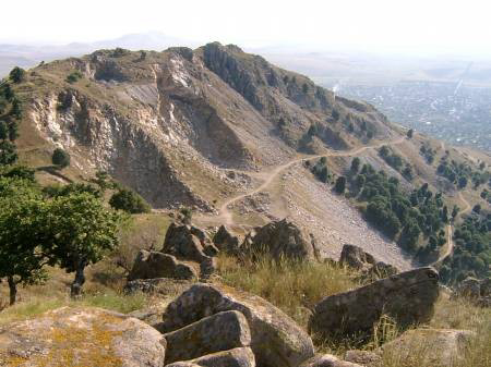
Ok, so it has been quite some time since this was posted and I wrote a reply about a possible "Măcin" location, covering western Tulcea and northern Hârșova in eastern Romania. I would like to continue on this topic here in a new post since we learned new information in the Scandinavia tinto maps that ANYTHING under 500 meters is automatically flatlands. I suggested that the Măcin mountains, the highest peak being at 467, should be enough of a landmark to justify splitting the ginormous Tulcea location in two. Under the previously cited rule of thumb, they are flatlands, wich is hilarious if you have ever been there in person like me. It is a fact that the region is extremely flat around the mountains not far from the see and is prone to inundations since it is surrounded by rivers. But the terrain is just so flat around the mountains that even if they are "just" 500 meters high, the contrast with the surrounding landscape make them functionally mountains in all aspects wich cannot be represented by numbers alone, showing how raw numbers and rules like "<500 = flat" do not represent reality well. They should at the very least be hills since their effect on human activity in the region is no different than that of smaller peaks in the Carpathians.

Here is a link to the wiki page for the Măcin mountains. I also strongly suggest searching for more images on google.

And here you have some pictures. You can easily see the contrast between the mountains/hills and the surrounding landscape.
1721555892702.png

1721555946985.png
 
  • 4Like
  • 2
Reactions:
This is the follow-up post on both Wallachia and Moldavia after the earlier suggestion on Transylvania (mainly regarding mineral-based tradegoods). It will also mention some miscellaneous stuff.


List of changes I'd make to Wallachia:
- Severin: Livestock -> Copper
- Calafat: Copper -> Wine/Livestock
- Ploesti: Wheat -> Salt
- Targu Bengai: Stone -> Iron (if the mines are indeed within the location, otherwise its borders should have to be changed somewhat)
- Rename Sacuieni to Bucov/Bucovu
- Possible but not recommended; Ramnicu Valcea: Livestock -> Salt (it's logical if only one Salt-tradegood is chosen for Wallachia. In that case, I'd go for Ploiesti)

List of changes I'd make to Moldavia:
- Targu Trotus: Stone -> Salt
- Merge of Tulnici and Focsani (with Focsani and the Clay-tradegood remaining, so, no more Salt-tradegood here)
- Targu Neamt: Iron -> Lumber/Stone
- Merge of Galati and Cudalbi (with Galati remaining)
- Maybe one/two less Wine-producing location in the eastern parts, and more Livestock instead. Maybe change one of the western locations to a Lumber-tradegood, too.
- Replacement of Cetatea Tetina (with either Kitsman or Onut)
- Renaming of Cahul to Scheia (its older name)


Sources and explanations on Wallachia:
- The map used for the post about Transylvania also depicts 2 important Wallachian mines: Baja di Rama (Baia de Arama) and Okna (Ocnele Mari). More on that later.
Wallachia - Medieval Minerals.PNG

- Wallachia's Wikipedia-article also mentions another important mine: Baia de Fier (iron). A note: Amber extraction in Buzau (in and around Colti) only skyrocketed in the 20th century, and for just around three decades. Medieval amber exploitation was too negligible to warrant a tradegood for it in this region.
- The paper called 'On the Medieval Urban Economy in Wallachia' (it's a free download/view if Googled) also mentions the following on Baia de Arama (copper) and salt-production, as well:
Baia de Arama.PNG

- The thing is, the one Copper-tradegood Wallachia currently has, has been assigned to the Calafat location. I did some research on the area, but I can't find copper-mines or deposits or anything of note around there that would warrant such a tradegood for this location. Baia de Arama, an actual copper mine, seems to be located within the Severin-location (this should always be checked, of course). So, the Copper-tradegood should be moved there.
- Calafat would do fine with just Livestock (always a safe bet for Wallachia), or maybe Wine (grapes are grown there). Wallachia produced quite a lot of wine, and it currently has no Wine-producing locations at all.
- There's the following (bit goofy-looking) infograph on Wallachian salt-trade:
Wallachia Salt - Infograph.PNG

It still encapsulates Wallachia's salt-production quite well. It depicts the sites of Salina Ocnele Mari near Ramnicu Valcea, and the likes of Telega and Slanic near Ploiesti.
- Ramnicu Valcea is quite a big location, and includes far more than just one salt-deposit (again; Livestock is very important for Wallachia). Wallachia would probably be fine with 'just' one Salt-producing location, so I'd opt for the Ploiesti-location, as it has multiple mining sites within its borders.
- Targu Bengai (nowadays knowns as Targu Carbunesti) seems to hold the earlier mentioned Baia de Fier iron-mine. The exact location should be checked, though. But Iron would be nice to have, instead of Stone.
- On another note: I think it has been mentioned by someone else, too, but Sacuieni is the name for the administrative region. Its regional capital was Bucov/Bucovu, which is a village nowadays, but was actually a town back in the 14th century. I think it should be renamed as such (it's also depicted on the salt-trade infograph).


Sources and explanations on Moldavia:
- Let's start with salt. The Moldavians acquired salt through two methods: evaporation of salt water and the mining of rock salt. The Ismail-location seems good enough for the current Salt-tradegood it has, as water evaporation indeed happened in its vicinity. Even though this method was in use in more places across the Danube delta and Bessarabia, pastoralism (because of the steppes) was more important/iconic for this region.
- This citation from the publication 'Salt Roads in Moldavia by the 18th Century' also supports this:
Salt Roads in Moldavia - Second citation.PNG

- Now on towards the rock salt deposits of Moldavia: there were actually quite a few, but with some caveats which I'll elaborate upon a bit later in this post. This citation from the same source mentions the following:
Salt Roads in Moldavia - Citation.PNG

- So, it's quite clear that the Targu Trotus location (which also encompasses the town of Targu Ocna) should produce Salt instead of Stone.
- Now regarding other mines/deposits; As the source says (and other articles, as well), too much supply was prevented by the authorities. So, it took a while before other such production-sites sprung up. Villagers needed (and still need) local supply for themselves and/or their animals, but large-scale exploitation isn't mentioned in other locations for much of the game's timeframe (the Salina Cacica mine near Suceava comes to mind, for example).
- So, even though Tulnici does indeed have rock salt deposits in its vicinity, which are used locally, it just doesn't warrant the Salt-tradegood. A New Technique for Salt Block Preparation (an article which also mentions the area) says the following about local use (nowadays and in antiquity), for example:
Salt 3.PNG

- And here's a bit where a comparison is made between this (old) method of salt exploitation and extensive mining in Transylvania:
Salt 4.PNG

- So, all of this makes the village too insignificant to be on the map, I'd suggest merging it with Focsani, which keeps the name and its tradegood (Clay).
- Now onwards to the Iron-tradegood: 2 iron-producing locations is a bit too much for Moldavia. Iron was mostly exploited on a local level, and not of a very high quality (lots of sulphur contamination). It also took until Austrian times before most of these sites were exploited on a larger scale.
- The area around Jakobeny/Iakobeni seems to be the most noteworthy one of these sites, with other mining towns like Stulpikany and Frassin within its vicinity. All of them located within the game's Campulung Moldovenesc location, it seems (I think?). So, that one Iron-tradegood stays as is. For those interested: there is some interesting history about this region on the site of The American Bucovina Society, talking about the settling of Zipser-Germans in the area and all that: https://bukovinasociety.org/bsa-files_history/bsa-file_history_the-austrian-period-e/
- Why Targu Neamt has the Iron-tradegood is more of a mystery to me, and quite redundant. The old capital of Baia might have had some iron deposits nearby, but I'm not sure if it's even located within Targu Neamt. I'd suggest changing the tradegood to Stone or Lumber (Moldavia could use both).
Moldova (1483).png

- Cudalbi didn't exist yet, and is insignificant, too. I'd suggest merging it with Galati (others have mentioned this, as well).
- Moldavia currently has 5 Wine-producing locations. I think that's a little excessive. More Livestock or maybe even Wool could never hurt in some of these areas (because of pastoralism and fields/steppes).
- The replacement of Cetatea Tetina has also been mentioned earlier in this thread (it's basically a part of the town of Cernauti), with Kitsman being the best contender (in my opinion). Though Onut is also possible.
- All of this would maybe create a better balance between east and west Moldavia in terms of location-sizes and -density.
 
Last edited:
  • 4
  • 3Like
Reactions:
Tried to reply but something bugged out so I'm replying again.

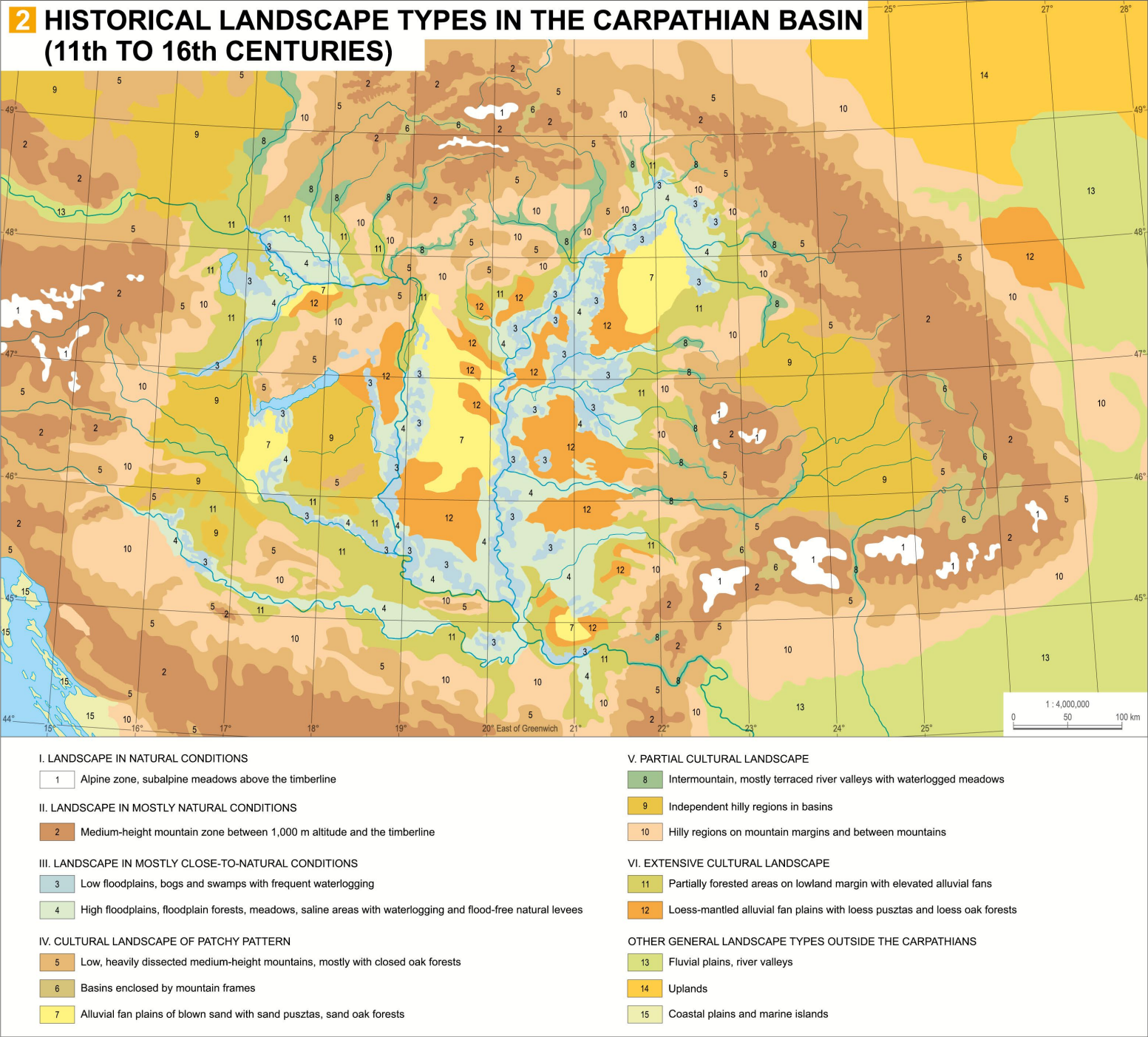
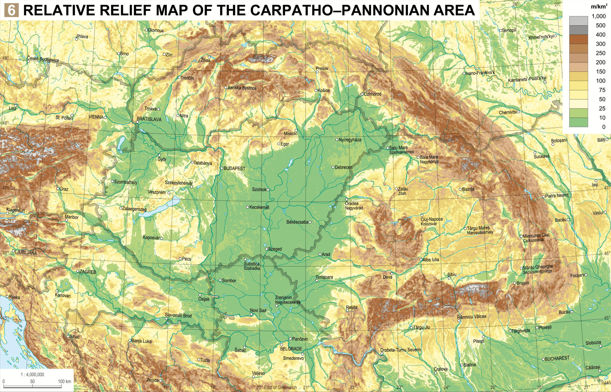
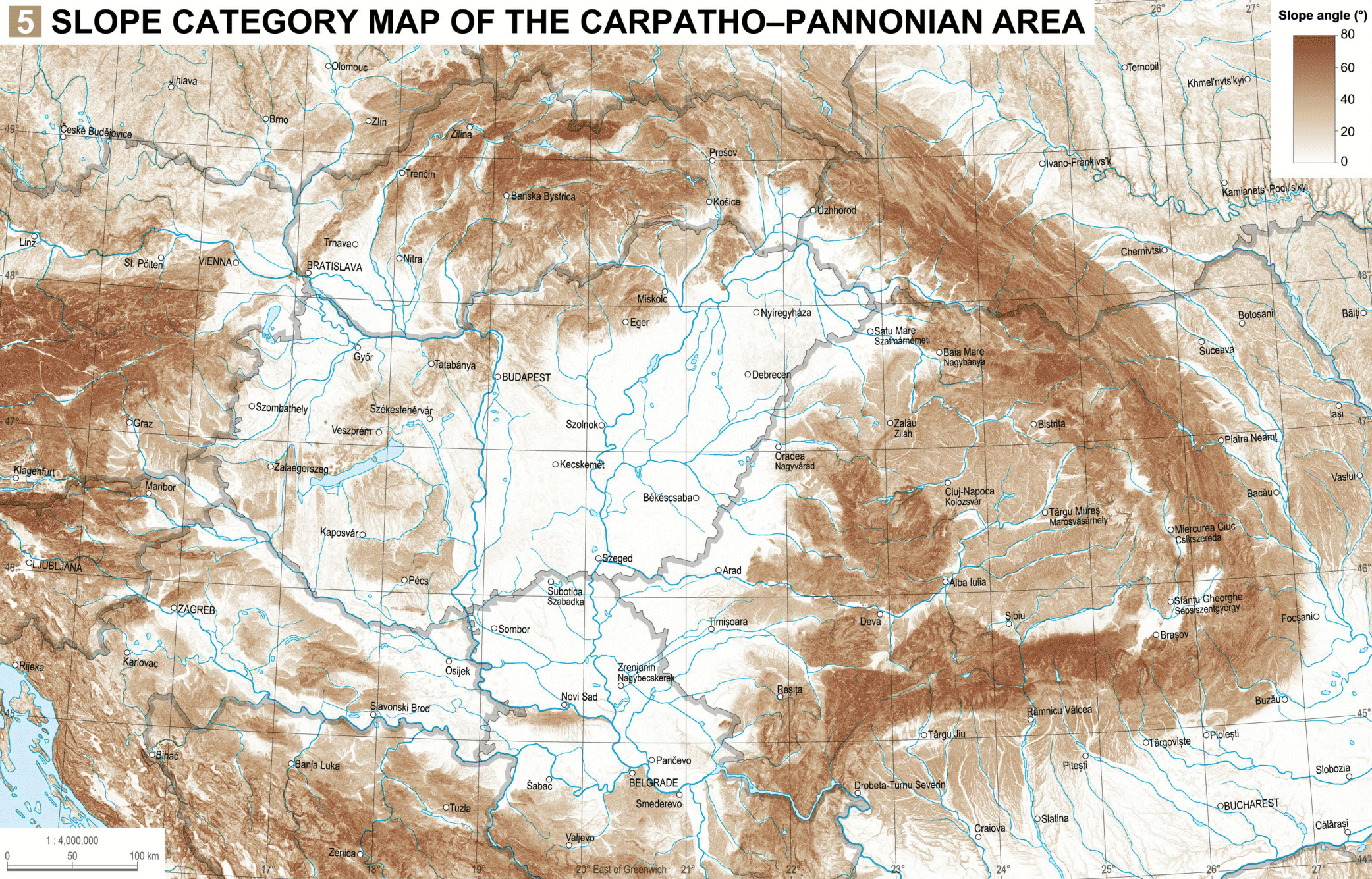
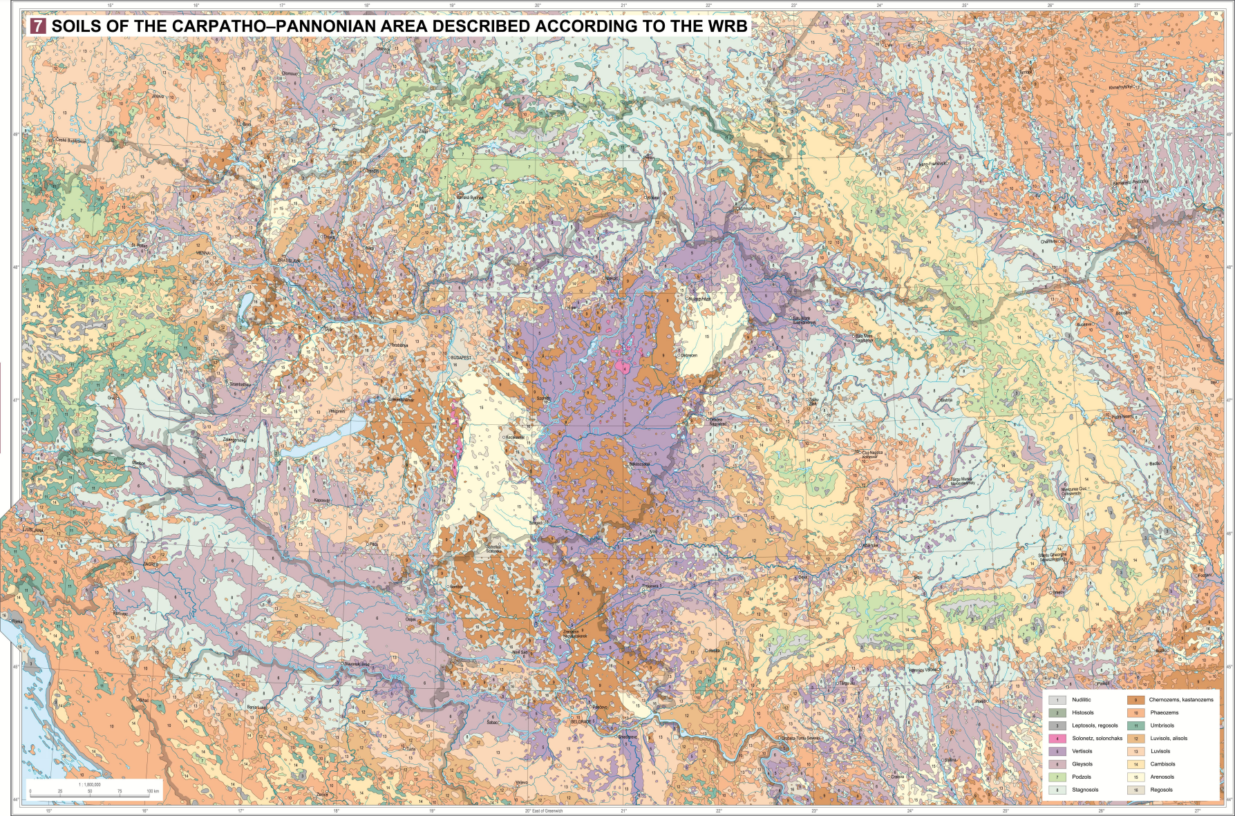
So, does the atlas perhaps have land use & vegetation cover maps from the game's timeframe? Spread of forestation, farmlands etc.
Not really. The closest thing to that is the first map in my previous post.
There are chapters that deal with waters, soils, and vegetation, but there no such convenient maps that could be 1:1 utilised.
Perhaps the soils map is the next most useful thing in there concerning the topic:
Soils of the Carpathian Basin described according to the WRB.png
 
  • 1
  • 1Like
Reactions:
I'm quite late to this one but some feedback.

Dalmatia is quite unhistorical in its borders, it seems a lot "thicker" than it should be.
The island of Pag should definitely be in Dalmatia, I would also consider adding Kotor to it as well.

I also hope you take the time to really flesh this region out, especially when it comes to dynamic culture names. I posted a list of them a while back that may be useful:
 
  • 2Like
Reactions:
Sátoraljaújhely replaced with Tokaj (and given Wine goods) or Sárospatak, and potentially made either into hills or plains
Alternatively, Satoraljaulhely could be split in two, the eastern half given to the already-existing Zemplen (marsh elevation, Hungarian with a tiny bit of Slovak), and the western half could become Tokaj (hill elevation, wine goods, Hungarian). It would ruin national borders but keeping those was a low priority anyway.
 
  • 1Like
  • 1
Reactions:
So @Pavía, I do not know if you are still reading this chat after so many comments, but I have decided to make a detailed province, location and area proposal for the Kingdom of Hungary, using some resources posted, because the more proposals, the better. For this, I have used multiple of the resources and maps shared in this thread, specifically the terrain maps shared by @Fehervari, this proposal by @SulphurAeron , and @purplephoton's own version of this task.

I also used these source maps for locations:
Hungary under the reign of Matthias I
Tabula Hungariae, map from 1528. It is hard to read due to the weird orientation and old spelling, but it was helpful nevertheless
Markets and fairs in medieval Hungary, which was useful in many cases in determining which settlement was more important and populous in a location
Castles in the 15. century, based on Engel Pál's works

My key guidelines:
  • follow historical county borders whenever possible without bordergore
  • I wrote every province and location name in Hungarian for simplicity (and because this was easier for me given that my Hungarian desktop keyboard doesn't have the special letters needed for Slovak, Romanian, or Saxon names); obviously they will all need dynamic localisation
  • dotted lines in each case mean that a division there would be ideal, but not necessary if not possible. I will try to give a quick reasoning in any of the special cases
  • locations are always named after a settlement in the region that existed in 1337. I used the form of every name that was used around the beginning of the timeframe, except if for some reason that wouldn't be ideal in my opinion
  • I kept the current locations and their borders if there was no problem with them
  • the goal density was the one seen in Serbia, Transylvania and Moravia
  • I did not care about modern borders

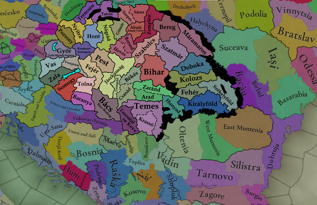
1. Provinces and Areas

Provinces were pretty straightforward in most places: I used the historic (14th-15th century) county borders when possible, and merged some smaller ones into larger ones if they would've been too small otherwise.
Examples of merged counties include:
  • Győr or Győr-Moson-Sopron, from Győr, Moson and Sopron
  • Komárom-Esztergom from these two
  • Bács or Bács-Bodrog from the two
  • Hont from Bars and Hont
  • Nógrád was given Zólyom (Zvolen)
  • the "Tatras" includes the three small counties in the Tatras; it has a dotted line with Trencín, indicating that ideally the two should be different, but honestly I'd be fine with them together
  • Gömör has Kishont, Abaúj has Torna (as it historically did after a while), Bereg has Ung (but I probably should have dotted lined this too)
  • Szatmár and Doboka have annexed several smaller ones (Kraszna, Ugocsa, Central and Inner-Szolnok, Beszterce)
  • Torontál/Keve have been merged, as they would be historically later on
  • the Jász and Kun seats have been merged with Outer-Szolnok to create the Jászkunság
  • kept the current provinces of Királyföld, Székelyföld, Fehér and Kolozs, but moved Reghin (Régen, Szászrégen) to Kolozs as it should be and split Hunyad from Fehér
On dotted lined ones:
  • Heves and Borsod: I really don't want to merge them, but will probably have to because they are not very big
  • Arad and Zaránd: I would be fine with big Arad, as they were merged later on in history, but I also wish it was possible to make the Banat have more or less accurate borders in the "small areas" section I will show later on
  • Csongrád-Csanád-Békés: on the smaller side and not easy to find resources for to make more locations, I would be fine with them as one. For the same reason as Arad, I'd also love if Csanád could be part of the Banat, and Békés and Csongrád could be merged, or split and merged into Bihar and Bács respectively, but I don't think that's ideal
  • Temes: Temes could annex Krassó, as the latter is quite small, but ideally should be separate
  • Szepes and Sáros: ideally separate, but can be merged if it is impossible
Győr-Moson-Sopron, Komárom-Esztergom, Abaúj-Torna and Bács-Bodrog are conjoined names that have existed or exist today, so I'd be okay with using them; other historically used conjoined names include "Gömör and Kishont" and Szolnok-Doboka, but I don't like those lol (but they do arguably make sense). Keep in mind that these hypehened names are all outside the timeframe of the game.

hungary_proposal_provinces.png


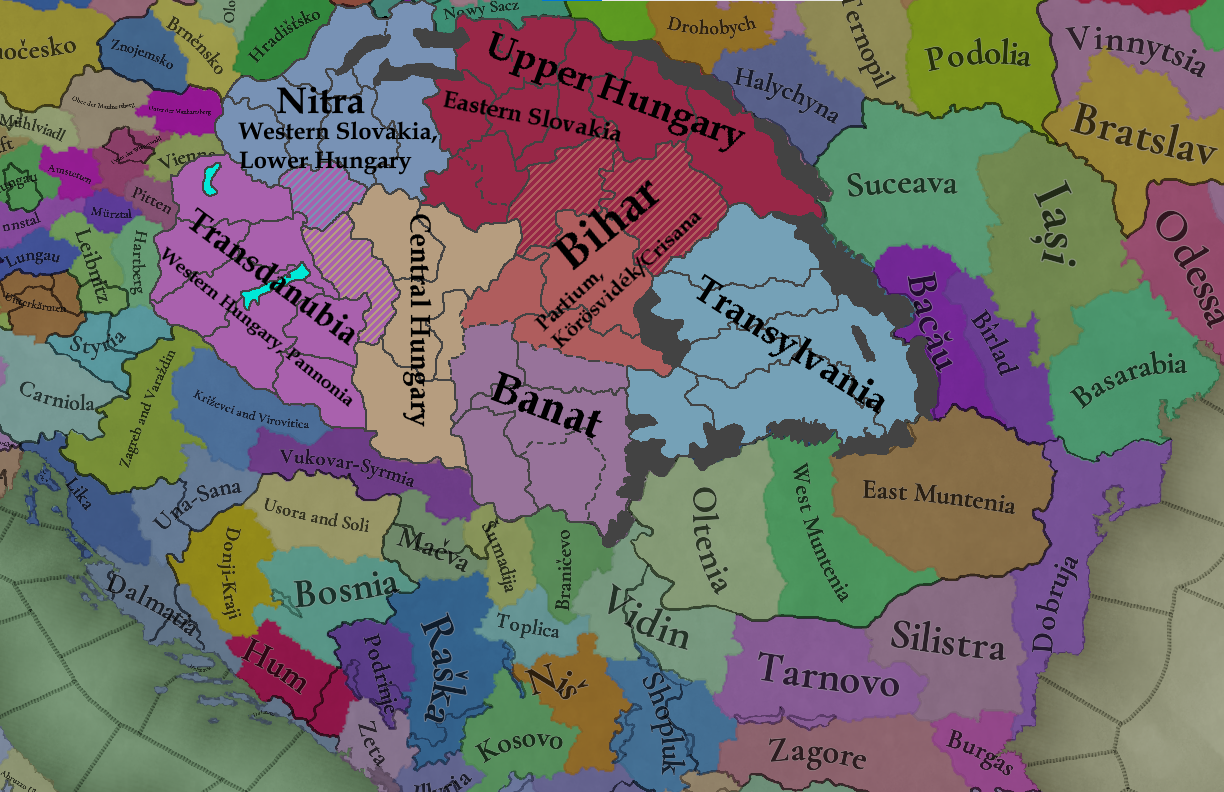
For Areas, I have two versions, a "Small" and a "Big" version, depending on what would be the ideal size according to the design principles of the game.
Small Areas:
The goal size of these areas is between c. 20-50 thousand km2.
  • Nitra: named after the medieval duchy with the approximate area. Alternative names include Western Slovakia, and Lower Hungary
  • Upper Hungary, after the principality and captaincy with the same name, or Eastern Slovakia
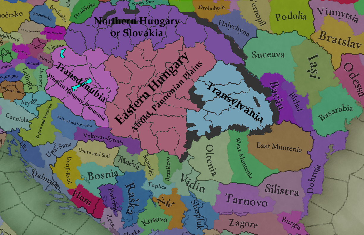
  • Transdanubia, which according to @Fehervari's research might be a bit anachronistic, so could also be called Western Hungary
  • Central Hungary, in the Danube-Tisza interfluve
  • Banat, including the counties that would traditionally be considered part of the Banat (so lands south of the Mures)
  • Bihar, alternatively named Partium or Körösvidék/Crișana
  • and Transylvania
As the counties that cross the Danube might be problematic for Transdanubia, Komárom-Esztergom could also be part of Nitra/Lower Hungary (given that Komárom was indeed part of Lower Hungary during the time when the said captaincy existed), and Fejér could maybe be Central Hungary.
Szabolcs and Szatmár were considered part of the Captaincy of Upper Hungary, but I think they would be better off in Bihar.

This setup would however require the alternative "split" version of Arad/Zaránd and Csongrád/Csanád/Békés

hungary_proposal_areas_small.png


Big Areas:
Alternatively, a setup with larger areas. I used to prefer the "small" version, but now I'm starting to be increasingly leaning towards this one.
  • Northern Hungary or Slovakia in the North
  • Transdanubia or Western Hungary in the west
  • Eastern Hungary, Alföld, Great Plains, Pannonian Plains etc. east of the Danube (any name works)
  • and again, Transylvania

hungary_proposal_areas_big.png

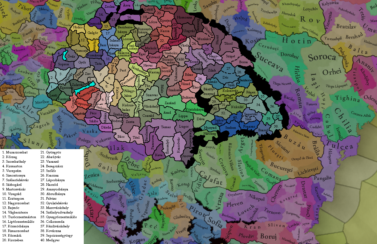
2. Locations

I mostly based these on the settlements found on the maps I have linked as sources. The "algorithm" for choosing which towns to represent in a location:
  1. always preferred to use county capitals when I could (if I could determine what was the county capital in 1337)
  2. on this map, I preferred the settlements more high-ranking in the "hierarchy" (free royal cities with castles or walls > free royal cities > field towns with castles or walls > castles > field towns > villages)
  3. if similar sized and have the same "tier", I read into their history to see if they had any more privileges than the other one
  4. if I still can't decide, I will choose the historically more notable one (eg. seat of a famous noble dynasty, site of a battle, site of a historical National Assembly eg. Szécsény, or a settlement that would later gain any other form of iportance)
When naming locations, I preferred to choose forms of the names that were attested around 1337. However, I did make some anachronistic exceptions in Székely seats and the Tatras. My reasoning was that naming the locations in these cases after settlements would completely remove every reference to the historical counties and sedes they represent; thus I used:
- Turócszentmárton, to have Turóc (Turiec) represented
- Liptószentmiklós, to have Liptó (Liptov)
- Marosvásárhely, instead of Székelyvásárhely or Vásárhely, to hame a reference to Marosszék
etc.

This is probably controversial, but can be changed. I also opted for Vágbeszterce in order not to have two locations named Beszterce.
Other notes:
  • I opted for Vásárhely instead of Hódvásárhely and Almás instead of Hídalmás. Even though both Hódvásárhely and Hídalmás appear shortly before or after 1337, I chose these versions because they are the ones present on Tabula Hungariae in 1528, so they probably were the more relevant naming convention if they were still preferred in the 1500s
  • Érsomlyó is known as Vrsac (Versec) today
  • there are also some dotted lined subdivisions here:
    • I really do hope Visegrád and Buda could be separate locations, given that both are extremely important
    • similar for Szeged and Csongrád
    • Borsa, could also be named Cuhea (Hung: Konyha); the first voivode of the short-lived Voivodeship of Maramureș and later of Moldavia, Bogdan, was from Cuhea. Both Borsa and Cuhea were seats of keneziates
    • I do not have strong opinions on the rest, but I would prefer them as separate locations
  • although I did not plan on modifying impassables, I think it would be nice if we could have:
    • the Verecke Pass
    • lake Fertő
    • historically more accurate Balaton maybe
    • impassable Hargita between Udvarhelyszék and Csíkszék
    • reorganized passes around the Tatras and the Fatras
I didn't count how many locations this is overall, but it's a lot!
In some areas, it turned out more or less the same as @purplephoton's version. This is either because we used the same source(s), or because this is literally the best way to do it lol.

hungary_proposal_locations.png


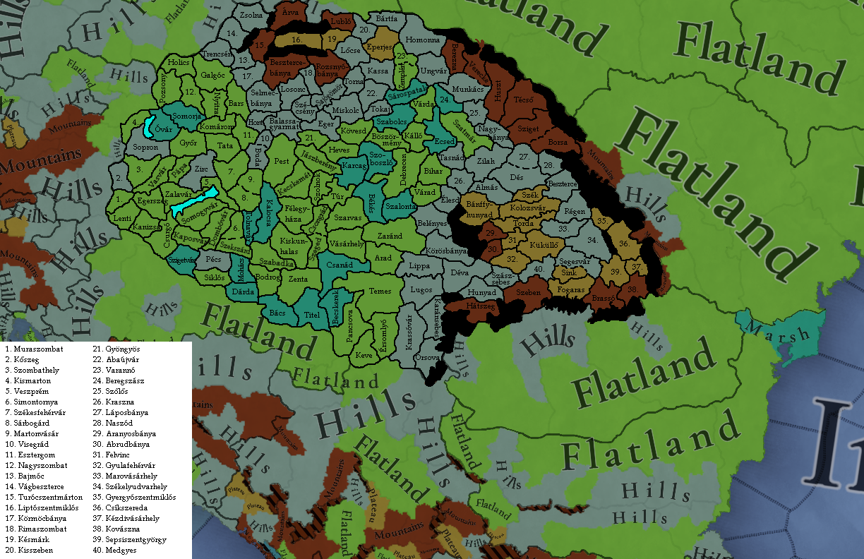
3. Topology

I used the topology maps posted by @Fehervari earlier, and @SulphurAeron's proposal for the hills, plateaus and mountains, and the wetland areas. Notes:
    • Buda and Visegrád should be hills, with Buda having farmlands vegetation and producing wine (important wine region), and Visegrád being forested and producing wild game (royal hunting grounds in the Pilis)
    • Zirc is hills because of the Bakony, but it could also arguably be plateau as well
    • Pécs is hills because of the Mecsek
    • some notable wetlands:
    [*]
hungary_proposal_topology.png


I did not make a vegetation map, as I will need more resources for that. Let me know what you think!
 
Last edited:
  • 16Like
  • 7Love
  • 1
  • 1
Reactions:
@ArVass I'd understand if the devs might go for slightly less granularity, and/or have their own vision on certain regions, but I absolutely love your work man. I see lots and lots of places I'd like to see on the map, and your research/list of explanations is also well done.

When the new version comes out, I'll take another look at some of the tradegoods in the region - especially Slovakia, which I didn't touch in my earlier suggestion - I hope you may be able to help me out, when the time comes. As it's quite puzzling to me here and there ;)
 
  • 2Like
  • 1Love
Reactions:
@ArVass I'd understand if the devs might go for slightly less granularity, and/or have their own vision on certain regions, but I absolutely love your work man. I see lots and lots of places I'd like to see on the map, and your research/list of explanations is also well done.
They did say they want more granularity, and since surrounding areas (Transylvania, Serbia, Central Moldavia, and Moravia) have a similarly high level of granularity, I'm confident the Devs want to fill the connecting middle region (so Hungary and Slovakia) with an equally high granularity too.

Otherwise, I'm going to have to eat Johan alive.

When the new version comes out, I'll take another look at some of the tradegoods in the region - especially Slovakia, which I didn't touch in my earlier suggestion - I hope you may be able to help me out, when the time comes. As it's quite puzzling to me here and there ;)
That would be amazing! I'm help when I can. In the mean time, I'm looking for vegetation resources... I'm sure most of it is grasslands and farmlands but there still must be a lot of woods and forests, and I also know that as the climate changed around vegetation changed dramatically as well; I'll update when I know something
 
  • 2Like
  • 1
Reactions:
So @Pavía, I do not know if you are still reading this chat after so many comments, but I have decided to make a detailed province, location and area proposal for the Kingdom of Hungary, using some resources posted, because the more proposals, the better. For this, I have used multiple of the resources and maps shared in this thread, specifically the terrain maps shared by @Fehervari, this proposal by @SulphurAeron , and @purplephoton's own version of this task.
Funnily enough, I was just looking at ways to improve my proposal, when this beauty came out.
 
  • 3Like
  • 1Love
Reactions: