• We have updated our Community Code of Conduct. Please read through the new rules for the forum that are an integral part of Paradox Interactive’s User Agreement.

Tinto Maps #9 - 5th of July 2024 - Carpathia and the Balkans

Greetings, and welcome to another Tinto Maps! This week we will be taking a look at Carpathia and the Balkans! It will most likely be an interesting region to take a look at, with a lot of passion involved… So I’ll just make an initial friendly reminder to keep a civil discussion, as in the latest Tinto Maps, as that’s the easiest way for us to read and gather your feedback, and improve the region in a future iteration. And now, let’s start with the maps!

Countries:
Countries.png

Carpathia and the Balkans start in a very interesting situation. The Kingdom of Hungary probably stands as the most powerful country in 1337, but that only happened after the recovery of the royal power enforced by Charles I Robert of the House of Anjou, who reined in the powerful Hungarian nobility. To the south, the power that is on the rise is the Kingdom of Serbia, ruled by Stefan Uroš IV Dušan, who has set his eyes on his neighbors to expand his power. The Byzantine Empire, meanwhile, is in a difficult position, as internal struggles ended in Andronikos III being crowned sole emperor, at the cost of dividing the realm; both Serbia and Bulgaria have in the past pressed over the bordering lands, while the Ottomans have very recently conquered Nicomedia. The control over the Southern Balkans is also very fractioned, with a branch of the Anjou ruling over Albania, the Despotate of Epirus under the nominal rule of Byzantium as a vassal, Athens, Neopatria and Salona as vassals of the Aragonese Kings of Sicily, Anjou protectorates over Achaia and Naxos, and only nominal Byzantine control over Southern Morea. It’s also noticeable the presence of the Republics of Venice and Genoa, which control several outposts over the Adriatic and Aegean Seas. A final note: in previous maps, Moldavia was shown in the map, but we’ve removed it from it, and it will most likely spawn through a chain of events in the 1340s.

Dynasties:
Dynasties.png

The House of Anjou rules over Naples, Hungary, Albania, Achaia, and Cephalonia; they’re truly invested in their push for supremacy over the region. Apart from that, each country is ruled by different dynasties, except for Athens and Neopatria, ruled by the House of Aragón-Barcelona.

Locations:
Locations 1.png

Locations 2.png

Locations 3.png

Locations 4.png
This week we’re posting the general map of the region, along with some more detailed maps, that can be seen if you click on the spoiler button. A starting comment is that the location density of Hungary is noticeably not very high; the reason is that it was one of the first European maps that we made, and we based it upon the historical counties. Therefore, I’m already saying in advance that this will be an area that we want to give more density when we do the review of the region; any help regarding that is welcome. Apart from that, you may notice on the more detailed maps that Crete appears in one, while not being present in the previous one; because of the zooming, the island will appear next week along with Cyprus, but I wanted to make an early sneak peek of the locations, given that is possible with this closer zoom level. Apart from that, I’m also saying in advance that we will make an important review of the Aegean Islands, so do not take them as a reference for anything, please.

Provinces:
Provinces.png

Provinces! Nothing outstanding to be commented on here; as usual, we’re open to any feedback regarding them.

Terrain:
Climate.png

Topography.png

Vegetation.png

Terrain! The climate of the region is mostly divided between Continental and Mediterranean, with some warmer and some colder regions. Regarding the topography, the Carpathian mountains are famously important and strategic, while the Balkans are a quite hilly and mountainous region, which is also greatly covered by woods and forests.

Cultures:
Cultures.png

Here comes the fun part of the DD: The cultural division of the Balkans! A few comments:
  1. Hungary is full of different minorities. Transylvania, especially, is an interesting place: there we have a mix of ‘Hungarians’, ‘Transylvanians’ (which are the Romanian-speaking inhabitants of the region), ‘Transylvanian Germans’, and ‘Szekely’ people.
  2. We have divided the Southern Slavic-speaking region into their dialectal families of Slovene, Croatian, Bosnian, and Serbian.
  3. The Southern Balkans are mostly divided among Bulgarian, Albanian, and Greek cultures.
  4. We’re also portraying plenty of other cultures, such as Dalmatians, Aromanians, Sclavenes, Arvanites, Cumans, Jasz, or Ashkenazi and Romanyoti Jews.

Religions:
Religion.png

This one is also interesting. Apart from the divide between Western Catholicism and Eastern Orthodoxy, we have the Krstjani in Bosnia, Bogomils (the pink stripes both in Bosnia and Macedonia), and Paulicians in Thrace. The Jewish populations do not pass the threshold percentage to appear on the map, but there are plenty of communities across the region.

Raw Materials:
Raw Materials.png

The materials of the region. Something very noticeable is the richness of minerals, with plenty of Iron, Copper, Tin, Lead, Gold, and Silver. Specifically, Slovakia is very rich, and you definitely want more settlers to migrate to the region, and exploit its resources. The region is also very rich in agricultural resources, as you can see.

Markets:
Markets.png

The region is mostly divided among four markets: Venice, Pest, Ragusa and Constantinople.

Country and Location population:
Population 1.png

Population 2.png

Population 3.png

Population 4.png
Country and location population (which I’ve also sub-divided, and is under the Spoiler button).

And that’s all of today! I hope that you find the region interesting; we certainly think that it is. Next week we will go further south, and we will take a look at the Syrian Levant and Egypt. Cheers!
 
  • 193Like
  • 69Love
  • 7
  • 4
  • 3
  • 1Haha
Reactions:
Can some Bulgarian friend suggest a way to satisfactorily split Drastar up so that it won't look weird on the map if Wallachia gets control of it, like it did historically under Mircea?
Tara_Rumaneasca_map.png

Wouldn't Cozmeni (Ger: Kitzman) be a better location, then?
I did suggest Coțmani as one of the possible replacements, yes. It's not a bad choice.
 
  • 4Like
Reactions:
1720217676462.png

This map leaves alot to be desired, I disagree with Debar (should be named Dibra though cause dynamic names) and to a lesser extent Shkoder not having albanians as the majority. My biggest gripe is with Epirus mostly. The colours are TERRIBLE. I cannot even tell if something is Albanian or Aromanian. Aromanian and Albanian are a seperate thing so why do they have the exact same colour. I do not know why Serbia and Albania switched their EU4 colours around but it clearly was a bad decision. Only positive I can say is the devs succeeded in avoiding arguments about ethnicity by making it impossible to tell where Aromanians and Albanians are on the map. On another note in the 1340s and 1350s there was a migration of several albanian clans who some are known to be ancestors of the Arvanites into Epirus. I know the game starts in 1337 but I doubt there will be a event to simulate this so I would suggest simply bumping up the population numbers by a bit so we can reflect that even if its 4 years too early.
 
  • 4Like
  • 1
Reactions:
I'm sorry if there are some repetitions, I haven't read all comments. There have benne some talks about the cities in Hungary so I opend up my old history books and by 1342 (death of Charles I) these were the settlements with official city satuts: Buda, Pozsony (Bratislava), Sopron, Nagyszombat (Trnava), Kassa (Kosice), Bartfa (Bardejov), Eperjes (Prešov ) in the North. Zabreb in Croatia, Nagyszeben (Sibiu) and Brasso (Brasov) in Transylvania. These were the classical cities, surrounded by walls. They were free the elect their "majors' and judges, and payed taxes only to the king. Fun fact: Pest only recives the city status (from king Matthias) about 130 years after Europa Univ... Project Ceasar starts.
There were at least three "minecities": Kormocbanya (Kremnica ), Selmesbamya (Banská Štiavnica) and Besztercebanya (Banská Bystrica). (I'm sure I've missed some but these were the largest.)
What made them cities, was the king, and the law stated, that from these cities the tax from trade went directly to the crown not the estates, therefore most of these are on the border of the kingdom.
However there were de facto cities, sattlements without the official royal decree, the largest were: Debrecen, Szeged, Pecs, and maybe Zala. However they did not have walls. They are what we call "fieldcities" or Oppidums.
It's also worth to mention that the first cities (settlements with walls) were formed after the Mongol invasion of 1242, this is why there is so few of them and there will be some more by the time of the next purge of Hungary after the fall of Belgrade and the Battle of Mohacs.
Most of the cities (excluding the Oppidums) were german, I've only found "data" from Buda where the majority was Saxon, while Hungarians and Jews made up the rest. Fun fact: "In 1251 a privilegium was granted by Béla to his Jewish subjects which was essentially the same as that granted by Duke Frederick II the Quarrelsome to the Austrian Jews in 1244, but which Béla modified to suit the conditions of Hungary. This privilegium remained in force down to the Battle of Mohács." Meanwhile the mining cities were almost entirly german which made them funny places during the reformation, since their population mostly and quickly converted.

Therefore I think the naming of the cities should be german just like in the case of Bratislava, which had a German majority even in the 19th century. Also german looks better on the map. It's Kolozsvár not Koloszvár, and instead of Csongrád please use Szeged.

And I realy realy would love not to have Budapest (this world was invented in 1873), but the far cooler (and actually used that time) Pest-Buda as the name of the region.
If you need Hungarian localization just ask for help and please don't use those wierd names like Zalău or Baia Mare and there are many, many more.

Sadly I can't give you a full list of minecities since, I haven't found any credible source that sais which were given the status by 1342 (and I'm to lazy to individualy google), however I'm more than happy to help with in any further questions. Thank you for reading and have a great day.
 
  • 1
Reactions:
There should be way more Catholics in Bosnia of Croatian/Bosnian culture, Kingdom of Croatia ruled most of that land during 925–1102 it would have left mark.


From looking at this map it would seem that there was more % of Catholics after the end of 5 century of Ottoman rule than in 1337, which makes no sense as Catholic Bosnians/Croats fled en masse to Dalmatian cities and islands during Ottoman invasion.
 
  • 3
  • 2
  • 1Like
  • 1
Reactions:
Of course it isn't.

They hate Denmark.
They are indifferent towards Romania.

I'm only half-joking.
Well, in this case, they have specifically asked for any and all feedback, including about Romania (as it is part of the region discussed) and its situation and setup. They have also already shown how much they are willing to change after being given feedback, from adding locations to changing topography, culture setup, nation setup, etc. Not to dismiss your feelings (I've come across a lot of issues in the setup of Croatia in previous games myself and in what they've showed here so far, as per my post), but at least this time they are willing to give you (and everyone else here) a hand. Keep in mind that they're not just trying to get accurate Romania, but as close to accurate the entire world (as is the aim for their games generally). It's hard not to make mistakes or overlook things. This time, though, since they are extending their hand, try to be hopeful and wait for when they release the revised version of the maps sometime in the future. If things look bad after all this feedback, then go flame em all you want as far as I'm concerned :D
 
  • 7Like
  • 1
Reactions:
As an addendum, given that Melnik was being negotiated as a part of the civil war as transferring between Byzantine ownership and going to Hrelja (who was planning to return to Serbia), it is safe to assume that Melnik belonging to the Byzantines in 1337 is correct.
 
  • 1
  • 1Like
Reactions:
Well, in this case, they have specifically asked for any and all feedback, including about Romania (as it is part of the region discussed) and its situation and setup. They have also already shown how much they are willing to change after being given feedback, from adding locations to changing topography, culture setup, nation setup, etc. Not to dismiss your feelings (I've come across a lot of issues in the setup of Croatia in previous games myself and in what they've showed here so far, as per my post), but at least this time they are willing to give you (and everyone else here) a hand. Keep in mind that they're not just trying to get accurate Romania, but as close to accurate the entire world (as is the aim for their games generally). It's hard not to make mistakes or overlook things. This time, though, since they are extending their hand, try to be hopeful and wait for when they release the revised version of the maps sometime in the future. If things look back after all this feedback, then go flame em all you want as far as I'm concerned :D
How could I believe such a thing when I made this topic 1 month ago:
There were a lot of in-depth thing there.

But not even the basic issues were changed (from what we could see from the corners of other maps back then), let alone the more advanced things?

I really wish to believe you. But how can I do so when for example, they knew that Wallachia/Transylvania made no sense, and they still made a Wallachia/Transylvania split for some reason. To name one of the most basic ones, not even going into the fine details mentioned in the topic.
 
  • 2Haha
  • 1
Reactions:
I definitely agree with proposals to make Mount Athos unique and a separate tag that is autonomous. I also came to the conclusion that you could add some Christian Pecheneg Turks in regions named after Pechenegs. I also will make a list of Turkish names of the places in Balkans if I can, so stay tuned.
Mount Athos being its own province and tag is sensible but it being outright independent (as in, shown on the map, I know they'd be a vassal) during the game's timeline doesn't sit right with me. I think it's best represented as a modifier or perhaps making use of the Control mechanic.
 
Last edited:
  • 6
Reactions:
Finally the Balkan maps, gonna use a chance to add some feedback from the Serbian side, although I'm generally very satisfied with the majority of things here, the research was very well done.

1. The inclusion of Bodrog as a location is great, and I think it deserves a dedicated event. In the late 16 century Bodrog was sunk due to the shift of Danube, it was completely abandoned and it would take around 300 years for it to be located.

2. Provinces - I'm not a hundred percent sure about some of the province names. Usora and Soli are just two smalled geographical regions lumped together, something more general like Posavina (land by the river Sava) would work better. Kind of a same problem for many of Croatian ones, Vukovar and Syrmia for example is a city and a region adjacent to it, if they have to be the same province I'd go with Slavonija. The one big issue I have is Illyria. I don't think that name was ever used to refer for that specific region, as much as I hate provinces having city names, Skadar/Shkoder is by far the most important settlement there and the entire area can really just be defined as Skadar and it's surroundings.

3. Locations - I'll go through this further but now I can see that there's been a typo with Peč instead of Peć, and I assume that the localization is not finished, since Sremska Mitrovica should be Szávaszentdemeter in Hungarian, Srijemska Mitrovica in Croatian, and Sirmium as a name of the famous Roman settlement can be used for Greek or Western states if preferred. Trgovište should absolutely be called Ras, that fortress was the capital before Dušan moved it. Priština also has a mark on s when spelled in Serbian, Albanians do it as Prishtina.

4. Culture - I find some of the ethnic borders of Serbian population a bit strange. Having that much population north of Sava and Danube doesn't make too much sense to me. Belgrade was hardly a Serbian city until a century after. I understand some minorities but several locations with a majority seems a bit too much. (EDIT: Found some sources mentioning Serbian population as far north as Csanad, I assume devs have a good source on this cultural border) On the other hand, the Western border is strange. Historically Serbian states included the regions closer to the Adriatic sea, it's fine to consider Bosnians a separate culture, but their extend south is way overstated. Travunia was not a part of Bosnia until the end of 14th century, and Hum spend a very considerable time ruled by the Serbian dynasties. I propose Serbian majority in Lesinje and Gacko, and Serbian minority in Mostar.

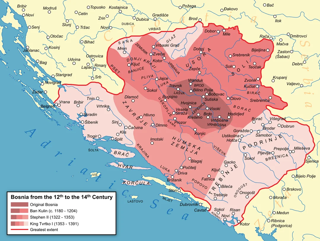
I think this map of Bosnia should help. As a ethnic-national identity I don't think Bosnian culture should extend farther south thatn the areas they controlled pre-Tvrtko.

1720221029496.png


Other borders seem mostly fine. I wouldn't be too generous with the Albanian population in present day Kosovo (eastern part was traditionally referred by that name), as many of those areas got populated heavier after Serbs started migrating north.

Edit 1: Increasing the Hungarian location density
 

Attachments

  • 1720313265908.png
    1720313265908.png
    284,2 KB · Views: 0
Last edited:
  • 7
  • 2Like
  • 1Love
Reactions:
How is Shkodër not albanian majority? The venetian and the papal documents show an absolute majority of albanians. Same thing about Debar (Skanderbeg's family comes from that area). No history book or even the most nationalistic maps show Debar as anything other than albanian. In northern epirus and western parts of modern day North Macedonia every noble family (Arianiti, Shpata, Muzaka, Zenevisi, Gropa) was of albanian origins and the majority of the population was albanian. If you do research about the fall of the Serbian Empire, the same families appear in these areas. For example: The Shpata house (Argyrokastra/Argyrokastro area) became vassals of the byzantines after the Serbian empire fell.
Suggested changes:
- Shkodër, Avlonas, Debar, Dakovica, Devoll, Prizren become albanian majority.
- Argyrokastro, Tetovo, Ohrid become albanian with greek and bulgarian minorities respectively.
- Albanian minorities get removed from Italy (they migrated after Skanderbeg's death).
- Make the Arvanitas minorities shown near Athens and in small parts of Morea.

Considering the fact that albanians are not mentioned at all in CK3 and in EU4 they are considered southern slavs really shows how little information you have about this area. I am ready to help with sources and translations if needed.
Yes to this. Espacially for Prizren the book "Kosovo: a Short history" provides great sources and perspective on the region and can be found on archive.org with a search function to find what specifically one is looking for.
 
  • 1Like
Reactions:
Can some Bulgarian friend suggest a way to satisfactorily split Drastar up so that it won't look weird on the map if Wallachia gets control of it, like it did historically under Mircea?

Only way I can think is to increase the size of Ovech and/or Karvuna. There have been posts by kagami1999 suggesting that there wasn't anything in between Drastar and way south near Ovech/Karvuna areas
 
  • 2Like
  • 1
Reactions:
How could I believe such a thing when I made this topic 1 month ago:
There were a lot of in-depth thing there.

But not even the basic issues were changed (from what we could see from the corners of other maps back then), let alone the more advanced things?

I really wish to believe you. But how can I do so when for example, they knew that Wallachia/Transylvania made no sense, and they still made a Wallachia/Transylvania split for some reason. To name one of the most basic ones, not even going into the fine details mentioned in the topic.
Well, they have stated before that they will specifically take feedback *in* these map threads I believe from the original map thread (or the second one). I get your point but I think they simply wanted an easier way of accessing all information about certain regions in one place rather than having to wade through suggestions threads in hopes of finding something. They've also stated this was one of the first regions they've created (and nothing about having revisited them - they did not revisit *Spain*, where Tinto is placed, until after the map post of Iberia, where you could see huge changes after the feedback thread) - perhaps they read your post, but had other priorities, and now that this has come on the table and they are specifically taking feedback for this, your post will be noted and acted upon. Again, I'm not saying it's certain, but my suggestion is to wait for the results of whenever they revise the region! :D
 
  • 3Like
  • 2
Reactions:
Well, they have stated before that they will specifically take feedback *in* these map threads I believe from the original map thread (or the second one). I get your point but I think they simply wanted an easier way of accessing all information about certain regions in one place rather than having to wade through suggestions threads in hopes of finding something. They've also stated this was one of the first regions they've created (and nothing about having revisited them - they did not revisit *Spain*, where Tinto is placed, until after the map post of Iberia, where you could see huge changes after the feedback thread) - perhaps they read your post, but had other priorities, and now that this has come on the table and they are specifically taking feedback for this, your post will be noted and acted upon. Again, I'm not saying it's certain, but my suggestion is to wait for the results of whenever they revise the region! :D
I really hope you are right, but just look at all the traction the topic got:

Thetopic.jpg

I mean, if they just "missed" this topic, what else can you say about other topics who do not have 41 positive reactions and 4 negative reactions?\

I really have a hard time to believe they didn't see this topic. There's a slim chance, but.... fat chance. (sometimes english language is a blessing, slim chance and fat chance mean the same thing)
 
  • 2Like
Reactions:
Thank you for yet another lovely map reveal and dev diary. The game is looking great and I am excited to play it and I'm excited for the development team and all those involved. That being said, here are a few suggestions for the map to help with accuracy:

They can all be found in the comment I wrote on Lord Lambert's Youtube video covering this tinto map:

Look for the user "@theopapoulis4239"

Thank you,
 
  • 1Like
Reactions:
I really hope you are right, but just look at all the traction the topic got:

View attachment 1159088
I mean, if they just "missed" this topic, what else can you say about other topics who do not have 41 positive reactions and 4 negative reactions?\

I really have a hard time to believe they didn't see this topic. There's a slim chance, but.... fat chance. (sometimes english language is a blessing, slim chance and fat chance mean the same thing)
Lmao fair on the last bit. But I've said maybe they saw, maybe they didn't. If you don't want to get your hopes up, that's fine too. In that case, I will hope for you that your wish of Romania's situation being fixed ends up true in your stead! :D
 
  • 2Like
Reactions:
Lmao fair on the last bit. But I've said maybe they saw, maybe they didn't. If you don't want to get your hopes up, that's fine too. In that case, I will hope for you that your wish of Romania's situation being fixed ends up true in your stead! :D
I hope so as well. Thank you for the support!
 
  • 3Like
Reactions: