• We have updated our Community Code of Conduct. Please read through the new rules for the forum that are an integral part of Paradox Interactive’s User Agreement.

Tinto Talks #2 - March 6th, 2024

Welcome to the second week of Tinto Talks, where I talk about the design we have for our new top secret game, which we refer to as “Project Caesar.” Today we’ll delve into everyone's favorite topic, MAPS!

Let's begin with the projection we chose for this game. In the past we have used the Mercator or Miller projection which has some severe drawbacks, as you are all aware of. As we are restricted to a cylindrical map, we had to pick the least bad of them, which is why we went with the Gall Stereographic projection.

Why is that one good? Well, it keeps areas we care most about, those in the middle latitudes, bigger without making the poles ridiculously oversized or the equator too undersized. It also has a reasonable conformal shape, meaning that the shape of the continents stays the closest to their real areas and angles without sacrificing a recognizable shape of them.
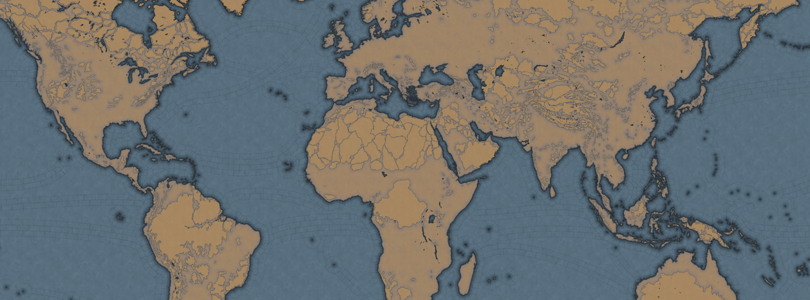

_9PYO04WeWxinmQ908H0ppIYzOEd8G2dr52m_sYlaiZCJTC9v8lfhYlwitil4ywR_ubig2b1QpP4bQA4ky64uRQ7K4kbdJ_04sVET3P9zxdJ6iSnlxfUVXloVVO2HyERtafi-H-gZJ3or_Mph8rpu-8


In most of our games set in the past, we have used the word of province for the smallest piece of clay on the map. However, with the map design we are doing for this game, it does not really thematically fit, as the map is more granular, and what people associate with a real-world province would not fit. So we went to a terminology we had used in the code since the first game we made in the old Europa Engine, which was “Location.”

So now our smallest subdivision is referred to as a Location, while a group of locations is a Province, and a group of provinces is an Area, and a group of areas is called a Region, and a group of regions is called a Subcontinent, and a group of subcontinents is called a Continent.

If we take the home of Paradox Interactive, it’s located in our location ‘Stockholm,’ which is in the province of ‘Uppland,’ which is in the “Svealand” area, which is in the “Scandinavia” region, which is part of the “Western Europe” sub continent, which is in the “Europe” continent.

Gre-y6NV8yptHswc5j9-UnVNHPeOEsitmYiVuF2SikujmPsgHVlYhIcfxqYxnFtOuZHuL6oOVwTkiLfLuZ4Mmvfr5q5rFx_pqKjXNd8ESvThSSUMVipKqnMPkr0_R9qJ_MkIp5Z6hkokcvqDF6RXNxg


Now you may wonder, why did we go with such granularity on a map like this? Well, this is entirely gameplay driven, from making a deep engaging gameplay peacetime possible, to better controlling the pacing of the game, and also to allow for more fun military campaigns.

We have tried to make provinces as historical as possible when it comes to borders, while trying to keep the size of the locations consistent, with a more or less regular progression from the smallest to the biggest, with our rule of thumb is that a location shouldn't have more than 3 times the number of pixels compared to a neighboring one.

So is the entire globe then divided into lots of tiny locations? No, as there are 4 types of locations, and for these we have taken heavy inspiration from the maps of Imperator and Victoria 3.

The first type of location is of the more uniform size. For a land location this would be the normal location that can be settled, and for a sea location, this would be a coastal sea location, or any location adjacent to a coastal sea location.

The second type is the “sea current” locations, which connect coastal areas with each other, allowing travel faster in 1 direction.
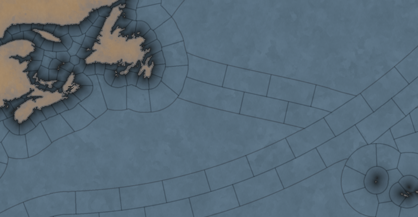
hxSrFrvpHBRP7C1FzL7yF3v_e1OeEsWIdkc4p9rQwiCUkYKRLlHjcghVclap33tUUDok0b-Bd1AACqYHvsCeVG25A1sKKd-5ua3cLsJVNJwQi-z9bpHG-IuM66UJwVBzg8ofGPX1_JE22mMiHS0y4nU


The third is what we call an “impassable wasteland,” which can be used to describe parts of Sahara, Greenland, or other places where hardly any people live even today. We also use these types for the majority of the water covering the oceans.

Finally, we have what we currently call “passages.” These are land locations that can not be settled by anyone, but can still be traversed by an army, with some insanely heavy attrition, or allow trade to pass through. Think of passages across the Saharan desert.

Speaking of desert... In a lot of our games we define each province as having a single terrain value, like Forest, Tundra, or Desert. This is rather limiting because eventually you end up with a huge list of complex things like “Arctic Forested Hill” or “Desert Mountain.” What we have done in Project Caesar is to take a deep look at how we did this in Victoria 2, where we had split terrain into topography and vegetation, and take it further. Now we have 3 different values in each location:

  • Climate - Includes things like Arid, Arctic, Continental, etc.
  • Topography - Flatland, Hills, Mountains etc.
  • Vegetation - Forest, Woods, Farmlands, Desert, etc.

What the actual gameplay impact of these is, we’ll talk about much later… Sorry.

Next week we’ll be back talking about something that could be rather controversial…
 
  • 267Love
  • 183Like
  • 16
  • 9
  • 2Haha
Reactions:
Is there going to be population system similiar to Imperator:Rome? And what about the building system in locations/provinces? Will they be on different levels? Such as locations have their own buildings like in Imperator, but provinces have their own kind of buildings/infrastructure buildings? I like playing tall/developing a nation, without having to go on world conquest.
 
  • 1Like
Reactions:
Welcome to the second week of Tinto Talks, where I talk about the design we have for our new top secret game, which we refer to as “Project Caesar.” Today we’ll delve into everyone's favorite topic, MAPS!

Let's begin with the projection we chose for this game. In the past we have used the Mercator or Miller projection which has some severe drawbacks, as you are all aware of. As we are restricted to a cylindrical map, we had to pick the least bad of them, which is why we went with the Gall Stereographic projection.

Why is that one good? Well, it keeps areas we care most about, those in the middle latitudes, bigger without making the poles ridiculously oversized or the equator too undersized. It also has a reasonable conformal shape, meaning that the shape of the continents stays the closest to their real areas and angles without sacrificing a recognizable shape of them.


_9PYO04WeWxinmQ908H0ppIYzOEd8G2dr52m_sYlaiZCJTC9v8lfhYlwitil4ywR_ubig2b1QpP4bQA4ky64uRQ7K4kbdJ_04sVET3P9zxdJ6iSnlxfUVXloVVO2HyERtafi-H-gZJ3or_Mph8rpu-8


In most of our games set in the past, we have used the word of province for the smallest piece of clay on the map. However, with the map design we are doing for this game, it does not really thematically fit, as the map is more granular, and what people associate with a real-world province would not fit. So we went to a terminology we had used in the code since the first game we made in the old Europa Engine, which was “Location.”

So now our smallest subdivision is referred to as a Location, while a group of locations is a Province, and a group of provinces is an Area, and a group of areas is called a Region, and a group of regions is called a Subcontinent, and a group of subcontinents is called a Continent.

If we take the home of Paradox Interactive, it’s located in our location ‘Stockholm,’ which is in the province of ‘Uppland,’ which is in the “Svealand” area, which is in the “Scandinavia” region, which is part of the “Western Europe” sub continent, which is in the “Europe” continent.

Gre-y6NV8yptHswc5j9-UnVNHPeOEsitmYiVuF2SikujmPsgHVlYhIcfxqYxnFtOuZHuL6oOVwTkiLfLuZ4Mmvfr5q5rFx_pqKjXNd8ESvThSSUMVipKqnMPkr0_R9qJ_MkIp5Z6hkokcvqDF6RXNxg


Now you may wonder, why did we go with such granularity on a map like this? Well, this is entirely gameplay driven, from making a deep engaging gameplay peacetime possible, to better controlling the pacing of the game, and also to allow for more fun military campaigns.

We have tried to make provinces as historical as possible when it comes to borders, while trying to keep the size of the locations consistent, with a more or less regular progression from the smallest to the biggest, with our rule of thumb is that a location shouldn't have more than 3 times the number of pixels compared to a neighboring one.

So is the entire globe then divided into lots of tiny locations? No, as there are 4 types of locations, and for these we have taken heavy inspiration from the maps of Imperator and Victoria 3.

The first type of location is of the more uniform size. For a land location this would be the normal location that can be settled, and for a sea location, this would be a coastal sea location, or any location adjacent to a coastal sea location.

The second type is the “sea current” locations, which connect coastal areas with each other, allowing travel faster in 1 direction.

hxSrFrvpHBRP7C1FzL7yF3v_e1OeEsWIdkc4p9rQwiCUkYKRLlHjcghVclap33tUUDok0b-Bd1AACqYHvsCeVG25A1sKKd-5ua3cLsJVNJwQi-z9bpHG-IuM66UJwVBzg8ofGPX1_JE22mMiHS0y4nU


The third is what we call an “impassable wasteland,” which can be used to describe parts of Sahara, Greenland, or other places where hardly any people live even today. We also use these types for the majority of the water covering the oceans.

Finally, we have what we currently call “passages.” These are land locations that can not be settled by anyone, but can still be traversed by an army, with some insanely heavy attrition, or allow trade to pass through. Think of passages across the Saharan desert.

Speaking of desert... In a lot of our games we define each province as having a single terrain value, like Forest, Tundra, or Desert. This is rather limiting because eventually you end up with a huge list of complex things like “Arctic Forested Hill” or “Desert Mountain.” What we have done in Project Caesar is to take a deep look at how we did this in Victoria 2, where we had split terrain into topography and vegetation, and take it further. Now we have 3 different values in each location:

  • Climate - Includes things like Arid, Arctic, Continental, etc.
  • Topography - Flatland, Hills, Mountains etc.
  • Vegetation - Forest, Woods, Farmlands, Desert, etc.

What the actual gameplay impact of these is, we’ll talk about much later… Sorry.

Next week we’ll be back talking about something that could be rather controversial…
Cool! You got me wondering— will we ever get a game on a globe?
 
  • 1
Reactions:
What are you waiting for? The longer you wait, the higher the chance it will be too late.
If the game covers Age of Discovery, subsequent Colonization and Globalization, its only fair that the pioneers of such events get represented accurately.

I don't want to see Portugal going "it's free real estate" on every empty province of the map.
It was a small country with a small population that relied on fleets factories and fortresses to hold an Empire from Macau to Rio.

But alll in due time.
 
  • 3Like
Reactions:
If individual locations can be independent then this will be Voltaire's 5mare. I'm so excited for Project Caesar.

Edit: I love the changes to how sea tiles work, but I hope certain rivers/lakes are navigable like in CK3. My picks for navigable rivers and lakes wouldbe:

South/Southeast Asia: Ganges, Indus, Brahmaputra and the Mekong.

East Asia: Yellow River, Yangtze, Qiantan, Pearl, and several lakes that these rivers merge with, also Tokyo, Osaka, Iso and Seoul bays (including the Han River).

Central Aisa: Aral Sea, Lake Baikal and Lake Balkhash.

Middle East: The Tigris and Euphrates.

Africa: Nile (including the White and Blue Niles, Lake Victoria and the surrounding lakes, Niger, Congo (only some of it though) and Lake Volta in Ghana.

Europe: Rhine, Danube, Volga, Don, Dnieper, Thames, Lake Ladoga And Onega, Guadalquivir, Tabus river and bay, Venice Lagoon (including Venice not being 10x it's actual size), Stettin Lagoon, also several fjords and lakes in Scandinavia

America: Parts of the Amazon, Straight of Magellan, Lake Maracaibo, Mississippi, St. Laurence and the Great lakes. Nelson River, Vancouver and Seattle bay areas and the San Francisco Bay Area and the Sacramento River.

This would truly make the map of Prpject Caesar perfect. As many Naval battles actually happened on rivers and lakes. One of the biggest battles in the Crusade of Varna was fought on the Danube River. Resulting in a decisive Ottoman Naval victory.
 
Last edited:
  • 1
Reactions:
The amount of impassable wasteland is going to make combat interesting.
 
  • 1
Reactions:
Welcome to the second week of Tinto Talks, where I talk about the design we have for our new top secret game, which we refer to as “Project Caesar.” Today we’ll delve into everyone's favorite topic, MAPS!

Let's begin with the projection we chose for this game. In the past we have used the Mercator or Miller projection which has some severe drawbacks, as you are all aware of. As we are restricted to a cylindrical map, we had to pick the least bad of them, which is why we went with the Gall Stereographic projection.

Why is that one good? Well, it keeps areas we care most about, those in the middle latitudes, bigger without making the poles ridiculously oversized or the equator too undersized. It also has a reasonable conformal shape, meaning that the shape of the continents stays the closest to their real areas and angles without sacrificing a recognizable shape of them.


_9PYO04WeWxinmQ908H0ppIYzOEd8G2dr52m_sYlaiZCJTC9v8lfhYlwitil4ywR_ubig2b1QpP4bQA4ky64uRQ7K4kbdJ_04sVET3P9zxdJ6iSnlxfUVXloVVO2HyERtafi-H-gZJ3or_Mph8rpu-8


In most of our games set in the past, we have used the word of province for the smallest piece of clay on the map. However, with the map design we are doing for this game, it does not really thematically fit, as the map is more granular, and what people associate with a real-world province would not fit. So we went to a terminology we had used in the code since the first game we made in the old Europa Engine, which was “Location.”

So now our smallest subdivision is referred to as a Location, while a group of locations is a Province, and a group of provinces is an Area, and a group of areas is called a Region, and a group of regions is called a Subcontinent, and a group of subcontinents is called a Continent.

If we take the home of Paradox Interactive, it’s located in our location ‘Stockholm,’ which is in the province of ‘Uppland,’ which is in the “Svealand” area, which is in the “Scandinavia” region, which is part of the “Western Europe” sub continent, which is in the “Europe” continent.

Gre-y6NV8yptHswc5j9-UnVNHPeOEsitmYiVuF2SikujmPsgHVlYhIcfxqYxnFtOuZHuL6oOVwTkiLfLuZ4Mmvfr5q5rFx_pqKjXNd8ESvThSSUMVipKqnMPkr0_R9qJ_MkIp5Z6hkokcvqDF6RXNxg


Now you may wonder, why did we go with such granularity on a map like this? Well, this is entirely gameplay driven, from making a deep engaging gameplay peacetime possible, to better controlling the pacing of the game, and also to allow for more fun military campaigns.

We have tried to make provinces as historical as possible when it comes to borders, while trying to keep the size of the locations consistent, with a more or less regular progression from the smallest to the biggest, with our rule of thumb is that a location shouldn't have more than 3 times the number of pixels compared to a neighboring one.

So is the entire globe then divided into lots of tiny locations? No, as there are 4 types of locations, and for these we have taken heavy inspiration from the maps of Imperator and Victoria 3.

The first type of location is of the more uniform size. For a land location this would be the normal location that can be settled, and for a sea location, this would be a coastal sea location, or any location adjacent to a coastal sea location.

The second type is the “sea current” locations, which connect coastal areas with each other, allowing travel faster in 1 direction.

hxSrFrvpHBRP7C1FzL7yF3v_e1OeEsWIdkc4p9rQwiCUkYKRLlHjcghVclap33tUUDok0b-Bd1AACqYHvsCeVG25A1sKKd-5ua3cLsJVNJwQi-z9bpHG-IuM66UJwVBzg8ofGPX1_JE22mMiHS0y4nU


The third is what we call an “impassable wasteland,” which can be used to describe parts of Sahara, Greenland, or other places where hardly any people live even today. We also use these types for the majority of the water covering the oceans.

Finally, we have what we currently call “passages.” These are land locations that can not be settled by anyone, but can still be traversed by an army, with some insanely heavy attrition, or allow trade to pass through. Think of passages across the Saharan desert.

Speaking of desert... In a lot of our games we define each province as having a single terrain value, like Forest, Tundra, or Desert. This is rather limiting because eventually you end up with a huge list of complex things like “Arctic Forested Hill” or “Desert Mountain.” What we have done in Project Caesar is to take a deep look at how we did this in Victoria 2, where we had split terrain into topography and vegetation, and take it further. Now we have 3 different values in each location:

  • Climate - Includes things like Arid, Arctic, Continental, etc.
  • Topography - Flatland, Hills, Mountains etc.
  • Vegetation - Forest, Woods, Farmlands, Desert, etc.

What the actual gameplay impact of these is, we’ll talk about much later… Sorry.

Next week we’ll be back talking about something that could be rather controversial…
Hey Johan, awesome project. Congratulations to the whole Tinto team.
My question is, would it be possible to know the (approximate) number of locations - or at least the number of provinces - that you plan to include in the game? Thank you very much!
 
  • 1Like
Reactions:
Will you be able to own or claim wasteland tiles? It makes sense that you can't just walk your troops across the Alps or the Pyrenees but I think that it should still be possible for Spain or France to own the Pyrenees, or Savoy, the Swiss Confederacy, Austria, etc. to own parts of the Alps. Obviously if you encircle a wasteland with your territory you will probably own it but I am thinking of cases where there is a wasteland between two countries.
 
Regarding the sea current locations as shown on the world map - if we assume this is sometime during an age of sail (given that we have intercontinental routes), there are likely a few routes missing from the currents, such as Cape Verde-Brazil/La Plata, and ocean-going routes from the English Channel to South Africa. The route from Britain to the US East Coast should probably go south of Ireland/towards the English Channel (which would also catch routes from Brittany and the Netherlands to the East Coast).

Obviously catching every case including routes that would be used by alternate history polities is not possibly without reverting to "the whole ocean consists of provinces(locations)" but there are some 'obvious' routes that seem to be missing (depending on what the time frame actually is, of course, but considering the presence of global sea routes...)

Here's a quick visualization based on a dataset discussed here and visualized dynamically here.
From those visualizations I actually think the biggest missing routes are Cape of Good hope <---> Straight of Malacca passing south of Madagascar. It seems one of the most prominent routes IRL, but not possible on this map.

Meanwhile, we have that Australia <---> North of Madagascar lane that seems absent in the historical data. Might as well scrap it to make place for those others?

The routes in the Atlantic can be somewhat approximated by the current setup I think. Though you are right, it could probably be improved by centring the routes a bit more strictly on Cape Verde, and adding an Azores <---> Cape Verde Lane curving through the open ocean.

I wonder if Johan can discuss the reasoning behind the choice of sealanes yet. Is it purely from historical data? Or also theoretical possibilities from real currents that went unused?
 
  • 2Like
  • 1
Reactions:
Add Guadalquivir to that list. With the granularity of the map, Seville wouldn't be at the coast like in EU4.
Fair point, Sevilla was the main port city in Spain and served as a hub for the transatlantic slave trade. I'll also add the Tagus river as much of Lisboa is on the Tagus bay.
 
  • 2Like
Reactions:
it would only be controversial if mana stays. let's hope that's not the case...
Johan mentioned once that there will be no Paradox Game ever without Mana.

Edit: The reference:

2024-03-07.png
 
Last edited:
  • 10
  • 1
Reactions:
A one word answer with a lot of information contained within.

If a location can be a tag, it means that locations must be able to support buildings and other infrastructure to generate an economy.

But if all locations were able to support infrastructure, we could have hundreds or even thousands of locations within our empires we would have to manage. It would in fact be unmanageable and meaningless. One of the problems I felt EU4 has is that there are simply too many provinces, interacting with so many after a certain point became meaningless. Victoria 3 in contrast uses states, which I think would be the equivalent of areas in this game, meaning you have fewer map areas to interact with but those states have more meaning as a result.

I have to assume that if you have 3 locations in a province, you'll manage the infrastructure in that province at the province level and not the location level.

I am interested in seeing what the relationship is between locations, provinces and areas and whether there is an appropriate divison of focus to enable better, more meaningful Empire management. Lumbering everything onto the province level in EU4 was what was done then, but I think if meaningful interaction can be uploaded to the Area level (like souped up states), that would greatly streamline play. I don't know about you, but using a UI to build dozens of buildings in dozens of provinces simply to burn ducats was not a satisfying interaction for me. I would have much preferred developing Svealand, as an example, as a dedicated port region and home to my navy.
 
  • 1
Reactions: