• We have updated our Community Code of Conduct. Please read through the new rules for the forum that are an integral part of Paradox Interactive’s User Agreement.

Tinto Maps #10 - 12th of July 2024 - Syrian Levant & Egypt

Hello everyone, and welcome to another Tinto Maps! We’re back after celebrating the most important victories over Germany and France since the 30 Years War a hard week of work, and we’re ready to share with you the region of the Syrian Levant & Egypt (actually, we’re revealing a bit more of what those regions would be, to cover the complete extension of the Mamlūk Sultanate). Let’s go!

Countries:
Countries.png

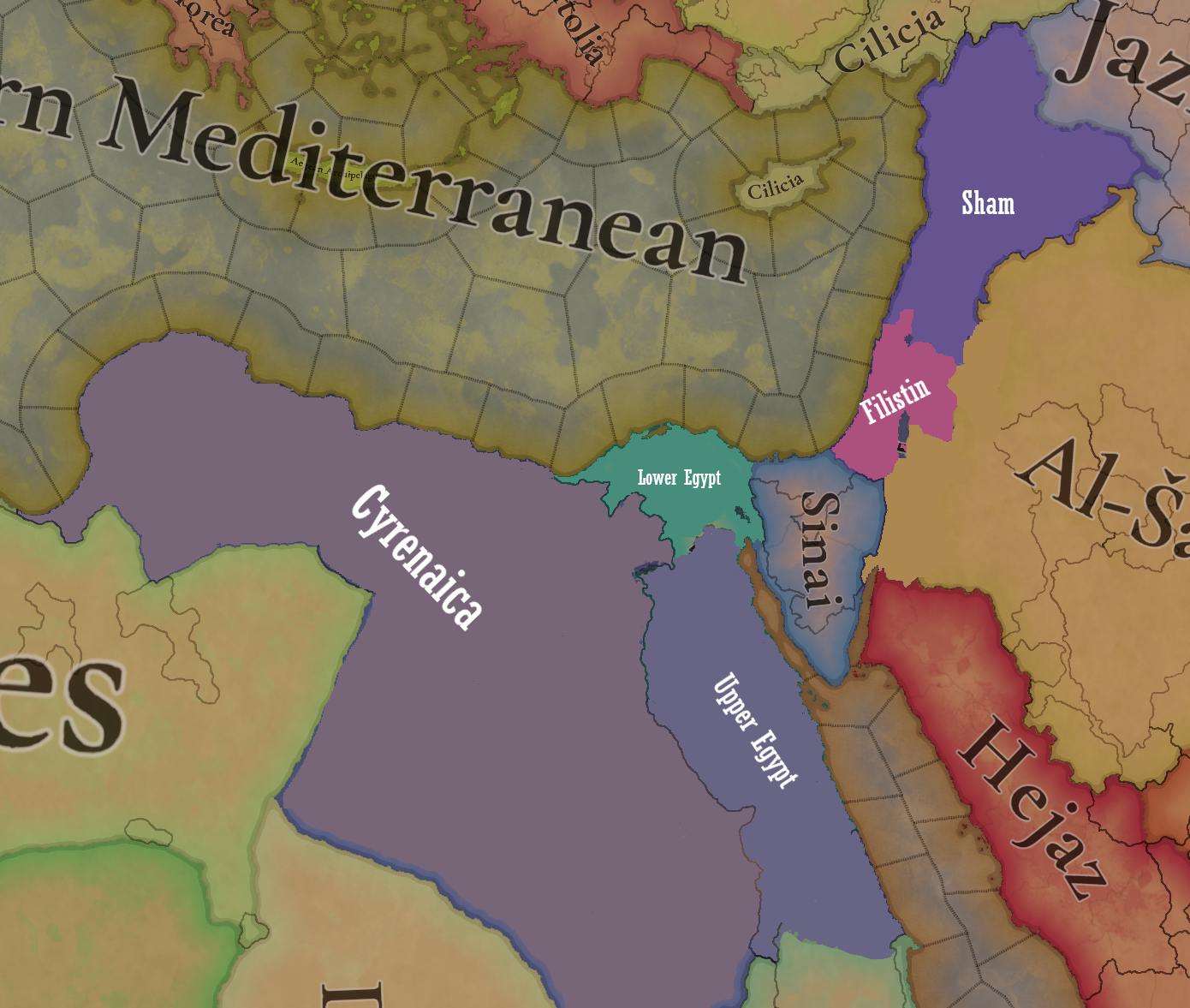
The Mamlūk Sultanate is the main power of the region, a situation achieved after the defeat of the Mongols at the Battles of Ain Jalut and Marj al-Saffar, and the fall of Acre, the last stronghold of the Crusader states in Outremer. The latter's legacy is still handled by the Kingdom of Cyprus, ruled by Hugues IV of Lusignan. Apart from that, we can see the realm of Candia, a subject governed by the Serene Republic of Venice, and some Arabic tribes, such as the Hutaym and the Anizah. Oh, and also, to the south-west, you might have noticed some oases ruled by either the Mamluks, or Fezzan; I opted for not coloring the wastelands, as usual, but also the corridors, a type of terrain present in other GSGs, that we have in Project Caesar. I’ll talk more about them under the ‘Locations’ section of the DD, but I just want to note one more thing: the connection down the Nile is a regular one, with a border existing between the Mamluks and Makuria (the country that controls the small chunk of land at the very south of the image).

Dynasties:
Dynasties.png

The Bahri Mamluks have ruled the Sultanate since they deposed the Ayyubids, almost a century before the start of the game. It could maybe be a bit more accurate to depict Sultan al-Nasir Muhammad as an ibn Qalawun (‘of the lineage of Qalawun’), but the dynastical dynamics of the Mamluk rulers are not so easy to portray, so we opted for the moment to better use Bahriyya. Apart from that, you may also see the neighboring dynasties, such as the already-mentioned House of Lusignan, or the Hethumian of Cilicia.

Locations:
Locations 1.png

Locations 2.png

Locations 3.png

Locations 4.png
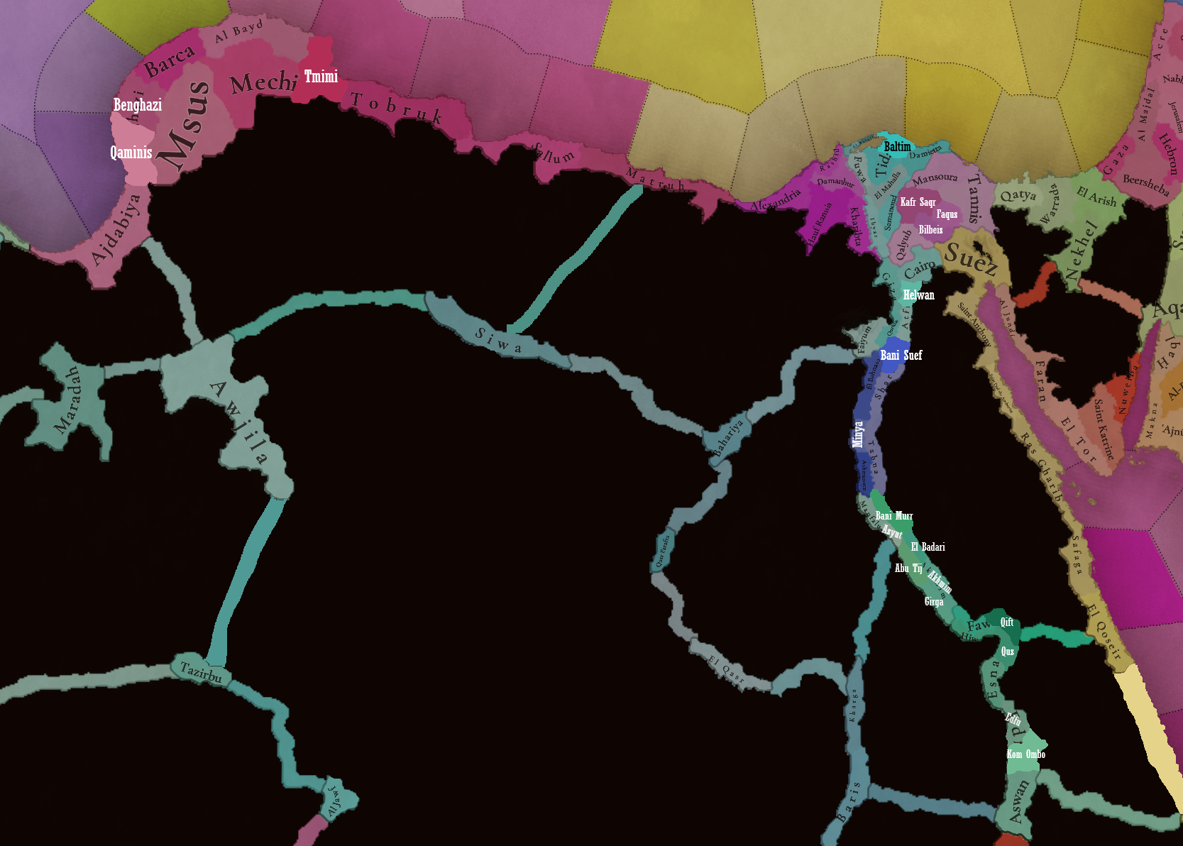
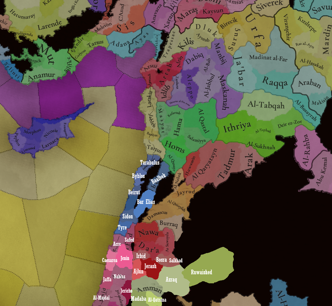
Here you can see the locations of the entire region, and also closer chunks behind the ‘Spoiler’ button. The most interesting feature to talk about is that of the corridors, something that some of you might remember from ‘Imperator: Rome’, but also something new to the rest. The corridors are empty locations, with no population or resources, but that allows connection between the locations at their sides, for some mechanics that we’ve already mentioned (market access, control), and some others that we haven’t (army movement). This is the way that we’ve chosen to portray the Saharan corridors, that allow for a connection between the Maghreb and the Mashreq, and Western and Central Africa. There are also some regular locations over those corridors, with population, resources, etc., that can be controlled by countries, which portray the desert oases that made for important outposts in the different Saharan routes. Not all the connections are throughout corridors, though; outside of the image, the Nile River valley allows for regular locations all the way down from Egypt to Nubia, the last location held by the Mamluks being that of Aswan, while the first held by Makuria, not shown in the screenshot, being Qasr Ibrim. We will talk more about Nubia and Ethiopia in a future Tinto Maps.

Provinces:
Provinces.png

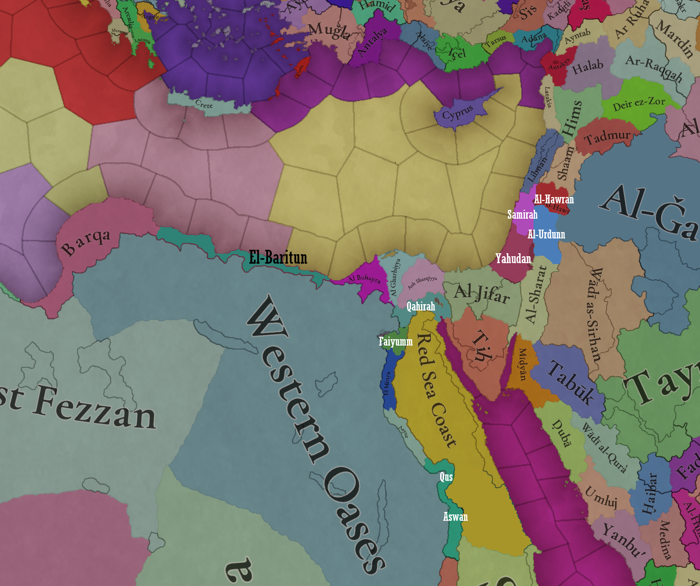
Usual provinces mapmode; please let us know of any spelling or naming suggestions that come to your mind.

Areas:
Areas.png

A new mapmode that has been requested in previous Tinto Maps, and that we’re now incorporating.

Terrain:
Climate.png

Topography.png

Vegetation.png

The climate is dominated by a mix of Mediterranean, Arid, and Cold Arid. The topography of the region is quite flat, with some hills and mountains on Mount Lebanon and Anti-Lebanon, Mount Sinai, and the verge of the Arabian plateau; and some marshland over the Nile Delta, of course. Regarding the vegetation, desert and sparse vegetation dominate most of the region, with some woods and forests over Levant, and the Nile fertile farmlands, the bread basket of the Eastern Mediterranean.

Cultures:
Cultures.png

Here starts the fun… Those countries ruling over the Middle East will face the challenge of managing several different cultural minorities. Libyan, Egyptian, Sa'idi, Bedouin, Ḥijāzī, Najidi (the green one to their right), Levantine, and Iraqi (the light blue at the top right of the picture) are all different regional cultures of Arabic-speaking people. Something interesting is that most of Bedouin pops are tribesmen, instead of peasants, portraying their traditional social organization. Coming to important minority groups, Coptic people are quite important in Egypt, accounting for about 10% of the population of the Mamlūk Sultanate. The other important minority are the Syriacs, as they also account for another 10% of the population, and are a cultural majority in a few locations. Apart from those, there are also Armenians, Kurds, and Turkomans on the divide between Anatolia, Syria, and Jazira, Alawites Shiites in Syria, Mizrahi Jews all over the region, Samaritans in Palestine, and Greeks in Crete, Cyprus, and some in Alexandria. Oh, also the Saharan cultures of the Eastern Berbers and the Toubou over some of the Saharan oases.

Religions:
Religion.png

More fun. In this region, we have:
  • Sunni Muslims
  • Miaphysite Christians
  • Orthodox Christians
  • Shia Muslims
  • Catholic Christians
  • Druzes
  • Jews
  • Nestorian Christians (the ‘label’ we’re using to depict the Church of the East)
  • Samaritans
  • Yazidi

Relating these religions to the previous cultures, we can tell you most of the Arabic-speaking cultures are Sunni Muslims, with some Shia Muslims in Syria and Lebanon. Most of the Coptic are Miaphysite, adhering to the Patriarchate of Alexandria, although some of there still follow the Orthodoxy of Constantinople. The Syriacs are also religiously divided, with some being Nestorians (the current name we have to cover the confessions related to the Church of the East), some Miaphysites, some Orthodox, and even some Catholics in Lebanon. And then we have some cultural-religious minorities, such as the Alawite Shiites, the Druzes (which are of Levantine culture), the Mizrahi Jews, the Samaritans, and the Yazidi (which are of Kurd culture).


Raw Materials:
Raw Materials.png

There are some materials that are more unique to this region, such as the Dates in the arid fringes. The Nile Valley and Delta are incredibly fertile, having plenty of different crops: Wheat, Rice, Legumes, Sugar, Cotton, Fiber Crops (=Linen), etc. Livestock, Wool, and Horses are also important resources for the people across the region. There are also some metals present in the region, such as Copper in Cyprus and around the Red Sea, Iron, Tin, some Lead, and some interesting sources of Alum.

Markets:
Markets.png

The main market centers of the region are Alexandria (yeah, it’s there! I’ve already reported its weird name-wrapping and one of our programmers is going to take a look at it) for the Mashreq, Damascus for the Syrian Levant and Mecca for the Hejaz.

Country and Location Population:
Country Population .png

Location Population 1.png

Location Population 2.png

Location Population 3.png
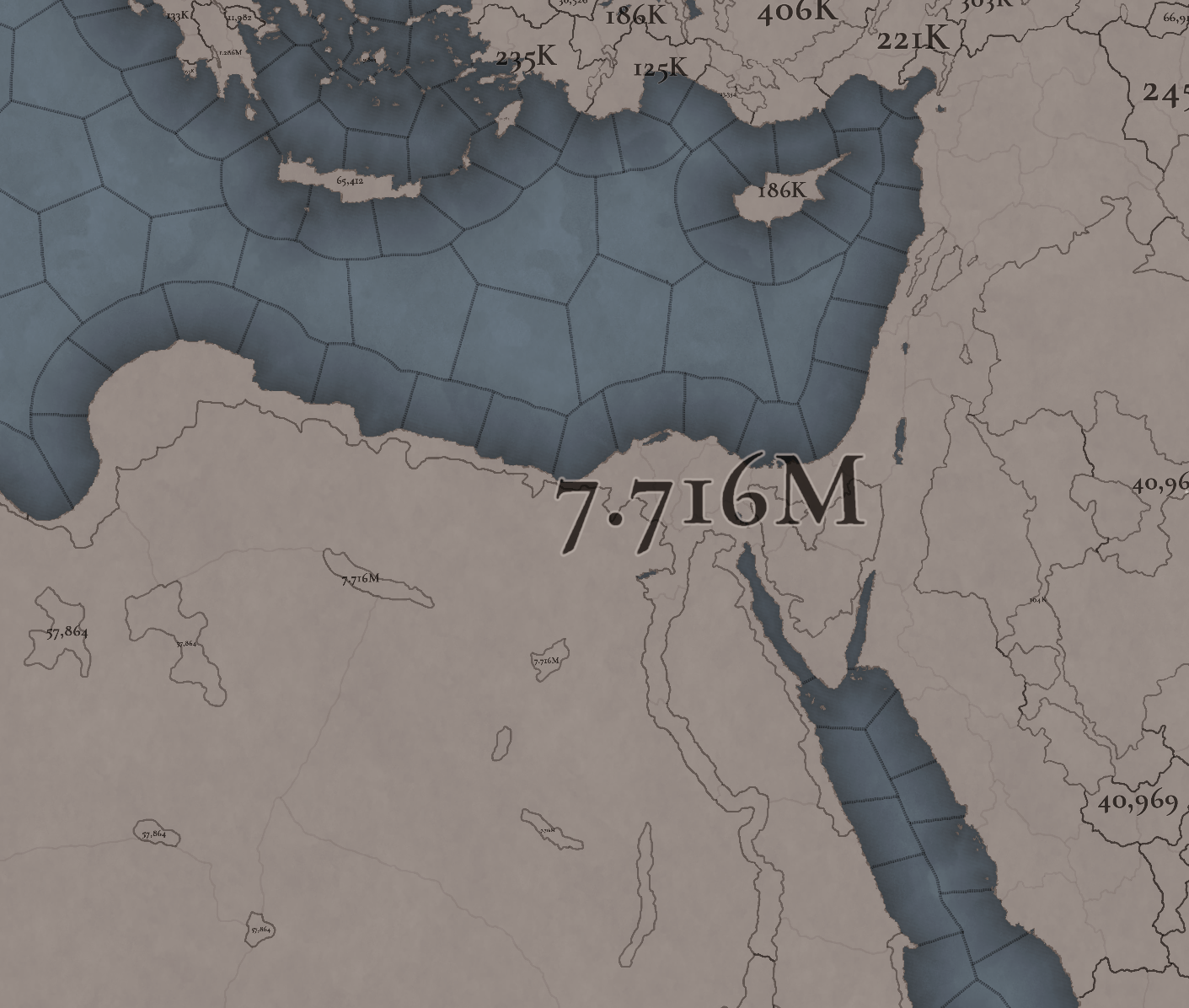
The population of the region points to Egypt being its powerhouse, with several million people being supported being the Nile Valley and Delta. Apart from that, the Syrian Levant has a very decent population, making the Mamlūk Sultanate a dreadful rival to have in 1337. The arid fringes make for a way more difficult food production and population sustainability, making them more of strategic value, by their position, resources, etc.

And that’s all for today! Next week @Johan will show you Scandinavia, the very first map that was crafted for Project Caesar! Cheers!
 
  • 176Like
  • 54Love
  • 7
  • 4
  • 4
  • 1Haha
Reactions:
"Mizrachi" is indeed a bit of an overinclusive neologism, but I don't mind its use here, especially when you have other terms like "Eastern Berber" as a single culture. The other option would be splitting Mizrachi into 5 or even more different cultures, and the Jewish group already has a lot of granularity.
I think it makes perfect sense for Jews to be seperated into numerous subcultures, as at this point in history Jews would have cultural and linguistic similarities to the countries they lived in. This would give us the benefit of having cultural similarities between Jews and non-Jews in certain countries, and also to have a better portrayal of the cultural dynamic of the Jewish world (we could see Sefardics migrating everywhere after being expelled for example).
It might seem like a lot of cultures but I think it works better than making Jews have very broad and undefined supercultures, or to have some Jews have a unique culture while others have the same culture as their surroundings. I believe the game should have some kind of ethnoreligions mechanic which would tie certain religions to their own cultures, preventing them from spreading to other cultures, and Judaism would be such a religion.
We don't need 5 different Mizrachi cultures tho.
Jewish cultures can amount to:
  • Ashkenazi - Jews in northern, central, eastern Europe
  • Sefardi - Jews in Iberia
  • Italki - Jews in Italy (already confirmed in the Italy Tinto Talks)
  • Romanyoti - Jews in Greece and Anatolia (already confirmed in the Balkans Tinto Talks)
  • Krymchak - Jews in Crimea
  • Musta'arabi - Jews in the Maghreb, Egypt, Levant and Mesopotamia
  • Teimani - Jews in Yemen (can be folded into Musta'arabi maybe?)
  • Beta Israel - Jews in Ethiopia
  • Iranian Jews - Jews in the Persian region, Bukhara and the Caucasus
  • Kochini - Jews in Cochin (India)
 
  • 17Like
  • 1
Reactions:
red location: was very lightly inhabited/able in 14th century (2 of the three towns had been abandoned for centuries by then). The Alexandria canal passed more north, it could definitely be argued that its borders were the limit of civilization. The current city only makes sense in the age of the automobile.
Yes 2 of the three main towns were abandoned in the 14th century, but the remaining town was very much still standing. Making the location sparsely populated, but populated none the less. The population of the region would also increase from the 14th century onwards. So including the location makes far more sense than not including it.
blue location: locations in this region definitely are too large, Saqqara seems to be intended part of Gizeh, should definitely be separated out (though definitely less connected than in your proposal)
Actually the location I proposed doesn't include Saqqara, it's specifically the desert west of Saqqara. Which was sparsely populated but significant as it was (sadly) a great source of stone for the nearby cities. The location probably shouldn't be called Saqqara though, maybe Djoser or West Saqqara?
green location: this one is really basically nothing (today), with the added (for me huge) disadvantage of making Fayoum less of a special place. From wiki, the monastery was largely abandoned within about a century of game start... Wadi al rayan could be made part of a "West Fayoum" location
According to Wikipedia the monastery was actually at its peak during the 13th and 14th centuries, with it perhaps being inhabited all the way to the 17th century. I do agree that it does take away from Faiyum a bit, so I've redrawn the border so that it only borders Faiyum, meaning that Faiyum is the only way to get to apart from the passage to Bahariya.

IMG_3968.jpeg


Old border in red, new border in yellow.
 
Last edited:
  • 6Like
Reactions:
I think it makes perfect sense for Jews to be seperated into numerous subcultures, as at this point in history Jews would have cultural and linguistic similarities to the countries they lived in. This would give us the benefit of having cultural similarities between Jews and non-Jews in certain countries, and also to have a better portrayal of the cultural dynamic of the Jewish world (we could see Sefardics migrating everywhere after being expelled for example).
It might seem like a lot of cultures but I think it works better than making Jews have very broad and undefined supercultures, or to have some Jews have a unique culture while others have the same culture as their surroundings. I believe the game should have some kind of ethnoreligions mechanic which would tie certain religions to their own cultures, preventing them from spreading to other cultures, and Judaism would be such a religion.
We don't need 5 different Mizrachi cultures tho.
Jewish cultures can amount to:
  • Ashkenazi - Jews in northern, central, eastern Europe
  • Sefardi - Jews in Iberia
  • Italki - Jews in Italy (already confirmed in the Italy Tinto Talks)
  • Romanyoti - Jews in Greece and Anatolia (already confirmed in the Balkans Tinto Talks)
  • Krymchak - Jews in Crimea
  • Musta'arabi - Jews in the Maghreb, Egypt, Levant and Mesopotamia
  • Teimani - Jews in Yemen (can be folded into Musta'arabi maybe?)
  • Beta Israel - Jews in Ethiopia
  • Iranian Jews - Jews in the Persian region, Bukhara and the Caucasus
  • Kochini - Jews in Cochin (India)
You're forgetting the Shúhū (Chinese) and Kurdi (from Kurdistan, albeit they speak Aramaic, rather than Kurdish) Jews, as well as the Bene Israel of India. You could probably also split "Iranian Jew" into Kalimi, Kavkazi, and Bukhari.
Honestly one of the reasons I'm fine with "Mizrachi" existing as a wastebasket for "Jews in the Muslim World" (besides the fact that it's a useful umbrella term) is, assuming Israel/Judea is a releasable/formable, it'd be kind of weird to have "Mustaaravi" as its primary culture, no?
 
Last edited:
  • 6Like
  • 3
  • 2
Reactions:
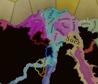
I don't think that the wastelands west of the Nile should reach all of the way to the Nile. Many important towns and inhabited locations are currently shown as wastelands; despite some of them being not only inhabited, but extremely important.

View attachment 1163334

I think these 3 highlighted regions should be made locations, for several reasons that I'll go through location by location.

The Red location is Natrun, which should be a majority Coptic, sparse flatlands location with an arid climate. The land is arable today, but that is mostly due to modern irrigation projects. It was more arid in the 14th century, although not fully a desert so I'd classify it as sparse. Modern day El Sadat city is also within the location, which although a modern city does show that the region is inno way uninhabitable. The population would be majority Copts due to it's remote and arid nature. Which made it a hub for Coptic monastic communities to thrive in the region.

The blue location is Saqqara, which I expect many have heard of. For those who haven't, it was an Ancient Egyptian complex which included the Saqqara necropolis and many famous pyramids only a few kilometres south. Although the valley used to be much more stable when the necropolis was built, it was mostly dessert by the 14th century. Except for the very eastern fringes of the location, which could sustain some agriculture due to being on the fringes of the Nile valley. Also yes the Saqqara region was still inhabited at this time, with small settlements springing up in some of the only arable areas and along a few caravan routes. For these reasons I would classify the location as being desert, as there was very little agriculture. But it certainly wasn't a wasteland, as it could sustain human settlement.

The yellow location is Qalamun, famous for housing the monastery of Saint Samuel the Confessor. Similar to Natrun it was a centre for Coptic monasticism in the harsh landscape. Though it was much harsher than Natrun, which is why I would classify it as desert. The region also has a fair few hills, so I would make it hills instead of flatlands. I've also included the lake of Wadi El Rayan and the surrounding hills in the location, as they were also used for similar monastic reasons. Because of its monasticism I would make it majority Copt, with very few Masri in the location. The passage to Bahariya should also be changed so that it's a Qlamun-Bahriya passage, as it wouldn't make much sense for the passage to connect to Faiyum.

Overall there should just be some more locations west of the Nile, as these areas were and are still inhabited. They lie on the fringes of the Nile, where the lush valley meats the harsh dessert. Because of this they were inhabited and settled, despite the wastelands which live just to their west.
Locations are named after inhabited villages, towns, cities and castles/fortresses, though. The location-names you propose are neither of those, though. The red one might be possible, as you mention there being some towns.
 
The Lebanon province could probably be broken up, as the division shown here is very modern. Historically "Mount Lebanon" was considered to consist of the in-game locations of Beirut and Byblos. If they add one more location to it like you've done here, the Becaa Valley could be its own province, Tripoli could go to Latakia, the southern locations maybe could be grouped with Palestine as part of the Galilee (al-Jalīl), with the remainer of the Palestine province renamed to "Judea and Samaria" (al-Quds in Arabic, alternatively they could be two separate provinces, but I don't think the Arabs used the terms "Samirah" and "Yehudan" to refer to the region outside of an historical context).
 
Last edited:
  • 3
  • 1Like
  • 1
Reactions:
Caesarea was a ruin at this time id suggest making the southern province Haifa(it needs to consist that tiny peninsula tho)
Haifa was just a small fishing village until Zahir al-Umar demolished it and rebuilt it a bit to the east as a port-city. To be fair, I think Jaffa was also just a small fishing village at this time, so it might merit inclusion regardless.
 
  • 3Like
  • 1
Reactions:
Locations are named after inhabited villages, towns, cities and castles/fortresses, though. The location-names you propose are neither of those, though. The red one might be possible, as you mention there being some towns.
Qalamun and Natrun are both the largest town in their respective locations. Djoser isn't a town it's a pyramid, but there honestly isn't a better name for the location. Also Natrun is sometimes called Scetis or Skete.
 
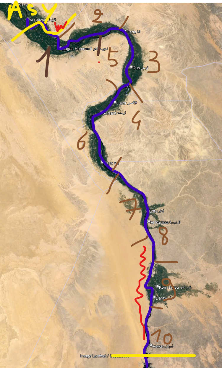
Continuing from posts 384/387 : Aswan province (wouldn't Luxor be a better name ?)

River should be really important, so :

1) Hiw (does not seem the logical name, but it's the one Tinto used...)
2) Faw
3) Qift (Qus seems only third choice for name, with Qift the historical and Qena the modern city connecting with the red sea)
4) Luxor
5) Naqadah
6) Esna (might be cut in two still)
7) Edfu
8) An Nuzul (name ?)
9) Kom Umbu
10) Aswan

yellow = other provinces, bleu = Nile, red = impassable, brown = location borders

1720979298048.png


It might be argued that the northern and southern bits of 8 should be impassable, but that would break the "land connection to Ethiopia" goal.
7, 8 and 10 desert, 9 and 5 probably arid, the rest farmland

I'll also edit some small remarks into the previous posts. (size of locations, not everything should be farmland, from dualninja's post - the left bank inhabited zone is kinda wide north and south of Minya)
 
Last edited:
  • 1
Reactions:
Caesarea was a ruin at this time id suggest making the southern province Haifa(it needs to consist that tiny peninsula tho)
That's fair, I chose Caesarea since like many coastal fortified towns, were nearly completely uninhabited after the mamluks took over, including Haifa, so I just opted for one in between Jaffa and Acre, as all the towns started repopulating over the 15th and 16th centuries. Though upon a closer look, Haifa started to regain its importance during Ottoman rule, while Caesarea remained small and relatively unimportant until the 1800s, so perhaps Haifa is still the better choice here :)
 
  • 3Like
  • 3
  • 1
Reactions:
Caesarea was a ruin at this time id suggest making the southern province Haifa(it needs to consist that tiny peninsula tho)
Haifa, Ascalon, Caesarea, Acre, Atlit, Jaffa and others were ruined and completely devestated by the Mamluk sultan Baibars when he conquered the kingdom of Jerusalem 100 years before game start.
Some of these towns were completely destroyed and abandoned and others survived in the form of fishing villages, with most of their houses and fortifications destroyed. It wouldn't make sense to have such towns on the coast be separete locations - what the devs did with the "Acre" and "Al-Majdal" locations actually makes sense.
 
  • 1
Reactions:
Haifa, Ascalon, Caesarea, Acre, Atlit, Jaffa and others were ruined and completely devestated by the Mamluk sultan Baibars when he conquered the kingdom of Jerusalem 100 years before game start.
Some of these towns were completely destroyed and abandoned and others survived in the form of fishing villages, with most of their houses and fortifications destroyed. It wouldn't make sense to have such towns on the coast be separete locations - what the devs did with the "Acre" and "Al-Majdal" locations actually makes sense.
Having some fishing villages in the game isn't necessarily a bad thing. Villages are allowed. The question is, which make the most sense to include?
 
  • 5
Reactions:
Having some fishing villages in the game isn't necessarily a bad thing. Villages are allowed. The question is, which make the most sense to include?
The question isn't whether to include fishing villages in the game, its to make a tiny location that only corresponds to that village, that's what doesn't make sense to me.
Atlit, Caesarea and Ascalon were completely wiped out.
Jaffa survived but in a very diminished form and it shouldn't constitute a separate economic location from other rural towns in its area such as Ramla and Al-Majdal. It was certainly less important than these two.
Acre and Haifa were turned from fearsome fortified cities into small villages and were only restored during the late Ottoman period. Anyway those two are so close that it was always one of them that was prospering at the expense of the other so they should also be in the same location.
 
  • 2
  • 1Like
  • 1
Reactions:
The question isn't whether to include fishing villages in the game, its to make a tiny location that only corresponds to that village, that's what doesn't make sense to me.
Atlit, Caesarea and Ascalon were completely wiped out.
Jaffa survived but in a very diminished form and it shouldn't constitute a separate economic location from other rural towns in its area such as Ramla and Al-Majdal. It was certainly less important than these two.
Acre and Haifa were turned from fearsome fortified cities into small villages and were only restored during the late Ottoman period. Anyway those two are so close that it was always one of them that was prospering at the expense of the other so they should also be in the same location.
I can definitely get behind that reasoning.
 
Haifa, Ascalon, Caesarea, Acre, Atlit, Jaffa and others were ruined and completely devestated by the Mamluk sultan Baibars when he conquered the kingdom of Jerusalem 100 years before game start.
Some of these towns were completely destroyed and abandoned and others survived in the form of fishing villages, with most of their houses and fortifications destroyed. It wouldn't make sense to have such towns on the coast be separete locations - what the devs did with the "Acre" and "Al-Majdal" locations actually makes sense.
However you also have to take into account the growth of 500 years into the locations, not to mention we have 3 levels of urbanization anyway to reflect the effects of either population growth or depopulation (rural/villages, towns, cities). Jaffa for example was recorded as a busy center in 1321, but in the 1400s was a small village, 1500s was basically uninhabited, and 1600s it started experiencing growth again, intensifying in the 1700s. So many villages and cities have gone through periods of non-existence, to major centers of trade and science and manufacturing, and some back to near non-existence. I think the more important aspect to consider is if the location has had at least a consistent presence in it or around it (thus rural levels of locations)

EDIT: If coastal villages of the time still aren't the way to go, Jaffa and Ceasarea can be turned to Ramleh and Tulkarm respectively
 
Last edited:
  • 3
  • 1
Reactions:
Now that I think about it, there were a lot of these "nominally an integral part of the Ottoman Empire but in practice functionally independent" states throughout history, Muhammad Ali's Egypt, Zahir al-Umar's Galilee, etc. I wonder how they'll be represented. Rebels? A special kind of vassal? Whatever the situation calls for?
I do assume it's the last
The region was known as "Syria-Palestine" to westerners for over a millenium at that point, but I think the Arabs might've just called it "North Sham" and "South Sham". Filasṭīn was indeed used as a name for the southern Levant, but Sūriya is I think a neologism.
I would be happy with any name but I do think this is just too large compared to other areas
I was responding to someone else, I'm talking about cultures, not regions.
You did quote me so I assumed you were talking to me
I think it's good to base locations, provinces, areas, etc. on administrative regions whenever feasible. But the thing about administrative regions is they're rather malleable, so it's kind of difficult to fully represent their dynamism in this sort of game. Same reason I really dislike the way colonies work in EU4, their borders shifted all the time like other administrative regions.
There's also the fact that administrative regions, especially historically, can be rather poorly defined, and are often based on existing historical regions anyway.
Ideally, administrative subdivisions should be as dynamic and customizable as possible, like Stellaris sectors or CK3 vassals' lands. I would be dissappointed if states here worked like EU4 states did
 
  • 2Like
Reactions:
The locality of Qaryatayn (next to Tadmor/Palmyra) in Syria has apparently its largest Christian pop being Orthodox. However, from later times, it has always been mentioned that the Christians in Qaryatayn were Syriacs. Despite these accounts being from much later periods, it never mentions Greek Orthodox presence in previous periods. Therefore, I suggest that Qaryatayn have the largest Christian pop be Miaphysite Syriacs instead of current Orthodoxes. see here
 
Last edited:
  • 2Like
Reactions:
Regarding Coptic population in Egypt:
Currently the map depicts Miaphysite Coptic minorities throughout Egypt. According to " Discrepancies Between Coptic Statistics in the Egyptian Census and Estimates Provided by the Coptic Orthodox Church" by Cornelis Hulsman (p. 9 to 10) current Coptic presence in Lower Egypt dates back to the period of Muhammad Ali.
Given the fact that "Christianity in the Delta received its final blow during the crusades when Muslim rulers saw Christians as a potential fifth column." (p. 10)
  • Around 1800 there were virtually no Christians living in the Delta.27 The Christian communities in Cairo and Alexandria were small. Major pockets in Middle Egypt, however, had remained isolated until 1800 and Christians there formed a substantial size of the population and, in several places, even constituted the majority. (p.10) It was suggested practically no Christians lived in the Delta, with the exception of Alexandria, prior to Khedive Muhammad Ali. (p.11)
  • In my travels through Egypt I often met with Christian families in the Delta who traced their ancestry to Upper Egypt. Older Christians around Assuit reminisced about areas now home to mixed Muslim-Christian populations that only a half-century ago were entirely Christian. (p.10)
  • Ducruet notes that in 1960 about 50 percent of all Egyptian Christians were concentrated in fourgovernorates: Minya (306,286 Christians, corresponding to 19.6 percent of thetotal population of this governorate); Asyut (283,147 - 21.3 percent), Sūhāj 239,946 - 15.2 percent), and Qinā (113,158 - 8.3 percent). Ducruet explainsthese four provinces represented only 22 percent of the total Egyptianpopulation.32 Of the 962,545 Christians living outside these four provinces,409,002 lived in Cairo (12.2 percent of the population), and 153,474 inAlexandria (10.7 percent of the population), with these two cities representing18.7 percent of the Egyptian population. Analyzing the 1976 results, Chitamconcludes that although 42 percent of the Egyptian population lives in theDelta, only 10 percent of Egypt’s Christian population does, while 22 percentof Egypt’s population lives in Upper Egypt compared to 51 percent of theChristians (p11-12)
  • Trivia:
    • (1) All locations in Lower Egypt outside of Cairo and Alexandria should by this time have negligible or zero Coptic populations , except the locations of major monasteries like the Nitrian Desert
    • (2) Coptic Cairo was a thing, and therefore it make sense for the Coptic minority in Cairo to remain.
    • (3) It makes sense to consider whether the following locations: Minya, Ashmunayn, Tabna, Manfalut, Al Buwit, Assyut, possibly also Akhmim, Al Balyana, El Bahnasa and Sharuna be given a Coptic Miaphysite majority, given there are even today speculations that Minya governorate may have a majority Coptic populationSaint Catherines Monastery on Mount Sinai is actually Greek Orthodox (https://en.wikipedia.org/wiki/Saint_Catherine's_Monastery)
 
  • 4Like
Reactions:
Regarding Cyprus:
(1) Cypriot Greek is a distinct variety of Greek language. Given the islands unique history , it would make sense to have Cypriot be a separate culture similar to the way Pontic is its own culture.
(2) Cypriot Maronite Arabic language is athing still in the northwest of the island. It wpuld be portrayed as Catholic Levantine pops.
(3) The Latins community on the island have stayed behind as Crypto-Christians into the Ottoman times and were known as https://en.wikipedia.org/wiki/Linobambaki.

Apparently, Famagusta was home to Italian townsfolk, Nicosia to Frankish knights and Kyrenia to Armenians, Syrians and Maronites. The Latins were said not to have exceeded a quarter of the population and mostly urban
 
  • 6Like
  • 2
Reactions: