• We have updated our Community Code of Conduct. Please read through the new rules for the forum that are an integral part of Paradox Interactive’s User Agreement.
Hi,

Great work!

I've made a feedback on the original post about this region, but right now I see, that some locations in Estonia are even worse, than they've been before. First of all, some locations are in the wrong place. Other point of critique - some locations could be somewhat relevant at the starting date, in role of some knightly manors in minor villages, or church parishes belonging either to Livonian Order or local bishoprics, but will be completely irrelevant and forgotten later in history.

0. Thank You for not ignoring the Võrtsjärv lake!

1. On the map, Wolde (Valjala) is located nowhere near the place it really located and this north-south divide of Saaremaa seems unnatural. It would be better to divide it diagonally, with North-Eastern part being Wolde and South-Western part being Arensburg and line divide in the centre. But considering the start date, it would be better to add Maasilinna (Sonneburg), owned by the Livonian Order, instead of Valjala, as both Valjala and Kuressaare were owned by the bishopric and not the Order.

2. I am not really sure, what St. Martins means to represent, but I assume that it's based on Martna church parish (Martens, if You prefer German). The thing is, it's nowhere near it's location on the map, and also it would not make any sense to add some kind of local village as a location.

3. Same applies to Saarahof, Gross St. Johannis and Vasknarva. First is merely a manor, second is a small town, and third is a minor castle, which was pretty relevant up until 17th century, they don't really add anything to the map, just filling the free space. There are always better solutions and better used space, than adding random parishes and manors.

4. Again, same point about Wendau. It's in wrong place. And it's a completely irrelevant place, adding nothing.

5. It's hard to see where border between Toolse and Rakvere is located, but it seems that Toolse has moved Rakvere from it's original place. I don't thnik that adding Toolse is required, as it was also a castle and was relevant until the end of Livonian order, but there was nothing of significant afterwards.

6. Keinis (Käina) wasn't mentioned before 1522, and likely didn't exist at the start of the game, as population on island of Hiiumaa was really scarce, even temporary and seasonal in most places, and Grossenhof (Suuremõisa) was more relevant during the middle ages, with it's gothic stone church. But later the most significant settlement would become Kärdla (Kertel) and it would remain the only real town on the island until today, so I would that's more appropriate choice. Either that or Grossenhof.

7. Don't understand why Wolmar got a piece of Southern Estonia, as it has nothing to do with that historically.

8. I am not really see the need of making Tartu and Rotalia their own provinces with such a small number of locations. There were bishoprics, that can be seen as "counties" in simplyfied county-duchy-kingdom rank system, and it could be somewhat reasonable for the Middle Ages and the Livonian order, but would make no sense later down the line, when territory of Livonia was always diveded into provinces of Curonia, Livonia and Estonia. So I believe it's better to use theres historical provinces, not creating new. Province of Livonia could be divided into Northern and Southern parts, as they were culturally different.

My first feedback included the Latvian part of Livonia, but I will not comment on it right now, as I have much less historical knowledge about it.

As I see it, locations must be added according to these principles: they posses significant historical value as a centres of smaller areas, and they were economically or politically important during the duration of the game. According to this, my proposed version of the map, with it's Latvian parts updated by Paparrde is much better at this, as all locations are at least somewhat relevant both at the start of the game, and later. It also respects historical and cultural boundaries between historic provinces and allow for real historic outcomes.

I will also include German and Estonian location names for every location on my version of the map:

  1. Estland - Nortern Estonia:
    Reval, Tallinn
    Rappel, Rapla
    Padis, Padise
    Waissenstein, Paide
    Wesenberg, Rakvere
    Narwa, Narva
    Hapsal, Haapsalu
    Leal, Lihula
    Kertel, Kärdla
  2. Nord-Livland - Northern part of Livonia (or Southern Estonia) with majority Estonian populace:
    Dorpat, Tartu
    Oberpahlen, Põltsamaa
    Walk, Valga
    Neuhausen, Vastseliina
    Fellin, Viljandi
    Karkus, Karksi
    Pernau, Pärnu
    Alt-Pernau, Vana-Pärnu
    Soneburg, Maasilinna
    Arensburg, Kuressaare
I agree with most of your take, these are my comments on this:
- 1: Sonneburg would indeed be a far better (and more historical) option. Wolde/Valjala does indeed seem to be outside of the location.
- 2: The parish of Martens probably already existed, and the area was inhabited (but barely). Seeing how Paradox sometimes uses minor villages in sparsely populated areas, it might be plausible to keep this.
- 3: Same as note #2; Some might be 'necessary', others maybe not. As long as they existed back then.
- 4: It's indeed outside of the location, it seems. Unless map-projection is on a whole other level of difference. It's also a bit anachronistic, true.
- 5: I don't have a strong opinion on those locations, either way. I understand why some low-populated, more rural hamlets and castles are sometimes added.
- 6: Fully agreed.
- 7: No clue, maybe because of some map the developers used?
- 8: Not a strong opinion on this, either.

A very good suggestion. I hope this area gets another quick review because of your comment, as the rest of the region seems to be quite well-made.
 
  • 2Like
  • 1
Reactions:
Some NECESSARY changes:
1. Łódź has to be renamed to either Brzeziny (seat of a powiat) or Inowłódz (seat of castellan). Łódź was not even a town before 1426 an even after that it was very small and insignificant before 19th century,
2. Busko (just Busko or Busk, "Zdrój" is a 19th century addition) was a town since 13th century, but not very significant one, belonging to monastic order. Much more important town in that location was Szydłów, with important royal castle, know even today as "Polish Carcassonne",
3. Kowal should be renamed to Brześć. Kowal was a town in Brześć Voivodeship, not other way around. Brześć was also original hereditary sear of former King of Poland - Władysław Łokietek. https://en.wikipedia.org/wiki/Duchy_of_Brześć_Kujawski

Not necessary, but worth adding - Łęczyca and Sieradz should belong to Greater Poland culture group, since it was part of Greater Poland province and therefore used Greater Polish law and customs https://en.wikipedia.org/wiki/Greater_Poland_Province,_Crown_of_the_Kingdom_of_Poland
 
  • 6Like
  • 4
  • 1
Reactions:
First of all, I really appreciate all the work put to this region.

Still, there are some mistakes and controversial decisions made here and I would like to address them. Those issues range from wrong country borders to simple spelling errors. I will try to collect here everything concerning Polish region.

General setup:
@Pavía said that there is still an active war going on, “although this is not 100% settled (we're reworking the starting status and content for this war)”.
I will just reiterate here that there are no military actions going on at this point, there was no alliance between Poland and Lithuania at all and conflict with Bohemia is fully settled. If you want to keep state of war between Poland and Teutonic Order at least get that Teutonic occupation out of Polish lands, their armies were out by that point.

When it comes to default names I go by the Pavia’s post:

The default will most likely be 'Wikipedia standard' (that means, either English or their current endonym). There might be some exceptions for this, of course, but we also want to have a game rule set for 'full English' play, if some players prefer that to the cultural dynamic names. Feel free to post inconsistencies, and we will try to have them incorporated.

Countries

Dobrzyń Land (entire province) wasn’t incorporated yet, it should be part of Duchy of Inowrocław.
Wschowa (location in southern Greater Poland), although part of Greater Poland, during years 1296–1343 was part of Duchy of Głogów.
I’m not sure about making Mazovian duchies Polish vassals. They weren’t, but I guess you decided that this somehow better represents their close relationship with Poland?

Names:
Zagan – Żagań
Oels – Oleśnica
Nam. – Namysłów (I can’t see entire name so it could be correct, but I’m writing it here so that there would be no spelling problems)
Tesin – Cieszyn (only small part of it is in Czechia – most is in Poland, as is most of the town of Cieszyn/Těšín, including historical centre; therefore it should have Polish name like other Silesian duchies)

Dynasties

Already noted, duke of Płock should be reunited with his family.

Cultures

I’m not keen on dividing Polish culture into dialect groups, but I guess you’ve already read my posts about it, so I’ll wait as requested until Tinto Talk about culture.
Warning: if I still don’t like it after that I’ll return to this issue.

Areas

I really don’t like Gdańsk (Danzig) and Tuchola being part of Prussia. It was never part of historical Prussia, it was always part of Pomerania. It was conquered by German Teutonic Knights that later became known as Prussians, but they were not known as Prussians yet and conquest is not generally used as basis for areas’ borders.
I assume you don’t want to make Pomerania too big, but since in German Tinto Maps thread many people postulated adding area of Mecklenburg, after changing that it should be fine.

Siewierz was part of Lesser Poland. It got itself into the hands of a Silesian duke, but it didn’t change its regional classification (you can make it part of either Częstochowa or Kraków province, both are fine).

Dobrzyń (entire province) was historically part of Mazovia, but you can leave it there, since it got basically split from the rest of region and connected to Kuyavia region. But you should definitely put Mazovian culture there.

Provinces

Szczyrzyc – that’s a name of a village, and there’s no such location; I would suggest Myślenice

Going by default names rule, a number of provinces should be named in Polish/English (with German dynamic names, if available for provinces):
Danzig – Gdańsk
Stolp – Słupsk
Köslin – Koszalin
Stettin – Szczecin
Pyritz – Pyrzyce
Arnskrone – Wałcz
Niederlausitz – Lower Lusatia
Oberlausitz – Upper Lusatia
Těšín – Cieszyn (as argued already)
Podlasie – also called Podlachia in English (from what I can see both names are used in English, so whichever you prefer)

Spelling mistakes:
Znin – Żnin
Dobrzyn – Dobrzyń
Plock – Płock
Poznan – Poznań
Nowy Sacz – Nowy Sącz

No issues with markets and religion and I know that people with greater expertise in terrain already made their comments.

To be continued with locations and their corresponding raw materials.

Edit: I found couple more spelling errors in provinces.
 
Last edited:
  • 10
  • 5
  • 1Like
  • 1Love
Reactions:
1. Yes.
2. Purple = Carpathian Germans, orange = Lower Franconian; BTW, the green inside Greater Polish is Walloon, the yellowish inside Mazovian is Westphalian, and the light green inside Lesser Polish is Rhine Alemannic.
3. Yes.
I love that you included Dutch and Walloon. Walloons were famous for starting Glass industry in Poland.
 
  • 2
  • 1Like
Reactions:
Wow, so happy to see it, it looks much better now, really awesome work, @Pavía and the whole team!
I'll leave another portion of feedback and proposals for Ukrainian lands. Far less this time :D

COUNTRIES
Halychia
can be called Halicia - a more rare Latin term for the Ukrainian Galicia, but it also exists Wiktionary. In all known European maps the city of Halych is written with the H, so Halicia can be totally justified. This way it can be nicely distinguished from the Spanish Galicia.
Countries.png


LOCATIONS

I'm very happy with the changes. A couple of locations should have correct spelling:
  • Zavallia instead of Zavalye (for consistency, Ukrainian name instead of Russian transliteration)
Also I propose Ukrainian spelling for some locations, that now are in Poland or Belarus for dynamic spelling (see the map attaches, just for consistency, Polish names under Polish rule, Ruthenian names under Ruthenian rule etc.):
  • Kholm
  • Krasnostav
  • Hrabovets
  • Pyskorovychi
  • Liubachiv
  • Riashiv
  • Yaroslavl
  • Peremyshl
  • Bila Soroka (Ukr.) - Belaya Saroka (Bel.) - Belaya Soroka (Rus.)
Also as far as I understand, you did not review Chernihiv and East Dnipro Bank areas, but there are some better names there:
  • Oster instead of Starogorodskaya (a well-known important historic town instead of a small village noone knows about)
  • Lubech instead of Ripky (a well-known important historic town instead of a small village noone knows about)
  • Nizhyn instead of Unenezh (Unenezh was destroyed by the Mongols, then it was Nizhyn, the name relevant for the game time frame)
  • Hirsk instead of Horodnia (optional)
I hope that you'll fully include the Dnipro left bank region in another TM to have them properly reviewed :)
The map with the respective changes:
Locations.png


PROVINCES
Looks very nice.
  • I'd just suggest Ostroh instead of Rivne because it was much more important town back then. The first college in Ukraine was there.
  • Also Eastern Podolia is not actual Eastern Podolia :) So maybe better call it Rov.
  • As well as with locations, Kholm and Peremyshl for dynamic naming when under Ruthenian rule.
  • Pokutia should be spelled with a 'k', not Pocutia. I assume, spelling with a 'c' is Romanian/Moldovan (can be used for dynamic spelling).
  • And Bukovyna instead of Suceava, but it will be in another TM feedback :)
Provinces.png


AREAS
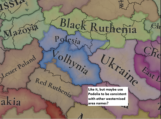
Looks good. As a Ukrainian I like the fact that you use Ukrainian name Podillia :D, but maybe for the consistency if you use westernised names for Volhynia, Polesia, Ruthenia, ..., then maybe it would be better to also use Podolia. Or it can be just my exaggerated perfectionism.
Areas.png


TOPOGRAPHY
I'm really looking forward to the professional review by @Sulphurologist :D, but I have a feeling that you somehow ignored some hills in Galicia and Podolia and even some mountains:
Topography.png


VEGETATION
Here I see some potential for better changes. I think you put too much forests in Polodia and too little forests around Kyiv and Chernihiv.
In Ukraine, according to every our geography schoolbook, we have three main natural zones – steppe, forested steppe and forests (apart from the mountains). They can be even seen in the modern satellite images:
Vegetation zones.pngForest satellite clear.pngForest satellite.png
Even now it can be seen that areas to the north of Kyiv and Chernihiv are quite forested. No way in 1337 there were any huge areas of grasslands up there, it was even more densely forested (farmlands around Kyiv are OK, maybe around other bigger towns too).
At the same time there should be far less forests in the forested steppe areas, I assume mostly a mix of woods, grasslands and just a bit of farmlands and forests. By the way, this is how forested steppe looks like in my region:
Lisostep.png
Dense forests were stretching deeper to the south along the main rivers - the Dnipro, Buh, Dnister. The forest near Chyhyryn and Cherkasy is still alive and it was very important historically for cossacs, by the way.
Here I attach the image from Kaplan et al. (2009). This is some kind of simulation, something between 1000 and 1500 could be used:
Vegeation Kaplan 2009.png
So my rough proposal for Ukrinian vegetation map looks like this:
Vegetation instr.pngVegetation proposal.png

CULTURES
I love it so much, great work!

The only thing is that there should be Halychian culture in the Pokuttya in the South, and to my mind Halychian and Ruthenian cultures should be expanded a bit to the south, at least to Bukovyna and mixed with Moldavian/Romanian/Wallachian.
And maybe a bit more mixed borders between them.
Cultures.png


RAW MATERIALS
Love all the changes, much more diverse now!
  • As for the Ukrainian historical cossack Left bank locations around Lubny, Poltava, Sumy, Hlukhiv - it was a huge saltpeter production region since the early XVI century, mostly ruled by cossack colonels and nobles. They exported a lot of it to Muscovy. Actually as far as I understand, the Cossacks dug the remnants of Kyivan border settlements and fortifications destroyed by the Mongols as well as ancient burial mounds in the steppe, so the saltpeter production was far more efficient than represented by the saltpeter works building in the game. It can be really considered as RGO and represented by at least 1-2 saltpeter RGO locations.
  • Also, the territories of modern-day northern Ukraine (especially Chernihiv, Sumy oblasts) were a known centre for fiber crops production since the Kyivan Rus times till now. So please add a couple of fiber crops RGO locations there instead of wheat too.
I think these changes are very relevant and would make this 'wheat-only' region more diverse :D
Unfortunately, both sources are in Ukrainian only:
Raw goods.png


And thank you for adding the Duchy of Chernihiv, Volhynia and other minors as separate tags.
The only note is maybe instead of Halychia use The Duchy of Halych.

POPULATION
I think, that the town/city criteria shoul be not absolute, but relative within a certain region, so I would add a couple of towns in the region.
Here there is a link with approximate population numbers around 1300-1350::
CityTown.png


So I would add at least Lviv (already had Magdeburg rights, by far the biggest city of Ruthenia), Lutsk, Chernihiv and Sanok (got Magdeburg rights in 1339) as towns as local regional leaders.
Maybe also Ostroh or Belz if the game balance would require it, otherwise not.
TownMap.png


And once again, I am amazed by your dedication and work, thanks!
 
Last edited:
  • 13
  • 10Like
  • 4Love
Reactions:
  • 2
  • 1Like
  • 1
Reactions:
Some NECESSARY changes:
1. Łódź has to be renamed to either Brzeziny (seat of a powiat) or Inowłódz (seat of castellan). Łódź was not even a town before 1426 an even after that it was very small and insignificant before 19th century,
2. Busko (just Busko or Busk, "Zdrój" is a 19th century addition) was a town since 13th century, but not very significant one, belonging to monastic order. Much more important town in that location was Szydłów, with important royal castle, know even today as "Polish Carcassonne",
3. Kowal should be renamed to Brześć. Kowal was a town in Brześć Voivodeship, not other way around. Brześć was also original hereditary sear of former King of Poland - Władysław Łokietek. https://en.wikipedia.org/wiki/Duchy_of_Brześć_Kujawski

Not necessary, but worth adding - Łęczyca and Sieradz should belong to Greater Poland culture group, since it was part of Greater Poland province and therefore used Greater Polish law and customs https://en.wikipedia.org/wiki/Greater_Poland_Province,_Crown_of_the_Kingdom_of_Poland
Also:
4. Kielce should be renamed to Chęciny, since it was Kielce which belonged to Checiny Powiat, not other way around. And there was also important royal castle in Chęciny, whereas Kielce belonged to the Church.
 
Last edited:
  • 5
  • 1
Reactions:
I noticed that lakes in Prussia were added: Śniardwy and Wigry - the largest lakes in modern Poland.
It's a pity that many locations were removed from Prussia - new ones were added but old ones were removed. They had to be kept and new ones added. I miss Johannisburg (the modern Pisz) very much, which is a beautiful old city - I know because it is close to me.
 
Well my only problem is existence of Latvians at start date.
As Latvian we are tought that modern Latvian culture (and also language) is mix of Livonian and Lettgalian and Curonian cultures, so it is bit wierd to see Latgalian region (whit strongest distinct identity in modern day Latvia, and dialect that they claim can be considered their own language) is labeled as modern Latvian, even tho it didnt exist yet.

If its posible i would suggest small change of Latvian culture to Latgalian one.

Cause the cultural regions of Latvia corispond to difrent ancient tribes and their cultures that influenced regions (Curonian for Kurlan, Livonians for Vidzeme ect) so its wierd to see the distinct Latgalian region labeled as modern day Latvian culture. (i know giving each province its own culture is too much to ask XD, but i would suggest at least renaming modern Latvian culture that hasnt unified yet and exist at that time to Latgalian at least)

Otherwise i love the maps and how much research has gone to often forgotten Baltic region
I'm Latvian, too and I strongly disagree. Latvians = Latgalians, they are historically synonyms. Modern Latgalians only split off from Latvians in modern times. Ancient Latgalians are Latvians, other Baltic nations/languages assimilated into them. You would be correct for CK3 timeline, but in 1337 the assimilation of Selonians (almost complete by the start date), Semigallians (already represented as Latvians) and Curonians is already in proccess, it's better to call them as Latvians.

Historically speaking, before the Crusader conquest, Curonians (and also Semigallians and Selonians to a lesser extent, they were closer to Lithuanians than Latvians) had nothing to do with Latvians, they were Western Baltic, closer to Prussians, they only assimilated into them, because they ended up under the Crusader yoke. Not to mention, they were seafarers, while Latvians were landlocked. Also, modern Latvian historical regions show a completely different picture than it was in reality, half of Curonia, Semigallia and Selonia ended up under Lithuania and assimilated into them, they from historical point of view until the Crusder conquest were not Latvians and had their own cultures and languages. So having Latgalian and Latvian cultures is only a modern thing and the split happened after Latvians (Latgalians) had assimilated other Baltic nations and sometime after the dissolution of the Livonian Order. The core of Latvian culture is Vidzeme and Latgalia, while the other nations were assimilated into them. Modern people of Semigallia and Curonia have long forgotten their roots, but they have never been Latvians historically.

Baltic tribes 1200 AD 01.png
 
Last edited:
  • 3Like
  • 1Love
Reactions:
@Kotyk-durkotyk Good suggestion, but those saltpeter-manufactories could actually be represented by the Saltpeter Guild building:
Saltpeter as a raw tradegood on the map is from natural deposits of the stuff.
Yes, could be, I forgot about that building.
But in that land it was also kind of “natural” production too, because they excavated the remnants of old Kyivan-Rus border settlements, fortifications, destroyed by the Mongols, so the production was so efficient and export was quite significant for that period. So actually it was kind of RGO. It may be represented in at least 1-2 locations, not dozens, of course :)
 
Last edited:
  • 1
  • 1
Reactions:
Amazing changes so far, current setup looks very promising. If any further changes will be made:
-the starting war is very weird, Poland was not an ally of Lithuania whatsoever at this point, there was no polish-teuton war here and like a year after game start Bohemian King went with teutons aganist lithuanians with no war aganist Poland
-Poland still should claim to rule 3 of silesian duchies at 1337, King Casimir relinquished his claims to Silesia in 1335 but the pact didn't include Jawor, Nysa, Świdnica and Ziębice duchies which weren't vassals of Bohemia at the time, Nysa location bishopric-duchy should still be independent from Bohemia here and historically up until 1342, Ziębice is rightly a vassal so even though the pact didn't include it, it was vassalised in 1337 anyway
-for population tweaks : after purging a big chunk of prussian baltic population teutonic order invited mostly germans to colonize but in masuria they settled a lot of poles i would add there a sizable maybe 30% masovian minority in 3 southmost locations: Lyck, Niedenburg, Ortelsburg. Polish-Lithuanian culture border should have far less sudovians, they were never part of Masovia in other way than as raiders. There should be none of them in Rawa, maybe some in Grand Duchy. Simmilarly, none of old prussian tribes should be present in Chełmno, at this point mostly Germans and then Poles.
-In Halych and Volhynia quite a lot of burghers and city population was Polish, maybe done just like germans showed on map in poland - only in 2 city locations and mostly burgher class, Jerzy/Yuri
currently ruling there gave them privileges which angered orthodox boyars
-Is it set how to include 1378 second vysehrad congress? As an event?
-A bit too much wool Masovia and Greater Poland, livestock would be much better here but very glad clay and fiber crops were added.
-Prussia historical area should not include Eastern Pomerania (anything west of vistula). Maybe Split Pommern into West and East as 2 areas? Prussia area is way to big comparable to Polish and Ruthenian areas anyway
 
  • 5
  • 4
  • 2Like
Reactions:
3. We considered some feedback (the divide between Poland and Silesian was a bit artificial if no other regional cultures were considered), and also the design in other neighboring regions. They all would be part of the Polish culture group, though.

Does it mean we won't get West Slavic as a culture group?
 
The region looks amazing, and it's a good indicator of the quality of work we'll see after the feedback of other regions is processed. I still see some bits of very good feedback, though, which I hope gets looked at. Some comments I saw in the thread which piqued my interest and which I checked after I saw them being mentioned:
  • More Fiber Crops in Silesia;
  • Wschowa should be transfered from Poland to Głogów, Casimir III only took it in 1343;
  • Kozli (Silesia) independent, Siewierz in PU, Zagan (tag) without Zary (Zary seems to be slightly misplaced, too, and inside Zagan);
  • Maybe Osvětim could be split to include Zátor which was its own duchy from 1445;
  • Opava could be split to include Bruntál, as Bruntál later became separated from Opava;
  • A check of some of Estonia's locations: Wolde should be removed in favour of Sonneburg. Maybe no St. Martens parish, nor a Saarahof manor location, either. Wendau is quite anachronistic and placed in the wrong location, too. Keinis should be renamed to either Grossenhof or Kertel;
  • Kielce should probably be renamed to Checiny? Or both included;
  • Dobrzyn-land should probably be given to the Duchy of Inowroclaw;
  • Lodz should be renamed to Brzeziny or Inowlodz. Busko to Szydlow, Kowal to Brzesc;
  • Kunów should be renamed to Opatów;
  • Chrzanów maybe renamed to Olkusz;
  • Włocławek should be renamed to Brześć Kujawski (the capital there);
  • Maybe the addition of the Duchy of Gniewkowo;
  • Chernihiv region: Oster instead of Starogorodskaya, Lubech instead of Ripky, Nizhyn instead of Unenezh. And optional: Hirsk instead of Horodnia.
There's probably more I missed, and some things might not be valid enough, but keep it coming guys!
 
Last edited:
  • 6Like
  • 2
Reactions: