Hello everyone, and welcome to one more developer diary for map lovers! This is the second this week, after the review of Poland, Ruthenia, and the Baltic. Hurray!
Today we will be taking a look at the lands of Arabia! So let’s start, without further ado:
Countries:

 This week, we have two country maps: one without colored wastelands for clarity, and one with them under the spoiler button. You might also wonder why there isn’t a third one with the Societies of Pops for the region. Well, that’s because Project Caesar has several layers to portray the simulation of a believable world (if you remember, one of our design pillars). A couple of weeks we presented the Societies of Pops as a new type of country, but if you go back to Tinto Talks #4, the Government Overview, Johan mentioned the different types of governments, which now you know are for Settled Countries. One of them is Tribal, which we think makes for a good representation of the most complex and organized tribal societies, which have some estate-like features while keeping some other tribal features.
Therefore, the way we’ve decided that fits better to portray the simulation of the Arabian Peninsula is having a divide between those countries that are Monarchies (Mecca, Yemen, Oman, Ormus, and the Jarwanids), and those that are Tribal (the rest of them). An interesting feature of the latter is that their lands will be full of Tribesmen pops, making the Tribal estate the most important one to manage. As a final note, I’d like you to understand that this is our interpretation for the simulation of the game, although it might not be the only one (as it happened with the discussions about which European countries should be decentralized with several subjects, and which shouldn’t). The good news regarding this is that we will be open to feedback and making changes, as usual; but also, that this setup can easily be changed through the script of the game, thus making it completely moddable after the game is released; so there could potentially be mods making inner Arabia covered by Societies of Pops instead of Tribal Settled countries, if you don’t like/agree with our interpretation, or just prefer it to be different.
Dynasties:

Among the dynasties of the region, you might find some old acquaintances, such as the Rasulids of Yemen or the Nabhani of Oman, while also having a bunch of new ones. And not a week without a bug, of course: the ‘al-Al’ prefix is an error, as those dynasties are using a locative, which is mixed with a second one, from the location; we will have that fixed, then.
Locations:


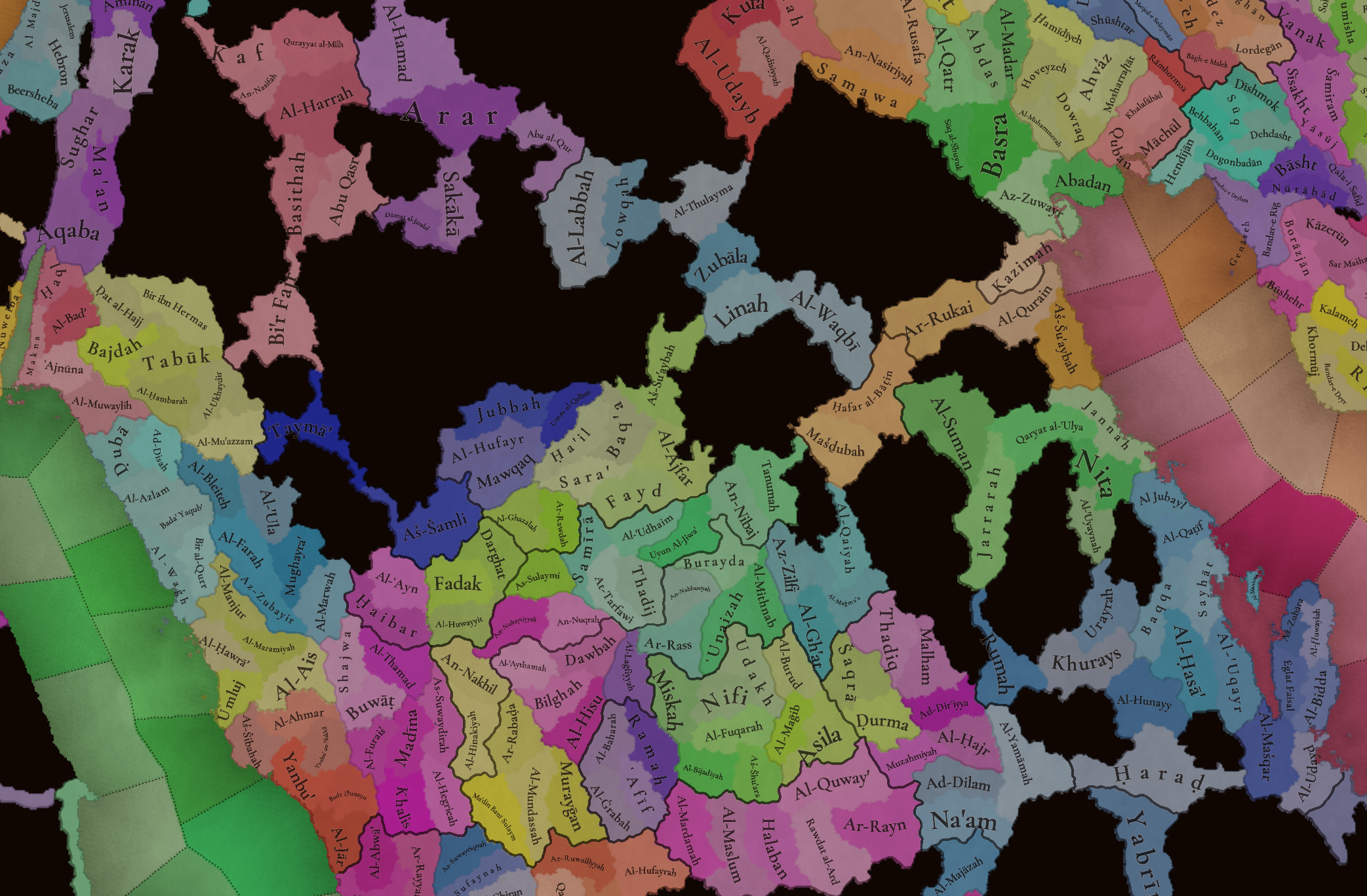
 The locations of the region, with more detailed maps under the spoiler button for three different sections (Northern and Central Arabia, Southern Arabia, and Eastern Arabia).
Provinces:

Areas:

Terrain:


You might notice that most of Arabia is an arid, desertic plateau. The only exception to this is some fertile mountain valleys in Yemen, which was known as Eudaimon Arabia/Arabia Felix for a reason.
Natural Harbors:

Cultures:

The cultural division of the region is quite interesting, as it’s divided into several Arabic-speaking people. And for those that might wonder, yes, Socotra has its own culture, Soqotri. We still have to add some minorities here and there, though, so we will take the opportunity to do it during the map review.
Religions:

The religious division of Arabia is also interesting, having Sunni, Shiite, and Ibady majorities spread across the peninsula. We have yet to address the minorities, which were not ready for the Tinto Maps, so we will show what that looks like on the map, and review as well. By the way, we might do some work in the coming weeks regarding Islam, and one of the things that I think we may tweak is the coloring, as Ibadi is too similar to Shiite; so I think that this might be a good opportunity to ask for your preferences about the coloring of the different branches of the Islamic faith.
Raw Materials:

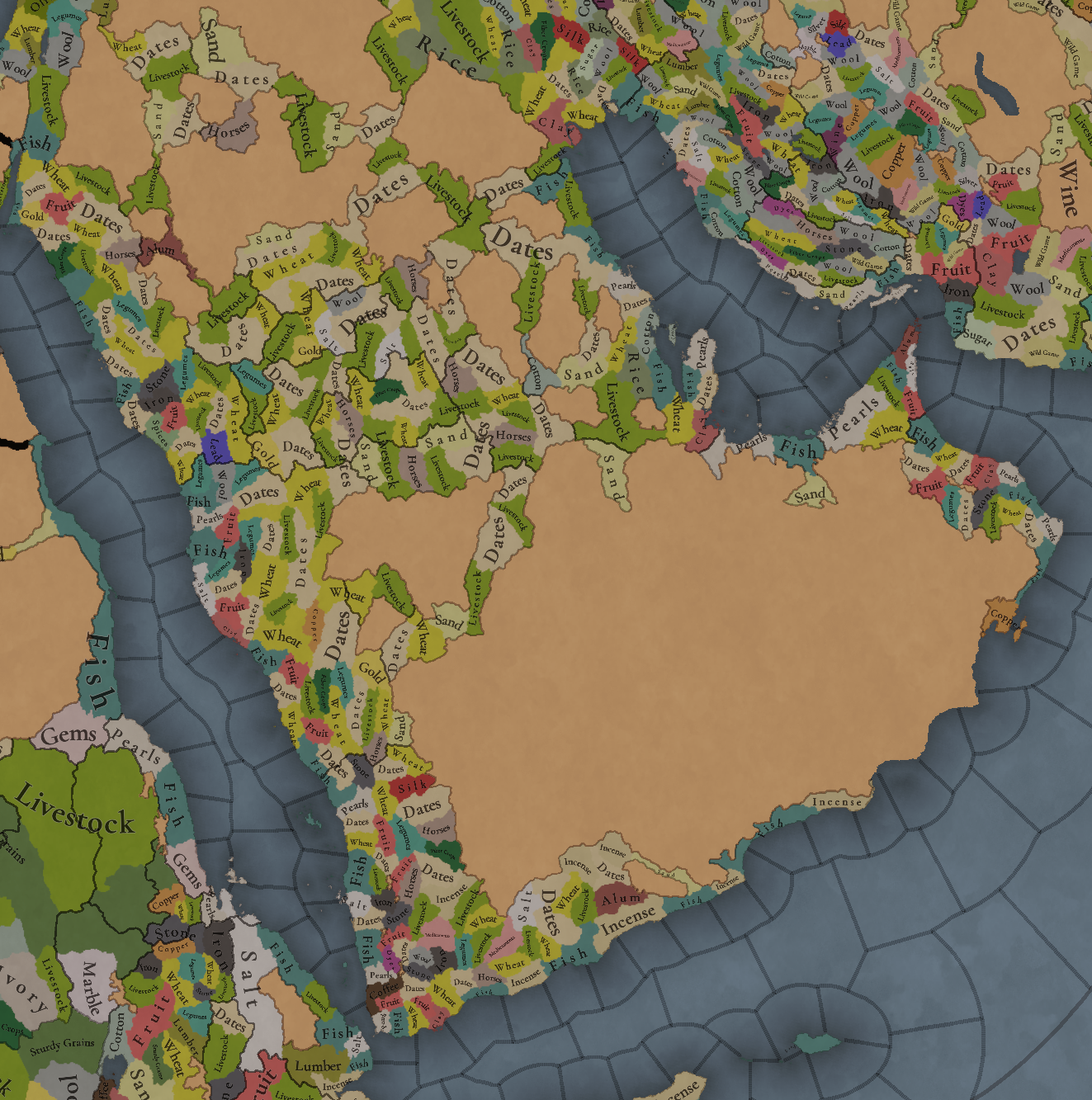
Dates, livestock, horses, and some wheat and sand make for a healthy economy if you’re a Tribal country, I guess? Jokes aside, the desertic lands of Northern and Central Arabia have a more simple resource distribution, while Yemen and Oman, on the other hand, have quite rich resources, such as Pearls, Alum, Copper, Dyes, Silk, and Coffee (who doesn’t like a good mocha?).
Markets:

There are five market centers present in this region: Mecca, Al-Hajar, Al-Hasa’, Hormoz, and ‘Adan. Coupled with the resources in the previous section, the control over ‘Adan and Hormoz will be strategically relevant, as it was historically.
Population:


 This week there aren’t (almost) issues with the population of the region, so we’re able to show it to you. The entire region has around 4.5M pops, which are unevenly distributed; Yemen has 1.6M, and Mecca 776K, making for more than half of the total, while a good chunk of it belongs to the Mamluks (that control all the area around Madina.
And that’s all for this week! For the next one, I have good news: we have finished the feedback review of Anatolia, and therefore I’ll post it on Monday! That way it will make for a week without a Tinto Talks more bearable. And on Friday, there will be maps for a new region, Iran and the Caucasus! See you!
Today we will be taking a look at the lands of Arabia! So let’s start, without further ado:
Countries:


Therefore, the way we’ve decided that fits better to portray the simulation of the Arabian Peninsula is having a divide between those countries that are Monarchies (Mecca, Yemen, Oman, Ormus, and the Jarwanids), and those that are Tribal (the rest of them). An interesting feature of the latter is that their lands will be full of Tribesmen pops, making the Tribal estate the most important one to manage. As a final note, I’d like you to understand that this is our interpretation for the simulation of the game, although it might not be the only one (as it happened with the discussions about which European countries should be decentralized with several subjects, and which shouldn’t). The good news regarding this is that we will be open to feedback and making changes, as usual; but also, that this setup can easily be changed through the script of the game, thus making it completely moddable after the game is released; so there could potentially be mods making inner Arabia covered by Societies of Pops instead of Tribal Settled countries, if you don’t like/agree with our interpretation, or just prefer it to be different.
Dynasties:

Among the dynasties of the region, you might find some old acquaintances, such as the Rasulids of Yemen or the Nabhani of Oman, while also having a bunch of new ones. And not a week without a bug, of course: the ‘al-Al’ prefix is an error, as those dynasties are using a locative, which is mixed with a second one, from the location; we will have that fixed, then.
Locations:


Provinces:

Areas:

Terrain:


You might notice that most of Arabia is an arid, desertic plateau. The only exception to this is some fertile mountain valleys in Yemen, which was known as Eudaimon Arabia/Arabia Felix for a reason.
Natural Harbors:

Cultures:

The cultural division of the region is quite interesting, as it’s divided into several Arabic-speaking people. And for those that might wonder, yes, Socotra has its own culture, Soqotri. We still have to add some minorities here and there, though, so we will take the opportunity to do it during the map review.
Religions:

The religious division of Arabia is also interesting, having Sunni, Shiite, and Ibady majorities spread across the peninsula. We have yet to address the minorities, which were not ready for the Tinto Maps, so we will show what that looks like on the map, and review as well. By the way, we might do some work in the coming weeks regarding Islam, and one of the things that I think we may tweak is the coloring, as Ibadi is too similar to Shiite; so I think that this might be a good opportunity to ask for your preferences about the coloring of the different branches of the Islamic faith.
Raw Materials:

Dates, livestock, horses, and some wheat and sand make for a healthy economy if you’re a Tribal country, I guess? Jokes aside, the desertic lands of Northern and Central Arabia have a more simple resource distribution, while Yemen and Oman, on the other hand, have quite rich resources, such as Pearls, Alum, Copper, Dyes, Silk, and Coffee (who doesn’t like a good mocha?).
Markets:

There are five market centers present in this region: Mecca, Al-Hajar, Al-Hasa’, Hormoz, and ‘Adan. Coupled with the resources in the previous section, the control over ‘Adan and Hormoz will be strategically relevant, as it was historically.
Population:


And that’s all for this week! For the next one, I have good news: we have finished the feedback review of Anatolia, and therefore I’ll post it on Monday! That way it will make for a week without a Tinto Talks more bearable. And on Friday, there will be maps for a new region, Iran and the Caucasus! See you!


.jpg)