• We have updated our Community Code of Conduct. Please read through the new rules for the forum that are an integral part of Paradox Interactive’s User Agreement.

Tinto Maps #9 - 5th of July 2024 - Carpathia and the Balkans

Greetings, and welcome to another Tinto Maps! This week we will be taking a look at Carpathia and the Balkans! It will most likely be an interesting region to take a look at, with a lot of passion involved… So I’ll just make an initial friendly reminder to keep a civil discussion, as in the latest Tinto Maps, as that’s the easiest way for us to read and gather your feedback, and improve the region in a future iteration. And now, let’s start with the maps!

Countries:
Countries.png

Carpathia and the Balkans start in a very interesting situation. The Kingdom of Hungary probably stands as the most powerful country in 1337, but that only happened after the recovery of the royal power enforced by Charles I Robert of the House of Anjou, who reined in the powerful Hungarian nobility. To the south, the power that is on the rise is the Kingdom of Serbia, ruled by Stefan Uroš IV Dušan, who has set his eyes on his neighbors to expand his power. The Byzantine Empire, meanwhile, is in a difficult position, as internal struggles ended in Andronikos III being crowned sole emperor, at the cost of dividing the realm; both Serbia and Bulgaria have in the past pressed over the bordering lands, while the Ottomans have very recently conquered Nicomedia. The control over the Southern Balkans is also very fractioned, with a branch of the Anjou ruling over Albania, the Despotate of Epirus under the nominal rule of Byzantium as a vassal, Athens, Neopatria and Salona as vassals of the Aragonese Kings of Sicily, Anjou protectorates over Achaia and Naxos, and only nominal Byzantine control over Southern Morea. It’s also noticeable the presence of the Republics of Venice and Genoa, which control several outposts over the Adriatic and Aegean Seas. A final note: in previous maps, Moldavia was shown in the map, but we’ve removed it from it, and it will most likely spawn through a chain of events in the 1340s.

Dynasties:
Dynasties.png

The House of Anjou rules over Naples, Hungary, Albania, Achaia, and Cephalonia; they’re truly invested in their push for supremacy over the region. Apart from that, each country is ruled by different dynasties, except for Athens and Neopatria, ruled by the House of Aragón-Barcelona.

Locations:
Locations 1.png

Locations 2.png

Locations 3.png

Locations 4.png
This week we’re posting the general map of the region, along with some more detailed maps, that can be seen if you click on the spoiler button. A starting comment is that the location density of Hungary is noticeably not very high; the reason is that it was one of the first European maps that we made, and we based it upon the historical counties. Therefore, I’m already saying in advance that this will be an area that we want to give more density when we do the review of the region; any help regarding that is welcome. Apart from that, you may notice on the more detailed maps that Crete appears in one, while not being present in the previous one; because of the zooming, the island will appear next week along with Cyprus, but I wanted to make an early sneak peek of the locations, given that is possible with this closer zoom level. Apart from that, I’m also saying in advance that we will make an important review of the Aegean Islands, so do not take them as a reference for anything, please.

Provinces:
Provinces.png

Provinces! Nothing outstanding to be commented on here; as usual, we’re open to any feedback regarding them.

Terrain:
Climate.png

Topography.png

Vegetation.png

Terrain! The climate of the region is mostly divided between Continental and Mediterranean, with some warmer and some colder regions. Regarding the topography, the Carpathian mountains are famously important and strategic, while the Balkans are a quite hilly and mountainous region, which is also greatly covered by woods and forests.

Cultures:
Cultures.png

Here comes the fun part of the DD: The cultural division of the Balkans! A few comments:
  1. Hungary is full of different minorities. Transylvania, especially, is an interesting place: there we have a mix of ‘Hungarians’, ‘Transylvanians’ (which are the Romanian-speaking inhabitants of the region), ‘Transylvanian Germans’, and ‘Szekely’ people.
  2. We have divided the Southern Slavic-speaking region into their dialectal families of Slovene, Croatian, Bosnian, and Serbian.
  3. The Southern Balkans are mostly divided among Bulgarian, Albanian, and Greek cultures.
  4. We’re also portraying plenty of other cultures, such as Dalmatians, Aromanians, Sclavenes, Arvanites, Cumans, Jasz, or Ashkenazi and Romanyoti Jews.

Religions:
Religion.png

This one is also interesting. Apart from the divide between Western Catholicism and Eastern Orthodoxy, we have the Krstjani in Bosnia, Bogomils (the pink stripes both in Bosnia and Macedonia), and Paulicians in Thrace. The Jewish populations do not pass the threshold percentage to appear on the map, but there are plenty of communities across the region.

Raw Materials:
Raw Materials.png

The materials of the region. Something very noticeable is the richness of minerals, with plenty of Iron, Copper, Tin, Lead, Gold, and Silver. Specifically, Slovakia is very rich, and you definitely want more settlers to migrate to the region, and exploit its resources. The region is also very rich in agricultural resources, as you can see.

Markets:
Markets.png

The region is mostly divided among four markets: Venice, Pest, Ragusa and Constantinople.

Country and Location population:
Population 1.png

Population 2.png

Population 3.png

Population 4.png
Country and location population (which I’ve also sub-divided, and is under the Spoiler button).

And that’s all of today! I hope that you find the region interesting; we certainly think that it is. Next week we will go further south, and we will take a look at the Syrian Levant and Egypt. Cheers!
 
  • 193Like
  • 69Love
  • 7
  • 4
  • 3
  • 1Haha
Reactions:
Feedback for this is taking a while..... especially since we already got a sneak peek at what looked like a completed version
Maybe they decided to go back to the drawing board for one reason or another. Since I wish for the region(s) to have the best possible, most accurate depiction, I don't mind waiting for another month or even more. I'm sure many of us feel this way.

Also, I claimed the post for the current year:p
 
  • 5
  • 1Haha
Reactions:
Why not use this French maps instead? from 1200-1359, thus including 1337.
map1.jpg

intemeierea-moldovei.jpg


According to this french encyclopedia:
Thus, according to this French encyclopedia:

- In 1247 , the Diploma of the Knights of St. John describes a Wallachian voivode east of the Carpathians , tributary to the Tatar Khan of the Golden Horde. (So we have 1 Vlach ruler mentioned, but not named, in 1247, in Moldavia)
- The Moldavians of northern Moldavia (knesate of Onut , near Hotin) came into conflict with their Ruthenian overlords in the neighboring principality of Galicia. (So we also have Onut and Hotin as "the Moldavians" described here)
- Meanwhile, those of southern Moldavia, on the other hand ( knesate of Bârlad ) remained faithful to their alliances with the Galicians and Hungarians , who helped them defend themselves against Tatar raids. (So 1 more Vlach ruler in the south of Moldavia at Barlad)

These are before Dragos and Bogdan.

- In the 13th century Moldavia was a federation of " cnesates " ( vassal duchies of Galicia and / or Hungary ) : Onutu - Hotin , Străşineţ , Baia , Neamţu , Soroca and its troglodyte monasteries , Hansca , Aski ( today Iaşi or Jassy , which takes its name from Iasses ) and Bârlad.

But the Moldavians united against Dragoş and preferred Bogdan of Dolha , also a voivode from Maramureş but opposed to Hungarian suzerainty . After several years of guerrilla warfare , in 1359 , Bogdan was recognized by the Moldavians as prince in place of Dragoş 's descendants , who had to return to Maramureş . The city of Baia became the capital of the federation in 1359 under the scepter of Bogdan , now called Bogdan I the Founder ( Bogdan Întemeietorul ) . This federation of cnesates then became a Voivodate governed by Voivodes , while the former cnesates became counties ( ţinuturi ) , governed by the great boyar families.

Notice it says the Moldavians.

Mystery solved I guess.

Sources:
  1. Nick . Serban Tanaşoca , Romanian Heraldry , Anuarul Inst . HAS . D. Xenopol , Iasi , 1997
  2. Bugaï , Nikolaï F. : Deportation in Ukraine , Belorus in Moldova // Lageria , принудительный труд и депортация , Германия , Эссен , 1999 : The Deportation of the peoples of Ukraine, Belarus and Moldova . Camps , forced labour and deportation . Ed .: Dittmar Dahlmann and Gerhard Hirschfeld . - Essen 1999 , pp .: 567-581
  3. Alain Ruzé : Moldova , L' Harmattan , Paris , 1997 , ISBN 2-7384-6018-6
  4. The map gallery is a synthesis of the " Westermann Grosser Atlas zur Weltgeschichte ", 1985 , ISBN 3 - 14 - 100919 - 8 , of the " DTV Atlas zur Weltgeschichte " , 1987 translated by Perrin , ISBN 2 - 7242 - 3596 - 7 , of the “ Putzger historischer Weltatlas Cornelsen " 1990 , ISBN 3-464-00176-8, from the " Atlas of the Peoples of Central Europe " by André and Jean Sellier at La Découverte , 1992 , ISBN 2-7071-2032-4 , with detailstaken in the Történelmi atlasz of the Hungarian Academy , 1991 , ISBN 963-351422-3 CM and in the historico - geographic Atlas of the Romanian Academy ,1995, ISBN 973-27-0500-0 .
Great Source! But isn't it just Wikipedia in French?
1731926300791.png


The sources you mention from this place are not connected to the text you copied:

Source 1. is here
1731926453544.png

Source 2. in 1859 in USSR about Ukrainian population
1731926570876.png

Source 3. is about political parties
1731926659230.png

Source4. are all the maps itself
1731926695660.png


The text you copied is unsupported tho. Please when you provide sources, at least use the ones that prove your point, and not one about USSR or political parties.

But I do find the depictions of cnesates highly interesting. It shows the more precise political situation rather than everything being controlled by the Golden Horde

However this does not prove the Romanian majority, but it does prove to me there were more Romanian speakers I have presumed. Look at the duchies in the north, they by all means must contain a major Slavic population.
 
Last edited:
  • 3Like
  • 2
Reactions:
Maybe they decided to go back to the drawing board for one reason or another. Since I wish for the region(s) to have the best possible, most accurate depiction, I don't mind waiting for another month or even more. I'm sure many of us feel this way.

Also, I claimed the post for the current year:p
Maybe the dev chat is currently going through a thousands of messages long extremely heated argument thread about the exact ethnic makeup of some random province in Bosnia that will get several developers reported to HR, and then sent over the "do research on Papua languages in New Guinea" team for punishment (it's actually a relief after the Balkans)
 
  • 9Haha
Reactions:
Maybe the dev chat is currently going through a thousands of messages long extremely heated argument thread about the exact ethnic makeup of some random province in Bosnia that will get several developers reported to HR, and then sent over the "do research on Papua languages in New Guinea" team for punishment (it's actually a relief after the Balkans)
"Get me a latin professor, and find out what Vavan means."

Edit: A paradox staff member just marked my "Remove the Balkans from the game" as helpful. My aunty was right. Screw all of your petty debates, they are removing the balkans.

Love you paradox.
 
Last edited:
  • 4Like
Reactions:
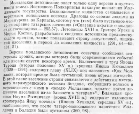
If this is fair but speculative explain it to me how it was possible:

But I seriously doubt a Voivevode like Dragos and Bogdan had enough Romanian population in Maramures to populate an area the size of Moldavia even if empty, let alone if it had other ethnicities to become a majority.
And still remained the majority in Maramures (so not all of them) as the Voivodship of Maramures kept existing and being ruled by Dragos' descendents up until the early 15th century.

So, I went deeper into this subject, and I found the Original source - what have I shown before was not and I apologise.
It is a detailed paper that was written by Lazar Polevoy (L. L. Polevoĭ)

The method he used was categorising names used in Slavic-Romanian sources by three groups.
Bear in mind this is my bad translation of the methodology:
1. Starting form, when the name of the village is not solidified at all. example: "village, where Negesh lives" or "village, where the house of Pitik is"
2. Changing form, where villages are using the name with the addition of the founder
3. Full form, where we have only the name of the village

then based on the cases where dates are described he formulated a pattern of date estimation of village founding. Example:
1731930209326.png

Here is an example of calculated dates of founding the villages.

He is the accumulation of the research on the cities showing how many villages were founded at every timestep (Growth rate of number of villages)
1731930230541.png

He also mentioned that the bigger cities were founded by the consolidation of the population around them in the start of the XIV century.

Next, he talks about the presumed population of the land

Maybe there wasn't a migration since they already migrated there since 800-900? We only have the migration of a Kneaz and Voivod which you yourself said it's fair that it's not enough to populate the country.
SO about migration he also has notes.
1731930985861.png

Here are the mentions of the colonisation of southern lands by the Golden Horde, by forcing settlers.

1731931154381.png

here are the mentions of empty lands from the Moldavian chronicle.
The author also supports this with "сказание в кратце о молдавских государях" and as I understand Chronica Hungarorum (please fact check me Hungarian speakers) contains works of Küküllei János where we have a separate volume XLIX titled: chapter How did Moldavia, which was previously depopulated, receive new inhabitants. I can not read that but I did find it
Szintén az ő uralkodása idején Bogdán, a máramarosi valahok vajdája ama vidék hozzácsatlakozó valahjaival titokban átköltözött a magyar korona alá tartozó Moldva földjére, melyet a tatárok szomszédsága miatt lakosai régen elhagytak. Bár a király serege gyakran harcolt ott, a valahok nagyon elszaporodván elterjeszkedtek abban az országban. Az ottani valahok által választott vajdák a magyar király hűbéreseinek vallják magukat, s hűbéradó fizetésére kötelesek, a szokott adófizetés mellett.
Does it say the lands were abandoned a long time ago because of Tatars? (Translation has been done by Makkasag in the next post)

Also it includes Naum Râmniceanu chronicle also includes phrases claiming Moldavia was sparse (can't find it)

Here he includes many sources to say that all propose that disorganised migration (not connected with the political stuff of Bogdan) did happen from the mountains and happened right before the Moldavian kingdom's creation
1731934592646.png

sources like
1731934749926.png

and others

Here, he notes that the biggest population density in the XIV century was around rivers Tazlau, Trotuș, Bistrița, Nemțișor and limited by Siret, Moldova and Suceava River., Bukovina and Codru are also highly populated. The only additions are Chilia and Bilhorod/Cetatea Albă
1731933925440.png


He also states here that
1731933987341.png

The repelment of Tatars created a better environment for the colonisation of lands, away from the Carpathians.

lands in question are Barlad plato, rivers Vaslui, Tutova and rivers I do not know. And with an increase of population in Moldova after XIV those areas became more leveled with the previously mentioned highly populated

The villages in this area are much more sparse and highly condensed instead of being spread out, which can indicate a recent settlement of groups of people

here is the population estimates of the entire duchy in the middle of the XIV century
1731934075561.png


measuring the entire population to be 78 thousand people

And again we have our map where he drew his research on
1731934119252.png


here are the locations of all the cities he looked into with the population density map in the corner.
1731934206521.png


As a side fact which will influence how the paper is perceived autor mentioned Karl Marx in the Introduction
1731934328107.png

Which is highly laughable but is a thing a lot of research of Soviet times does.

He also writes not Romanian but specifically Moldovian.
 
Last edited:
  • 6Like
  • 1Love
Reactions:
please fact check me Hungarian speakers
I downloaded Chronica Hungarorum. Only 140 megabytes.

Does it say the lands were abandoned a long time ago because of Tatars?
"In his time, the Voivode of Máramaros, Bogdán, gathered around himself the vlachs of the land, and secretly returned to Moldavia belonging under the hungarian crown, which because of the neighbouring tatars was long uninhabited.

And although the king attacked them commonly, the numbers of the vlachs living in the territory grew big, grew into a country.

And the voivodes, who are elected by the country's vlachs, call themselves the king's vassals, are obligated to serve, and obligated to pay the regular tax."
 
  • 3
Reactions:
BTW. In my searches, I have found a Golden Horde city ruins called Şehr al-Djedid

1731935438572.jpeg


Romanian Wiki states:
Ca urmare a bătăliei de la Apele Albastre (1362), Hoarda fără rezerve și-a slăbit influența în regiunea pruto-nistreană, însă nu într-o măsură atât de mare încât să piardă controlul nemjlocit asupra sud-estului Moldovei. Se pare că în ultimii ani orașul era condus de un principe autonom, fapt confirmat și prin baterile de monede cu inscripția Amrallah (adică amir, emir, duce), fapt nemaiîntâlnit în restul imperiului, până atunci[5].


As a result of the Battle of Blue Waters (1362), the Unreserved Horde weakened its influence in the Pruto-Dniester region, but not to such a great extent that it lost immediate control over southeastern Moldavia. It seems that in recent years the city was ruled by an autonomous prince, a fact confirmed by the batteries of coins with the inscription Amrallah (meaning amir, emir, duke), a fact unprecedented in the rest of the empire until then.

And English
Old Orhei contains traces of different civilizations, including the remnants of earthen and wooden fortresses of GetoDacian fortress (6th–1st centuries B.C.), the Golden Horde fort Shehr al-Jedid (or Yangi-Shehr) (14th century), a Moldavian fort dating from the 14th-16th centuries, an Orthodox monastery (c. 14th century), and the Moldavian town of Orhei from the 14th–16th centuries.

mentions this: Tyragetia. Muzeul Național de Istorie a Moldovei p. 84

Unfortunately, I can't find this paper

Here is the tourist guide to this place as I understand
The first sentence of the next paragraph emphasizes the continuity
of the fortifications and the urban settlements “after the Mongols had
abandoned the Prut-Dniestrian region in 1369 […]”. Throughout the
remaining pages of the guide, more information on the details of the
Şehr al-Djedid settlement is offered, however with a strong focus on the
description of the architectural heritage. The page with the title “The
Orheiul Vechi Citadel, second half of the 14th – mid 16th centuries”
offers a first paragraph with regard to the Tatar-Mongol settlement:

The stone citadel […] represents the central fortification of Orheiul
Vechi. It was built at the end of the 1360s (14th century) as a military-
political and administrative residence of the Mongol governor. The
construction of typical oriental style possesses a trapeze-shaped form
with maximum dimensions of 127.0x92.0 m. Those 4 circular towers,
disposed at the corners, built into a special decorative style, together
with those 5 fortifications situated at the mid of the sides, served as a
contra-fort for the citadel’s walls.
Ibid.
The following page is about “The Palace of Pircalab, second half of
the 14th – mid of 16th century”:
In the central part of the citadel, near the northern wall, are the ruins
of a monumental palace […], today under the ground, which once
knew a stormy history. In the first half of the 14th century on this
place was built a Muslim mausoleum that included also a crypt. Later
(1366) the construction was transformed into the Palace of the regio-
nal governor; […]
Ibid.
And the theme of buildings is taken up on a page dedicated to “The
Mosque and the Caravanserai, 14th century”:
The monumental complex composed of Mosque […] and Caravanserai
[…] belongs to the period of the Golden Horde. The first complex
represented a religious Muslim construction and the second one ser-
ved as storage of goods. […] In the centre of the northern side is the
entrance into the mosque, which in the 14th c. was arranged under
the form of a monumental portal. In the north-eastern corner of the
building are the ruins of a minaret from which were held the Muslim
calls to prayer. The Islamic cult construction from Orheiul Vechi is
shown on a lapidary Arabic inscription recovered at this site: “This
mosque was BuilT By oRDeR of The Pious BenefacToR alih…san”. The
rectangle-shaped caravanserai with the dimensions of 56.0 x 27.0 m
has two entrances on the northern and southern sides, and, in the past,
it had portals with typical oriental arabesques.
(Bold letters in the original text, Ibid.)
A last page provides information on “The Tartar Bath, 14th century”:
In the 14th c. in the town on the Raut functioned three baths […]. The
most important construction of this type is the bath at the ford, […].
The toponym „feredeu”, applied by the natives to this place, conserves
the living memory about this medieval bath. The bath was made of
stone. The construction was rectangular with maximum dimensions
of 37.0 x 21.0 m. The bath’s noticeable foundation represented a typi-
cal oriental structure evolved from ancient Roman thermae. […]
Ibid.
The omission of a comprehensive contextualisation of the narratives
of history in tourist media is a frequent issue in tourist historiography
(Posch, 2012). With the representations of the Tatar-Mongol Golden
Horde empire on Moldovan territory, it is obvious that this omission
relates to both the background of its existence as well as its wider impli-
cations of a nomadic world in the North-Pontic steppe region.
 
Last edited:
SO about migration he also has notes.
1731930985861.png

Here are the mentions of the colonisation of southern lands by the Golden Horde, by forcing settlers.
Useful clarification: this says that the Golden Horde colonization of Southeastern "Dniester-Carpathia" was short-lived and didn't last past the 1360s.
(looks like 1362 for the Romanian displacement of Tatars in the region was spot on...)

lands in question are Barlad plato, rivers Vaslui, Tutova and rivers I do not know.
Birlad and Bahlui rivers are mentioned. The last one I can't find.
 
  • 2
Reactions:
Why not use this French maps instead? from 1200-1359, thus including 1337.
map1.jpg

intemeierea-moldovei.jpg


According to this french encyclopedia:
Thus, according to this French encyclopedia:

- In 1247 , the Diploma of the Knights of St. John describes a Wallachian voivode east of the Carpathians , tributary to the Tatar Khan of the Golden Horde. (So we have 1 Vlach ruler mentioned, but not named, in 1247, in Moldavia)
- The Moldavians of northern Moldavia (knesate of Onut , near Hotin) came into conflict with their Ruthenian overlords in the neighboring principality of Galicia. (So we also have Onut and Hotin as "the Moldavians" described here)
- Meanwhile, those of southern Moldavia, on the other hand ( knesate of Bârlad ) remained faithful to their alliances with the Galicians and Hungarians , who helped them defend themselves against Tatar raids. (So 1 more Vlach ruler in the south of Moldavia at Barlad)

These are before Dragos and Bogdan.

- In the 13th century Moldavia was a federation of " cnesates " ( vassal duchies of Galicia and / or Hungary ) : Onutu - Hotin , Străşineţ , Baia , Neamţu , Soroca and its troglodyte monasteries , Hansca , Aski ( today Iaşi or Jassy , which takes its name from Iasses ) and Bârlad.

But the Moldavians united against Dragoş and preferred Bogdan of Dolha , also a voivode from Maramureş but opposed to Hungarian suzerainty . After several years of guerrilla warfare , in 1359 , Bogdan was recognized by the Moldavians as prince in place of Dragoş 's descendants , who had to return to Maramureş . The city of Baia became the capital of the federation in 1359 under the scepter of Bogdan , now called Bogdan I the Founder ( Bogdan Întemeietorul ) . This federation of cnesates then became a Voivodate governed by Voivodes , while the former cnesates became counties ( ţinuturi ) , governed by the great boyar families.

Notice it says the Moldavians.

Mystery solved I guess.
BTW the first map also showcases Jasz and Csangos populations as independent entities, not controlled by any Moldavian duchies

1731943567989.png
 
Last edited:
@Pavía idk if I'll ever get an answer on this thread, but are there Jewish pops anywhere else in the balkans except for Hungary and Byzantium(which were confirmed)?
Very likely but obviously jewish pops arent gonna be visible without going into the statistics page due to being a true minority. While the feedback threat is currently all about arguing about majority and major minoritys since those are the only things we can give feedback about.
 
  • 1Like
Reactions:
Definitely wouldn't say that. The narrative is not as tight as in season one, but certainly wouldn't say "fell off" and would even argue about "too many plot holes"; what holes, exactly?
1. The hole in vi’s heart after caitlyn breaks up with her. The relationship is WAY TOO RUSHED by all standards and measurements. Only reason it feels natural is cuz the whole league community has been shipping them for the past 10 years pr so.

2. The hole missing from Jinx’s head in act I. Caitlyn had the shot several times on her mother’s killer and didn’t take it.

3. All of a sudden both caitlyn and vi care about innocent children caught in the crossfire. But killing chemtank users (Some were children) or unleashing the grey in civilian areas mo biggie.

I could go on
 
  • 3Like
Reactions:
1. The hole in vi’s heart after caitlyn breaks up with her. The relationship is WAY TOO RUSHED by all standards and measurements. Only reason it feels natural is cuz the whole league community has been shipping them for the past 10 years pr so.

2. The hole missing from Jinx’s head in act I. Caitlyn had the shot several times on her mother’s killer and didn’t take it.

3. All of a sudden both caitlyn and vi care about innocent children caught in the crossfire. But killing chemtank users (Some were children) or unleashing the grey in civilian areas mo biggie.

I could go on
CaitVi has been pretty obviously built up since the middle of season 1, so I'm not sure how you're concluding it's been rushed. What I would say is that the way it's treated in season 2 doesn't really feel entirely logical. Like in season 1 Vi is the person who tells Jayce he's a crybaby for killing a child soldier. But in season 2 the only way they could think of to create drama between Caitlyn and Vi is by having Vi freak out because Caitlyn MIGHT accidentally shoot a child accomplice of their mortal enemy. And then 2 episodes later Cait completely goes back on everything she was involved in since the breakup because she meets Vi again.
 
If Zeprion persists until the end of the year, we can expect 200 pages.
It takes 2 for tango, or in this case 5. But sure, everyone else can post but I can't.
BTW the first map also showcases Jasz and Csangos populations as independent entities, not controlled by any Moldavian duchies
View attachment 1218140
But it also shows Moldavian duchies in places you said there are Slavs and Tatars.

As for the source itself.
I don't think it's just Wikipedia in French. As French Wikipedia has nothing.

Moreover mentions more Romanians than you said there were:

- "In 1247, the Diploma of the Knights of St. John describes a Wallachian voivode east of the Carpathians , tributary to the Tatar Khan of the Golden Horde."
(This can only mean a Moldovan duchy, before Dragos and Bogdan, since you said the migrations of Dragos and Bogdan is what must have brought the Romanians here)

- . "In 1277 , while the voivodes Litovoi and Bărbat were fighting for their autonomy , the Moldavians of northern Moldavia ( knesate of Onut , near Hotin ) came into conflict with their Ruthenian overlords in the neighboring principality of Galicia."
(knesate of Onut is described as "the Moldavians of northern Moldavia" thus not slavic as you said in northern Moldavia, so again other Romanians before Dragos & Bogdan)

- "Those of southern Moldavia , on the other hand ( knesate of Bârlad ) remained faithful to their alliances with the Galicians and Hungarians , who helped them defend themselves against Tatar raids."
(knesate of Bârlad is once again described as Moldavian, rather than Tatar, which is again other Romanians before Dragos & Bogdan)

- "The retreat of the Tatars from the Golden Horde created more favourable conditions for a process of unification of the cnesates . In the early years of the 14th century , German chronicles mention a country of the Wallachians (Wlachenlant) led by a voivode in the north of Moldavia."
(It could be the knesate of Onut or some other knesate, but once again describes a "Wallachian" aka Romanian/Vlach voivode in the north of Moldavia before Dragos and Bogdan)

- "In the 13th century Moldavia was a federation of " cnesates " ( vassal duchies of Galicia and / or Hungary ) : Onutu - Hotin , Străşineţ , Baia , Neamţu , Soroca and its troglodyte monasteries , Hansca , Aski ( today Iaşi or Jassy , which takes its name from Iasses ) and Bârlad . Hungary was also present in the future Moldavia with the Csangos settlers , near the Siret River , and posted garrisons on the path of the Tatar invasions : this is the origin of toponyms such as Miclăuşeni ( Miklósfalu ) , Orhei ( Varhély ) , Chişinău ( kis - jenő : the small spring ) or Ciobruci ( Russified form of Ciubărciu , from csupór , the churn ) . The trade route along the Siret , which connected northern Europe to the mouths of the Danube , played an important role in the economic and political development of these territories . The cities Moldavian lands developed , including Baia ( civitas Moldaviae ) , mentioned in the 14th century as a fief of Dragoş de Bedeu , a voivode from Maramureş , vassal of the King of Hungary , Louis of Anjou . The latter had organized this fief in the basin of the Moldova River , following an expedition in 1343-1345 to the east of the Carpathians , with a view to strengthening Hungarian influence against the Tatars and the Galicians."
(here it essentially lists them all, therefore the map)
AtlHistMold3.jpg

By contrast, there appears to be no canesats and voivodats mentioned as slavic.

- "The city of Baia became the capital of the federation in 1359 under the scepter of Bogdan , now called Bogdan I the Founder ( Bogdan Întemeietorul ) . This federation of cnesates then became a Voivodate governed by Voivodes , while the former cnesates became counties ( ţinuturi ) , governed by the great boyar families."
(Suggesting that the unification of Moldavia was more of a union than a military conquest, which could hardly be possible has the vast majority of other canesats and voivodats not been Romanian & it also explains how such a relatively small population from Maramures could populate all of Moldavia within 10 years, even with a small population, it didn't)

- "All these small duchies had taken up the colors ( gold and sinople with six bands ) of the "Regnum Valachorum" ( 1186-1261 , founded by the Deleanu , Caloian and Asan dynasties in present - day southern Romania , Bulgaria and Macedonia ) of which they considered themselves the heirs [ 1 ] ."
(these Duchies, from before Dragos and Bogdan, considered themselves heirs of the Vlach part from the Second Bulgarian Empire, this further means they couldn't have been from Maramures, as Maramures was not part of the Second Bulgarian Empire, but Wallachia was)


- "Alexander I the Good ( Alexandru cel Bun ) received from Wallachia ( under the name of Bessarabia after the founding dynasty of Wallachia : that of the Basarabs ) the country of Vrancea south of Trotuş and five ports at the mouths of the Danube and the Black Sea : Galaţi , Reni , Obluciţa , Chilia and Cetatea Albă." (This is the same that that Wikipedia text without a source said)
Vlachs/Romanians from Moldova - can not find proof of this

Vlachs/Romanians from Moldova - can not find proof of this
The formation of the Romanian people has become a controversial subject due to political reasons and interests: some modern historians from Austria and Hungary reject the continuity of the Daco-Romans after the withdrawal of the Roman Empire south of the Danube and insist on the formation of the people south of the Danube; Bulgarian historians reject the theory of formation south of the Danube, considering that the formation of the Romanian people took place only north of the Danube; some Russian historians accept the continuity, but only in Transylvania and Banat, denying continuity and Latin origins in Moldova.
Source: Vlad Georgescu, The Romanians : a history. Ohio State University Press,Columbus, 1991, p.12

In the 10th century, the Pechenegs invade and destroy the fortified settlements at Echimăuți (settlement), Alcedar, and Calfa, near the Dniester, inhabited by Romanians and Slavs.
Source: Gheorghe Postică, Civilizația medievală timpurie din spațiul pruto-nistrean (secolele V-XIII), Chișinău, 2006, p. 64

On a commemorative stone from the 11th century in the village of Sjonhem on the island of Gotland, it is mentioned that the Varangian Rodfos, probably a Viking leader, was killed by "blakumen during his travels abroad" (blakumen is the term used by the Varangians for the Vlachs/Romanians). The event most likely took place to the east of the Carpathians, along the route along the Dniester from the Varangians to the Greeks.
Source: Curta, Florin (2006). Southeastern Europe in the Middle Ages, 500-1250. Cambridge University Press.p.303. ISBN 978-0-521-89452-4.

In 1040, Casimir, Duke of Poland, formed an alliance with Yaroslav the Wise, Duke of Kiev, and received 1,000 foot soldiers to help him recapture the territories he had lost in Poland. On this occasion, an army is mentioned that consisted of Ruthenians, Prussians, Dacians, and Getae (possibly Romanians).
Source: Vincentius Kadlubko, Scriptores Historiae Polonae, Bibliothecae Heilsbergensis, pag.14

In 1068, the Vlachs/Romanians from Moldova and the Pechenegs led by Osul participated in a raid campaign in Transylvania and Hungary, which ended with the Battle of Chiraleș in Transylvania, where they were defeated. These details are found in a Russian chronicle.
Source 1: Русскій хронографъ, 2, Хронографъ Западно-Русской редакціи,in PSRL, XXII, 2, Petrograd, 1914, p.241
Source 2: V. Spinei, The Romanians and the Turkic Nomads North of the Danube Delta from the Tenth to Mid-Thirteen Century, Brill, 2009, p.118

In 1070, the Vlachs/Romanians from Moldova were involved, along with the Pechenegs and the Ruthenians, in an expedition led by King Boleslaus of Kraków. The campaign is commented on by the Polish chronicler Długosz. The alliance between the Romanians, Pechenegs, and Ruthenians is plausible.
Source: I. Dlugosz, Historiae Polonicae, vol.I, Lipsca,1711,col.265

The appearance of the Cumans among the Romanians took place around 1070-1075, as recorded in several chronicles, following numerous battles fought by the Cumans against the Pechenegs, Kievan Russians, Romanians (ulak), and Hungarians. These battles are mentioned in the oldest Turkic chronicle, the Oguzname.
Source: Curta, F. Southeastern Europe in the Middle Ages, 500-1250 , Cambridge Medieval Textbooks, 2002, p.306

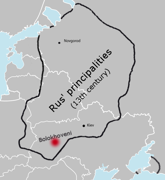
And I found a source on the Bolokhovians = Romanians.
Lisseanu wrote about the city of Bolechov, the most important center of the Bolohovians, that it was referred to in a Polish chronicle as "Vila Valachorum dicta" (the village called of the Vlachs).
Source: G.Popa Lisseanu, Continuitatea românilor în Dacia.Editura Vestalia, Bucurest, 2014, p.75

I also found that there is no consensus on the location of the Bolokhovians:
Bolohoveni_land_from_A.V._Boldur_description.PNG
Bolokhoveni.png

Left - according to Alexandru V. Boldur Right - according to Martin Dimnik.

So there may havee never been Bolokhovians in Moldavia at all.

In the 11th-13th centuries, Moldova was located in the area of influence of the Cumans (and later the Tatars), and religiously, it was under the influence of the principalities of Galicia and Volhynia. In Moldova, small local Romanian principalities emerged, such as the one at Onut (near Hotin), the one at the fortress of Hansca (in the Lăpușnei region), the one at Strășineț, and others. The religious center of the Onut principality was located there.
Source: Nicolae Iorga, Momente istorice, Cultura națională, București, 1927

The religious center of the Onut principality seems to have been in the locality of Vasileu or Vasilău (Vasîliv in Ukrainian), located 10 km west of Onut, on the southern bank of the Dniester. There, ruins of a church with a stone foundation and a cemetery full of stone crosses were discovered, some of which date back to the 12th century.
Source: Victor Spinei, Spațiul Nord-Estic Carpatic în mileniul întunecat, Editura Universității A. I. Cuza, Iași, 1997, p. 155.

The borders of the Moldovans were along the Dniester River. The southern border of Halicz passed through the Dniester, encompassing cities and fortresses such as Vasileu (the village of Vasîliv, Zastavna County) - Onut - Bacota - Ușița - Cucelmin - Calius. The Iași people (an Iranian-related group, similar to the modern Ossetians from the Caucasus) ruled a small territory with a center at "Aski Torg," a location mentioned in chronicles as Civitas iassiorum (today's Iași). The Dniester Valley and Bugeac were, at that time, controlled by the Tatars.
Source: Gheorghe Postica, Civilizația medievală timpurie din spațiul pruto-nistrean (secolele V-XIII), București, Ed. Academiei Române, 2007, p.241

The consequences of the great Mongol invasion were depopulation and famine for Moldova and the other invaded territories. For the Cumans, it marked their disappearance from history. After their withdrawal in 1243, the Tatars continued to dominate and impose tribute on the Galicians, Bolohovians, Romanian principalities, and Bulgarians. The dependence of some Romanian territories on the Hungarian Kingdom was removed and replaced by a dependence on the Tatars.
Source: Alexandru Gonța, Românii și Hoarda de Aur, Editura Demiurg, Iași, 2010, p.86

In 1277, Thomas Tuscus' Chronicle mentions the participation of the Moldovans in the battle between Ottokar, the ruler of Bohemia, and the Prussians: "Burtenos et infideles sibi in adjutorium vocat, sed Deo disponente Brutenis ac Blacis inter se discordantibus suo rex Boemiae proposito defraudatur" ("He calls upon the Burtenos and his infidels for assistance, but by God's will, with the Brutenis and Blacs in discord among themselves, the King of Bohemia is thwarted in his goal"). These details, according to Al I. Gonța, indicate that there was a Moldavian principality under Mongol domination at the time. Brutenis was already an established name for a population near the Prut River.
Source: Alexandru Gonța, Românii și Hoarda de Aur, Editura Demiurg, Iași, 2010, p.100

In 1285, Khan Nogai, based at Isaccea near the Danube, launched a new invasion of Transylvania and Hungary. Historian Alexandru I. Gonța described in detail the passage of the Tatars through Moldovan territory, accompanied by Romanians and Cumans from the subjected territories. One Tatar and Romanian column entered the Buzău Valley and reached the Land of Bârsa, while another column advanced along the Siret Valley through the Prisăcani-Tulgheș Pass and devastated the Bistrița region, inhabited by Romanians and Saxons. The columns reached Pest (today's Budapest) in Hungary but failed to capture the important fortresses. A plague that spread among the horses and transport animals forced the Tatars to retreat. King Ladislaus the Cuman pursued the retreating Tatars with an army mainly composed of Catholic Romanians but also of Orthodox Romanians from Transylvania (this episode is covered in Moldovan chronicles in the stories about Roman and Vlahata).
Source: Alexandru Gonța, Românii și Hoarda de Aur, Editura Demiurg, Iași, 2010, p.104
They say about modern Bukovina, in that time a lot of stuff happened. So it is not a proof at all
Based on what you got to the conclusion that Britannica and Wikipedia speaks of modern Bukovina? This clearly does not speak about modern Bukovina.

part1.png

part2.png
 
  • 1
  • 1
Reactions: