• We have updated our Community Code of Conduct. Please read through the new rules for the forum that are an integral part of Paradox Interactive’s User Agreement.

Tinto Maps #30 - 20th of December 2024 - South America

Hello and welcome to one Friday of map-loving! Today is special, as our 30th Tinto Maps, devoted to South America, is the last regular one. This implies that it won’t be the last, though - we plan to have two Tinto Maps Extra on December 27th and January 3rd, and then we will continue with the Tinto Maps Feedback posts as we progress with the map review.

But don’t worry, as on the first post-Christmas Friday, January 10th, I will start a new series, Tinto Flavor, in which we will show the content that we have been working on for Project Caesar. And I promise you, it’s a ton of content, so you will have to play the game in due time to discover it all…

Before we continue, one note: as we're covering a lot of lands today, don't be shy and ask for more detailed maps of the type you want wherever you want them, and I'll try to provide in the replies. And now, let’s start with the South American maps:

Countries
Countries1.png

Countries2.png

Countries3.png

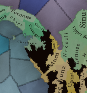
Most of the countries that can be considered being at a State-wise level in 1337 are mostly concentrated in what is today Perú. We have famous ones, as the Chimu or Chincha, and you may also see a tiny country, Qusqu, which would later become the Inca Empire, the long-term goal while playing in the region.

Dynasties
Dynasties1.png

Dynasties2.png


SoPs
Sops1.png

Sops2.png

Sops3.png

Sops4.png

Sops5.png

There are SoPs spread out all across the continent, making for a really interesting mix in the Peruvian area (again). We're already thinking about how to better visualize the coexistence of these two types of countries in the political layer, but it's going to take us some more time to get there.

Locations
Locations1.png

Locations2.png

Locations3.png

Locations4.png

Locations5.png

One note: I'll talk a bit more in-depth about the design of the Brazilian locations if you scroll down, in the Terrain section.

Provinces
Provinces1.png

Provinces2.png

Provinces3.png


Areas
Areas1.png

Areas2.png


Terrain
Climate.png

Topography.png

Vegetation.png

There are huge geographical variations in South America, being one of the most diverse continents. One of the things I wanted to discuss is that we've tried to portray the Mata Atlântica, the original forest cover that was present in Brazil before the Portuguese colonized it, and a different type of land exploitation started. In this regard, we've been reading the feedback of the Brazilian community, and I want to say that our intention here is to portray the most realistic situation for 1337. That said, we've already internally discussed that we may reduce its scope, so it doesn't look so extreme, but we'd like to hear your opinions about it. And here you have one of the images that we used as a reference for it, so you get a good grasp of our intention:
Mata Atlantica.png

Development
Development.png


Natural Harbors
Harbors1.png

Harbors2.png


Culture
Cultures1.png

Cultures2.png

Cultures3.png

Cultures4.png

Cultures5.png

Cultures6.png

The jewel of the crown in this region. We've tried to portray the Pre-Columbian cultural diversity of these lands as accurately as possible, and, well, here you have the results.

Languages
Languages1.png

Languages2.png

Languages3.png

And the languages that group these cultures.

Religions
Religions1.png

Religions2.png

Religions3.png

We've tried to do our best to group the cultural religions of South America into different groups, based on common believes, gods, rituals, etc. Let us know what do you think of them. Oh, also, the Inti religion has its own differentiate mechanics, which we'll explain in the future!

Raw Goods
Raw Materials1.png

Raw Materials2.png

Raw Materials3.png

Raw Materials4.png

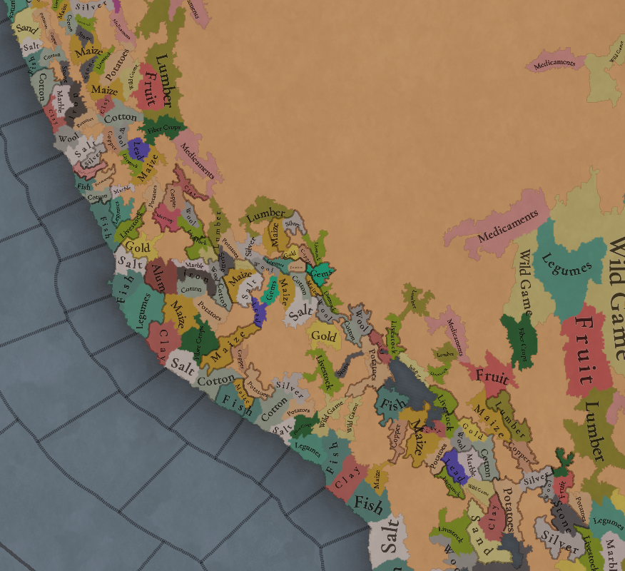
Lots of different natural resources in South America. You may note that some are more common compared to other regions (such as Medicaments). We've also been tweaking the color of different resources, with the help of your feedback!

Markets
Markets.png

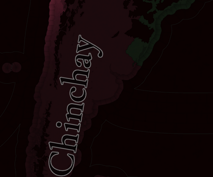
The green market is centered around Teyuna, and the red one is Chinchay.

Population
Some issues with the map of the region this week (sadly), so let's discuss the numbers. The total in the continent is 10.22M, divided this way:
  • 1.66M in Colombia
  • 1.2M in Brazil
  • 5.07M in Andes
  • 877K in Chaco
  • 1.4M in La Plata
And that's all for today! We hope that you enjoyed the Tinto Maps series! We've definitely done, and it's also greatly helping us to make Project Caesar a much better game, with your help and feedback. Cheers!
 
  • 137Like
  • 57Love
  • 32
  • 9
  • 6
Reactions:
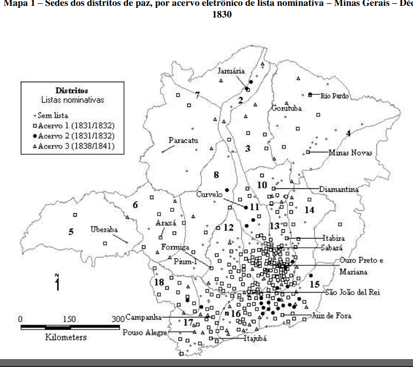
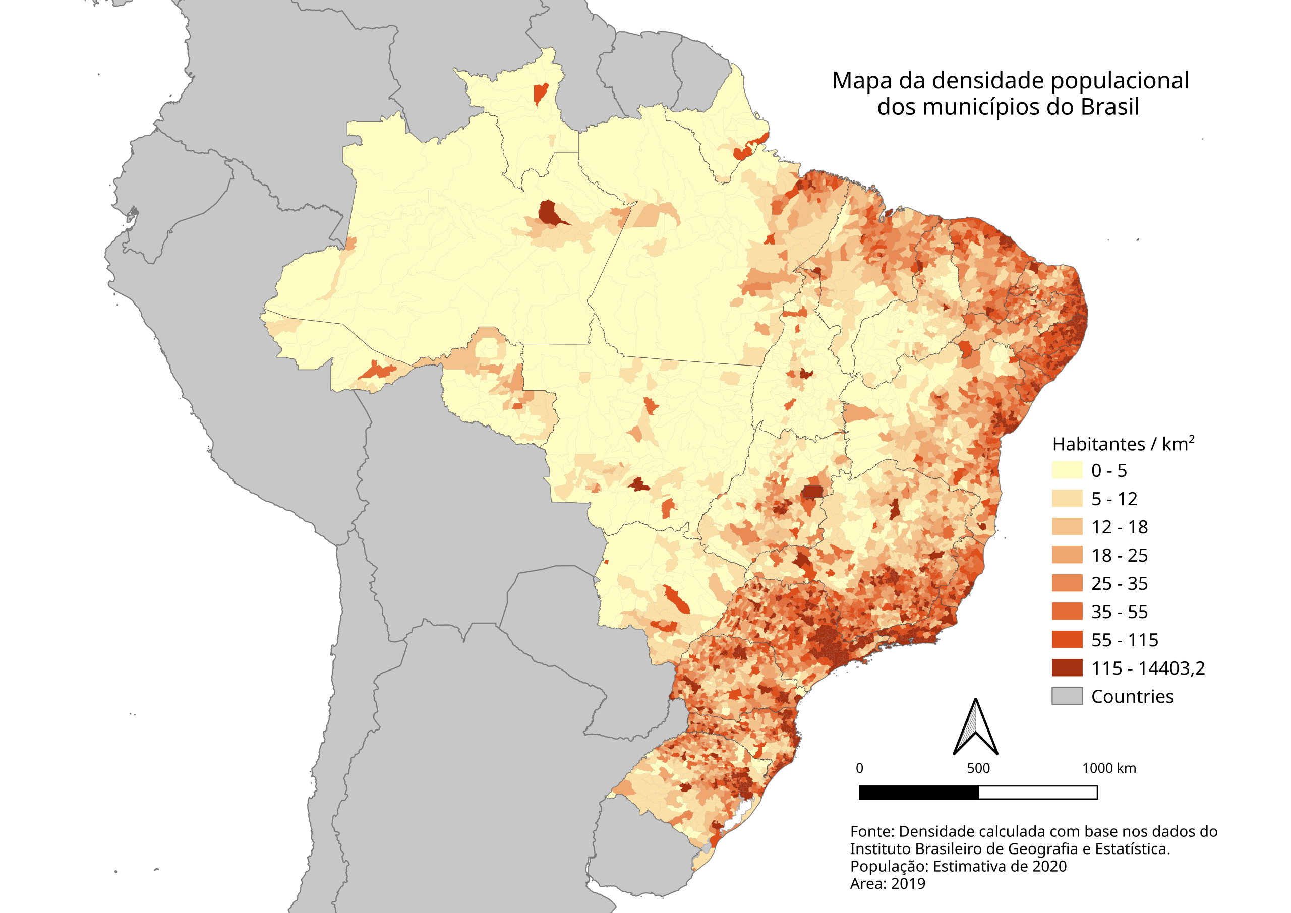
All these wastelands in brasil don't make sense, populated areas of brazil are in these wastelands, Minas Gerais, São Paulo and Parana, Minas Gerais was the most populated brazilian state in 18th century and 19th century, because of the gold rush
Captura de tela 2024-12-20 122102.png


Brazil population density
Population_density_Brazil_2020.svg.png
 
  • 19Like
  • 6
  • 2
  • 1Haha
  • 1
Reactions:
All these wastelands in brasil don't make sense, populated areas of brazil are in these wastelands, Minas Gerais, São Paulo and Parana, Minas Gerais was the most populated brazilian state in 18th century and 19th century, because of the gold rush View attachment 1233723

Brazil population density
View attachment 1233722
Great maps for our feedback review, thanks!
 
  • 52Like
  • 3
  • 1Haha
Reactions:
Alright so there is quite a few points I am really disappointed by:

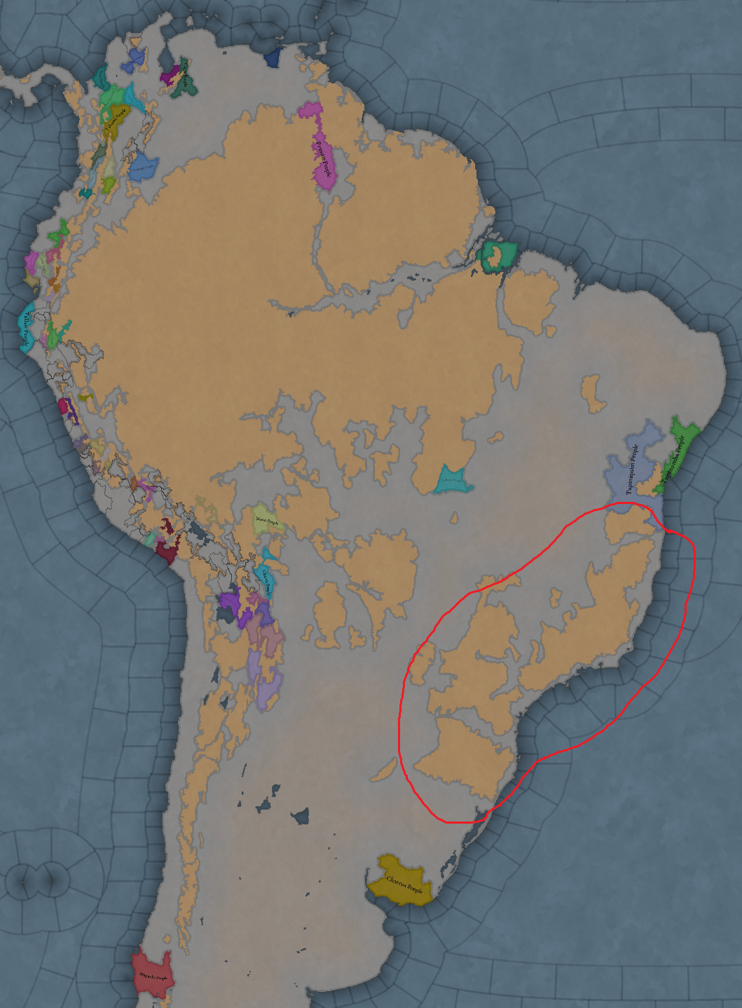
(1) The wasteland seteup in Brazil, which has been already mentioned in the comments.
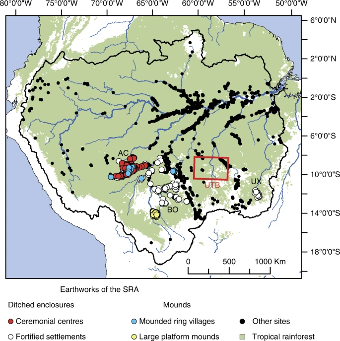
(2) Just yesterday I was watching this documentary about a rich network of settlements in the Amazon:

1734706692850.png
(https://www.nature.com/articles/s41467-018-03510-7)

The Amazonian basin was by no means a pristine wilderness, but rather a carefully-maintained garden

(3) Disappointed by the map being just so empty. I mean so much of North America is covered by SoPs and looking at South America it all appears all pretty empty. I mean if not even the Guaranis are playable, than its rather sad.
(4) The languages set up. I would expect the languages to represent not the worlds primary language families, , on the level of Indo-European or Sino-Tibetan, but at least a level beyond that. So to breakup the Tupi-Guarani family into various branches, including "Tupi", "Guarani", "Munduruku" and "Xingu" languages.
(5) For the love of all that is dear to you, why would you put the entirety of Brazil under a market that is inaccessible to all of them? And its center on the Carribean coast of Columbia? Why? If we have evidence of the Marajoara culture, why not give them a specific market? Alright, you may claim that the area is undevelopped and what not... by why, did you stick the entire Andean civilisation under Andean civilisation under one market from Ecuador till Urugay?
Perhaps the area could be subdivided into three, if not more markets...
1734708377519.png
 
  • 20Like
  • 6
  • 2
  • 1Love
Reactions:
for heaven's sake remove that deadzone in there , the colonists literally turned that are to a farmable fully habitable land during the 1600s and there is 2 treads in here describing well how and why that area should be colonisable and not a dead zone .

remind you that north america's west stayed almost entirely a forest till the late 1700s early 1800s yet it doesnt have a single area turned to a deadzone except in the apalachian heights so WHY brazile have those giant parts forbidden ? i cant think of the logic at all

this is exactly why i told you that yemen should be linked to Oman too , because they expand in the 1600s while sweden dont expand north till much later but its sweden who have right to colonise its north but a whole arabic culture and nation located in between those 2 is considered a wasteland just because go figure.


1734708496847.png
 
  • 25
  • 9Like
  • 2
  • 1
Reactions:
I like the current state of the Atlantic Forest. Not sure listening to the Brazilian community alone is a great idea - they seem to prefer chopping down their forest hehe (joke/fact)
Do not assume that the current fires in the Amazon have the approval of the Brazilian masses, because they do not. Furthermore, the Atlantic Forest (where I live, in an enclave in the Forest) is not impassable like the Amazon, where the extensive river network and the heat at the equator are important factors.
 
  • 22
  • 2
Reactions:
Argentina's setup is almost a disappointing as EU4's. o_O

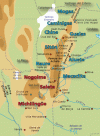
The Andean Foothills of Argentina, the regions that compromise the Argentine NOA and the Cuyo have a rich history of settlement and interaction with the various Andean Cultures, which the north of Argentina at times being included as part of the 'vertical archipelago' notion of the natives of the Titicaca Basin.
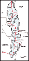
  1. The Calchaquí Valleys of IRL Catamarca, Tucumán, Jujuy and Salta have a complex history of habitation, as evidenced by archeological evidence dating back to 10.000 years of settlement, - this region was irrigated, settled and was the target of Incan mitmaqkuna, given the region's rich nature as a oasis valley.
    Before the Incans arrived, this region was inhabited by Calchaquí or Pazioca Natives who had a complex network of valley city-states and constantly interacted and traded with their Andean counterparts, those down the Andean piedmont in the Argentine Chaco, amongst others.

  2. Jujuy province, which immediately borders IRL Bolivia, had a long culture of mining, settled habitation and pastoralism, as evidenced by their incorporation into the Incan Empire - given that the Jujuy cultures interred their dead in Chullpas, they pretty much shared Andean traditions as part of the 'Vertical Archipelago' notion mentioned above.

  3. San Luis, Mendoza and the southern end of San Juan provinces were part of the Huarpe or Warpe complex - Huarpes were a settled culture who lived in small villages of 50 a 100 persons at a time - they were agrarian, mainly growing corn, quinoa and a selection of cuyoan beans.

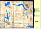
  4. For the Huarpes in and around Mendoza, the Lakes of Guanacache were a massive historical factor - these were a series of lakes which aren't even represented in the current draft, I'm assuming because they dried out by IRL - they were the livelihoods for some of these natives, as they sailed, fished and engaged in water politics with them.

    Seeing Tulare Lake but not Guanacache is genuinely confusing, as there's plenty sources available online which will help you accurately represent it - It's currently represented in the Victoria 2 mod Divergences of Darkness Rework, where I implemented it off of research papers.
All of the above regions should really have settled tags, and at the bare minimum SOP's for the native cultures in Mendoza - the Incans had to fight wars in these regions, they didn't walk into an anarchistic wasteland devoid of societal relations

Moving from the aforementioned regions, IRL Córdoba and Southern San Luis also have a very long history of habitation around these provinces fertile valleys - these'd be the Hênia and the Kamiare, commonly grouped together as the Comechingones - they are well documented and researched, and Comechingon toponymy still persists and is very widespread in Córdoba province.

Comechingones should be SoPs, given that they while they recognised several caciques they were at heart a seminomadic group - they practiced agriculture, but they were moreso known for hunting and pastoralism.

I attached maps for
1. Mendoza's native caciquedoms (everything below Diamante being Puelche nomads )
2 & 3. Cordobese and Sanluisan Comechingon caciquedoms/settlements
4. The Calchaquí Valleys laid over modern Argentine provinces, including important settlements within (note the Quilmes ruins as important)
5. Colonial depiction of the Lakes of Guanacache overlaid on modern day rivers & Mendoza City
 

Attachments

  • mapacuyo (1).png
    mapacuyo (1).png
    48,7 KB · Views: 0
  • mapa.gif
    mapa.gif
    36,4 KB · Views: 0
  • Mapa_con_parcialidades_y_territorios_de_la_etnia_henia_en_la_actual_provincia_de_cordoba (1).jpg
    Mapa_con_parcialidades_y_territorios_de_la_etnia_henia_en_la_actual_provincia_de_cordoba (1).jpg
    370,7 KB · Views: 0
  • Figura-11-Mapa-de-los-Valles-Calchaquies-de-Catamarca-Tucuman-y-Salta-donde-se.png
    Figura-11-Mapa-de-los-Valles-Calchaquies-de-Catamarca-Tucuman-y-Salta-donde-se.png
    194,4 KB · Views: 0
  • fig4apor.jpg
    fig4apor.jpg
    118,8 KB · Views: 0
Last edited:
  • 17Like
  • 11
  • 5
  • 4Love
Reactions:
Nice work!
I must second the petition for a passable connection in the Upper Amazon region, Orellana's and Teixieira's expedition and the struggle between the Omagua(Cambeba), spanish missions and portuguese slavist raiders are evident reasons to add this region.

Also the Gran Chaco region could be put to good use for the Ava(Chiriguano), Chané and Guaykuru SoPs.
 
Last edited:
  • 6Like
  • 2
  • 2
Reactions:
Hello and welcome to one Friday of map-loving! Today is special, as our 30th Tinto Maps, devoted to South America, is the last regular one. This implies that it won’t be the last, though - we plan to have two Tinto Maps Extra on December 27th and January 3rd, and then we will continue with the Tinto Maps Feedback posts as we progress with the map review.

But don’t worry, as on the first post-Christmas Friday, January 10th, I will start a new series, Tinto Flavor, in which we will show the content that we have been working on for Project Caesar. And I promise you, it’s a ton of content, so you will have to play the game in due time to discover it all…

Before we continue, one note: as we're covering a lot of lands today, don't be shy and ask for more detailed maps of the type you want wherever you want them, and I'll try to provide in the replies. And now, let’s start with the South American maps:

Countries
View attachment 1233623
View attachment 1233624
View attachment 1233625
Most of the countries that can be considered being at a State-wise level in 1337 are mostly concentrated in what is today Perú. We have famous ones, as the Chimu or Chincha, and you may also see a tiny country, Qusqu, which would later become the Inca Empire, the long-term goal while playing in the region.

Dynasties
View attachment 1233635
View attachment 1233636

SoPs
View attachment 1233659
View attachment 1233660
View attachment 1233661
View attachment 1233662
View attachment 1233663
There are SoPs spread out all across the continent, making for a really interesting mix in the Peruvian area (again). We're already thinking about how to better visualize the coexistence of these two types of countries in the political layer, but it's going to take us some more time to get there.

Locations
View attachment 1233642
View attachment 1233643
View attachment 1233644
View attachment 1233645
View attachment 1233646
One note: I'll talk a bit more in-depth about the design of the Brazilian locations if you scroll down, in the Terrain section.

Provinces
View attachment 1233649
View attachment 1233650
View attachment 1233651

Areas
View attachment 1233620
View attachment 1233621

Terrain
View attachment 1233622
View attachment 1233664
View attachment 1233665
There are huge geographical variations in South America, being one of the most diverse continents. One of the things I wanted to discuss is that we've tried to portray the Mata Atlântica, the original forest cover that was present in Brazil before the Portuguese colonized it, and a different type of land exploitation started. In this regard, we've been reading the feedback of the Brazilian community, and I want to say that our intention here is to portray the most realistic situation for 1337. That said, we've already internally discussed that we may reduce its scope a bit, so it doesn't look so extreme, but we'd like to hear your opinions about it. And here you have one of the images that we used as a reference for it, so you get a good grasp of our intention:

Development
View attachment 1233634

Natural Harbors
View attachment 1233637
View attachment 1233638

Culture
View attachment 1233626
View attachment 1233627
View attachment 1233628
View attachment 1233629
View attachment 1233630
View attachment 1233632
The jewel of the crown in this region. We've tried to portray the Pre-Columbian cultural diversity of these lands as accurately as possible, and, well, here you have the results.

Languages
View attachment 1233639
View attachment 1233640
View attachment 1233641
And the languages that group these cultures.

Religions
View attachment 1233656
View attachment 1233657
View attachment 1233658
We've tried to do our best to group the cultural religions of South America into different groups, based on common believes, gods, rituals, etc. Let us know what do you think of them. Oh, also, the Inti religion has its own differentiate mechanics, which we'll explain in the future!

Raw Goods
View attachment 1233652
View attachment 1233653
View attachment 1233654
View attachment 1233655
Lots of different natural resources in South America. You may note that some are more common compared to other regions (such as Medicaments). We've also been tweaking the color of different resources, with the help of your feedback!

Markets
View attachment 1233648
The green market is centered around Teyuna, and the red one is Chinchay.

Population
Some issues with the map of the region this week (sadly), so let's discuss the numbers. The total in the continent is 10.22M, divided this way:
  • 1.66M in Colombia
  • 1.2M in Brazil
  • 5.07M in Andes
  • 877K in Chaco
  • 1.4M in La Plata
And that's all for today! We hope that you enjoyed the Tinto Maps series! We've definitely done, and it's also greatly helping us to make Project Caesar a much better game, with your help and feedback. Cheers!
Why can there not be a location without a market assigned?

It is strange to see a gigantic one without any access
1734708746365.png

we can have a threshold that a market can assign a location to itself only if the strength is at least 5.

Also as a solution, there can be "No Market" market
 
Last edited:
  • 2Like
  • 2
Reactions:
You should take away some of the wastelands in the south of brazil, many of the oldest cities, São Paulo among them, where built in those areas marked as wastelands. Also, any chance of portraying the bandeirante expeditions sort of like some regional version of the conquistadores?
 
  • 9Like
  • 7
Reactions:
That would require in-game navigable rivers.

And, to my knowledge, that expedition did not have any bellicose purposes, since it was done during the times of the iberian union.

Would it have succeeded has a wartime expedition? Very hard to say (and then we'd re-enter the whole navigable rivers debate...)
Since the Amazon was primarily navigated on very small ships (canoe size, even the smallest on-map ships like war galleys would be unusually large) and there were no naval engagements up river, the solution is to abstract the situation by making the upper Amazon traversable land terrain. Much like we don't need to micro the many small boats needed for a strait crossing, we should not need to micro an army finding 100 canoes to sail up the amazon. I do not know how much faster than land travel Amazonian sailing is, but since this will be a low importance route the disparity between the strategic speed of a marching army and a hypothetical sailing one won't have a major gameplay impact.

Also, a potential solution: Locations on very large but not ship-navigable inland rivers could have a "canoe network" building that gives friendly land forces a large movement speed boost at the cost of requiring a bunch of wood and manpower to maintain.
 
  • 10
  • 4Like
  • 4
Reactions:
I don't understand why only Mapuche people (central "Reche" or "Reche-Mapuche" would be a more appropriate name) would be considered a SoP in what is now Chile, considering the large amount of complex groups that lived in the meridional Andes during the late intermediate period (also what is often called a "period of regional developments" in argentinian archeology) after the collapse of Tiwanaku influence.
Main groups that could be considered Sops, From North to south (without mentioning the many mobile, pastoralist or hunter-gatherer societies that shared the same space):

Cultura Arica is on its Gentilar phase at this time
Pica-Tarapacá cultural complex
Solor phase
altiplanic tradition groups enter their Toconce-Zapar phase
Copiapo Culture and possibly Animas
Diaguita and possibly Animas
Molle and Diaguita
Aconcagua Cultural Complex
Late intermediate period societies of the Maule
Vergel Cultural Complex
Pitren

edit: regions corresponding to the list of cultures
Arica
Tarapaca
Antofagasta
Atacama
Copiapo and Huasco
Elqui And Limari
Choapa
Central Chile (northern)
Central Chile (southern)
South Central Chile (north of Tolten river)
South Central Chile (south of Tolten river)

edit2: posted a recommended reading list later in the thread
 
Last edited:
  • 12
  • 3Like
  • 1
Reactions: