• We have updated our Community Code of Conduct. Please read through the new rules for the forum that are an integral part of Paradox Interactive’s User Agreement.

Tinto Maps #30 - 20th of December 2024 - South America

Hello and welcome to one Friday of map-loving! Today is special, as our 30th Tinto Maps, devoted to South America, is the last regular one. This implies that it won’t be the last, though - we plan to have two Tinto Maps Extra on December 27th and January 3rd, and then we will continue with the Tinto Maps Feedback posts as we progress with the map review.

But don’t worry, as on the first post-Christmas Friday, January 10th, I will start a new series, Tinto Flavor, in which we will show the content that we have been working on for Project Caesar. And I promise you, it’s a ton of content, so you will have to play the game in due time to discover it all…

Before we continue, one note: as we're covering a lot of lands today, don't be shy and ask for more detailed maps of the type you want wherever you want them, and I'll try to provide in the replies. And now, let’s start with the South American maps:

Countries
Countries1.png

Countries2.png

Countries3.png

Most of the countries that can be considered being at a State-wise level in 1337 are mostly concentrated in what is today Perú. We have famous ones, as the Chimu or Chincha, and you may also see a tiny country, Qusqu, which would later become the Inca Empire, the long-term goal while playing in the region.

Dynasties
Dynasties1.png

Dynasties2.png


SoPs
Sops1.png

Sops2.png

Sops3.png

Sops4.png

Sops5.png

There are SoPs spread out all across the continent, making for a really interesting mix in the Peruvian area (again). We're already thinking about how to better visualize the coexistence of these two types of countries in the political layer, but it's going to take us some more time to get there.

Locations
Locations1.png

Locations2.png

Locations3.png

Locations4.png

Locations5.png

One note: I'll talk a bit more in-depth about the design of the Brazilian locations if you scroll down, in the Terrain section.

Provinces
Provinces1.png

Provinces2.png

Provinces3.png


Areas
Areas1.png

Areas2.png


Terrain
Climate.png

Topography.png

Vegetation.png

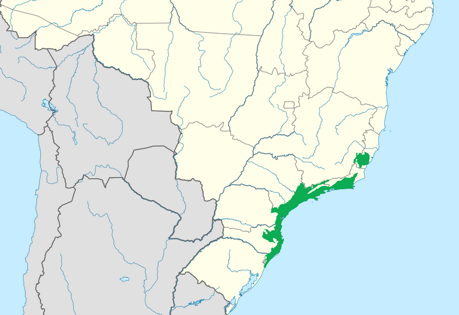
There are huge geographical variations in South America, being one of the most diverse continents. One of the things I wanted to discuss is that we've tried to portray the Mata Atlântica, the original forest cover that was present in Brazil before the Portuguese colonized it, and a different type of land exploitation started. In this regard, we've been reading the feedback of the Brazilian community, and I want to say that our intention here is to portray the most realistic situation for 1337. That said, we've already internally discussed that we may reduce its scope, so it doesn't look so extreme, but we'd like to hear your opinions about it. And here you have one of the images that we used as a reference for it, so you get a good grasp of our intention:
Mata Atlantica.png

Development
Development.png


Natural Harbors
Harbors1.png

Harbors2.png


Culture
Cultures1.png

Cultures2.png

Cultures3.png

Cultures4.png

Cultures5.png

Cultures6.png

The jewel of the crown in this region. We've tried to portray the Pre-Columbian cultural diversity of these lands as accurately as possible, and, well, here you have the results.

Languages
Languages1.png

Languages2.png

Languages3.png

And the languages that group these cultures.

Religions
Religions1.png

Religions2.png

Religions3.png

We've tried to do our best to group the cultural religions of South America into different groups, based on common believes, gods, rituals, etc. Let us know what do you think of them. Oh, also, the Inti religion has its own differentiate mechanics, which we'll explain in the future!

Raw Goods
Raw Materials1.png

Raw Materials2.png

Raw Materials3.png

Raw Materials4.png

Lots of different natural resources in South America. You may note that some are more common compared to other regions (such as Medicaments). We've also been tweaking the color of different resources, with the help of your feedback!

Markets
Markets.png

The green market is centered around Teyuna, and the red one is Chinchay.

Population
Some issues with the map of the region this week (sadly), so let's discuss the numbers. The total in the continent is 10.22M, divided this way:
  • 1.66M in Colombia
  • 1.2M in Brazil
  • 5.07M in Andes
  • 877K in Chaco
  • 1.4M in La Plata
And that's all for today! We hope that you enjoyed the Tinto Maps series! We've definitely done, and it's also greatly helping us to make Project Caesar a much better game, with your help and feedback. Cheers!
 
  • 137Like
  • 57Love
  • 32
  • 9
  • 6
Reactions:
Agree with everything else, but goods produced are dynamic, meaning that more likely than not it would change to gold in the region for colonial countries
And yet gold deposits in other regions, from Alaska to the russian Far East are all already present. Indeed, there was even a dev response about mineral raw goods being represented if they were exploited during the timeframe, so it's still a bit bemusing.
 
  • 7Like
Reactions:
Yeah, that wasteland in southeast Brazil is... weird, to say the least.

Don't get me wrong, both the Serras and Mata Atlântica were hard places to travel, but it was mostly due to sudden change in elevation. The Serras were also, sometimes, referred to as "the green wall" or just "the wall" (as in the Great Wall of China) due to how hard it was to pass through (though that probably is a nickname that came very late in the game's timeframe).
That region was very economically active, especially in early colonization attempts. São Paulo being one of the oldest cities in Brazil and being a gateway to the countryside.
I think that wastelands here would be best represented by having some thinner wastelands running along the sea with a couple passages, possibly with mountain terrain (but i'm not sure on that).

1734710618247.png

(Aproximate extent of the Serra do Mar).

Also, Just four SoP's in Brazil? That's... well, that is going to be a rehash of my 2021 opinion on North America in EU4.
There could (and should, in my opinion) be a few more SoP's in the region. I'm thinking specially in Rio-São Paulo coast, were both the Tamoios in São paulo and souther Rio and the Temininós, in northern Rio and Espirito Santo, were fairly distinct and Important tribal groups. (althouth their importance is only relevant after portuguese colonization). I'm not very knowledgeble in North Eastern Brazil, but I'm pretty sure there should be at least one on the region around Paraíba and another one on São Luis.

Marajo Island looks weird to me, but I don't have much insight aside from suggest giving a look at Acient Americas video on the Marajoara Culture and reading his sources. There is an argument to be made that they could be considered a settled country in decline at the start date, but since mostly of what we know is trough archeology, it probably wound be a stretch.

Also, that location density on the Southe East brazilian coast is honestly disgusting. it doesnt even include the São Vincente Island, where the oldest brazilian city, São Vicente, was founded in 1532. Rio de Janeiro with just 2 locations is pratically an insult, especially considering how the island of Marajó, wich is roughly the same size as the state of RIo, has 4.

1734716598295.png

(This is my rough suggestion of how to improve the region, the red being wastelands and the yellow being a few location bordes).

Now, this part is somewhat more difficult to realize, but the whole of the Amazon Basin should have a lot more population and locations, and maybe some settled countries. Why setted countries? well, as the image bellow shows, vast swats of land contain what is called Terra Preta, a human made fertile soil that was usually made in the vincinity of settlements, and is the only real fertile soil in the entirety of the amazon rainforest, which usually has very poor quality soil. Most of the regions with abundance of terra preta would be heavily inhabited due to said soil being the only decent place to farm.

1734717746867.png


Anyway, this is just a rough suggestion, I'm sure other people will have even better or more dettailed suggestions about the matter, but this original map for Brazil is extremely poorly made, I hope you guys make a lot of changes on it, because it doesn't snspire confidence right now.
 
  • 18Like
  • 11
  • 3Love
  • 2
Reactions:
Very well, here go my two cents. I have some sources if it is needed, but since I created this account specifically to make this post, I cant pu no links

First, the population of the territory of Brazil is too low. Within the borders of modern day Brazil it is estimated to have lived at least 2,000,000 people in pre-colunbian times, with some estimates going as high as 8,000,0000, a majority of which would have lived in the Amazon rainforest.

Won't talk about the South East weasteland thing because I feel that is an exausted topic at this point, so let us go to another wasteland proble,: the Amazon. Now, I understand that for a game focused on States, a big chunk of the Amazon will need to be Wasteland, but the lack of acessible territory along the rivers at least is disapointing. These rivers were full of chiefdons numbering on the low thousands for each individual village, many of which were built with public works such as walls, canals, and artificial ponds for fish and turtle rearing, as well as manatee hunting. It is something well attested by explorers such as Orelana and the archiological record, as seen, per exemple, in Santarém.

The lack of SoPs in coastal Brazil is a shame. Over half of initial portugese colonial efforts failed because of native organisation and resistence. The natives of modern São Paulo, in particular, put such a stounch and organised fight that they beat back and even conterattacked the portuguese for half a century, being defeated only after flu and measels finally tanked their numbers enough. The link speaks some generalities, with mention of other sources for further reading.

Other point of interest that could make a good event chain down the line would be the Sanctity, a native confederation around modern day Bahia that adopted a sincretised form of Catolicism, led by a native Pope with native bishops, and even found ourchase among african enslaved people and poor colonists.

I'm quite happy with seeing the Kuikuro, though I'd say their garden-city complex, Kuhikugo, would be better represented as a settled society, as these people did not migrate and were in the habit of building large roads to conect their settlements and canals to facilitate agriculture. In fact, the archiological evidence suggest current day Kuikuro are survivors of what we could classify as a societal colapse ocurred sometime in the 17th century, likely in part as a result of the spreading of old world plagues up the trade routes. Their neighours might have been SoPs, but there is an argument to be made to classify the Kuikuro of this period as well settled and with complex institutions.

I'm really sad that there were no space given to the guaicuru and their payagua allies. Those two were pretty much the textbook definition of your army-based-states, ranging over vast areas and coercing tribute of weaker peoples. Once the colonizers arrived bringing horses, the guaicuru in particular became the undisputed masters of the central plains of South America, going as far as to raid and destroy Buenos Aires once. The portuguese crown entreated with them as equal allies against the spanish (even if the guaicuru would raid colonial land sometimes), and they remained important partners and de-facto independent of the Brazilian Empire well into the 1870s. Again, it was only disease that managed to do them in when nothing else could. The colonizers would report the guaicuru ss having a social structure comparable with that of europeans with "the riders being as nobilitty, and treating the farmers as serfs from whon they extract goods and work".

That's about what I have to contribute, with the sources I could gather in short notice. I was realy hopeful with how the game was coming along, which makes me sad as to how little attention to detail there seems to have been given to my region of the world and the societies of my ancestors. Sure, I undertand that there isn't much regarding pre-columbian history, but the scholarship you appear to be using for Brazil in particular appears to be at least half a century out of date.
 
  • 20
  • 7Like
  • 3Love
  • 1
Reactions:
  1. What's the state of religions in South America? Have you already merged them? I think the current setup makes the religious gameplay of the area quite interesting, I like it.
  2. What's the name of Qusqu's formable, Inca (Empire) or Tawantinsuyu? Victoria 3 has the latter as the name of the formable/releasable, and I would prefer that one, as it's how its inhabitants actually called it.
  3. Do you consider Khipu to be writing when deciding what advances the Andean TAGs have at game start?
  4. Why is this culture called Inka? The word Inka in Quechua means "ruler", it doesn't sound like the name of a culture to me.View attachment 1233718
  5. I wonder how playing in this region will be with all this uncolonized locations, especially the Chimu, since they seem to be split in two pieces.
  6. I'm pleased with the location density of the Andes, however there are a lot of location names in Peru that are not readable, some do not even show up, could you post some more zoomed-in location maps of that region?

  7. I was already planning to play Qusqu as my first country in PC, as it's how I learned to play EU4, now you've convinced me. I'm in for the challenge.
1. Yes, it's with the merged religions.
2. Inca for the moment, although I think that we may potentially have the option to pick one of the two options.
3. It is considered, yes.
4. We'll double-check.
6:
Peru1.png

Peru2.png
 
  • 12Like
  • 5Love
  • 1
Reactions:
For anyone interested, this is how the Provinces map appears to players, with impassable wastelands distinguished as null entities by greying them out. The version with watelands coloured by province is just in the debug build so we can see what we are doing when we paint the map.

1734718469457.png
 
  • 26Like
  • 19Love
  • 7
Reactions:
1. Inka and Quechuan.
2. Noted.
3. Noted.
Also noticed Quechua-speaking cultures stretch too far north for the period. Around Cajamarca they should be replaced by the Culle culture, unrelated to the major Andean languages and probably related to the language of the Chachapoyas. This paper and this one should talk about Culle as well as some other regional languages, including some undocumented ones deduced from toponymy.

Edit: now that I take another look, I've noticed you guys already have Culli as a language. Still, I'm pretty sure Quechua didn't stretch that far north yet. The Culli-speaking Pashash culture should be extended into Llucho and Mushahuamachuco (can't read it properly) locations. Then, everything from between Ilucan and Tantariquy/Kaxa Marka should be some either Culli or Chachapoya-speaking culture as a compromise to represent the unknown "Cat" language.

800px-Lenguas_del_obispado_de_Trujillo.png
 
Last edited:
  • 8Like
  • 3
  • 3
Reactions:
A couple of quick things regarding Colombia.
1. Santa Marta should have some level of natural harbor, it's one of the most important harbors of the country to this day and most of its history has been trying to compete with Cartagena.
2. Raw goods need a reworking. Some notorious features like the salt mines of Zipaqurá and Nemocón that were one of the main sources of the wealth of the Muisca people are missing and have iron instead, the Muzo emerald mines (in the location with the unreadable name under Chipatá) are misplaced (maybe this is for balance reasons?) and the silver mines of Mariquita, while pretty modest compared with the silver mines of Peru or Mexico, were very important fot the local economy and exploited for a very long time. On the other hand, there are too many gold mines in Antioquia, the mines of Cáceres and Zaragosa definitely should be represented, but I believe they're a little overrepresented since they were mostly exhausted by the end of the 16th century, and the gold mine in Buriticá, close to Santafé the Antioquía, that still is operating is misplaced. Additionally I would suggest adding some cotton in the upper San Jorge River and in current day Santander since the Muiscas and Sinú traded for it to make textiles and until the 19th century cotton was an important trade good in this country.
3. I don't understand why the Calima people are located in the lower Magdalena, they should be in the Cauca River, where the Pijaos are, and the Pijaos should be among the Tama and Coyaima.
 
  • 4
  • 1Like
Reactions:
Maybe add a bit of (tea?) in the region around Paraguay to simulate maté?

Mate, a traditional South American infusion, is a highly valued commercial product in the Southern Cone. It would be wonderful to incorporate it into the game, given its significance to both indigenous cultures and colonial societies
IMO there should be yerba mate representation as a good, being a tea, it could break up the large chunk of wild game on rio grande do sul and the chunk of lumber in paraguay. It was a very important plant for the natives, especially the guarani, and is still a very important plant for the region today. The natural range of the plant is on the image bellow.

View attachment 1233787
One of our coworkers is Uruguayan, so we might have had some mate at the studio... :p

I think that it would be a bit of an outreach to portray it as Tea. What would you think about portraying it as Medicaments?
 
  • 32Like
  • 6
  • 3
  • 2
Reactions:
For anyone interested, this is how the Provinces map appears to players, with impassable wastelands distinguished as null entities by greying them out. The version with watelands coloured by province is just in the debug build so we can see what we are doing when we paint the map.

View attachment 1233792
Imma be fair, I beg you to change it, they're all basically the same 3 glassy colours it's just plain bad to look at it. Can we make it like the earlier proposed provinces with more vibrant different colours? Please? Please?
 
  • 3Like
  • 1
Reactions:
Hi, I am an actual speaker of Muisca, and I think regarding the Muisca, a better thing to call the religion would be "Bozic Ie". This means "law/path of Bozica" as "Chiminigagua" is just a bit of a strange thing to call it, like calling christianity "God" or Judaism "Hashem". The actual polities would be better off being called by their city state capitals, Namely Muyquyta (Bogotá) and Chunsua (Tunja). The titles of these kingdoms should not be zipa and zaque, which are postcolumbian terms, but rather "psihipqua" for Muyquyta and "hoa" for Chunsua. There should also be more independent polities, namely a theocratic Suamox (Sogamoso) and Tundama (Duitama) as a vassal of Chunsua, led by a leader likewise called a hoa. If there is a HoF system, the ruler of Suamox should be the HoF of the Bozic Ie faith.
 
  • 12Like
  • 12
  • 2
  • 1Love
Reactions:
Imma be fair, I beg you to change it, they're all basically the same 3 glassy colours it's just plain bad to look at it. Can we make it like the earlier proposed provinces with more vibrant different colours? Please? Please?
It's in flux, I wouldn't put much stock into the exact colours it has right now.
 
  • 14Like
  • 2
Reactions:
One note. When depicting these types of corridors, a standard we use is 'Could an army with cannons and supply wagons cross it?', because that's a possible behavior in the game that we want to take care of. So, even if Orellana managed to go downstream the Amazon with 50 men, it doesn't necessarily mean that a colonial army could use the same route, which is an extra reason not to portray it, not even as a corridor.
This is an interesting point of view I hadn't considered. To add to the rest of the thread, Rio de Janeiro was besieged by the french twice in the 1700s. Once in 1710 and once more the next year. If I'm not mistaken, reinforcements were due to Rio from the areas of São Paulo, as well as with dragoons coming from the gold producing area of the Gerais. They likely wouldn't have gone around, given the existence of the Royal Roads connecting Ouro Preto with Paraty and Rio de Janeiro. Currently in the map there's no such connection, its all wasteland. Half of the gold rush area is a wasteland too.
 
Last edited:
  • 14
  • 1Like
Reactions:
It's in flux, I wouldn't put much stock into the exact colours it has right now.
ok, thank you, for now both it and he location map are very much bad

bad as in that, besides having a glass monochrome coloured map isn't much visually interesting at all, it also lacks a distinct continuum between location colours and province colours (cause if 5 provinces that are all stuck together are either green or red then the locations will be in big packs green or red too, making the colour differences pretty much useless and conveying the same informations a grey map would). So yeah, presentation wise it needs a rework, otherwise it's pretty fine
 
  • 2
Reactions:
You might want to either break up the Brazilian SoPs into more SoPs or extend them further south. The Confederação of the Tamoios was a thirteen years long (1554-1573) war fought between Portuguese settlers and the Indigenous Tamoios Confederation (mostly composed of Tupiniquins, but a distinct Tupiniquim group from the one in the Brazilian Northeast), the confederation itself allied with French settlers from France Antarctique. The war spanned from the Tamoios location to the Goitacá location (what is the current day coast of São Paulo and Rio), with a short-lived peace treaty in 1563 (Paz de Iperoig). This seems to be make them fit squarely under the Society of Pops definition from TT26, given that they were organized, waged (unsuccessfully) war against the Portuguese and had even semi-diplomatic relations with them and the French settlers.

On an unrelated point, I don't know what are your criteria for classifying the topography of each location, but the flatlands in the Brazilian center and southeast (the ones surrounded by hills and wetlands) should be plateaus instead, being part of the main Central Brazilian Plateau, with this map showing the full extent. Here is a link to a very heavy PDF with the latest official topographic map for Brazil that illustrate quite well this. It's not a particularly high plateau, with most of the land being between 500m and 1000m, but that also makes it fairly similar to central Spain, which is treated as a plateau.

Related to the plateau, but on the vegetation front is the cerrado (the Brazilian "savannah") and the caatinga. I think it's fine to map most of the cerrado as grasslands, as even though it wasn't exploited during the game's timeframe, it is mostly fertile unforested land that is currently responsible for the majority of Brazilian's agricultural output. The part that is missing is representing the caatinga as sparse vegetation, which is most of the area mapped as having arid climate in the northeast, being somewhat similar to the interior of Namibia and currently also facing desertification.

On the topic of climate, I don't get the tropical parts in eastern Paraná, even looking a Köppen maps, it should all be subtropical outside of maybe the coastal locations. One thing that would be nice to have is a pluviometric distinction: outside of Amazonas, most of tropical Brazil isn't really as wet and rainy. I don't know how colonization will work in Caesar, but the wet parts should get an additional settler malus, as the extreme humidity is harsh for both construction and agriculture.
 
Last edited:
  • 14Like
  • 10
  • 5
Reactions: