• We have updated our Community Code of Conduct. Please read through the new rules for the forum that are an integral part of Paradox Interactive’s User Agreement.

Tinto Maps Special Edition - 6th of January 2025 - The World

Hello, and welcome to a Special Edition of our Tinto Maps series! Today, as a Three Wise Men present (a quite important tradition here in Spain), we'll be taking a look at how the different map modes look like throughout the entire world. Without further ado, maps!

Countries:
Countries1.png

Countries2.png


Building-based Countries:
Building-based.png


SoPs:
SoPs.png


Dynasties:
Dynasties.png


Country Governments:
Governments.png


Court Languages:
Language Court.png


Locations:
Locations.png


Provinces:
Provinces.png


Areas:
Areas.png


Terrain:
Climate.png

Topography.png

Vegetation.png

Johan will talk this Wednesday about the effects of each terrain type.

Development:
Development.png


Harbors:
Harbors.png

European Harbors.png

We're also showing the map of European harbors, as that was not shown previously. Feel free to give your feedback!

Cultures:
Cultures.png


Languages:
Language Dominant.png


Religions:
Religions.png

The Animism split was completed, and the grouping into bigger families is almost finished (there's some pending work on Western and Eastern Africa, but that's it).

Raw Materials:
Raw Materials.png


Markets:
Markets.png


Population:
There is a total of 421M pops worldwide, distributed this way (and pending review, as we have identified some duplicates and errors that we have yet to fix, as in Germany, plus some additions in other places, as discussed in the different Tinto Maps threads):
  • 99.203M in Europe
  • 262.270M in Asia
  • 37.204M in Africa
  • 20.499M in America
  • 1.885M in Oceania
And that's it for today! Although there's pending work yet to be done in the new year, we think that the progress since we started the Tinto Maps series last spring is noticeable, something that we wouldn't have achieved without your feedback. We will keep gathering, processing, and implementing it in the Tinto Maps Feedback posts, continuing with the Maghreb review, which will be shown tomorrow.

And this Friday 10th we will start a new series, Tinto Flavour, in which I will show and talk about the content that we have been creating for Project Caesar. We hope that you will enjoy this new series and that you can keep helping us make this a fun and engaging game. Cheers!

PS: Today is a bank holiday in Spain, so I will reply to the comments tomorrow.
 

Attachments

  • Language Liturgical.png
    Language Liturgical.png
    3,8 MB · Views: 0
  • Raw Materials.png
    Raw Materials.png
    4,1 MB · Views: 0
  • Language Common.png
    Language Common.png
    3,9 MB · Views: 0
  • Language Common.png
    Language Common.png
    3,9 MB · Views: 0
  • 170Love
  • 76Like
  • 7
  • 3
  • 1
Reactions:
From these maps it looks like the entire Chagos Archipelago is colonizable land, when in fact it is not.

Only the island of Diego Garcia is large enough to sustain any meaningful population.
 
  • 2
Reactions:
Screenshot_20250106_165723_Chrome.jpg

Can you change the colour of the Piedmontese, Ligurian and Tuscan cultures to the colour of the tags of Sardinia-Piedmont, Genoa and Tuscany plz?
 
  • 2
Reactions:
Quoted from the tinto talks on dev:

"in Project Caesar development represents how cultivated the land is, and how much it is used by the pops living there. The higher the development, the more people can live there, and the more it can be exploited."

So it is how much of the land is used for agriculture. It is not wealth, nor population, nor technically urbanization nor infrastructure.

I do think the dev map is ridiculous and its distinctions are exaggerated. Yemen, Central Asia, Ethiopia and Mesoamerica being so low dev seems inaccurate and borderline biased, especially when compared with higher dev places that are random backwaters in say Balochistan or the rural middle east. To be clear, they obviously shouldn't be as developed as India/China and probably not as much as Europe, but still.
No, it quite clearly represents urban centers as well, streets, houses, wells, all that stuff, not only agriculture. I think Johan pointed that out explicitly at some point too.

The development still needs some work, maybe we can frame it in a more constructive way. Approximating development is probably quite difficult for this time period.
 
  • 8Like
  • 1
Reactions:
Absolutely love to see that the Mayan market reaches onto the East Coast... that is realistic and very interesting part of history.
I hope you are sarcastic, but in case you missed it the devs have said that any ownable location on the map must belong to a market and that it goes to the closest one, they also stated that market centers can only exist in towns and/or cities and that Sops don't interact with markets, therefore it doesn't matter if the east coast natives are part of the Maya market since it doesn't affect the game
 
  • 5
  • 4Like
Reactions:
Is there anything you can say about the North American borders? Are they being changed or are they staying as is? Personally I'm not a fan of having the state borders with the straight lines everywhere and would much prefer if they followed natural landmarks more while still staying somewhat state-like.
 
  • 7Like
  • 2
Reactions:
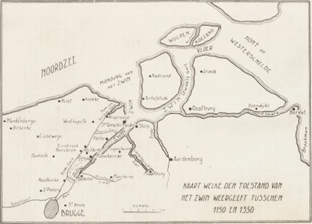
It seems Brugge is still not recognised as a natural harbor, while it was absolutely top notch at the start of the game. The Zwin still went a long way inland back then, while Brugge was far enough from the sea to avoid the big storms.

_vla001193801ill0001.gif
 
  • 11Like
  • 3
  • 1
Reactions:
1. Why are the atolls shown on the map this way? They appear to be large tracts of land, like islands.
2. When will you start recycling sea lanes? In northern Eurasia, there was trade by sea, when local tribes or Russian sailors sailed across the Pechora and Kara Seas to the Yenisei and Ob. And later, the researchers swam across the Taimyr and reached Chukotka.
It seems to me that need to make more sea areas navigable.
 
  • 2Like
Reactions:
I hope you are sarcastic, but in case you missed it the devs have said that any ownable location on the map must belong to a market and that it goes to the closest one, they also stated that market centers can only exist in towns and/or cities and that Sops don't interact with markets, therefore it doesn't matter if the east coast natives are part of the Maya market since it doesn't affect the game
It is actually realistic, though? Mayan artifacts are found across the East Coast all the time that got traded there... Am I incorrect about this?
 
  • 8Like
Reactions:
Untitled.png


Padise needs to be the best harbor in the region. Because Paldiski was icefree (unless weather was super extreme), it was a crucial harbor for St. Petersburg and whole Russian Empire. This importance lasted until 2010s when Ust-Luga harbor was built. But even that harbor can't fully compete with Paldiski, because Ust-Luga quite commonly ices up during some weeks or even months of winter.

Leal (Lihula) was not a noteworthy harbor. Leal does not need any natural harbors.

I didn't mention in the map, but Pärnu can be a duller color green and Wendau (Vetspils) and Riga can have a brighter color for their harbors than very dark green

Narva should have the same color harbor than Tallinn. Historically Reval meddled a lot in order to decrease significance of Narva. For example Reval (Tallinn) didn't allow Narva to get Lubeck city rights. Nor was Narva allowed to join Hansetic League. Only during Swedish Empire Narva was able to show it's true value and was chosen to be second capital of Swedish Empire for a reason.

/edit I checked and Paldiski is older than Peter the Great's conquest. Already during 17th century a harbor was built roughly in the same spot. Paldiski was then known as Rågervik. Afterwards the name stuck for a brief period during Russian rule and was known as Rogerwiek until Catherine the Great ordered it to be renamed to Baltiiski Port. When during 1939 Soviet Union forced Estonia to sign bases treaty, Paldiski became one of the bases for Soviet Army from which they later occupied the whole country. After Estonia regained it's independence there was a risk that Russia would want to stay in Paldiski permanently (like they did in Crimea) but luckily army left 1994. It is rumored that our first president had to make Russian president one sidedly drink a lot of vodka before he was ready to agree to that.
 
Last edited:
  • 12Like
  • 1
Reactions:
It is actually realistic, though? Mayan artifacts are found across the East Coast all the time that got traded there... Am I incorrect about this?
Most likely traded indirectly. There are also Colombian artifacts in Mexico and vice versa, as well as Maya artifacts in the US southwest. It doesn't mean that the trade was direct or there were relations, nor does it mean that'd be they'd "belong to the same market" in game terms.

There is some evidence for Maya trade with Cuba and perhaps Florida, and iirc indirect trade with the lower Mississippi. But the Maya market reaching into Canada is pure comedy.

Anyways like the other guy said, it doesn't affect gameplay too much because Project Caesar pretends you need a state to have trade networks... which I hope will be changed.
 
  • 6Like
  • 2
  • 1
Reactions:
On the map where we can see the sea routes does the colour have any meaning and could we get a key for which direction they are?

Regarding natural harbours, I would consider Liverpool and maybe Bristol (I know it was tidal) for some form of natural habour.
 
  • 2Like
Reactions:
imo the location colour scheme should be changed. It's nigh impossible to distinguish which belong to which province if there are 3 - 4 provinces which have slightly different shades of green, brown or red lumped together

the black stripes in the terrain modes are too distracting, at least give the option to turn them off

dev wise Northern Italy should have slightly less dev (its industrialization process will happen mainly in the first 100 years at game start) while places like Naples should have more (on the account of being the second most populated city in Europe and on account of being right on the sea).

Besides stuff like "Amalfi and Otranto" should be locations (which, yeah they should it's silly having Benevento being one but those not), Ravenna should either have a much natural harbour level or it should have a unique building simulating its infrastructure. Ancona should also have a decent harbour level too (around the same one of Gaeta)

lastly :

Pola should have a natural harbour level equal to Nice (both big inland bays easily defensible)

(also Gaeta looks like it's finally a hill, cause it's surrounded by hilly terrain, yaaaay)
 
Why are modern language names like "German" and "Italian" used when those languages did not exist back in the day? They are artificial languages created fairly recently based upon 'different' languages like the East Middle German dialects/languages and Tuscan. Now it seems like people in 1337 spoke modern German or Italian, when they did not. I would suggest different names for the language/groups, or splitting them up better.
 
Last edited:
  • 13
  • 2Like
Reactions:
It also appears to me that Polynesians are also still split into many religions and Languages, even though it would absolutely make sense as one language (with dialects) and one broad religion
Not sure I agree about the language part, at least on the basis of "mutually intelligible in 1337". Proto-Polynesian seems to have been spoken around 1000 BCE.
 
  • 1Like
Reactions:
It is actually realistic, though? Mayan artifacts are found across the East Coast all the time that got traded there... Am I incorrect about this?
There was definitely trade going on around the carribeans but I don't think it was that "direct" the natives of Maine didn't travel as far south as Mexico as far as I know, it most likely was a chain of trade, like I trade with my neighbour something that he trade with his neighbour that he also traded with his neighbour and so on...
 
  • 5
  • 1Like
Reactions:
Why are modern language names like "German" and "Italian" used when those languages did not exist back in the day? They are artificial languages created fairly recently based upon different languages like the East Middle German dialects/languages and Tuscan. Now it seems like people in 1337 spoke German or Italian, when they did not. I would suggest different names for the language/groups, or splitting them up better.
I would also still feel like splitting "German" into 2 groups would be better, like Niederdeutsch and Hochdeutsch (Low Germanic and High Germanic in English maybe) or whatever term would be most neutral for those languages, using the High German Consonant shift as the line for example. The term I just mentioned for Low Germanic would fit really well in my opinion as the biggest groups of the Low Germanic would be Dutch and Low Saxon (and maybe Frisian, as Low Saxon is closer related to Frisian and English than it is to Dutch or the High German languages), both known for the low laying land. Splitting it into 2 would also show the high diversity of mainland Germanic languages a bit better imo, and make it not seem like 1 giant language blob.
 
Last edited:
  • 7
  • 3Like
  • 3
Reactions: