• We have updated our Community Code of Conduct. Please read through the new rules for the forum that are an integral part of Paradox Interactive’s User Agreement.
Here I make some suggestions for Japan.

Japan had a population of around 73 M. inhabitants in 1939. In the game, it has only 18 provinces on the 4 principal islands (Hokkaido, Honshu, Shikoku, and Kyushu). There is obviously many others smalls territories.

I do suggest for historicity and game purpose to rise the number of provinces. Japan had many important cities.

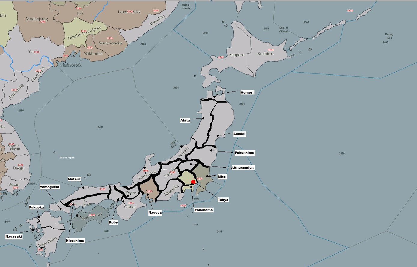
This is the actual DH map of Japan :

DH map of Japan.png


This is the prefectures map of Japan (it was very similar in WWII) :


Prefectures of Japan.png


This the new divisions I do suggest :


New provinces of Japan.jpg


I'll explain the suggested changes in an other post.
 
Last edited:
Here I make some suggestions for Japan.

Japan had a population of around 73 M. inhabitants in 1939. In the game, it has only 18 provinces on the 4 principal islands (Hokkaido, Honshu, Shikoku, and Kyushu). There is obviously many others smalls territories.

I do suggest for historicity and game purpose to rise the number of provinces. Japan had many important cities.

This is the actual DH map of Japan :

View attachment 1274047


This is the prefectures map of Japan (it was very similar in WWII) :


View attachment 1274048


This the new divisions I do suggest :


View attachment 1274060


I'll explain the changes in an other post.


So, for Japan, these changes are proposed :

(All names are important cities in Japan in 1939-1940. I verified cities demographics).

(I have create provinces borders that include 2 or 3 real japanese prefectures)


- To create Aomori province from North Akita province ;

- To expand Akita province in Niigata province - so Niigata is reduced ;

- To expand Sendai province in former Akita province ;

- To create Fukushima province in the southern part of Sendai province ;

- To move Tokyo province at it's real place, and to create Mito province at former Tokyo ;

- Tokyo will be in former Yokohama province (it is there in reality) but is expanded a little bit in former Tokyo province ;

- Yokohama will be in the coastal part or former Yokohame province ;

- To create Utsunomiya from a part of former Sendai and a part of Nagano ;

- To reduce Kobe province ;

- To move Hiroshima province southward an in a part of Kobe ;

- To create Yamaguchi province at the end of Honshu island (form a part of Hiroshima) ;

- To create Matsue province from northern part of Hiroshima & Kobe ;

- To move Kagoshima border northward ;

- To reduce Nagasaki province and to create from it's western part the province of Fukuoka ;


Hence, Japanese population, industries, port, airport would be better distributed. Also, in case of amphibious invasion by US and/or USSR army (it almost happens), the warfare would be more realistic.


There is many suggestions, and I know it would be a lot of work !
 
As a lazy person, I wanted to make minimal edits, but okay, I agree that this area is worth to put more efforts and to make it in more detail and quality!

First, what I disagree with.

1. Krivoy Rog is a unique chess square from which the attacking side can threaten both the northern and southern provinces!
Krivoy Rog is also an excellent logistics hub through which you can quickly move troops along an internal short radius, forcing the enemy to move along an external long radius.
Therefore, Krivoy Rog in no case should be blocked to the direction to Dnieper - this deprives the attacking side of the unique tactical advantage of this province.

Thus, we cannot expand the new Dnepropetrovsk in the north, we must expand it only to the south, including the zone of Nikopol. Nikopol is not needed to avoid creating two provinces that are too small.

And I support other suggestions.

2. Yes, the creation of a new province of Kremenchug is the only right decision. And a very good decision!
The only thing I want to fix, I sure is that all three provinces of Lubny - Kremenchuk - Pavlograd should have the same threat - two attacking vectors for each province.
This creates the right tension for the defending side throughout the Dnieper River and also corresponds to realism/history.

The success of the German breakthrough of the Dnieper in the Kremenchug zone was achieved not by concentration of efforts (not a "strike from three directions"), but by false actions and deception.
For too long, the Soviet command believed that the main direction of the Dnieper breakthrough was in the Cherkassy area, and the pressure in the Kremnchug area was just a distraction.

Accordingly, it will be right if we keep this tension to the Lubny of two atack vectors. Moreover, the real German attack through Kremenchug was directed to Lubny.
That's why I made exactly this form of Kremenchug - so that there would be 2 attacking vectors per defending province along the entire this Dnepr line.

I did not correct the Kremenchug-Pavlograd border to a more visually beautiful one, just because it follows the contour of the official border in the region.

3. Zaporozhye! Yes, it's very good that you reminded about the wrong Zaporozhye! I completely forgot that vanilla Zaporozhye is also a very ridiculous mistake - vanilla Zaporozhye blocks direct access from Melitopol to Mariupol, it definitely had to be fixed!! I completely forgot about it!

The addition of Berdyansk (it became 'Osipenko' only in 1939, so we'll leave the natural name Berdyansk) solves this issue. But it is probably desirable for modders to set as coordinates of this provincee not Berdyansk, but the road junction to the north from Berdyansk, because the attack on Mariupol can be conducted from Melitopol bypassing Berdyansk, directly.

Also, since we are adding Berdyansk, this is a good reason to change the shape of Melitopol and add the Molochnaya River, which was part of the German defensive line and where severe battles were fought in 1943 to break through the German defenses on this river.

4. Well, let's add true Kherson and also create cross-connection in one point for more easy moving around inner radius: Kherson - Dnepropetrovsk and Krivoy Rog-Melitopol.

View attachment 1274040

##################

I would also like to raise the issue of transliteration of the Russian rough sound 'H' in the names of cities.

Not so long ago, I accidentally watched a YouTube video that criticized the accepted transliteration of the Russian rough 'H' as 'KH'. I completely agree with this criticism. I also think this weird 'KH' sounds very ridiculous and cringe.

So, just my strange idea - what if to use 'KH' only if it stay at the beginning of the word - Kharkov, Kherson, but to use just 'H' if it is in the middle of the word - Kahovka, Shahty ?

Just 'Kakhovka' makes me choke. :D
I see the points and i'm fine with them. Good additions.
 
[Maps deleted]

Kust want to share todays adjustments. No big spectacular effects.
ITALY:
I think I will stay with Rimini in this version. But hey. I'm not mapping so its just a suggestion and no "final call".
I adjusted Venice and Pola to get a bit closer to terms of size and historical "relevance" (Fiume).

FRANCE:
NEW: Voix - Thx @tioperete for his hints and additions here.
NEW: Vannes was added for the reasons @tioperete had added; prevent easy britanny cutoff.

GERMANY:
The area of the upper rhine between Stuttgart and Darmstadt was adjusted.
Adjusted: Karlsruhe is now Heidelberg; sits in the center of the province and had more relevance compared to Karslruhe.
Adjusted: Heilbronn moved a bit to the center and had take some space from Nürnberg so make the area a bit smaller.
Adjusted: Ulm was moved a bit to cut a small piece from Nürnberg too.
Adjusted: Lüneburg should be a regular gras land terrain; it was one of the training areas of the Panzerwaffe and the Heide is a beautyful (cant wait to get back to Munster soon) and its far of a swamp.
 
Last edited:
  • 1Like
Reactions:
1000066065.jpg

Am thinking about giving Puigcerdá salient to Urgell province. It's true that administratively it's part of Gerona, but direct road go from La Seo to Perpiñán via Llivia valley. Puigcerdá is 40km from La Seo and 144km from Gerona, that would allow a double attack route to Perpiñán that's accurate, and not force to go there through Gerona. Perpiñán is 150km from La Seo and 97 km from Gerona, forcing to pass Gerona would mean La Seo to Gerona 176km+97km=273km, nearly doubling the time needed to reach there.

And I noticed one thing. The map uses the castilian names for the Spanish cities, so then is La Seo de Urgel, the other name was in catalan.
 
Karten rework EU concept (1).jpg

-La Seo de Urgel modification, explained in a post before.

-Revised some things around Brittany: Nantes lies north side of the Loire. Vannes adition was my idea and I think a nice one, but taking into account the wrong Nantes location maybe would be more interesting just expanding St Nazaire and relocate Nantes to her true position. You can see the roads in blue, with a light blue way from Vannes to Angers that it's just little roads connecting villages. That would mean adjusting also La Rochelle area of influence, (which should have direct way to Bordeaux without passing by Angouleme in the south) a bit to the North, and making old Nantes province La Roche-sur-Yon. Not all I said here painted in the map.

-In the Western Alps, I missplaced Grenoble a bit to the south, but I saw Cuneo is maybe not fit for its role and Susa would be maybe a better name por the province, as it is nosense to force the way from Chambery to Torino by Cuneo. Susa pass to Chambery by Moncenisio usually is closed in winter. Having 2 different provinces, Susa and Cuneo, would fit, but I prefer not to go for too much litlle provinces except strictly necessary. Also from Susa you have the Briaçon pass to Grenoble, this one I didnt paint in the map, also closes in winter. Both passes were used to invade France.
The connection between Cuneo and Nizza can be closed in winter, but it was used by the 5a Div. Cosseria to attack and invade towards Mentone.
From Grenoble to Nizza, Grasse road should be rarely closed in winter.
Chambery to Sion is closed in winter and a very bad route, except you go via Geneva, issue is that you don't have to enter the city properly as you can border Lac Leman avoiding Swiss territory, but it has to be taken into account for calculating distances.
Bern should have direct way to Belfort, I thought about adding Basel as a mandatory pass from Bern and Zurich to Alsace. Also thought abut Lucern as an axis between Basel-Zurich-Bern-Lugano but at the end discarded the idea as it would be redundant, anyways something to discuss if it contributes or not.
Modified Dijon to accomodate better its position as mid point between Le Creusot and Belfort.
Removed Pontarlier salient, nosense and direct road from Bourg to Geneva. Also think Pontarlier should be discarded and changed to Besançon, whose location is marked in purple/yellow.
All these Alpine road and passes issue would be wonderfull if DH devs implemented a feature that allows some border crossings be dependant on climate.

- in the Eastern Alps, modified Kranj-Maribor border to force Kranj to Zagreb route go through Ljubljana or Maribor.
I made Graz connect directly to Gyor and Zalaegerszeg by taking a part of Eisestadt, and divided Leoben from Graz, maintaining Leoben as mountains and making Graz hills.
Also I propose to create Varadzin from Bjelovar and give part of Osijek to Bjelovar, making Varadzin plains and Bjelovar hills, maintaining the forest in Osijek.

-in the Tatras, removed the way from Brno to Zilina, but rethinking I did not develop Slovakian lands as much careful as Alps or Greece. Trencin and Nitra as distributors should work, specially Nitra as hills and moving a bit Banska Bystrica eastwards. Some extending of the Tatras taking part from Presov province would be nice. Something to consider is adding Proprad there ass a pass from Zilina, Banska Bystrica and Zakopane to Presov.

-in Poland, moved Krakow to its correct side of the Vistula, making also its connections more logical, and renaming old Krakow province to Zakopane. These way we hace Krakow as city terrain and maintain the Tatras mountains as Zakopane. Katowice would become plains, in 1936 I don't see a justification for it to be city terrain.
Added Baranowicze cause logistical and importance reasons, but possible limits should have to be discussed as it would be Poland-USSR border.
Added Rzeszow in the map but maybe it's not that neccesary.

In Tuscanny, when I proposed Grosseto I was thinking about a mid point from Tuscany to Rome, taking part of southern Tuscany and northern Lazio. Some border ideas and cuts there, nothing clear. When Rodolphe proposed Lucca to make Florence inland, I thought the obvious choice was Pisa, not Lucca. But we added La Spezia as a main port and fleet base, so adding Pisa would maybe overcrowd the area. We can also maintain a port in Florence representing Pisa.
But I think keeping Livorno, as a coastal fortress and main port of Tuscanny, is a good idea, while Grosseto would fill the initial role I thought for it.

-In Bulgaria moved Plovdiv to its correct side of Maritsa river taking half of Haskovo. Renamed old Plovdiv to Stara Zagora. Sofia province would need little correction to make visual connection to Plovdiv a bit bigger. Plovdiv to Kavale connection not avaliable cause the Rhodope.

-in Macedonia and Greece, first one is the complete missplacdment of Lake Ohrid.
Stip and Bitola added. Stip can be maybe innecesary, I'd like to know your opinion guys, but think Bitola is interesting, specially taking into account the logistics and Greece rework with the impassable terrain towards Veria.

-in Greece, I reworked the Metsovo-Kozani mess, by dividing it into mountains Kozani and Trikkala, and Veria, which terrain I dont have clear.
Lamia new province ass a pass from Agrinion to Larissa and to force the way from Trikkala to Agrinion by it or Ioannina, and also an extra barrier to protect Beocia (Lebadea) and Atica (Athens).
In the Pelepponese, 1 or 2 cuts. Corinth as the key pass to Patras and the rest of the peninsula, that could be Napflio and Kalamata, or just Kalamata.
 
Last edited:
Here, some suggestions for Persia.

The country is important has it was occupied by USSR & UK/USA in order to supply USSR during the war. It is also a gateway toward Irak, India, Caucasus, Turkmenistan.

- I suggest to create Semnan province from east part of Mashhad ;

- I suggest to create Gorgan from east part of Sari ;

- I suggest to expand a little bit Sari povince in Rasht province ;

- I suggest to create Zanjan province from south of Tabriz ;


View attachment 1272185


I suggest a better and more realistic way to represent Persia/Iran.


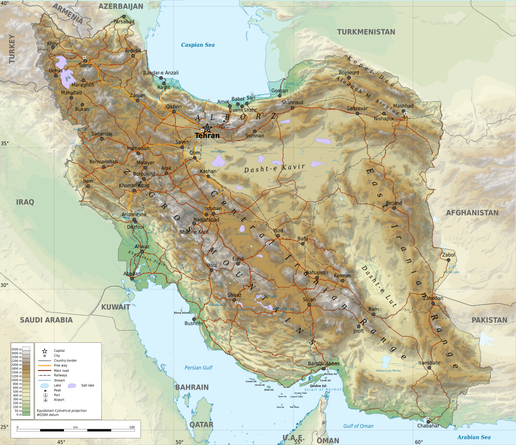
This is the geographical map of Iran :


Iran-geographic_map.svg.png


This is the territorial divisions of Iran in 1936 :


Capture d’écran 2025-03-31 203417.png


This is the geographical map of Pakistan :

1024px-Pakistan_relief_location_map.jpg


This is the map that I propose for Iran mostly and one modification to Pakistan:


Iran-Pakistan map changed.jpg


In Pakistan :

- I suggest to add a coastal province (Gwadar), at southern part of Gwadar (There is a passage along the coast from Irak to Pakistan), and to rename the northern part Turbat ;


In Iran :

- The 3 provinces south of Caspian Sea are like in reality - they are plain or hills ;

- The new divisions from Irak to Afghanistan would include 2 or 3 real provinces each ;

- The artifical division of Rezaiye would be maintained ;

- The provinces of Mashad would divide in 2 for game play (it was somehow a real division North and South Khorasan) ;

- Kerman province would divide in 2 for game play (it was somehow also real division = Baluchistan) ;

- At the Persian Gulf, 4 coastal provinces would be created to represents the coastal plains and Hills ;


Overall, for historicity and gameplay, it would be better !
 
Last edited:
(There is a passage along the coast from Irak to Pakistan),
It will be interesting to see the evidence.
Show any WW2-era map with this road. I haven't been able to find it yet.

And in general, in Iran, I can expect a certain number of blocks between provinces, because of the lack of roads, you don't have any.
WW2-era roads map of this area needs to determine this.

1922 map
https://www.britishempire.co.uk/images2/middleast1922map.jpg

1931 map
https://joyreactor.cc/post/2456885

It will be interesting if you find more old maps of this region, to research the road network.
 
Last edited:
It will be interesting to see the evidence.
Show any WW2-era map with this road. I haven't been able to find it yet.

And in general, in Iran, I can expect a certain number of blocks between provinces, because of the lack of roads, you don't have any.
WW2-era roads map of this area needs to determine this.

1922 map
https://www.britishempire.co.uk/images2/middleast1922map.jpg

1931 map
https://joyreactor.cc/post/2456885

It will be interesting if you find more old maps of this region, to research the road network.

Well, I dont know at all if there were a road along the coast.

However, most of map that I have looked indicated plains and hills all along the coast from Irak to Pakistan. So it is easier for infantry or cavalry units to invade or move along the coast instead of the mountains.

Persia is a big country and it was invaded quickly by motorized forces of USSR and UK, so they were many roads from all axes.

I will consult some encyclopedia regarding roads and mountains pass and I will be back !
 
I suggest a better and more realistic way to represent Persia/Iran.


This is the geographical map of Iran :


View attachment 1274786


This is the territorial divisions of Iran in 1936 :


View attachment 1274792


This is the geographical map of Pakistan :

View attachment 1274788


This is the map that I propose for Iran mostly and one modification to Pakistan:


View attachment 1274789


In Pakistan :

- I suggest to add a coastal province (Gwadar), at southern part of Gwadar (There is a passage along the coast from Irak to Pakistan), and to rename the northern part Turbat ;


In Iran :

- The 3 provinces south of Caspian Sea are like in reality - they are plain or hills ;

- The new divisions from Irak to Afghanistan would include 2 or 3 real provinces each ;

- The artifical division of Rezaiye would be maintained ;

- The provinces of Mashad would divide in 2 for game play (it was somehow a real division North and South Khorasan) ;

- Kerman province would divide in 2 for game play (it was somehow also real division = Baluchistan) ;

- At the Persian Gulf, 4 coastal provinces would be created to represents the coastal plains and Hills ;


Overall, for historicity and gameplay, it would be better !
1000066083.jpg
 
  • 1
Reactions:
However, most of map that I have looked indicated plains and hills all along the coast from Irak to Pakistan. So it is easier for infantry or cavalry units to invade or move along the coast instead of the mountains.
On Google maps, I see only one road there, and it runs through rocky, lifeless deserts. I don't see many beautiful plains there. It all looks like an extremly unfriendly desert lands.
And I haven't been able to find this road on old maps yet, so if we don't see the road there on old maps, there's no reason to think it exists.
Yes, probably a camel caravan could pass through there with no road. But not division with vehicles.

By the way, a part of Iran also is on 1942 soviet map
http://map.etomesto.ru/base/99/euro-1942-04-20-rkka.jpg
 
Last edited:
Last edited:
Well, there is a road on this map, then we have a reason to connect these provinces.
Interesting, what year is this map?

Well,

I give you a truckload of roads and railways :


- Road & Railways in Iran in 1939 :
(According to this map, there is a road along a part of the Persian gulf coast (but not all along) :

Road & Railway 1939 Iran.png


- Irak & Western Iran 1941 :


Iraq and western Iran in 1941.png


Persian Gulf Command during WWII :

PersianGulfCommand.jpg


Map of allied invasion of Iran in 1941 :


Allied_Forces_Sweep_on_in_Iran.png


- Roads and Railways in Iran in WWII :


Road & Railway WWII Iran.jpg


- The TransIran railways in 1938 :

Transiran_railway_en_1938.png


- Allied road and rail supply lines through Persia into the USSR :


Allied road and rail supply lines through Persia into the USSR.jpg
 
Last edited:
Well,

I give you a truckload of roads and railways :


- Road & Railways in Iran in 1939 :
(According ti this map, there is a road along a part of the Persian gulf coast (but not all along) :

View attachment 1274934


- Irak & Western Iran 1941 :


View attachment 1274930

Persian Gulf Command during WWII :

View attachment 1274931

Map of allied invasion of Iran in 1941 :


View attachment 1274932


- Roads and Railways in Iran in WWII :


View attachment 1274933


- The TransIran railways in 1938 :

View attachment 1274935


- Allied road and rail supply lines through Persia into the USSR :


View attachment 1274936

The problem is that all these maps do not contain a coastal road connecting Iran and Pakistan.

Only the map from tioperete contains this road on the map. Unfortunately, there is no map legend and it is difficult to understand whether is it just a camel trail or a truck-accessible road. At least on the Soviet maps, camel trails and trucks roads differ graphically. But unfortunately the Soviet map did not include this most interesting part of Iran.
 
Last edited:

Vilochka

So, the next set of technical specifications )

To finish previous edits:

1. Since our plans have changed towards more work, let's systematize the work with donor IDs - we will use free IDs only in the same country, this should make it easier for modders to integrate the Map.

2. Rename:

Volgodonsk - Zimovniki (this town still did not exist in this era)
Morozovsk - Morozovsky
Kotelnikovo - Kotelnikovsky

3. 583;588;Delete (delete Bryansk - Yefremov at the map level)

4. 645;662 to make visual connecting Konstantinovsk-Kotelnikovsky

5. To draw a tactical river (Samur) along the Makhachkala-Baku border, this border is exactly this river in it's form. I forgot to say this before.

6. And, please, please, make Moskva river not straight as a channel, but curved, like I showed before.

-----------------------------------------

7. To make new edition of lower Dnepr zone and to split Rostov like this

Dnepr area.jpg


8. To make South/Central Ukraine like this:

Ukraine.jpg

Thanks!!

Do it at your own comfortable pace, there is no rush. :)
 
Last edited:
  • 2
Reactions:
Well, there is a road on this map, then we have a reason to connect these provinces.
Thanks for the map! Interesting, what year is this map?
1930, english editor Philips
 
  • 2
Reactions:
Edited Post #187 worth to take a look at it
I will check most of the post tomorrow with more time.

Short note:
Italy:
I would prefer to keep the name "Cuneo" for historical reasons; The Cuneo province was one of THE centers of italian Aplini recruitment. One of the core training regiments was palced in Cuneo and here Alpini got most of their ski training. So the name is standing for a military tradition and an italian elite corps so I think it would be a shame to drop the name. You can always think of different geo coordinates sure but I think when we have a "military" name for a military game we should keep it.

France:
The Pontalier salient (and the province) was made for a historical boarder with Vichy. When my memory is correct Guderian rushed to the swiss boarder in 1940 near Pontalier. His first task was the cutoff off of french forces in the north. But when my memory is correct the german military administration want to keep the area under its control because here there were road and railroad networks that were used by the germans to trade good from swiss. So it was a logistical reason to keep control over a place that was rated as strategic important.

Poland:
I though Kraków was already on "both" sides of the Vistula? So I guess there are arguments for both sides. With a "northern approach" it would help to close one of my voids/gaps in the layout. I will think about it.
For Katowice; I think it was made an urban area because it was a sort of an industrial core region? From my memory I thought the germans were call it "the polish Ruhrgebiet"; a place filled with heavy industry and mines and factories. After the fall of Poland the Upper Silesian industrial area repalced the western Ruhrgebiet as military powerhouse because the spot was save from allies air raids for a long time plus coal and iron ore were already available in the area reducing logistical stress.
So I think it could keep its special status.

For the rest; I will look at it and try to implement most elements. I like most of the additions.
I like the idea about setting the coordinates between Cuneo and Susa for distance calculations.

Didnt think about Vichy borders, but the truth is that salient cuts the road between Bourg and Geneva XD. So there we have an administrative borders problem that ruins the logistics there, as creating Oyonnax micro province there would be an undesired solution. In any case, I'm still in favour of removing it. We have more examples in the game of non exact borders to avoid micro provinces, like Prekmurje (Murska Sobota), the strip of Sobrance, Jaanilinn-Ivangorod and Petseni area in Estonia, Abrene area in Latvia or the penisula of Hanko.

About Krakow, it's true that nowadays it lies in both sides of the river, but at the time there were two different cities, Krakow in the northern bank and Podgorze in the south.
Katowice was heavy industrialized and its true its surroundings are full of villages, but see the maps, dont think these one fits into big city. Anyways, if Katowice is maintained as city, should we make Krakow city also and have a big urban area?
1000066186.jpg
 
Last edited: