View attachment 1273476
Changes:
SPAIN:
New: Sabinanigo added for a Pyrenean flank and to adjust the provinces further south.
New: El Pont de Suert added; the partisan region that was captured by anti-franco forces in 1944. Added to adjust Lleida further south.
Adjusted: Huesca changed to a hill and cutted down in size.
Adjusted: Lleida was changed to a hill terrain type and cut down.
FRANCE:
NEW: Bayonne added.
Adjusted: Old Agen renamed into Auch.
Adjusted: Toulouse was made smaller and turned into a urban terrain type.
Adjusted: Beziers was adjusted by adding the Carcasonne area and to cut down Toulouse.
New: Montauban was added to absord the rural region around Toulouse and to get a split between the town and the large rural area.
New: Nimes was added. Nimes was an important crossroad town and a garrison town.
New: Montelimar was added; the gate to the south and the last stand of Hrg. G in 1944 before the mass retreat started to the Metz area way north.
Adjusted: Rodez was adjusted for Nimes.
Adjusted: Montepellier was adjusted for adding Nimes.
Adjusted: Avignon was adjusted to add Montelimiar.
Adjusted: Grenoble was made a bit smaller to get in the "Gate to the south".
Adjusted: Valence was moved a bit north.
Adjusted: Bourg-en-Bresse was moved a bit.
> both changes were made to get a more cohesive design in the area.
ITALY:
New: Terni was added to get the Rome hill flank and to get an addtional road around of Rome.
Adjusted: Rome was adjusted for Terni.
Adjusted: Livorno was changed to Grosseto and changed to a forrest region to get a contrast to the Apennine Mountains. The region was adjusted for Terni.
Adjusted: Perugia was shrinked in size for Terni.
New: Verona was added to get a more destintic split in the area.
Adjusted: Venice was made smaller for adding Verona.
Swiss:
New: Sion was added to get in the Rhone river cut and to fit more to the geographical area markings.
New: Chur added as a new alpes province to get swiss more room to move.
Adjusted: Bern has lost territory to Sion.
Adjsuted: Geneva has lost territory to Sion.
Adjusted: Lugano was vut in half for Chur.
Slovenia:
New: Kranj was added to get a split in contrast for the "Maribor gap".
Adjusted: Maribor was changed to a hill terrain type and lost parts to the new Krani area that is a mountain terrain.
Hungary:
Adjusted: Pecs was made smaller.
Adjusted: Szekesfehervar aka Stuhlweißenburg was moved a bit on its southern boarder for the historical "battleline".
New: Sziofok was added for a historical cut in the hungarian lake Balaton flat lands.
Adjsuted: Szeged was reduced.
Adjusted: Miskolc was adjusted in size to reduce the "hill area".
New: Szolnok was added as a new cut infront of Budapest. The province should allow more movement infront of the town for a potential forces buildup.
POLAND:
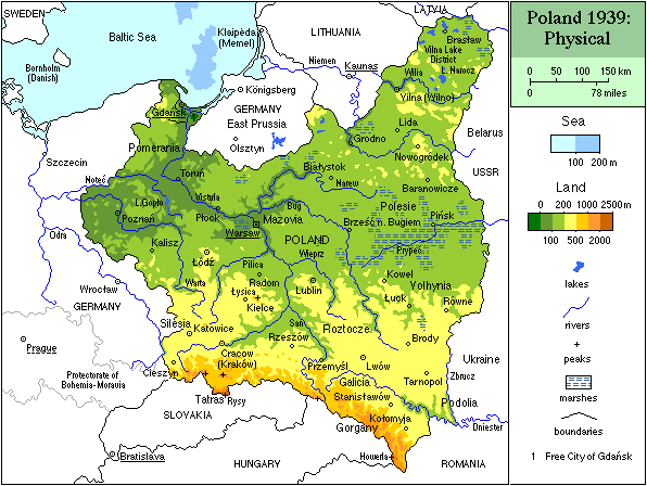
First of all: I'm not that happy with Poland. The entire Lodz-Radomsko-Radom-Kielce-Czestochowa-Katowice area is a clusterfu** and heavy to solve because of the natural terrain that is heavy shaped by the rivers in the area.
Adjusted: Gdynia was adjusted.
Adjusted: Bydgoszcz was adjusted. Together with Gdynia the front was made a bit smaller.
Adjusted: Torun was adjusted to allow the direct german cut. The province is now a bit too big but I dont get a better cut.
New: Ciechanow was added as boarder province and to add a step before Warsaw to allow a bit more delaying action.
Adjusted: Plock became Modlin; the historical fortress that protects Warwas for ages now. The Province will now serve as a fortress area.
Adjusted: Old Wloclawek is not Kutno; a cross town at the road Torun-Lodz-Torun-Warsaw.
New: Wloclawek was added to the mix to allow an alternative polish retreat road.
Adjusted: Poznan was made smaller to allow the historical bypassing of the province via Kalisz.
New: Kalisz was added to add a bypass and cut to Pozan.
Adjusted: Czestochowa was made smaller to get a direct one-to-one boarder to Gleiwitz for a marching route from Gleiwitz to Radom by bypassing Lodz.
Adjusted: Katowice was made a bit bigger to close the gap of "no mans" land between Krakow-Katowicz-Kielce-Radomsko.
Adjusted: Sosnowiec moved north and became Radomsko; a cross town on the road Breslau-Kielce and Czestochowa-Warsaw-
Adjsuted: Lodz was made smaller to add the "warwas buffer zone".
Adjusted: Radom became smaller to get a flat terrain southern route to Warsaw - the route preferred by german armor...
Adjusted: Krakow became smaller by moving the vistula river a bit more into the mountain area.
Adjusted: Tarnow became a forrest area with a river crossing to Krakow.
New: Kielce was added to get the more kill dominated land south of the flat lands of Radom.
Adjusted: Nowy Sacz has a part river boarder. Its just a visual change.
Adjusted: Przemysel turned into a forrest.
Thats all for now....
Poland is a real nightmare to its river dominated lands...


