• We have updated our Community Code of Conduct. Please read through the new rules for the forum that are an integral part of Paradox Interactive’s User Agreement.
I find the borders between West Prussia and Posen, as well as West Prussia and East Prussia to be a bit wonky.
My suggestion would be to more or less do the following:
1666801462685.png

Basically transfer that weird protruding bit of land to the west to Posen, and shift the border betwen East Prussia and West Prussia a bit to the west. For that bit, I think it would be fine to use the pre-WW2 border as a reference(Just include Gdansk/Danzig with WP):
1666801565765.png
 
  • 4Like
  • 1
Reactions:
Please add alternate flags for formables ! it is a simple yet powerfull tool to reward players who play minor nations ! having a Saxonian germany flag and tuscan italy for example would be very cool
A lot of formables don't even have more than a couple alternate flags for their ideology either, which is kind of disappointing.
 
  • 3
  • 2Like
Reactions:
Juneau, Alaska is supposed to be on the southern coast of Alaska instead of on St. Lawrence Island.
 
The borders of Argentina, Bolivia, Chile and Paraguay are wrong. The countries can't have the correct current borders with the way states are divided.

An entire province of Argentina is misplaced.
Formosa.jpg


The two parts highlighted belong to the same state in game, but one is now part of Bolivia and the other of Argentina.
Jujuy.jpg


It's impossible to correctly divide the Argentinean and Chilean side here.
Tierra del fuego.jpg
 
Last edited:
  • 3
  • 1Like
  • 1
  • 1
Reactions:
The town "Kraljevo" in the state Northern Serbia was named Karanovac in 1836. It was renamed to Kraljevo in 1882 in honour of the new Serbian king Milan Obrenović.

Anyway, my suggestion is to place Kragujevac on the map instead of Karanovac/Kraljevo:

- it is 50 km away
- it was (and still is) a larger settlement
- at the starting date, it was actually the capital of Principality of Serbia (capital was moved to Belgrade in 1841).
 
  • 3
  • 1Like
Reactions:
Brazil needs Espirito Santo State!
 
  • 1
Reactions:
The map situation in Ghana/Togo doesn't make an awful lot of sense, and it includes one glaring mistake.

In the game Great Britain starts the game controlling Accra, but they did not buy Christiansborg from Denmark until 1850. Thus, in 1836 Accra is Danish.

Denmark controls Lomé, the current real life capital of Togo. Denmark held interests and forts in that area, but they were not as important or extensive as Christiansborg. Accra was the Danish seat of power in West Africa, not Lomé.

The Brits did however own an important fort in Ghana in 1836: Cape Coast Castle.

The easiest way to resolve the Ghana/Togo map is to give Accra to Denmark and create a Cape Coast province for the British.
 
  • 3Like
  • 1
  • 1
Reactions:
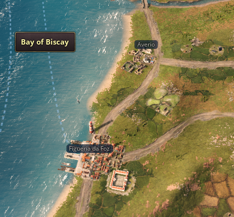
Portugal has a few misses:

- Lisbon is on the wrong side of the river:
1666813055244.png
1666813149677.png


- Two typos and a wrong Ocean:
1. Figueria da Foz instead of Figueira da Foz and Averio instead of Aveiro;
2. Portugal is on the Atlantic Ocean, not the Bay of Biscay
1666813210378.png
1666813310137.png


- In relation to Porto and the Douro river, Braga is not as inland nor as East as depicted:
1666813497868.png
1666813544644.png


- The Azores (Açores) are missing an island (only 8 on the map, but the archipelago has 9 (yes, that tiny spec in the West):
1666813706169.png
1666813766668.png


- Porto Santo is too large in relation to Madeira:
1666813847036.png
1666813872235.png
 
  • 2Like
  • 2
Reactions:
Have you stumbled across an area of the world that is not looking as you’d expect it to? For instance, are the borders slightly off, or is it populated by cities that should not exist at the time period of the game? Or do you simply have suggestions for improving the map?

Document them here! We will do our best to investigate it further!
Screenshot 2022-10-25 162046.png


Three things concerning Montenegro:

1. It didn't have access to the sea at the time. It only gained it through two ports(Bar and Ulicnj) at the congress of Berlin in 1878.

2. Podgorica wasn't it's capital at the time. Cetinje was it's capital at the time.

3. It should be a vassal of Ottomans like Serbia. It recieved it's independence during aformentioned congress of Berlin, along Serbia and Romania.
 
  • 3Like
  • 3
  • 1
Reactions:
New Zealand's got a few issues.

Wellington didn't exist in 1836 - it was founded in 1839 and not named until 1840. It was lightly settled before then though.

Auckland also wasn't founded until 1840 - although it was more heavily settled than Wellington. That said, the city would have looked more like a collection of tribal villages and Pā built from wood and flax rather than a European-style port as we see in 1836. This applies to Wellington as well. I've included a picture below of the European-style city that the United Tribes control.

Finally, and I hate to say this because they look so pretty... NZ's littered with lighthouses in the game. The first lighthouse in NZ was built in 1858.
A very minimal effort fix would be to rename Auckland “Tāmaki” and Wellington “Pōneke”.

Don’t have access to the game at the moment but can provide Reo names for other cities if needed.
 
  • 1Like
Reactions:
The town "Kraljevo" in the state Northern Serbia was named Karanovac in 1836. It was renamed to Kraljevo in 1882 in honour of the new Serbian king Milan Obrenović.

Anyway, my suggestion is to place Kragujevac on the map instead of Karanovac/Kraljevo:

- it is 50 km away
- it was (and still is) a larger settlement
- at the starting date, it was actually the capital of Principality of Serbia (capital was moved to Belgrade in 1841).
I would also suggest city of Šabac: https://en.wikipedia.org/wiki/Šabac#History

It was quite important Serbian city during the Victoria 3 period, especially after the Serbian independence from the Ottomans, as a lot of Serbian trade with Austria went through that city.
 
  • 1Like
Reactions:
Very puzzled by the choice to name the three main states in the South Caucasus (aside from the bit of Kars): Armenia, Azerbaijan, and "Greater Caucasus" when the state of Greater Caucasus corresponds pretty precisely with Georgia, a name which was used for this area during this time frame. Granted, there was no unified kingdom of Georgia when the Russian Empire invaded the South Caucasus (prior the the game's time frame), but neither was there unified kingdoms of Armenia or Azerbaijan at the time.
 
  • 7
Reactions:
Have you stumbled across an area of the world that is not looking as you’d expect it to? For instance, are the borders slightly off, or is it populated by cities that should not exist at the time period of the game? Or do you simply have suggestions for improving the map?

Document them here! We will do our best to investigate it further!
Yeah, the entire ethnic map
 
  • 3
Reactions:
Very puzzled by the choice to name the three main states in the South Caucasus (aside from the bit of Kars): Armenia, Azerbaijan, and "Greater Caucasus" when the state of Greater Caucasus corresponds pretty precisely with Georgia, a name which was used for this area during this time frame. Granted, there was no unified kingdom of Georgia when the Russian Empire invaded the South Caucasus (prior the the game's time frame), but neither was there unified kingdoms of Armenia or Azerbaijan at the time.
Weren't Abkhazia, Mingrelia, and Svaneti also still independent, or at least not fully incorporated into Russia during this period?
 
The city of Oldenburg is actually the city of Osnabrück, while the city of Oldenburg should be a lot further north.
Emden technically isn't on the north sea, as it's on the estuary of the Ems, which is on the west of East Frisia instead of the north.
 
  • 3Like
  • 3
Reactions:
Have you stumbled across an area of the world that is not looking as you’d expect it to? For instance, are the borders slightly off, or is it populated by cities that should not exist at the time period of the game? Or do you simply have suggestions for improving the map?

Document them here! We will do our best to investigate it further!
In New South Wales there is a town called 'DUBBA' on the map. The correct name is 'DUBBO'. Also in NSW, Canberra is shown and that city was not established until 1913.
 
  • 2Like
  • 1
Reactions:
Hi, I am from Paducah, Kentucky. In EU4, there is a westernmost province within Kentucky that is named Paducah if controlled or owned by a nation of British culture. HOWEVER, Paducah, a city originally settled around 1821, and formally incorporated in 1830, and which sat at or near four rivers (Ohio, Mississippi, Tennessee, Cumberland) and is relatively mid-way between Chicago, St. Louis, Louisville, and Nashville (the latter of which aforementioned Cumberland River passes through), is not shown on the map. It is from the presence of four rivers nearby that Paducah had developed a considerable river industry complete with dry-dock facilities and such.

Paducah also sits at a junction of railroads from Illinois (Illinois Central Railroad, incorporated in 1836 but apparently operating from 1851 until 1999 when it was acquired by Canadian National Railway) and from Louisville (a line formerly owned by Illinois Central; now known as Paducah & Louisville Railway). It was of such importance in the railroad industry that it had the works and the shops built in the city to serve the railroad networks there, most of them built before 1936. Illinois Central even had a hospital built for railroad workers (now called Katterjohn Building and which was disgracefully left in ruinous state by its present owner at the time of this writing). The legacy, the impact, and heritage of the river and rail industries together in the city are such that the city now have museums dedicated to them (River Discovery Center and Paducah Railroad Museum, respectively).

Moreover, its strategic importance can be seen in the fact that it was the first town in the then-neutral border state of Kentucky during the American Civil War (Note 1) that was occupied by then-unknown Union army general Ulysses Grant, who would later rise to fame, in response to the occupation of Columbus, Kentucky, by Confederate general Leonidas Polk (an act that arguably violated the neutrality of Kentucky). It was from this town that Grant would eventually launch the invasion that culminated in the capture of the forts at Columbus and Belmont, Missouri, the latter opposite across the Mississippi River from Columbus.

Furthermore, the city had population of over 33,000 by 1930, six years before the end of the timeframe covered by Victoria 3. And this is despite the great floods of 1927 and 1937 (though, the latter is obviously just shy beyond the Vicky 3 timeframe). Frankly, I think that, given its geographic location as I described above, it was almost inevitable in any alternate history to become a city of significance. Its continuing significance today can be seen much later in that the Interstate 24 which passed through Nashville was routed and built near the city at its inception in early 1970s.

Today, its population is now 27,000; while that was a decline from the 1960 peak of over 34,000, its continuing significance meant that it did not suffered the dramatic decline that the nearby city of Cairo, Illinois (which sat on confluence of Ohio and Mississippi River) suffered (whose population is now a bit over mere 1,700, a stark contrast to its 1920 peak of over 15,000). (Note 2) Moreover, the decline in Paducah's population in last several decades masked the continuing importance of the city in that the county it is part of (and the seat of), McCracken County, contained a population of over 67,000 (and which actually had been growing during the same period in contrast to the city, a situation not unlike most of their big-city peers whose population was lost to the suburbs surrounding them) and that it is the hub of Paducah micropolitan area with a population of over 98,000. (Note 3)

Finally, a fun fact: there is also Paducah, Texas, that were apparently named by the settlers who came from... wait for it... Paducah, Kentucky!


NOTES

Note 1: Kentucky, as one of the four border states and on account of its location, was apparently so critical to the war that Abraham Lincoln said "I think to lose Kentucky is nearly the same as to lose the whole game."

Note 2: The dramatic decline of Cairo, Illinois may be attributed to the construction of bridges, in 1905 (railroad) and 1929 (road) respectively, nearby that by-passed the city and to the opening of Interstate 57 (which, by the way, is connected to aforementioned Interstate 24) in 1978 which also by-passed Cairo.

Note 3: Paducah actually had its population increased recently for the first time according to 2020 census, a reverse of the trend that had been ongoing for over four decades since 1970 census when it begin to show decline. Moreover, none of the declines in the U.S. censuses shown for Paducah, Kentucky, were double-digits unlike that of its peer Cairo, Illnois. The latest increase in city's population may be largely due to the ongoing city renaissance efforts that emphasized revitalization through the arts and the culture that centered around its status as the Quilt City (with the national quilt museum) and the Artist Relocation Program in its Lower Town district. It is from these efforts that resulted in the city gaining the UNESCO Creative City designation, a rare honor indeed for a city of its size.
 
  • 2
Reactions:
I was delighted to see a topic concerning correcting maps in Vic 3!

I would suggest revisions to the area around New York Harbor. For being such a crucial economic and industrial hub, the map in Vic 3 is lacking in details. I understand that with Manhattan being relatively small compared to the region, it may be difficult to get everything in game. However, I do think having the Hudson flow out into the Atlantic Ocean instead of being blocked by long island (which is not an island in game) would be more realistic.

Also, I am unsure if the Erie Canal is (or even can be) represented in game, but it definitely should be! It was completed in 1825 and connects the Great Lakes to the Atlantic Ocean (via the Hudson). It certainly was an engineering accomplishment worthy of being included in game!

Thanks for polling this topic! Anything that Paradox can do (or even by modders down the line) to accurately map the world in game is great!
 

Attachments

  • vic 3 nyc harbor.jpg
    vic 3 nyc harbor.jpg
    365,3 KB · Views: 0
  • nps ny harbor.jpg
    nps ny harbor.jpg
    323,5 KB · Views: 0
  • erie canal.jpg
    erie canal.jpg
    25,1 KB · Views: 0
  • 1Love
Reactions:
I think the entire US/Canadian Pacific Northwest should get a once-over. Vancouver's a peninsula instead of an island, the Puget Sound's been castrated, and the Olympic Mountains aren't in the right place. Also I'd be happy if the Monterey Peninsula in California could be made just a little bit more accurately pointy (it's kind of stubby right now), and I think that the San Francisco bay should be further expanded to the south.

Minor issues: Mérida (in the Yucatán state) is portrayed as a coastal city when it isn't irl. Cancun is the second city I see founded in the state but historically didn't exist until the 1970s. In 1836 Austin is the only city in Texas but didn't exist at the time, the Republic of Texas' original capital (and I believe largest city) was San Antonio.

Aesthetically I suggest that the culture mapmode should include hatching to show minority cultures like in Victoria II. That would also make it a lot more readable.
 

Attachments

  • image_2022-10-27_005312578.png
    image_2022-10-27_005312578.png
    1,7 MB · Views: 0
  • image_2022-10-27_005520707.png
    image_2022-10-27_005520707.png
    1,5 MB · Views: 0
Last edited:
  • 3Haha
Reactions:
Primarily, a few issues with the set up for the map of Portuguese Africa and Brazil i could spot:

Firstly, the Kingdom of Kongo is grossly displaced. It doesnt *own its capital and all of its heartland. São Salvador and the rest of the historical kingdom are in Portuguese lands, resulting in the bizarre situation wherein the Kingdom of Kongo has its capital in Kinshasa instead. A city that didnt even exist yet. This is not only wildly innacurate, but results in very adverse results in gameplay as the Kingdom effecively blocks entry to the Kongo basin, exerting authority over it that was long gone in 1836.
P2Me1EW.png

Fun fact! The current bizarre set up means that the King of Kongo rules over a non christian populace that hates him. Turns out being a king without your capital and powerbase is hard!

While nominally independent, the Kingdom of Kongo should start with a close relationship with Portugal (Trade Agreement at least, positive attitude) and and the areas in the modern day RDC should be a part of an unincorporated state of Kongo or outright part of Loango and other neighbourhing tags. The status quo is very innacurate and extremely jarring


Secondly, historical control of Portugal over Mozambique is wrongly portrayed by full control of areas not controlled until the 1890s, and the fact that minor sultans like Angoche's simply are not on the map. In fact the city of Angoche is replaced by Nacala, a city founded by Colonial authorities in the Estado Novo period, well after the Victorian era had ended. It'd be like having Brasilia as the capital of the Goias state. Nampula was also founded in 1907, but this happened over the period of the timeframe so its a lot less egregious; and its not competing for space with Angoche. and so instead Portugal has almost complete modern borders in East Africa. Including the Tanzanian territory handed to Mozambique after World War 1. This is wildly innacurate and not at all representative of the situation on the ground.
vQaHhYa.png

Two time traveling cities

I personally would add three tags to Mozambique: Gaza (Nguni culture, Unorganized) in the southwest, inland. Makua (Makua culture, Unorganized) in the North, inland. And Angoche in the coast in the north as a Unrecognized Bedouin monarchy ruled by Swahilis. This is mostly abstraction of the situation of course, but one that should be far more accurate than the current anachonic set up and allow a Portugal player to follow the historical path to conquest
sOBXPQS.png

1) Gaza 2) Makua 3) Angoche Sultanate

I'll later do a in depth post about corrections to other areas, namely Brazil. However 3 big ones caught my eye:

First, São Paulo and Santos, a major city and port respectively, are nowhere to be seen despite their importance in the 19th century. Bizarrely, São Paulo is not an urban centre. No buildings whatsoever. As much as a Gaucho i'd love to crack a joke about how Paulistas are not real, this is a rather glaring and frankly bizarre omission. Its one of the ten largest cities in the world in the modern day. Both cities we already major hubs for trade and commerce well before independence, as well.
sElNsxo.png


Secondly, Sind announces Hydrabad 2: 2 Hyder 2 Bad
l9fTcPa.png


And finally, where's the Ryukyu Kingdom? It was a vassal of the Shogunate until it was annexed late in the timeframe.
AFtRoAd.png
 
  • 3Like
  • 2Love
  • 2
  • 1
Reactions: