• We have updated our Community Code of Conduct. Please read through the new rules for the forum that are an integral part of Paradox Interactive’s User Agreement.
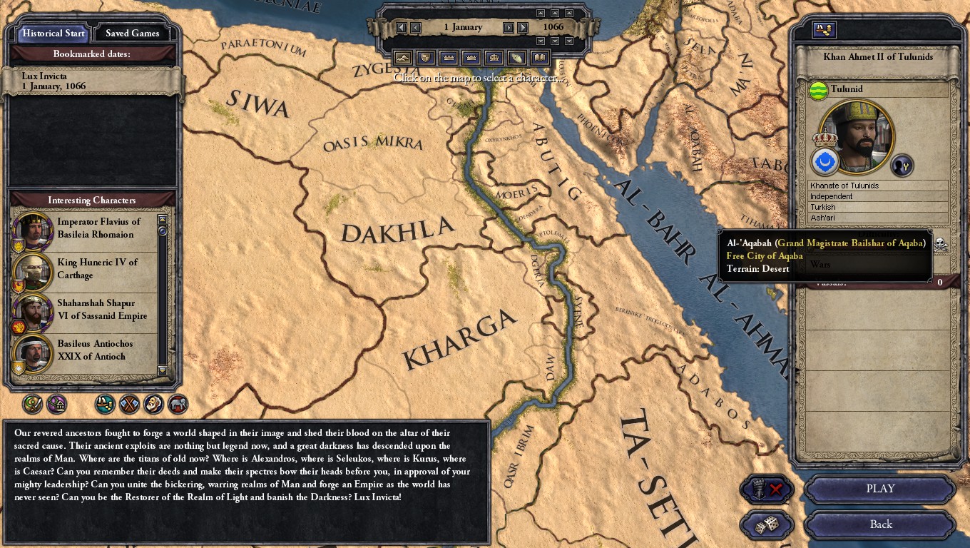
Here's a preview of what I've currently got for Arabia:

2020_11_11_1.png

2020_11_11_2.png

(Don't worry, I've since edited the default.map file to prevent the entire Rub' al-Khali from showing up as part of Yemen lol)

2020_11_11_3.png

2020_11_11_4.png

2020_11_11_5.png

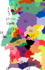
And a look at the barony setup I currently have:
Arabia baronies.png


Obviously this is still incomplete, but it'll do for now. It's hard to find stuff for this area -- I've had to scrounge bits and pieces from various articles that are mainly not about geography. This one has been especially useful. Unfortunately the best potential resource I could find, Gazetteer of Historical North-West Yemen in the Islamic Period to 1650, is sadly confined to Google Books snippet view. If anyone knows of a way I can get access to it, I would be very grateful. And once again, I would like to thank @Gwyn ap Nud for providing resources for this area.

As usual, please let me know if you have any questions or if I messed anything up!
 
  • 7Like
  • 2
  • 1
Reactions:
Impressive reasearch there. The snaky provinces look jarring, though. Maybe you could give them a more organic look? Either my making them "splashes" showing that they're oasis?
 
  • 1Like
  • 1
Reactions:
  • 1Like
Reactions:
Looking great!
I would add some more adjacencies. In order of importance:
al-Hasa-to-Yamama. The Qarmatians were an important power that controlled al-Yamama from their base in al-Hasa, so you should be able to exert direct control across that stretch of the desert.
Aqiq-to-Jurash. Though a more minor route across the desert, there was a lot of travel that skirted the northern edge of the Empty Quarter. This will also help outline the Empty Quarter a bit better.
Jubba/al-Hail/Fayd-to-al-Jawf. A more minor one, but I'm of the belief that a more inter-connected Arabia will play better. And there was direct trade between these locations.
Al-Thalabiyya-to-Basra. Obviously not a direct adjacency, but there was a line of wells (Lina, as-Salman, al-Akhadid, etc) allowing travel across the desert, avoiding al-Batina. So you would your Mecca-an-Nibaj-Hafar-Basra line, your Medina-al-Thalabiyya-Lina-Basra line, and your Medina-al-Thalabiyya-Zubala-Najaf line.

As for how to visually show the lines of wells, it depends what you want to emphasize. Thin provinces emphasize that these are narrow lines of passage across the desert. Dotted oases with manually inputted adjacencies get across the desertedness, but make adjacency less obvious and I believe underemphasizes how populated and powerful the desert tribes really were. Lastly, thicker linear provinces de-emphasize that these were narrow lines of passage, instead focusing on the power of the Bedouin tribes.

Also I would rename some counties to emphasize other provinces.
An-Nibaj for example is less important than al-Qaryatan. Ha'il or Fayd are both good names for the province that contains them and Jubba.
Lastly, al-Hasa looks like 2-3 baronies in a small oasis, I think it would be better to show it as 3-4 baronies (al-Hasa, al-Hajar, Juatha, al-Rumailah at least) controlling more land around it, but have the actual city models be clustered around the oasis.
 
  • 4Like
  • 2
Reactions:
@Trinculo , https://www.abebooks.co.uk/97834870...rical-North-West-Yemen-Islamic-348709195X/plp seems relatively cheap.

I couldn't find it for free online, sadly. But this seems cheaper than the $700 USD on Amazon :)

Sadly, I did not notice it was in German :(
Yeah, I'd seen that. It caught my eye because the price was cheap... but then the shipping was over twice as much lol. Still, the total is under $50 which isn't too bad so I'll just have to save up for it. In any case, thanks for looking!

Looking great!
I would add some more adjacencies. In order of importance:
al-Hasa-to-Yamama. The Qarmatians were an important power that controlled al-Yamama from their base in al-Hasa, so you should be able to exert direct control across that stretch of the desert.
Aqiq-to-Jurash. Though a more minor route across the desert, there was a lot of travel that skirted the northern edge of the Empty Quarter. This will also help outline the Empty Quarter a bit better.
Jubba/al-Hail/Fayd-to-al-Jawf. A more minor one, but I'm of the belief that a more inter-connected Arabia will play better. And there was direct trade between these locations.
Al-Thalabiyya-to-Basra. Obviously not a direct adjacency, but there was a line of wells (Lina, as-Salman, al-Akhadid, etc) allowing travel across the desert, avoiding al-Batina. So you would your Mecca-an-Nibaj-Hafar-Basra line, your Medina-al-Thalabiyya-Lina-Basra line, and your Medina-al-Thalabiyya-Zubala-Najaf line.
Yeah, I'd wanted to have a lot more adjacencies than I have now, but I couldn't really find any holdings to put there. I'll at least add in manual adjacencies to fix this, and I'll look into potential holdings in the future. There was also apparently a route from Qaraqir in the Wadi Sirhan area over to Najaf, which I've been able to find holdings for, and a route from Fayd to Tayma' which I haven't.

As for the shape of the provinces themselves, I plan on keeping the current narrow shapes. I tried playing around with this, but I found that the thicker provinces (the western corridor from the Wadi Sirhan down to Khaybar being an example that stuck around due to laziness) just looked ugly and artificial, while also kind of obscuring the underlying trade routes they were supposed to represent. I realize that it's mostly just a matter of personal preference, but I did put some thought into this and the current design is intentional lol.
 
(Still no Portugal though.)
I hope this means Portugal is getting thoroughly researched in order to do that place some justice and give it the detail it deserves.
For too long in CK History it has been the neglected backwater of Hispania (which has always been neglected as whole in comparison to the rest of Western Europe) when it comes to province density and detail, seriously, Northern Portugal in Particular has always been particularly dense for Hispanian standards, in fact it is estimated to have the same density as the average in the Kingdom of France. Not only was it dense, but it was also completely fragmented and dominated by the petty nobility, so much so that its first King moved the Capital further South to centralise his desmenese.
And yet, despite this deep density and complexity, all CK games (and EU too) insist in merging this in a single large "Porto" province. In ck2 in particular you could fit 7(!) Welsh counties in that same area.

Not to mention that Hispania as whole needs considerable density in order to properly portray the gradual and slow progress of the Reconquista, because in vanilla its often fully unified in a couple of wars.
 
  • 2Like
  • 1
Reactions:
I recommend making the borders of those desert regions 'vague'. They seems way too artificial and smooth... though, understandable due to no landmarks there.
 
  • 1Like
Reactions:
I recommend making the borders of those desert regions 'vague'. They seems way too artificial and smooth... though, understandable due to no landmarks there.
Do you mean just making them a bit more fractal edges, a bit more "natural" looking rather than straight lines? That could look good, aye.
 
Do you mean just making them a bit more fractal edges, a bit more "natural" looking rather than straight lines? That could look good, aye.

This is what I did for my Arabian rework:

6T5O5p5.png


Granted, later on I toned down some of these oasis /they were too fabulous/ but they looked good ingame.

This was my Egypt also (larger provinces for the oasis, little ones for the dense nome)
F7A17B0480EADAEEC93A6154085F59DE23DE2969
 
  • 7Like
  • 3
Reactions:
I recommend making the borders of those desert regions 'vague'. They seems way too artificial and smooth... though, understandable due to no landmarks there.
Do you mean just making them a bit more fractal edges, a bit more "natural" looking rather than straight lines? That could look good, aye.
Yeah I've tried drawing wavier borders in the past -- you can see some of them in the above screenshots in Byzantium, non-Nile Egypt, parts of Iraq, etc -- so I can definitely redraw them in Arabia. Which areas are the worst offenders? I assume the Yamama, Bahrayn, and al-Jawf regions are among them, but are there any others that stick out?

This is what I did for my Arabian rework:

6T5O5p5.png


Granted, later on I toned down some of these oasis /they were too fabulous/ but they looked good ingame.

This was my Egypt also (larger provinces for the oasis, little ones for the dense nome)
F7A17B0480EADAEEC93A6154085F59DE23DE2969
That looks absolutely gorgeous! I hope my provinces look half as good as yours lol.
 
  • 2Like
  • 2
Reactions:
I hope this means Portugal is getting thoroughly researched in order to do that place some justice and give it the detail it deserves.
For too long in CK History it has been the neglected backwater of Hispania (which has always been neglected as whole in comparison to the rest of Western Europe) when it comes to province density and detail, seriously, Northern Portugal in Particular has always been particularly dense for Hispanian standards, in fact it is estimated to have the same density as the average in the Kingdom of France. Not only was it dense, but it was also completely fragmented and dominated by the petty nobility, so much so that its first King moved the Capital further South to centralise his desmenese.
And yet, despite this deep density and complexity, all CK games (and EU too) insist in merging this in a single large "Porto" province. In ck2 in particular you could fit 7(!) Welsh counties in that same area.

Not to mention that Hispania as whole needs considerable density in order to properly portray the gradual and slow progress of the Reconquista, because in vanilla its often fully unified in a couple of wars.
Yeah, I've tried tackling Portugal but I couldn't get very far. I couldn't find any maps to use as resources, apart from ones showing the general evolution of Portugal's borders during the period, as well as one showing military orders' holdings. They're good to have, of course, but they only go so far. Other than that, I had to just draw borders based on present-day municipalities. I ended up deciding to wait and do Portugal later, once I've finished converting what I had in CK2.

I can show what I had of Portugal in case you're interested:
Portugal rough.png


  1. Viana da Foz do Lima
  2. Braga
  3. Barcelos
  4. Maia
  5. Porto
  6. Guimarães
  7. Sousa
  8. Baião/Riba Douro
  9. Vila Real
  10. Coimbra
  11. Cantanhede
  12. Viseu
  13. Lisboa
  14. Ourém
  15. Tomar
  16. Crato
  17. Portalegre
  18. Óbidos
  19. ??? (possibly Abrantes)
  20. Aviz
  21. Arraiolos
  22. Alcácer do Sal
  23. ???
  24. Odemira
  25. Silves
  26. Beja
  27. Serpa
  28. Mértola
  29. Faro
  30. ??? (possibly Monsanto or Castelo Branco)
  31. Braganza

There are a few provinces in there that I didn't properly define and I've since forgotten what they were supposed to represent. There are a bunch of provinces clustered around Porto and the Galician border. And of course you could probably add lots of other counties as well.
 

Attachments

  • Portugal rough.png
    Portugal rough.png
    10,2 KB · Views: 0
  • 2
Reactions:
Yeah, I've tried tackling Portugal but I couldn't get very far. I couldn't find any maps to use as resources, apart from ones showing the general evolution of Portugal's borders during the period, as well as one showing military orders' holdings. They're good to have, of course, but they only go so far. Other than that, I had to just draw borders based on present-day municipalities. I ended up deciding to wait and do Portugal later, once I've finished converting what I had in CK2.

I can show what I had of Portugal in case you're interested:
View attachment 652775

  1. Viana da Foz do Lima
  2. Braga
  3. Barcelos
  4. Maia
  5. Porto
  6. Guimarães
  7. Sousa
  8. Baião/Riba Douro
  9. Vila Real
  10. Coimbra
  11. Cantanhede
  12. Viseu
  13. Lisboa
  14. Ourém
  15. Tomar
  16. Crato
  17. Portalegre
  18. Óbidos
  19. ??? (possibly Abrantes)
  20. Aviz
  21. Arraiolos
  22. Alcácer do Sal
  23. ???
  24. Odemira
  25. Silves
  26. Beja
  27. Serpa
  28. Mértola
  29. Faro
  30. ??? (possibly Monsanto or Castelo Branco)
  31. Braganza

There are a few provinces in there that I didn't properly define and I've since forgotten what they were supposed to represent. There are a bunch of provinces clustered around Porto and the Galician border. And of course you could probably add lots of other counties as well.

Research on Portugal and much of Spain is a pain because of the lack of well defined Carolingian borders, pre-existing political entities of note, or just a lack of clear feudal boundaries.

I got much of my Spanish research from academic papers (noble family possessions and the like). They tend to be accurate, of course, but not very visual. It's very time consuming.

I'll eventually tackle Portugal myself, if I get somewhere with my research (after exam season, probably xD) I'll share what I learn.
 
  • 1
Reactions:
Yeah I've tried drawing wavier borders in the past -- you can see some of them in the above screenshots in Byzantium, non-Nile Egypt, parts of Iraq, etc -- so I can definitely redraw them in Arabia. Which areas are the worst offenders? I assume the Yamama, Bahrayn, and al-Jawf regions are among them, but are there any others that stick out?


That looks absolutely gorgeous! I hope my provinces look half as good as yours lol.
Cèsar de Quart has the right idea. I recommend following his philosophy for desert regions into the future.
 
  • 1Like
  • 1
Reactions:
Yeah, I've tried tackling Portugal but I couldn't get very far. I couldn't find any maps to use as resources, apart from ones showing the general evolution of Portugal's borders during the period, as well as one showing military orders' holdings. They're good to have, of course, but they only go so far. Other than that, I had to just draw borders based on present-day municipalities. I ended up deciding to wait and do Portugal later, once I've finished converting what I had in CK2.

I can show what I had of Portugal in case you're interested:
View attachment 652775

  1. Viana da Foz do Lima
  2. Braga
  3. Barcelos
  4. Maia
  5. Porto
  6. Guimarães
  7. Sousa
  8. Baião/Riba Douro
  9. Vila Real
  10. Coimbra
  11. Cantanhede
  12. Viseu
  13. Lisboa
  14. Ourém
  15. Tomar
  16. Crato
  17. Portalegre
  18. Óbidos
  19. ??? (possibly Abrantes)
  20. Aviz
  21. Arraiolos
  22. Alcácer do Sal
  23. ???
  24. Odemira
  25. Silves
  26. Beja
  27. Serpa
  28. Mértola
  29. Faro
  30. ??? (possibly Monsanto or Castelo Branco)
  31. Braganza

There are a few provinces in there that I didn't properly define and I've since forgotten what they were supposed to represent. There are a bunch of provinces clustered around Porto and the Galician border. And of course you could probably add lots of other counties as well.
It's indeed really hard to find any proper easily digestible information on the Portuguese middle ages, i have some information on the population distribution and judicial districts (Could represent the Duchies) but all the information i'm going to provide to you in the inserted files is from the 14th-16th centuries, so take it with the grain of salt (Most notably, the great depopulation of the south, which wouldn't be the case before the reconquista and the expulsions, and the absolutely massive size of Lisbon, which did not become capital untill 1256 and experienced a massive boost during the early discoveries).
Looking at the provinces you have right now, i'm going to suggest a couple of tens of relevant additions, expecially on the sparser areas (which i assume are still WIP).

Valença 1' [was an actual county, of significant frontier importance, it was actually called Contrasta, meaning opposite (of Tui) untill the 13th century]

Chaves 2' (Important to be a county because it switched hands between Portugal and León multiple times in the 10th-12th centuries)

Miranda 3' (Important to be a county because it switched hands between Portugal and Castile multiple times in the 13th-14th centuries)

Mogadouro 4' (Fortified town of significant importance for the early holy orders)

Santa Maria da Feira 5' (It was an actual county)

Aveiro 6' (it was a "donatary", of significant economic relevancy)

Lamego/Tarouca 7' (Lamego was a much bigger and more important city, but Tarouca was an actual county)

Guarda/Marialva 8' (Guarda was a much bigger and more important city, but Marialva was an actual county)

Covilhã 9' (An important cultural centre where in 1189 was written the first text in the new Portuguese Language, begining the separation from Galician)

Trancoso 10' (A very relevant medieval city, home to several battles and sieges)

Leiria 11' (Important to be a county because it was conquered individually in 1135)

Santarém 12' (Important due to sheer significance of the city)

Almada 13' (Important donatary of the Order of Santiago)

Tavira 14' (Sheer size and importance of the city)

Lagos 15' (Since the Algarve should be at least a duchy, it should get a significant number provinces, Lagos is a fundamental one)

Alcobaça 16' (Relatively Important city)

Ourém 17' (It was an actual county)

Arganil 18' (It was an actual county)

Pinhel 19' (Was an important Bishophoric)

Melgaço 20' (A land of significant occupation during Celtic, Roman and Suevian eras, and an important frontier province from the Medieval period onwards)

23: ???
??? would probably be Ourique

Portugal rough.png

A visual representation of their locations.

If you need further visual help, I can also suggest this map (although it's from the 16th century)
gI8rHYT.gif

Also, i would suggest a higher barony count in the North (To better portray the highly complex terrain and climate differences, with rugged mountains next to plateus and valleys, big temperature differences in a very short distance, and densely forested areas next to barren ones) compared to the south (mostly flat grasslands and warm all around) but on the flip side the South should have a higher number of counties and duchies, because due to the Reconquista, that's where most border changes and political shenanigans would happen. And ideally , expansion should be slow and steady.

Glad to be of any more help.
 

Attachments

  • Portugal Titles.png
    Portugal Titles.png
    319,4 KB · Views: 0
  • Portugal Population.png
    Portugal Population.png
    616,2 KB · Views: 0
Last edited:
  • 2Like
  • 2
  • 1
Reactions:
It's indeed really hard to find any proper easily digestible information on the Portuguese middle ages, i have some information on the population distribution and judicial districts (Could represent the Duchies) but all the information i'm going to provide to you in the inserted files is from the 14th-16th centuries, so take it with the grain of salt (Most notably, the great depopulation of the south, which wouldn't be the case before the reconquista and the expulsions, and the absolutely massive size of Lisbon, which did not become capital untill 1256 and experienced a massive boost during the early discoveries).
Looking at the provinces you have right now, i'm going to suggest a couple of tens of relevant additions, expecially on the sparser areas (which i assume are still WIP).

Valença 1' [was an actual county, of significant frontier importance, it was actually called Contrasta, meaning opposite (of Tui) untill the 13th century]

Chaves 2' (Important to be a county because it switched hands between Portugal and León multiple times in the 10th-12th centuries)

Miranda 3' (Important to be a county because it switched hands between Portugal and Castile multiple times in the 13th-14th centuries)

Mogadouro 4' (Fortified town of significant importance for the early holy orders)

Santa Maria da Feira 5' (It was an actual county)

Aveiro 6' (it was a "donatary", of significant economic relevancy)

Lamego/Tarouca 7' (Lamego was a much bigger and more important city, but Tarouca was an actual county)

Guarda/Marialva 8' (Guarda was a much bigger and more important city, but Marialva was an actual county)

Covilhã 9' (An important cultural centre where in 1189 was written the first text in the new Portuguese Language, begining the separation from Galician)

Trancoso 10' (A very relevant medieval city, home to several battles and sieges)

Leiria 11' (Important to be a county because it was conquered individually in 1135)

Santarém 12' (Important due to sheer significance of the city)

Almada 13' (Important donatary of the Order of Santiago)

Tavira 14' (Sheer size and importance of the city)

Lagos 15' (Since the Algarve should be at least a duchy, it should get a significant number provinces, Lagos is a fundamental one)

Alcobaça 16' (Relatively Important city)

Ourém 17' (It was an actual county)

Arganil 18' (It was an actual county)

Pinhel 19' (Was an important Bishophoric)

Melgaço 20' (A land of significant occupation during Celtic, Roman and Suevian eras, and an important frontier province from the Medieval period onwards)

23: ???
??? would probably be Ourique

View attachment 653310
A visual representation of their locations.

If you need further visual help, I can also suggest this map (although it's from the 16th century)
View attachment 653278

Also, i would suggest a higher barony count in the North (To better portray the highly complex terrain and climate differences, with rugged mountains next to plateus and valleys, big temperature differences in a very short distance, and densely forested areas next to barren ones) compared to the south (mostly flat grasslands and warm all around) but on the flip side the South should have a higher number of counties and duchies, because due to the Reconquista, that's where most border changes and political shenanigans would happen. And ideally , expansion should be slow and steady.

Glad to be of any more help.
Oh wow, thank you so much! This will help a lot with finishing Portugal a lot earlier than I expected.

Also, I started redrawing some of Arabia's desert provinces per the discussion above. How does this look?
NW Arabia WIP.png
 
  • 5Like
  • 3
Reactions:
I tried to see how my attempt at desert provinces looks and I have to say, in the immortal words of George Lucas, I may have gone too far in a few places...

c8sBVfW.jpg

But overall, I'm happy with how organic they look.

1PbxbiP.jpg

Especially this string of desert oasis:

m39MUed.jpg

The "spots" are just a test, no reason for them to be there at all, but I like how they look.
 
  • 2Like
  • 2Love
Reactions:
The blobs are a good way to hide the snakiness of the connection between certain provinces. Although it looks kinda weird when the blobs are too far away from the "main" province.
 
  • 2
Reactions:
I haven't added any additional baronies to Arabia, but here are the redrawn borders I've done so far:
Arabia revisited.png

I wasn't sure where the connections were historically between al-Yamama and al-Hasa so they're currently kind of arbitrary, but at least they exist now lol. I would also like to add the connection between ath-Tha'labiyyah and Basra as mentioned above, as well as a string of baronies connecting an-Najaf with Wadi Sirhan in the north, but I'm not sure if I want to add more counties to such a sparsely populated area.

The bulk of my recent efforts, though, have been directed towards Persia. It currently has about 270 baronies, in 87 counties:
Persia.png

I want to add even more baronies, especially in Khuzestan and Azerbaijan, but I've had a hard time finding them. The problem with Khuzestan is that, while there are lots of medieval settlements mentioned, I can't determine their exact location. (I've been extremely conservative about adding baronies with unknown locations and have only added a handful of them.) With Azerbaijan, I can't find many settlements mentioned at all. If anyone knows any good sources regarding this, then please do send them my way!
 
  • 6Like
  • 2
Reactions:
I've updated the regular download so it now includes Egypt, Arabia, and Persia in case anyone wants to check that out firsthand. The large-size map, though, is unchanged and doesn't contain these areas.

I've started work on Makran, based heavily off of this article, but I'm concerned that it might not be entirely appropriate for the CK3 period. I want to represent the Baloch tribal areas in at least some detail, but in the process a lot of baronies are ending up just being river valleys, mountain areas, or settlements that may not have existed until more the EU4 time period. I also kind of want to add the Brahui culture for the more eastern parts of the region. I currently have counties of Jabal Kufs, Tis, Bampur, Sarhadd, Kech, Panjgur, and Armabil, as well as possibly a county of Rask or Mand to take some baronies away from Tis and Kech which would otherwise have like 10 lol.
 
  • 1Like
  • 1
Reactions: