• We have updated our Community Code of Conduct. Please read through the new rules for the forum that are an integral part of Paradox Interactive’s User Agreement.

Pavía

Content Design Lead PDX Tinto
Paradox Staff
12 Badges
Jan 3, 2006
3.835
160.662
  • Crusader Kings II
  • Europa Universalis III Complete
  • Europa Universalis IV
  • Heir to the Throne
  • Europa Universalis III Complete
  • Europa Universalis III Complete
  • 500k Club
  • Europa Universalis IV: El Dorado
  • Europa Universalis IV: Cradle of Civilization
  • Crusader Kings II: Jade Dragon
  • Stellaris: Distant Stars
  • Stellaris: Ancient Relics
After discussing it with @Johan , we thought it would be a good idea to show you some of the relevant changes we applied to the game after your feedback in Tinto Maps #1. In the form of more maps, of course.

We standardized the Province names, and made some other changes that you suggested:
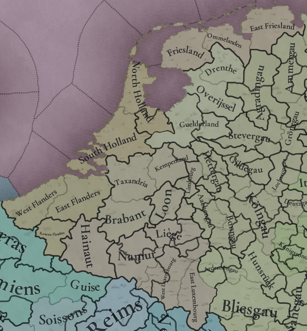
Reworked Provinces.jpg


The vegetation of the region has also been adjusted:
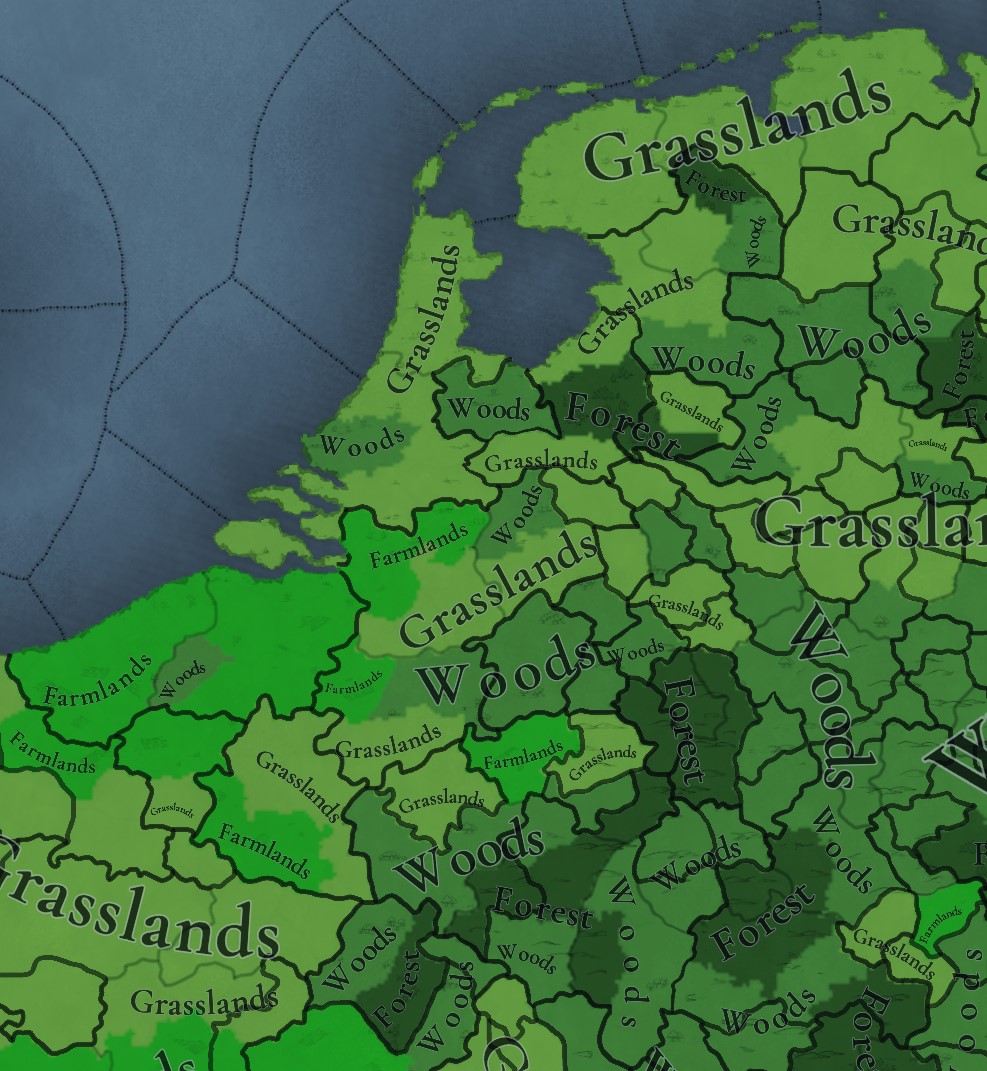
Reworked Vegetation.jpg


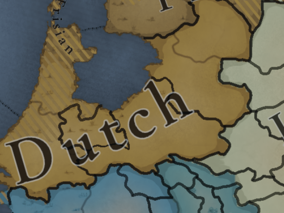
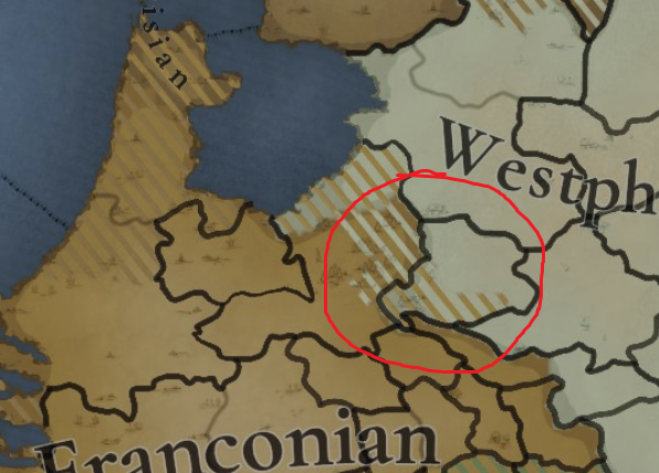
Cultures - there is an important rework here, as we unified the Dutch and Flemish cultures into 'Lower Franconian', one of the possible suggestions you made; the Franconian cultures in the Rhineland are also more consistent among them (although we won't be talking in detail about the cultures of Germany until the Tinto Maps devoted to the region):
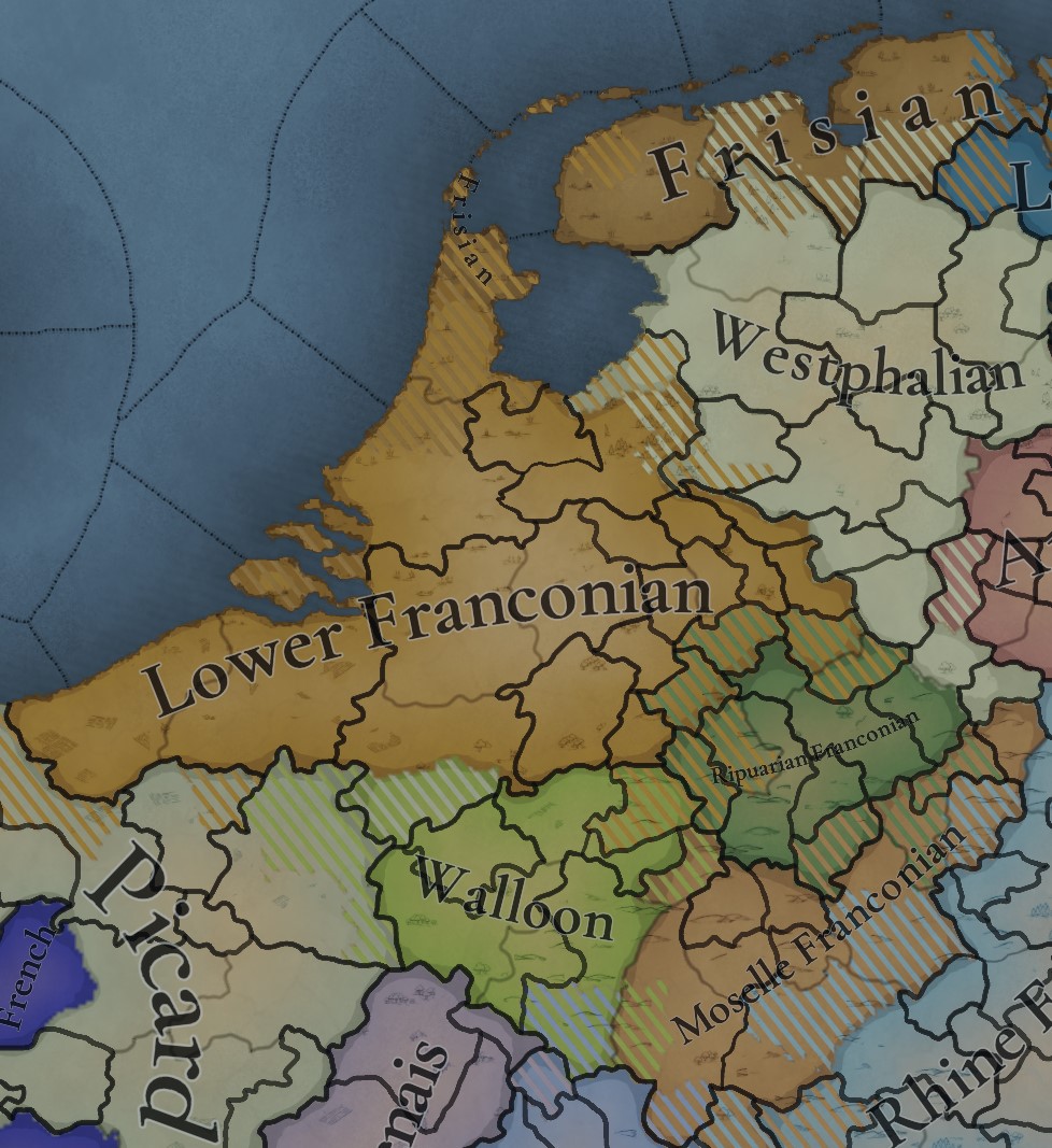
Reworked Cultures.jpg


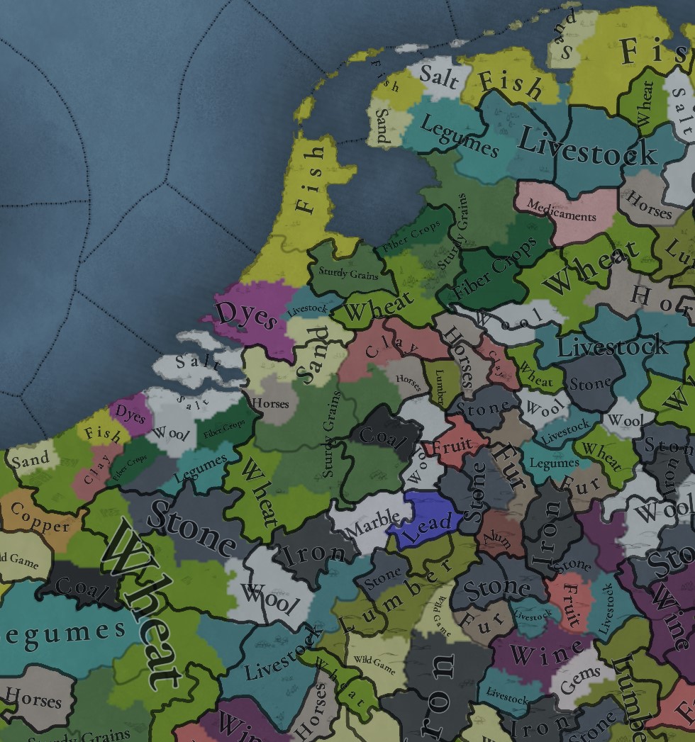
Finally, the Goods rework:

Reworked Goods.jpg


These are part of the tweaks that I mentioned yesterday that we've done, as there are more. Apart from the setup changes, the location map rework will take a bit more time; but we wanted to show you a sneak peek of how we're doing with your feedback. Cheers!
 
  • 103Like
  • 49Love
  • 6
  • 2Haha
  • 2
Reactions:
Very nice, I only have one thing that stood out to me:
The vegetation of the region has also been adjusted:
Why did you add all these woods and forests to the Netherlands? We discussed this in the thread, and the consensus opinion was that all modern forests in the Netherlands are man-made and weren't present during the game's time period.


The goods look great! Although I still think that Liège as the biggest producer of coal at the start of the game should have that resource and marble moved to a neighboring location. :p
 
Last edited:
  • 24Like
  • 10
  • 1
Reactions:
Very nice changes!

The culture one is especially good, seeing Lower Franconian crossing over into northern Rhineland while Westphalian covers Overijsel is great, much better representation of Dutch cultures than we've had before. Let's hope Dutch and Flemish are emergent cultures that can raise with time. Lower Franconian still being present in Artois is also great.

Looking forward to seeing how the locations change and what gets added as well!
 
  • 37Like
  • 2
Reactions:
Looks good!

I just got around to posting a response to the earlier thread from my Meiou and Taxes research. It doesn't have much specificity, so maybe isn't quite as useful as locals who can provide exact recommendations, but it might be worth a look. At a glance, Frisia should have horses somewhere, I think.

Fishing is taking up places that should probably be livestock. I echo the suggestion of another person to move fishing offshore and represent it with an urban building, then you could have livestock in Holland and Frisia. Fishing was a major industry, but so was butter/cheese production in the same areas. To represent both, I think you need to move fishing offshore.

All that said, the main thing that I pointed out in that post was peat harvesting. This was a major industry. It was an important source of cheap energy and encouraged investment (for drainage projects)/interest in boggy regions. I think it needs to be represented in some way.
 
Last edited:
  • 9Like
  • 4
  • 1Love
  • 1
Reactions:
Looking at the trade goods, I'd change the raw good for Nijmegen (and/or Tiel if added) to Fruit.

Betuwe is famous for its fruit (particularly apples), it produces a third of all fruit grown in the Netherlands today!
 
  • 2Like
Reactions:
Looking at the trade goods, I'd change the raw good for Nijmegen (and/or Tiel if added) to Fruit.

Betuwe is famous for its fruit (particularly apples), it produces a third of all fruit grown in the Netherlands today!
Agreed, I wasn't sure if fruit were supposed to be this far north when I suggested goods, since they're often meant to be exotic fruit like citrus or bananas, but I guess there's no reason not to represent fruit like apples and cherries.
 
My comparison memory isn’t that great. Can someone summarize the province and good changes? That labeled good change map seems like it was followed?
Yeah it's close to my suggestions, with some other input added, like what @SulphurAeron posted (which makes perfect sense).
 
  • 3Like
Reactions:
Really love representing the culture as 'Low-Franconian', it's always bugged me a bit that it got called 'Dutch' in older games.

I notice though that the coastline remains unchanged, will you be changing this later (or is this perhaps what you meant by location map?)?
 
  • 4
  • 2Like
  • 2
Reactions:
A commendable initiative!

Would you be open to reconsider the rye-wheat distinction, or is it set in stone by now?

If so, the Northern German wheat provinces should at least grow sturdy grains (as should most Central and Southern German ones) - see attached map (It's from 1900, so growing patterns during the little ice age would be more beneficial towards rye, if anything).

Legend: light orange: predominantly rye and oats, yellow: mixed, light green: predominantely wheat and barley
landwirtschaft-deutsches-reich-karte-lithographie-1899-original-der-zeit-3868723781(1).jpg

(Also Angrian, very cool!)
 
  • 4Like
  • 1
Reactions:
Would you be open to reconsider the rye-wheat distinction, or is it set in stone by now?
Not sure what you mean? This is just for the Low Countries, Germany wasn't worked on.
I suggested the rye-wheat distribution in the Low Countries based on data from around the time the map you posted was made - which is probably the best we have.
I'm also working on my suggestions for Germany which will also use these German Empire maps for rye-wheat distribution.

One thing to note regarding this map is that it was made in a time where potatoes were fully established, so that will skew the numbers a bit. Also it doesn't take into account livestock which were very important in certain regions marked as rye dominant (like the very South and North).
 
  • 1Like
Reactions:
Not sure what you mean? This is just for the Low Countries, Germany wasn't worked on.
I suggested the rye-wheat distribution in the Low Countries based on data from around the time the map you posted was made - which is probably the best we have.
I'm also working on my suggestions for Germany which will also use these German Empire maps for rye-wheat distribution.

One thing to note regarding this map is that it was made in a time where potatoes were fully established, so that will skew the numbers a bit. Also it doesn't take into account livestock which were very important in certain regions marked as rye dominant (like the very South and North).
I'd prefer rye to be grouped with wheat instead of millet, that's what my first sentence refered to.

Regarding the second part, I thought it natural to change all rye producing locations at the same time, but yes, the feedback doesn't make too much sense if they just implemented it based on your suggestion (which I did not know of until you mentioned it).

I only used the map to show where rye was predominant compared to wheat, for which it is adequate.
 
If changes are already being implemented, can I suggest that Frisian Freedom sees some radical reworks due to how a single tag doesn't do its history justice, as per this thread @Pavia please.
This is at least the second time I've seen someone say having a single Frisian Freedom tag is historically inaccurate, but fail to provide a good alternative. The linked twitter thread, almost as a throwaway, suggests it be nominally part of holland but with total peasant autonomy. Issues is, Project Caesar does not have an autonomy system. It has a control system. An area with extensive internal autonomy would be a separate tag anyway. Well, you could have them be part of Holland with zero control, but then you'd need a unique and arbitrary modifier for why they can't enforce their authority in their own back yard.
 
  • 29
  • 7Like
  • 2
  • 1
Reactions:
I'd prefer rye to be grouped with wheat instead of millet, that's what my first sentence refered to.

Regarding the second part, I thought it natural to change all rye producing locations at the same time, but yes, the feedback doesn't make too much sense if they just implemented it based on your suggestion (which I did not know of until you mentioned it).

I only used the map to show where rye was predominant compared to wheat, for which it is adequate.
I don't understand, you want rye to be represented by the wheat good? But the whole point of having a sturdy grain good is to have something like rye, which is grown in colder regions, be separate from wheat. And if it's grouped with wheat, then that map doesn't have any use.

The Map feedback threads move from region to region, this one is for the Low Countries only. So we will have to wait for the German one to suggest grain distribution there.
 
  • 1
  • 1Like
Reactions: