• We have updated our Community Code of Conduct. Please read through the new rules for the forum that are an integral part of Paradox Interactive’s User Agreement.
I believe a more detailed representation of Polish and Pomeranian Slavs would be appropriate. Specifically, I suggest designating Pomeranian as a distinct language, with Kashubian and Slovincian as dialects under that umbrella.

It also seems that the descendants of the Slavic Pomeranian tribes are currently grouped entirely under the Kashubian culture. However, the Kashubians are not the sole descendants of these tribes. Other groups, such as the Slovincians, Raniers, Uzedoms, Borowiacy, and Kociewiacy, also trace their origins to the Pomeranian tribes. Each of these groups had their own languages or dialects, as well as distinct cultural identities, and historically inhabited the broader Pomeranian region.

What I’m trying to emphasize is that not all Slavic Pomeranians were Kashubians, and it would be great to see this diversity reflected in the game.

I would greatly appreciate input from someone more knowledgeable on this topic!
 
  • 2Like
  • 1
Reactions:
Not sure if anyone has suggested this yet, but wouldn't the most natural area division for the Livonian order be to just divide it like how it was often divided historically: into Estonia, Livonia and Courland? I think it would be historically more immersive than a division into Estonia and Latvia, like some have suggested.
1735670638190.png


1735670785977.png

1735670806479.png
1735670841827.png
 
  • 11
  • 7Like
  • 1Love
  • 1
Reactions:
I have a minor and easily implementable suggestion.
Please rename the Livonian Order's location Jēkabpils to Krustpils/Kreutzburg in Latvian and German respectively. IRL the town of Jēkabpils wasn't founded until 1670 on the other coast of the river Daugava which falls within the in-game location of Selburg. Whereas Krustpils/Kreutzburg is a 13th century castle built by the archbishop within the in-game area of Jēkabpils which also served as a midway point for travel to/from Latgalia
 
  • 5Like
Reactions:
As long as I had some time for a deeper research, I made an update to my feedback on Severia.
Also as long as this region always appears divided on the edges of the three TMs (Ruthenian, The Steppes, Russian), I will post this update in all three threads, sorry.
I will post here only the updated parts from the post.

____________________

DEVELOPMENT & POPULATION
  • It was probably adjusted just by the climate/vegetation, probably development and population should be higher around the duchies' capital locations (Chernihiv, Novhorod-Siversky, they have the lowest development in their duchies for some reason).
  • Also Putyvl and Ovruch vere quite important centres of the Kyivan land in the first half of the XIV century according to 'Ukraine under the Tatars and Lithuania' (Rusyna O.V.,1998), (pages 32, 33 and 35) and should have higher development and population compared to others:

Putyvl.png

Putyvl1.png

Though, concerning the fate of the princes of Putyvl [after the Mongol invasion], there are at least some sources on them in the Novohorod-Siversky church notes (or 'synodyk', that was called 'a bright ray in the dark times of Kyiv after the Batu invasion'). Synodyk mentiones [Kyivan princes] Ivan (Ioann) of Putyvl, his son Ivan-Volodymyr Ivanovych of Kyiv, Andriy of Ovruch (could be the brother of the latter) and his son Vasyl (that was killed in Putyvl) [those are the princes of the first quarter of the XIV century, around 1290 – 1325, as mentioned in the second screenshot].
Probably after having secured the Kyiv throne, Putyvl princes established a strong connection between Kyiv and their 'fatherland', its traces are then observed for the next 200 years. In the acts of the second half of the XV century it was mentioned that Putyvl taxes went to Kyiv and that all Putyvl governors were Kyivan nobles only.
Then (after the Lithuanian-Moscow peace of 1503) Kyivan elites send petitions to the Polish/Lithuanian king Sigismund I the Old that they were very disappointed with the loss of Putyvl that was 'Kyivan holding with 14 volosti around it...'

Ovruch.png

The fact that Ovruch had its own prince meant that it had become quite an important (maybe the second after Kyiv) administrative centre of the Kyiv land in the XIV century. Probably due to the fact that Kyiv lost control of the South, where the Tatars had direct rule.

So I think that these things should be taken into account, Putyvl and Ovruch should have higher development, population and attention within the Kyiv land.
And Chernihiv, Novhorod-Siversky as the capital towns of their duchies:
Development.png


I also think that Chernihiv and Bryansk should be towns due to their historic and regional importance (instead of Kursk that was completely burnt by the Horde twice during 50 years before the game start date).
If Norway has 6 towns, including Hamar with ~6 thousand population, then I think Chernihiv and Bryansk can be towns too.

COUNTRIES
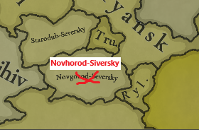
  • Novgorod-Seversky should be Novhorod-Siversky to correspond with the respective location and Ukrainian dialect in the game. Also even though there are no exact data about its ruler, but it should be probably also a random Rurikovych Dynasty guy (probably from the Chernihiv branch), not just a random guy
NS.png
Countries.png
  • Kyiv, Halych, Volhynia, Chernihiv, Novhorod-Siversky (at least these, maybe some other too) should pay tribute to the Golden Horde directly, not via Ivan Kalita. I don't know if it is implemented in the Tatar Yoke IO. but Chernihiv, Kyiv, Kursk other Severian duchies had their ows baskaks from the Horde who collected the tribute to the Horde.

LOCATIONS
  • Please, add Lubech location, or at least rename Ripky to Lubech. Lubech is an ancient town known since the X century, that hosted Council of Lubech (in 1097). Ripky is just a random village first mentioned in 1607:
Lubech.png
Ripky.png
  • I have noticed that Belarusian locations have different transliteration rules, probably should be unified:
Locations_BelTranslit.png


PPROVINCES
The provinces in the region are not perfect:
  • Trubchevsk has a really weird form, while the nearby Kursk is much bigger that the others
  • Putyvl belonging to the Trubchevsk province is not natural at all
  • Novgorod-Seversky is a Russian transliteration, while everything else is Ukrainian (including the respective location)
Provinces_Bad.png

I suggest:
  • Correct the name of Novgorod-Seversky to Novhorod-Siversky or better to Southern Severia to avoid transliteration bias, together with Starodub to Northern Severia, Trubchevsk to Eastern Severia
  • Transfer Putyvl to Southern Severia, where it naturally and historically belongs to (e.g., the prince Igor Svyatoslavovych in 'The Tale of Igor's Campaign' was the prince of Novhorod-Siversky. His wife was waiting for the prince in Putyvl)
  • Transfer Kosozhichi and Fatezh from Kursk to Eastern Severia/Trubchevsk
  • This way all the provinces will have 6-7 locations and the borders look nice and natural:
Locations_Provinces.png
Provinces_Proposed.png


AREAS
Areas need an important rework too:
Areas_Better.png
  • Firstly, Gomel province should belong to Severia. The Dnipro river makes a perfect natural border between the Black Ruthenia and Severia here. Gomel had been a core holding of Chernihiv for senturies and was considered as Severia too. You portraied it perfectly in the cultures map
  • Secondly, Sloboda Ukraine goes way too far to the north and include the lands that has never been Sloboda-Ukraine. This area should be renamed to the Kursk Area.
  • Concerning the Sloboda-Ukraine I made a suggestion in the Steppes TM, this is where it belongs:
Areas.png
Lastly, I liked that Kyiv area was called Ukraine, I don't know why you changed it. East/West Dnipro are probably the worst possible options just because there are more historical or flavourful alternatives:
  • The lands around the Dnipro were never referred to as West/East in chronicles or the people.
  • Those were either the Right/Left Bank or just Kyiv Land/Pereyaslav Land (Київська Земля, Переяславська Земля).
  • It was definitely referred to as Ukraine already by the 1500s because the name Ucrania firsty appeared in the European (French) travel map, in the mid-XVI century. That means the locals started to call this land Ukraine much earlier, quite early within the game time frame.
  • The word Ukraine itself firstly appeared in cronicles of 1189, then 1214 and later on, so there is no problem with calling the area Ukraine, and on the other side Pereyaslav (see the map above)
Ukraine.png
  • That is why I also think that White Ruthenia area can be also called Belarus, as long as this is literally what it means
 
Last edited:
  • 5Like
  • 5Love
  • 2
  • 1
Reactions:
Putyvl belonging to the Trubchevsk province is not natural at all
  • Transfer Putyvl to Southern Severia, where it naturally and historically belongs to (e.g., the prince Igor Svyatoslavovych in 'The Tale of Igor's Campaign' was the prince of Novhorod-Siversky. His wife was waiting for the prince in Putyvl)
  • Transfer Kosozhichi and Fatezh from Kursk to Eastern Severia/Trubchevsk
It seems that in the early 1300s, Rylsk, Dmitriyev, Kosozhichi, Fatezh, and possibly Olgov were ruled from Putyvl - in which case it does make sense to put them together in the same province. I have a post on this somewhere in the Russia feedback thread that I'm too lazy to find.
 
  • 1Like
Reactions:
It seems that in the early 1300s, Rylsk, Dmitriyev, Kosozhichi, Fatezh, and possibly Olgov were ruled from Putyvl - in which case it does make sense to put them together in the same province. I have a post on this somewhere in the Russia feedback thread that I'm too lazy to find.
I have found it with my like :D. Politically yes, interesting information. As long as Putyvl branch of Olgovychi princes ruled in Kyiv in the early 1300s too and Putyvl was kind of integral part of Kyiv land, I think Putyvl must remain in Kyiv. And Rylsk could be a vassal of Kyiv. On the other hand, somewhere else it is written that Lithuania took Rylsk in the late XIII or the beginning of the XIV century, much earlier than other lands.

Nevertheless, the main reason of my proposal was bordergore provinces with extremely curved shapes, with Putyvl belonging to the Novhorod-Siversky province this 'problem' is solved and all provinces look homogeneous.
 
  • 4Like
Reactions:
1. Silesia shouldn't be counted into hre. Treaty of Namysłów 1348 is since when Silesia was an undisputed part of hre.
Till it's 1348 Poland should have real gameplay paths/possibilities to reconquer Silesia which was part of Poland for 400 years by that time.

2. Please fix this abnormality, Duchy of Inowrocław, between Poland and Teutonic Order. You guys mistook Casimir III of Gniewkowo for Casimir III the Great. + from what I remember Duchy fragmented itself in 1314 into 3 duchies. In 1337 only Duchy of Gniewkowo remained, but it was conquered by TO in 1332- its duke fled to Poland. Duchies of Inowrocław and Dobrzyn were exchanged for Sieradz and Łęczyca duchies in central Poland, previously those 2 dukes were in the Kujawy region.
Duchy of Inowrocław shouldn't exist, add location for Gniewkowo and make it a Duchy under Teutonic Order occupation or make TO own it since there shouldn't be an open war between Poland and TO in 1337, conflic was peacefully resolved in 1343 treaty of Kalisz. Either way, add Gniewkowo location.

Casimir of Gniewkowo is III because he is the 3rd Casimir to rule in Kujawy region, while Casimir III the Great is III because he is the 3rd Casimir to rule all Poland.

edit.; PLEASE FIX IT, I made already several, 3-4, comments under Tinto Maps including Poland, about it. I'AM GOING INSANE
edit2. Delete that Norse pagan religion in Sweden. You will remain hypocrites if you don't. Because you didn't include Slavic Pagan religion, Slavic Temple of Arcona fell years after temple in Uppsala which fell in 1080s, while arkona fell in 1168.
 
Last edited:
  • 4
  • 2Like
  • 2
Reactions:
I don't know what sources you guys used for the culture map regarding polatskian, polesian, and auskstatian but it is incredibly messed up, Braslau was made in 1065 on the border with lithuanian tribes in the principality of Polotsk, the name of the city is of slavic origin in all but one theory some of the theories for it's name are that: 1: the most widely accepted theory is that it derives from it's first ruler, brachislav, which is a clearly slavic name. There are other theories that it is accociated with other slavic words such as bras (to gather or to take). There is one theory that states that it is tied to the baltic word "brasla" which translates to the shallow of the river. Even if this one theory is true this city was still irrefutably started in polotsk and and would certainly have not somehow became an Aukštaitijan majority in only 30 years after polotsk became a vassal in 1307. especially as there was only minor migration of lithuanians to ruthenian terrirories and vice versa.


Sources: https://www.jewishgen.org/yizkor/braslaw/bra013.html
https://www.belarus.by/en/travel/to...-beach-festivals_i_0000131136.html?utm_source

Grodno is another city which is wrongly stated to have an Aukštaitijan majority. The city of Grodno was founded in the year 1127 under the kievan rus made on its western border as a trading town. the etymology of the city is seen to be derived from mostly slavic roots. The main theory is that is comes from the slavic word gorodit (meaning to enclose or to fence) the old slavic word "gradŭ" meaning fortress, castle, or town. there is also a standing orthodox church, the Old Grodno Castle, and various other ruthenian archetecture in the area which are one of the last standing examples of archetecture of black ruthenians. It is important to note however that populations in this time often mixed and did not have defnined cultural boundaries and there were a lot of baltic Yotvingians living in the surrounding areas as well so it would be wise to include those as well, however there is no evidence that there was a significant Aukštaitijan population.

Sources: https://en.wikipedia.org/wiki/Kalozha_Church
https://en.wikipedia.org/wiki/Old_Grodno_Castle
https://www.jewishgen.org/belarus/lists/info_history_of_grodno.htm
https://zetgrodno.com/iz-istorii-goroda-grodno

We have established that Both Bralau and Grodno are almost certainly slavic majority cities. Lida is a little bit more grey on this issue. The general consensus is that Lida derives from the lithuanian word lydimas, meaning slash and burn yet this is also close to the slavic term lyada as well as theories of the cities name coming from gothic roots of Lindo, Liht. The city is generally said to have been established in 1323 when its castle was constructed however there is also mention in chronicles that it was built in 1180 under the Dainovsky Principality which was a suboordinate of the Kyivan Rus. Several other towns located inbetween also have mixed origins, Ashmaynty is widely believed to be lithuanian etymologically (deriving its name from the Ašmena river) while the very nearby town of pastavy is generally beleived to be from the slavic word of "postava" translating to figure or character. I should mention that these cities were created after the game peiod ashmyany in 1350 and pastavy 1409 however it still signifies the presence of slavs in the same region.

Sources:
R. Schmittlein. Toponymes finnois et germaniques en Lituanie // Onomastica. Revue Internationale de Toponymie et d'Anthroponymie. — Paris, 1948. — P. 104.


In conclusion I think that the Polesian cultural group should be extended further north ending at grodno, the polastkian cultural group should be in ownership of braslav and likely pastavy, the central area between those two cities would still likely be majority Aukštaitijan (yet not without a significant slavic population) and I think that there should most likely be more lines depicting mixed populations as like it or not the duchy of lithuania was a mixed society and there was no strict border between slavs and balts. I will attach the file of how I think an accurate map would look and some other related maps to the cultural makeup
 

Attachments

  • Kievan_Rus_in_1237_(ru).svg.png
    Kievan_Rus_in_1237_(ru).svg.png
    1,1 MB · Views: 0
  • Полацкая_зямля_ў_ваенна-палітычных_падзеях_XII_ст.svg.png
    Полацкая_зямля_ў_ваенна-палітычных_падзеях_XII_ст.svg.png
    1,9 MB · Views: 0
  • Culture Map Lithuania Redone.PNG
    Culture Map Lithuania Redone.PNG
    1,3 MB · Views: 0
  • 4
  • 3
  • 2
  • 1Like
Reactions:
@Perkunvilkis @Korsjan Rīkis Can you explain how exactly Grodno and Barysaw have completely changed their ethnic composition over the period of 30 years? To my knowledge the settlement of new lands amoung the core population of the peasantry was limited and certainly not enough to change the population in such a short time. These two cities were irrefuteably built under slavic states. The town of braslaw is said to have been built at the border of the lithuanian state and is incredibly likely to come from slavic etymology, feel free to provide a population cencus from 1337 by ethnicity but this is pretty much all we have. Grodno is again stated to have been built on the tribal border of the yotvingians and was definetly under slavic influence untill the 1240s. The name of grodno is almost certain to be etymologically slavic.

I'm free to any ideas you have to share, however I am aware of baseless maps of lithuania shared on wikipedia such as these two:
1736700193470.png
1736700260890.png

Neither of these have any historical evidence as especially in the year 1200 both these cities were actively owned by slavic kingdoms/principalities and were known to have been built on the border of the tribal boundaries therefore making it impossible that they were somehow Aukštaitijan ethnically? The second map is also not based on many real sources but it is from the 16th century so is irrelevent but it is an example of how your idea of the lithuanian ethnicities borders may be different then reality.

Looking at your names and profiles I understand that you are both lithuanian and it is in your interest to make your ethnicity as strong and as powerful as you could possibly make it, however I have been very fair in my assesment of the ethnic borders at the time and I think it is important for EU4 to as most accurately as possible depict its time period. I know that there are technecally no censuses or documents at the time but seeing as both those cities were built in slavic kingdoms / principalities it is very hard to dispute the fact that they are derived of those kingdoms. sadly there are very few maps of this area in this period and even fewer that are legible so we will have to make due and base some of the maps off context etymologically and based off where they have been built.

Feel free to provide any suggestions or input if you think I am wrong or would like to add to this region.
 
  • 4
  • 1Like
  • 1
Reactions:
You are the same person that previously harass and privately message any person that gives your posts a dislike. There is no reason to argue with someone like you since you will never accept any argument againts you. You can read many of them in this or the previous thread.
Some of the cities you mentioned were at a point in time controlled by a slavic state but that's what it was, control. For some reason you are so sure that they eliminated every lithuanian living there while that was the case. If you go by the same logic for this year the ethnic map would look quite different.
You could argue some polatskian minorities in some of those cities because of that previous control. But you can argue for more Lithuanian minorities further east aswell.
 
  • 3Like
  • 1
Reactions:
You are the same person that previously harass and privately message any person that gives your posts a dislike. There is no reason to argue with someone like you since you will never accept any argument againts you. You can read many of them in this or the previous thread.
Some of the cities you mentioned were at a point in time controlled by a slavic state but that's what it was, control. For some reason you are so sure that they eliminated every lithuanian living there while that was the case. If you go by the same logic for this year the ethnic map would look quite different.
You could argue some polatskian minorities in some of those cities because of that previous control. But you can argue for more Lithuanian minorities further east aswell.
You're mixing up the baltic ethnicity with the Aukštaitijan ethnicity, it is a well known fact that the areas of modern Belarus, some of Ukraine and Poland were inhabited by balts untill the slavs came. When the slavs came the balts assimilated into the slavic tribes, this is why we see significant baltic admixture in modern slavic states such as Belarus and Poland. The kyivan rus and polotsk ruled over Braslau and Grodno for over 300 years by which time the balts there almost definitely assimilated as there is no evidence of notable Aukštaitijan minorities. There is evidence for a yotvingian population in the rural areas of grodno which I accounted for.
 
  • 1
Reactions:
I think Racibórz, Jawor, Bolesławiec, and Złotoryja should have farmlands as well. Just basing it on the fact that they are flatlands that had supported relatively large towns for a long time at the start of the game, I could be mistaken of course.
 
Last edited:
  • 2
Reactions:
The mystery of Starogorodkaya location has finally been solved. This is a misspelt street in Oster (an actual ancient settlement that must represent this location).

But the fact that it has already appeared in two feedback map posts of the region, despite being addressed several times before, is quite frustrating :(
(as well as choosing a random new village Ripky instead of the ancient town of Liubech)
Starogor.png
StarogorOster.png
 
Last edited:
  • 8
  • 3
  • 2Like
Reactions:
Hence @Pavía mentioned that they still need to put in order Slavic spelling:
4. Fixing. We have a pending task to unify Slavic spelling, yeah.
I got an idea to help and check transliteration from the Ukrainian language. I believe it should be based on the official standard (accepted by Ukraine and the UN) with a minor adjustment for better flavour.
Link to the standard - Tenth United Nations Conference on the Standardization of Geographical Names.

In fact, most of Ukrainian locations already follow this standard, so good job! Only several corrections will be needed.
I hope it will be also useful for character names, descriptions, flavour terms etc.

Just a brief look at those obvious letters, no need for detail:​
Cyrillic obvious
Latin obvious
A, Б, В, Д, Е,
З, І, И, К, Л,
М, Н, О, П, Р,
С, Т, У, Ф, Х,
Ц, Ч, Ш, Щ
A, B, V, D, E,
Z, I, Y, K, L,
M, N, O, P, R,
S, T, U, F, KH,
TS, CH, SH, SHCH

In the second table everything written in white is official and two minor changes are in yellow.
They are needed to make those names flavourful and relevant instead of too modern 'bureaucratic'. They are actually about avoiding double ii in names such as Maria, Solomia, Natalia, Andriy, Yuriy, Matviy etc.
Cyrillic
Latin
Examples (not always from the game)
ГHУгровеськ - Uhrovesk, Торговиця - Torhovytsia
ҐGҐорґани - Gorgany
ЖZHЖидачів - Zhydachiv
Жовква - Zhovkva
ЗГZGHЗгурівка - Zghurivka
ЙY - at the beginning of a word and after i to avoid modern bureaucratic doubled ii in names
i
- in other cases
Йосип - Yosyp, Андрій - Andriy (not Andrii etc.)
Бойко - Boiko, Стрий - Stryi
Новгород-Сіверський - Novhorod-Siverskyi
ЄYe - at the beginning of a word
ie - in other cases
Єланець - Yelanets
Докучаєв - Dokuchaiev
ЇYi - at the beginning of a word
i - in other cases
Їжак - Yizhak
Ананьїв - Ananiv
ЮYu - at the beginning of a word
iu - in other cases
Юнаківка - Yunakivka
Любар - Liubar
ЯYa - at the beginning of a word
ia - in other cases
a - after i to avoid modern bureaucratic doubled ii in names
Яворів - Yavoriv
Снятин - Sniatyn
Марія - Maria (not Mariia, Nataliia etc.)
ЬNot reproducedСокаль - Sokal
'(apostrophe)Not reproducedМар'їнка - Marinka

According to this, the following locations have wrong/inconsistent spelling (marked with red in the map at the end). I also provide historical Ukrainian names for the locations written in Polish (marked with yellow in the map at the end, but in 1337 they are owned by Halych and Halychian culture):​

Wrong spelling
Correct spelling
UgroveskUhrovesk
TuriiskTuriysk
Mel'nytsyaMelnytsia
PeresopnytsyaPeresopnytsia
Bereschany (it is German spelling)Berezhany
Sbarasch (it is German spelling)Zbarazh
Tykhomel'Tykhomel
ZvyahelZviahel (you have it right at the province map)
DragushovDrahushiv
SherbivShcherbiv (with a Щ, not a Ш)
ZdvizhenZdvyzhen
Zavalye (it is Russian spelling, not Ukrainian)Zavallia
Starogorodkaya (it is a street name in Oster)Oster
Ripky (it is a new village)Liubech (it is a known ancient town)
Melnya (shown in the Russian TM Feedback)Melnia
Polish name
Ukrainian name
PrzemyslPeremyshl
JaroslawYaroslav
RzeszowRiashiv
LubaczowLiubachiv
PiskorowicePyskorovychi
KrasnystawKrasnostav
GrabowiecHrabovets
ChelmKholm


Also some Ukrainian suggestions for dynamic naming for some locations around (the most obvious ones):​

Belarusian/
Russian name
Ukrainian name
Chernyany​
Cherniany​
StolinStolyn
BuinovichiBuinovychi
StodolichiStodolychi
Belaya SorokaBila Soroka
KalinkavichyKalynkovychi
KhoinikiKhoinyky
KholmyechKholmech
TereshkovichyTereshkovychi


Hungarian name
Ukrainian name
Ungvar​
Uzhhorod​
NagybereznaBereznyi
MunkacsMukachevo
BeregszaszBerehove
OkormezoVolove (historical name of Mizhhiria before 1953)
HusztKhust
RahoRakhiv
MaramarosszigetMarmarosh


Romanian name
Ukrainian name
Strasinet​
Storozhynets​
CernautiChernivtsi
Cetatea TetinaTsetsyna,
but once more I emphasise that this place is within Chernivtsi, so I prefer Onut
HotinKhotyn
LipnicLypnyk
SorokaSoroky
BaltiBeltsi

And the respective maps with highlighted locations (red - wrong spelling, yellow - dynamic naming):
UALocs.png


UALocBalk.png


Hope it would be of help!
 
Last edited:
  • 7Like
  • 7Love
  • 2
  • 1
Reactions:
They are actually about avoiding double ii in names such as Maria, Solomia, Natalia, Andriy, Yuriy, Matviy etc.
I’m a fan of turning all ii into iy, including before a vowel. I think a spelling like Mariya is a better explanation for western audiences of how to pronounce it than Maria.
Uzhorod (without double zz)
Uzhhorod or bust. It’s not Ужород after all.
 
  • 3Like
Reactions:
Uzhhorod or bust. It’s not Ужород after all.
Thanks, really after hours of preparing the post I messed it up with Czech/Slovak.

I’m a fan of turning all ii into iy, including before a vowel. I think a spelling like Mariya is a better explanation for western audiences of how to pronounce it than Maria.
I thought these names are so ‘classical’ and universal and the difference is so small, that they can be also used. If even official standard accepts some simplifications with apostrophes and Ь. And the differences is not like John/Ivan.
Btw, I also did a small ‘research’ through my facebook friendlist and noticed that ~2/3 tend to use classical versions -ia and ~1/3 have -iia/-iya.
 
  • 2Like
Reactions:
My suggestions on possible Works of Art and unique buildings (ex-monuments in EU4) around Ruthenian lands.


These I consider as must-have:
KPLavra.jpg
Kyiv-Pechersk Lavra – Kyiv

Unique building – monastery

  • Founded in 1051
  • The most important and influential Orthodox monastery in the East Slavic lands
  • Should provide some Orthodox benefits, literacy, cultural tradition/influence, clergy power
  • Wiki page
Sophia.jpg
St. Sophia Cathedral – Kyiv

Work of Art – cathedral

  • Built between 1017 and 1037, survived the Mongolian invasion
  • The cathedral of Metropolitans of Kyiv
  • The most famous and important Kyivan cathedral
  • Wiki page
CathChernihiv.jpg
Transfiguration Cathedral – Chernihiv

Work of Art – cathedral

  • Built between 1030 and 1036 and survived the Mongolian invasion
  • One of the two oldest still existing Kyivan Rus churches (with St. Sophia in Kyiv)
  • Maybe even the oldest, could be build 1 – 2 years earlier than St. Sophia
  • Wiki page
VolVol.jpg
Dormition Cathedral – Volodymyr-Volynsky (Volhynia)

Work of Art – cathedral

  • Built in 1160
  • Historic Volhynian eparchial cathedral and the 'heart' of Volhynian Orthodoxy
  • Wiki UA page
BlackMadonna.jpg
The Black Madonna – Belz (Volhynia)
a.k.a. The Black Madonna of Częstochowa

Work of Art – icon

  • A famous Byzantine icon created around the VI – IX centuries
  • Later became the Black Madonna of Częstochowa
  • Was transferred from Belz to Częstochowa by Władysław Opolczyk in the 1380s
  • Legends trace the icon's origin to Luke the Evangelist
  • Poland could have a DHE and transfer it to Częstochowa if they take Belz
  • Wiki page
Dorm.jpg
Dormition of the Mother of God – Kyiv

Work of Art – icon

  • It had been the main icon of the Kyiv-Pechersk Lavra for 900 years before being destroyed in 1941
  • It was brought as a gift by the Byzantine architects of the monastery in the XI century
  • The image shows one of the multiple later copies in a golden protective cover kiot
PVL.jpg
The Primary Chronicle (or Tale of Bygone Years) – Kyiv

Work of Art – writing/literature(?)

  • A chronicle of Kyivan Rus from about 850 to 1110
  • It is believed to have been originally compiled in or near Kyiv in the 1110s
  • The work is considered a fundamental source for the earliest history of the East Slavs
Pochaiv.jpg
  • There can be also a scripted dynamic event about Pochaiv Lavra around the XVI century in Kremenets
  • One of the three main monasteries (Lavras) of the East Slavic Orthodoxy
  • This could be a unique building with a bit weaker benefits as Kyiv-Pechersk Lavra


Optional Works of Art depending on how many of them you give to different countries:

Pantheleimon.jpg
Church of St. Panthelemon – Halych

Work of Art – church

  • Built in 1194
  • The only Halych pre-mongolian church that survived to this day
  • Wiki UA page
Kholm.jpg
The Kholm Madonna – Kholm/Chelm (Volhynia)

Work of Art – icon

  • An ancient Byzantine icon and the oldest now in Ukraine
  • Was reportedly brought from Kyiv to Kholm between 1223 and 1237 by the future King of Ruthenia Danylo of Halych
  • Legends trace the icon's origin to Luke the Evangelist so it was highly valued in the society
  • Wiki UA page
Mosque.JPG
Ozbek Khan Mosque – Solkhat (Crimea, the Golden Horde)

Work of Art – mosque

  • Built in 1314 by Ozbek khan, the first Crimean mosque
  • Solkhat must be added as a location in Crimea, it was one of the biggest Horde cities and the first capital of the Crimean Khanate
  • Wiki page
12Apostles.JPG

Paraskeva.JPG
Byzantine churches – Soldaia (Crimea, the Golden Horde)

Work of Art – church

Fres.jpg
Church of St. Anna – Uzhhorod (Hungary)

Work of Art – church

  • The precise age is unknown, but estimated around the X – XI centuries
  • Wiki UA page

May be upgraded.
 
Last edited:
  • 9Like
  • 5Love
Reactions:
It is a good list!
Also can be Saint Anna church in Uzhhorod that can be from 10-11 centuries (can find Горянська ротонда, I have error with link and photos).
Thanks! I did not know about that, I'll add it.
You need to write several posts to be able to attach links or images, I think.
 
  • 1Like
Reactions: