• We have updated our Community Code of Conduct. Please read through the new rules for the forum that are an integral part of Paradox Interactive’s User Agreement.
If this road is existed even on this map, where are almost no roads, then it is probably of very good quality road. :D

https://www.britishempire.co.uk/images2/middleast1922map.jpg
Well, these North Africa blockings are well known. A good map must have it.

I might suggest maybe at least these 2 blocked connections for Iran map :

(I have seen no road on the 1939 Iran map connecting Birjand to Samnan, and Bandar Abbas to Kerman.


View attachment 1275325

I checked the geography of Iran more deeply, and here is a more accurate but weird map of Iran :

(There is 3 separated deserts in central - eastern Iran)

The blocked connection are not exhaustives, they may be more.

Iran-Pakistan map changed.JPG
 
I checked the geography of Iran more deeply, and here is a more accurate but weird map of Iran :

(There is 3 separated deserts in central - eastern Iran)

The blocked connection are not exhaustives, they may be more.

View attachment 1275808
Bandar Kangan? Think you messed something there
 
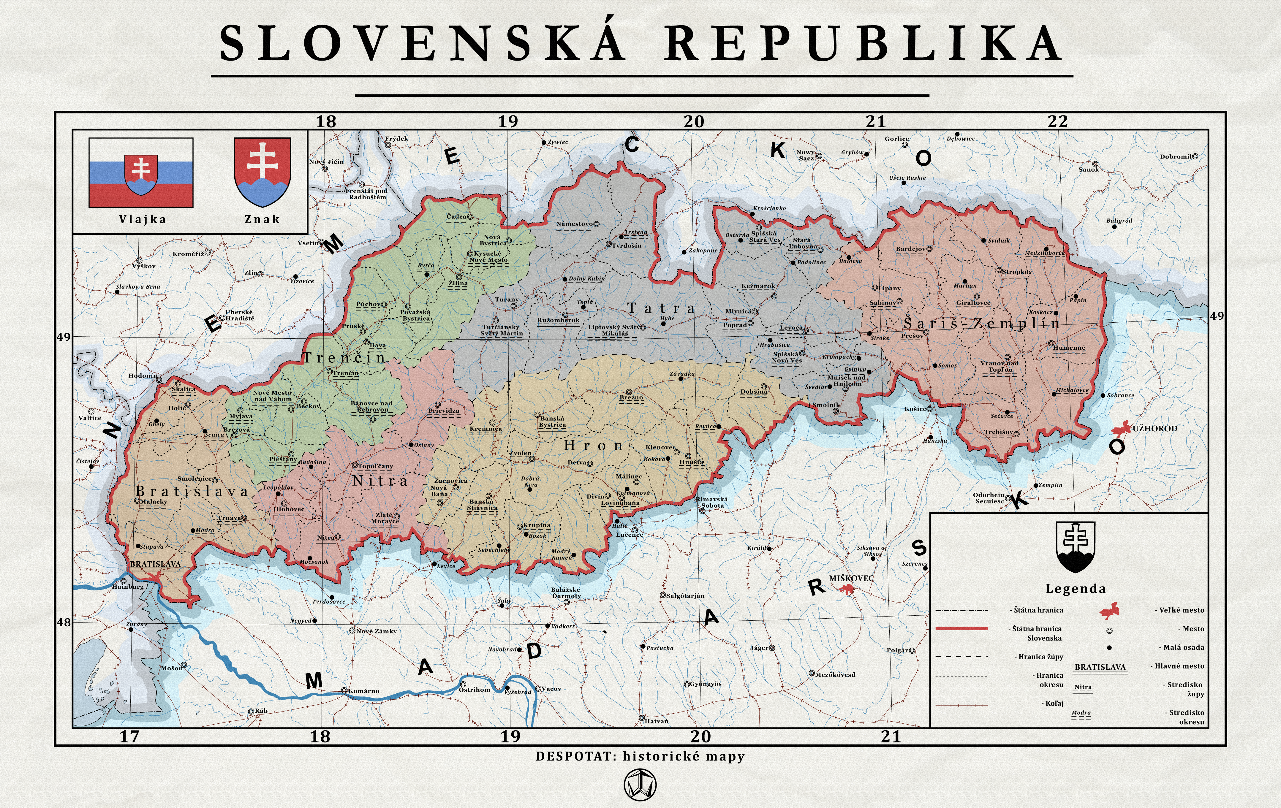
For Slovakia, think it's worse now than vanilla, I said I dint look much at the area XD
1000066313.png
1000066317.jpg

These seems the logical cuts, we missplaced Nitra and expanded too much the plains. Gameplay wise, Nitra can just stay in Bratislava plains without becoming new province.
I see more interesting Trencin hills as a different terrain and key from Brno to Zilina and Banska Bystrica.
Also Banska Bystrica, while a big forest region, is still mountains. I'd prioritize the mountain terrain over the forest.
I still like the idea of Proprad as last mountaing terrain and mandatory way from Banska and Zilina to Presov hills, especially the moment Hungary takes the southern territories and the Lucenec - Kosice way gets locked.
Some accomodation could be done between Komarno and Kosice for Lucenec, as they seem really long now, reshappening that way Komarno marshes with the hills at Lucenec, but this last one its only something rounding my mind. Think the main problem would be lack of spot for the name

PD. I did it with the phone, Hungarian-Slovakian border cant be taken as exact
 
Last edited:
I made new Turkey map also.

I added some provinces with important cities that are missing on the DH map (I checked the census of 1940 for these cities). It is again only suggestions.

I did not implement any blocking point.


- Here is a road map of Turkey in 1930 :


Roads in Turkey - 1930 c..png


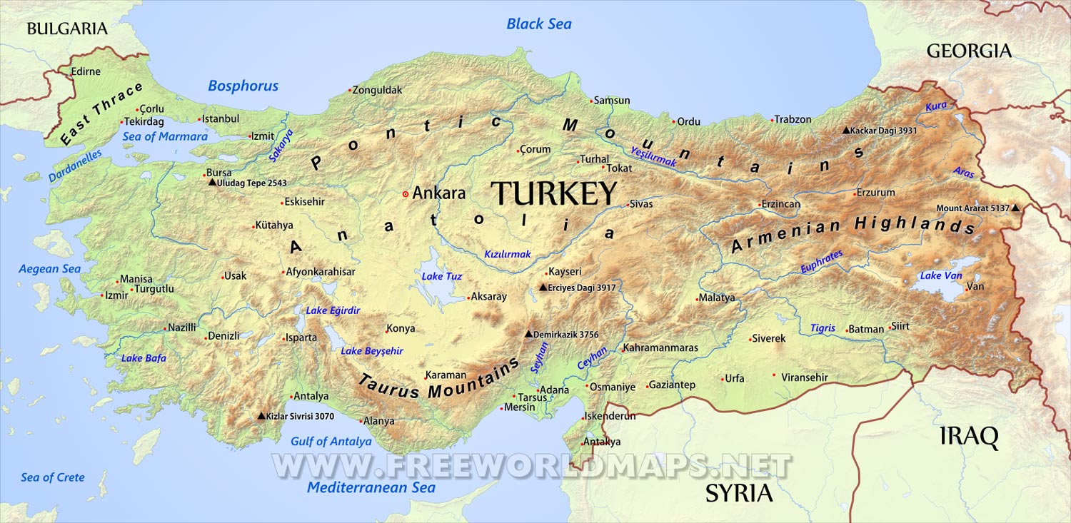
- Here is a geographical map of Turkey :


turkey-physical-map.jpg


- Here is a provinces map of Turkey in the 1930's :

Capture d’écran 2025-04-02 185658.png


Here is a proposed new map of Turkey (with modifications that match relatively these real provinces) :


Turkey modified map.JPG


Explanations will be made later.
 
Last edited:
I moved back to Europe after a trip around the world.

Here I suggest some changes in Romania in order to adjust with the the terrain or to add some medium size important cities:

- Maybe to expand Tulcea southward in Constanta (like it is in reality) ;

- To create Botosani from northern part of Iasi ;

- To create Piatra Neamt form the northern part of Bacau ;

- To create Targu Mures (it is hills instead of moutain) from south part of Bistrita - and to expand it a little bit in Turda ;

- That Sibiu will be at northern part of former province of the same name (it is hills) ;

- To create at southern part of former Sibiu : Petrosani (it is mountain area) ;

- To rename the province 289 : Deva ;

- To create Valcea from northern part of Craiova ;

- To create Targoviste from western Ploesti ;

- I have not indicated any blocking points, I am not sure of the roads at that time.


View attachment 1275610


These changes are based on these maps :


- Physical map of today Romania :

View attachment 1275535

- 1939 Romania map :
(it seems to include many roads or most probably rivers)

View attachment 1275537

- Another map of Romania in 1930 :

View attachment 1275541
About the changes proposed:

It doesnt really mind Alba Iulia or Deva, maybe Deva is more fit but Alba Iulia was a big fortress and stronghold of Austria-Hungary, so I prefer to keep it (and I did province pic for it, so I will alwas drop a tear when loosing one of it), but its true it has to be mountains instead hills.

Targu Mures could be added, or just reshape of Cluj making it reach Miercurea withoutg going by Bistrita.

Petrosani and Brasov can be interesting to make Sibiu hills, but you have to close the connection from Petrosani to Brasov and reshape it a bit, making Sibiu reach Brasov.

Targoviste or Pitesti, the one you like more, seems fine for me.

Ramnicu Valcea, it's nice if you add Targoviste/Pitesti, but then you have to make the way from Giurgiu by Targoviste or Craiova instead direct. And Valcea has to be hills.

Bacau serves well as the nexus in the area, so I don't really see the need of Piatra Neamt, but I'm in favour of chaging its terrain to hills.
For Botosani my point is the same as for Piatra Neamt, think Iasi serves well.
Anyways, big provinces, so lets see what the others think about it.

For Tulcea, expanding the province will have the problem of the river, so you have only one option here, creating a new Tulcea province from northern part of Constanta, making it the pass from Galati to Constanta and a secondary route from Galati to Sulina. Tulcea should be hills in my opinion.
And I don't remember now, did you turn Sulina into plains or is vanilla? It should be marshes without any kind of discussion here.

What I see interesting is the split of Ismail, into Ismail marshes and Cetatea Alba plains, making Ismail connect Cahul and Cetatea Alba Chisinau, with a strait connection to Odessa like the ones in Sicily - Reggio or Denmark.

Somewhat I don't like the plain on Braila cutting the Carpathians, so Buzau or Focsani hills could be used there, also as a way from Ploiesti to Bacau without having to go by the Baragan plain.

I suggest that you implement the changes on the map when you have the time. You seems to have a good knowledge of the area !

It may be good indeed to wait comments of our colleagues before to act.
 
Last edited:
I made new Turkey map also.

I added some provinces with important cities that are missing on the DH map (I checked the census of 1940 for these cities). It is again only suggestions.

I did not implement any blocking point.


- Here is a road map of Turkey in 1930 :


View attachment 1275910


- Here is a geographical map of Turkey :


View attachment 1275911


- Here is a provinces map of Turkey in the 1930's :

View attachment 1275912


Here is a proposed new map of Turkey (with modifications that match relatively these real provinces) :


View attachment 1275914


Explanations will be made later.


Here is the explanations for suggested changes in Turkey :

Most of the city added here had around 80 000 to 150 000 inhabitants in 1940, and they were placed in provinces that are missing in DH map.

- To add Van province from Erzurum and Hakkari. It was a medium size town, and a border province ;

- To add Urda province from Diyarbakir. It was also a medium size town, and a border province ;

- To expand Maltya nortward in Sivas, like in reality ;

- To create Tokat from Samson province. It was a medium size town, and a province ;

- To create Ordu from Samson province. It was a medium size town, and a province ;

- To create Corum from Samson province and Kirrikale province. It was a medium size town, and a coastal province ;

- To create Adapazari from from Zoguldak province. It was a medium size town, and a coastal province ;

- To create Manisa province from westhern Eskisehir province. It was a medium size town, and a province ;

- To create Kutahya from northern Eskisehir province. It was a medium size town, and a province ;

- To create Usak from southern Eskisehir province. It was a medium size town, and a province ;

- To create Aydin from Denizli province. It was a medium size town, and a coastal province ;

- To create Afyonkarahisan Konya province. It was a medium size town, and a province ;

It seems that roads were everywhere in Turkey, so I did not implement blocking connections. I may be wrong, and I am waiting the opinion of expert on this subject !
 
- To create Botosani from northern part of Iasi ;
to make Botosani, yes, very need it

+, to fix name Balti as Beltsi ('Bălți (Romanian pronunciation: [ˈbəltsʲ] ')
I've always wondered wtf that 'Balti' is, insted of normal understandable transliteration as Beltsi.
 
Last edited:
New suggested additionnals provinces as @tioperete said :

- Swansea could be created from Cardiff ;

- York could be created from Leeds & Hull ;


View attachment 1272201


Awaiting comments on my previous maps suggestions, I went back to UK map.


Here is improved suggestions for UK :

(I added many important cities that are missing (I check the 1940 census. All added cities had more then 100 000 inhabitants, often 200 000 to 300 000) ;

(It would be interesting for Air bombing or German invasion (God forbid)) ;

- To separate Norwich in 2 provinces (Norwich & Southend) ;

- To separate Portsmouth in 3 provinces (Portsmouth, Berkshire, Bournemouth) ;

- To separate Oxford in two provinces (Oxford & Luton) ;

- To separate Lincoln in 2 provinces (Lincoln & Leicester) ;

- To separate Birmingham in 2 provinces (Birmingham & Coventry) ;

- To separate Cardiff in 2 provinces (Swansea & Cardiff) ;

- To separate Sheffield in 3 provinces (Sheffield, Leeds, Nottingham) ;

- to separate Manchester in 2 provinces (Manchester & famously : Liverpool) ;

- To separate Hull in 3 provinces (Hull, York, Middlesbrough) ;

- To separate Sunderland in 2 provinces (Sunderland, Newcastle upon Tyne - both were medium size cities) ;


New UK proposed map (it could be improved again int he future) :

UK proposed map.JPG


Uk roads map in 1938 (there is roads everywhere) :

uk-great-britain-roads-1938-vintage-map-FDX4F7.jpg


Uk Geographic map (DH map seems to match it) :


Uk_topo_en.jpg
 
to make Botosani, yes, very need it

+, to fix name Balti as Beltsi ('Bălți (Romanian pronunciation: [ˈbəltsʲ] ')
I've always wondered wtf that 'Balti' is, insted of normal understandable transliteration as Beltsi.

Good point ! I'll let times to Lord Rommel and any others comment it, and I'll work that map again or maybe Tioperete will do it ?
 
Central/Southern Ukraine

The key problem here in vanilla map is Ochakov, It blocks the normal straight paths. There are two intersections in this province... and none of them is Ochakov.
So we need completely change everything here.

- Odessa has become a smaller urban province that can be historically surrounded.
- Ochakov has also become a small province that no longer blocks direct routes and need just to 'surround Odessa' and to provide more short access from Odessa to Nikolaev than through Berezovka.
- Berezovka is a key intersection in this area, through which the roads of the surrounding provinces go - from Balta, Tiraspol, Odessa.
- Pervomaisk has been added as the right logistics hub in this area.
- Balta and Uman have changed their forms to ensure proper logistical links with the surrounding provinces. No more wrong Vinnitsa - Cherkasy direct connection, but Uman - Zhitomir now is.

- cross connection Uman - Balta / Mogilev-Podolsky - Pervomaisk , formally connected by non-straight secondary winding roads.
Therefore, whoever wants, you can make or not make connections here, any options will not be mistake. I'll probably set blocks here just for tactical reasons.

- the other cross-connection is true, to be done.


View attachment 1275632

1938-1940 combine soviet map (this map contains even poor country roads, unlike the General Staff 1941-1942 maps) + some foreign lists
www.etomesto.ru/view.php?map=rkka_europe&key=1&y=50.289762&x=30.940811

ahaha, Turkey list is German and from future, lol
View attachment 1275652

comfortable 1941 General Staff map, but without poor country roads
http://map.etomesto.ru/base/99/euro-1941-08-05-rkka.jpg

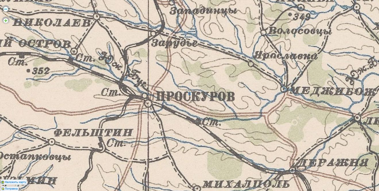
I checked the rest of the Soviet provinces in this zone, and all is OK. The only inaccuracy is that Proskurov is located on the other bank at the confluence of two rivers.
It would be more easy just to change the name for any crossroad in the center of this province for more universal/compromise coordinate point, but since Germany advanced exactly through Proskurov - Vinnitsa - Uman line, ok, let's keep this logictic and keep Proskurov as point of coordinates.
For this, we will act cleverly and will draw the other of these two rivers to leave Proskurov on the bank that we need to follow game concept :D At the same time, this will improve the visibility of Tarnopol-Proskurov connection.

We will fix Soviet Polish and Romanian provinces when we reach these countries.

Ukraine.jpg


Proskurov rivers.jpg


--------------
- Pervomaisk has been added as the right logistics hub in this area.

By the way, it's rather funny, when I added the new Pervomaisk province, I even didn't know that this was the point of convergence of the main German strikes.
That's happens if you tuning DH map just based on the logic of the real logistical connections of the area. :)
Also, I see direct attack vector from Mogilev-Podolsky to Pervomaisk, so looks as this cross-connection should be open.


1941 Ukraine under attack.jpg
 
Last edited:
  • 1
Reactions:
Good point ! I'll let times to Lord Rommel and any others comment it, and I'll work that map again or maybe Tioperete will do it ?
I'm doing it atm as Romania is more or less on the parcel of the map Lord Rommel opened, but for now I'm just concentrating on this parcel and following Nick changes, saying something when I've too, as the USSR was the first part of the world to come here. I know you proposed Turkey, UK, Japan, Australia etc, but each thing I check, I search for old maps, check road an rails in the 30s, mountainous relief, terrain, mountain passes, look for military bases there, important battles etc. Am geographer and historian, or at least that say my degrees, maybe that's the reason I'm obsessively fussy for these things XD
But one thing at a time. If am looking at Europe, can't divert to Turkey, then Japan etc so when you open the revision of a new region, I look a bit at it, see some things but I don't deepen to the question.
 
  • 1Love
Reactions:
Good point ! I'll let times to Lord Rommel and any others comment it, and I'll work that map again or maybe Tioperete will do it ?

Didnt draw the provinces.

Painted terrain corrections and corrected rivers (dark blue, light blue is to show erroneus river curse). I know some regions are better done than others, but Romania was poorly managed honestly.

Is difficult to work with the romanian rivers, so maybe the devs took an approach modeling the region in an aproximate way.

You have the locations in the map of all cities from the old provinces and the ones you proposed. As you can see Sibiu is a bit out of place but Petrosani is completely missplaced.

Deva true position is marked in garnet-cyan circle, while not modifing the river would be in cyan-garnet river. Old Alba Iulia was missplaced in side of the river, green-garnet circle, true position with corrected river in garnet-green.

Buzau and Focsani are marked in orange-garnet, same as Cetatea Alba.

Also shown Pitesti location close to Targoviste if you prefer it, as it a bit more in the crossroad.

As a scheme for develop your map it should serve.


Romania modified map.jpeg
 
Didnt draw the provinces.

Painted terrain corrections and corrected rivers (dark blue, light blue is to show erroneus river curse). I know some regions are better done than others, but Romania was poorly managed honestly.

Is difficult to work with the romanian rivers, so maybe the devs took an approach modeling the region in an aproximate way.

You have the locations in the map of all cities from the old provinces and the ones you proposed. As you can see Sibiu is a bit out of place but Petrosani is completely missplaced.

Deva true position is marked in garnet-cyan circle, while not modifing the river would be in cyan-garnet river. Old Alba Iulia was missplaced in side of the river, green-garnet circle, true position with corrected river in garnet-green.

Buzau and Focsani are marked in orange-garnet, same as Cetatea Alba.

Also shown Pitesti location close to Targoviste if you prefer it, as it a bit more in the crossroad.

As a scheme for develop your map it should serve.


View attachment 1276130

All right, thanks for all these informations. It is quite precise !

It is quite difficult to correctly place the cities on the map considering the shape of western Carpathians, and the muliples rivers going everywhere.

As Lord Rommel said he will do the map during the weekend, I'll let him do the modifcations unless that he changes his mind. The work that he has done in western Europe with your help is phenomenal, and both of you have a greater knowledge of western Europe geography and territorial divisions then myself.

If Vilochka really implements these proposals, the game will be greatly enhanced.

I'll move back to Australia, Japan and Canada to make a second check up and improvements maybe.

I don't know if others Asian countries need improvement, maybe : French Indochina, Malaysia, Burma, Netherlands east India. I might verify and suggest minor changes.

At the end, Vilochka will decide what he accepts and refuses, and he will have a wide variety of choice. I would prioritise changes in western Europe after that USSR will be done obviously.
 
I checked the rest of the Soviet provinces in this zone, and all is OK. The only inaccuracy is that Proskurov is located on the other bank at the confluence of two rivers.
It would be more easy just to change the name for any crossroad in the center of this province for more universal/compromise coordinate point, but since Germany advanced exactly through Proskurov - Vinnitsa - Uman line, ok, let's keep this logictic and keep Proskurov as point of coordinates.
For this, we will act cleverly and will draw the other of these two rivers to leave Proskurov on the bank that we need to follow game concept :D At the same time, this will improve the visibility of Tarnopol-Proskurov connection.

We will fix Soviet Polish and Romanian provinces when we reach these countries.

View attachment 1276090

View attachment 1276096

--------------


By the way, it's rather funny, when I added the new Pervomaisk province, I even didn't know that this was the point of convergence of the main German strikes.
That's happens if you tuning DH map just based on the logic of the real logistical connections of the area. :)
Also, I see direct attack vector from Mogilev-Podolsky to Pervomaisk, so looks as this cross-connection should be open.


View attachment 1276098


You have access to good map in russian ! It a chance, because I don't read russian at all, I could only rely on english or french map.

Do you consider the size of cities for implementing your modifications ? Does the DH map was already reasonnably done about important cities in USSR ?

Will you check the Soviet Far East in case of Soviet-Japanese war or it is well done in your opinion ?
 
You have access to good map in russian ! It a chance, because I don't read russian at all, I could only rely on english or french map.
Actually, I believe that by the end of our work, you all will have learned Russian alphabet and will be able to read these Soviet maps easily.
At least, my English son-in-law learned Russian alphabet in a couple days and so he is able perfectly to read menu in Russian restarans. :D

They're really quite good, these three maps 1938-1940 / 1941 / 1942

1938-1940
www.etomesto.ru/view.php?map=rkka_europe&key=1&y=49.425209&x=27.125322

1941
http://map.etomesto.ru/base/99/euro-1941-08-05-rkka.jpg

1942
http://map.etomesto.ru/base/99/euro-1942-04-20-rkka.jpg

They cover the whole of Europe and even partially capture the Middle East and North Africa.
The second two maps are comfortable for the eyes, good for viewing from afar, do not have secondary roads, but the main highways are highlighted in yellow and therefore differ good from the "improved dirt roads".

And the first 1938-1940 map even contains minor poor country roads of local importance for USSR. Now I always check the connections along it, because where I thought there are no roads, it turns out they are, although poor and winding.
Do you consider the size of cities for implementing your modifications ? Does the DH map was already reasonnably done about important cities in USSR ?
I am using the first two maps for a general understanding of the logistics of the region and the size of the cities.
Naturally, I try to choose a large city for the name of the province, if it is suitable as the main logistics hub. But this is not a law for me. If a large city is not suitable for the role of logistics hub at all, I can easily assign a small village to this role, but which is located at a key/strategic crossroads in this area.

For example, when I moved Bryansk to the right side of the river, the question arose - what would be the name of the old province? There is a really large town Ordzhonikidzegrad opposite Bryansk, the the only large town in this province. But it is completely unsuitable for the role of the main logistics hub of the province. That's why I named province as Kirov - it's a key crossroads of strategic roads in this area, but the town itself was officially recognized as a town only in 1936(!), it's a fairly new born small settlement.

In other words, it is not absolutely necessary for me to put large cities on maps. If large cities are in a good logistical location (usually they are), it's OK. If they are away from the key roads and intersections of the province, I can easily ignore them, for me this is not a sacred cow.
Does the DH map was already reasonnably done about important cities in USSR ?
Therefore, for me, such an aim is not worth it at all, it takes absolutely no difference to me whether all major cities are mapped or not.
I care only about high-quality implemented reasonable and some times even historical military logistics.

Will you check the Soviet Far East in case of Soviet-Japanese war or it is well done in your opinion ?
In our old multiplayer community, Japan's war with the USSR (before the fall of Stalingrad and Moscow) was always prohibited by the rules, so for me this is a very secondary region for improving the map.

I think we should first create the most sought-after war zone - European theater. And after that, we can finalize this first version ('Light version') of the map so that the modders can already transfer their mods to it and release versions on the new map.

And then we can safely continue work on the rest of war regions.
 
Last edited:
So when I understand it correct a "cross connection" is the ability to get into the other province even when there is just the smalles 1pixel big connection?

When this is the case I have to say that such a concept is a nightmare because the map's visual Design isnt telling the information. So i think from a map Design point of view there should be no cross connections. All pathways should be visible by map Design.

My2cents.
 
  • 2
Reactions:
So when I understand it correct a "cross connection" is the ability to get into the other province even when there is just the smalles 1pixel big connection?

When this is the case I have to say that such a concept is a nightmare because the map's visual Design isnt telling the information. So i think from a map Design point of view there should be no cross connections. All pathways should be visible by map Design.

My2cents.

By a way or another, each modder will have the opportunity to block accesses that he disagrees. To some extent, the map province are fictious and you go through any territory that is close to a province unless a real blocking point.