• We have updated our Community Code of Conduct. Please read through the new rules for the forum that are an integral part of Paradox Interactive’s User Agreement.

Tinto Maps #15 - 23rd of August 2024 - Horn of Africa

Hello, and welcome one more week to Tinto Maps! After a short break, we’re back to the duty of sharing more maps! Today the region we will look at is the Horn of Africa! So let’s take a look at it, without further ado:

Countries:
Countries.PNG

Here we have the countries around Nubia, Ethiopia, and Somalia. The first ones are organized around the ancient kingdoms of Makuria and Alodia, which control the Upper Nile region. In the second area, the Empire of Ethiopia stands as the main power, with some smaller countries around it. Finally, the two Islamic sultanates of Ifat and Ajuraan stand as the main powers in the Horn and Somalia. Finally, around the African Great Lakes, there is a country that can be considered a ‘settled’ one, Kitara.

Dynasties:
Dynasties.PNG

The dynasties of the Horn. There are some historical ones, while others are randomly generated. The most famous one is probably the Ethiopian House of Solomon, from where all their Negus come. The Walshma ruler over both Ifat and Ajuraan and we have some others, such as the Medri of Medri Bahri, the Umar of Mogadishu, the Banu Kanz of Makuria, or the Baranzi of Kitara.

Societies of Pops:
Pop-Based.PNG

A new map has popped up! Here you can see the countries that we consider as ‘Societies of Pops’, as they were presented in the last Tinto Talks. We have the famous Oromo people in the lands between Ethiopia, Ifat and Ajuraan; the Kunama, Gumuz, and Berta in the lands between Ethiopia; and Alodia, and the Zaghwa to the north of Wadai; there are a few more to the west, but I’ll share that picture in the Western Africa thread, as it’s more appropriate there. There are more Stateless Societies of this kind that we would like to add in the future, if it is possible due to our schedule.

Locations:
Locations.PNG

Locations 2.png

Locations 3.png

Locations 4.png

Locations 5.png
Locations! You might notice that the density is quite unequal. Unfortunately, the archaeological findings for the period are scarce, specially out of the most known areas and a lack of urbanization in most of the territory has made the finding of proper non-anachronistic settlements quite a challenge. Keep this in mind when making suggestions. ;) It has been that dramatic in some areas that we had to use names of tribes and rivers, a bit contradicting our own rules, but the areas had to be represented as they were active parts in the development of the region.
One thing: a big chunk of the Arabian peninsula can be seen in today’s Tinto Maps; but, please, reserve the feedback for its future DD, when we’ll show all of the peninsula. Apart from that, you can see more detailed maps if you click on the spoiler button, as usual.


Provinces:
Provinces.png


Areas:
Areas.png


Terrain:
Climate.png

Vegetation.png

Topography.png

The terrain types of the region are quite interesting and diverse. It is marked by the Rift Valley, which creates different biomes, such as the Ethiopian Highlands and Plateau, or the African Great Lakes. That also marks a divide between Arid, Tropical, and Oceanic climates. The vegetation of the region also ranges from desertic and sparse, to jungle forests. And one more note: you may also note that 'Marshes' have been renamed into 'Wetlands', as we could put some work into that suggestion the last week.

Natural Harbors:
Natural Harbors.png


Cultures:
Cultures.png

Another interesting map this week… You might notice that the lands of Ethiopia have a very mixed cultural situation. While more to the west and south, we are representing ‘tribal lands’ in a more homogeneous way, with kind of fixed boundaries to represent the different groupings. This doesn’t mean that there wouldn’t be a mixing of cultures, but this was one of the first areas to receive a minority's review and the scope was limited mostly to Ethiopia.

Religion:
Religion.png

Another interesting map! Miaphysite and Sunni are the more widespread religions in the region (while not all areas have their mixed populations, such as Nubia as you might notice, they eventually will as we cover more of the map in our sprints). Animism is completely placeholder, as usual, and you might see some pockets here and there (If you have specific suggestions, please do them). You may also notice a purple minority inside Ethiopia… That is representing the Beta Israel Judaism in the provinces of Semien, of course!

Raw Materials:
Raw Materials.png

The raw materials of this week! A big chunk of the region has livestock as its main raw material, while also having some agricultural goods as Wheat or Sturdy Grains here and there. The most unique good in the region is Coffee, which is cultivated in the Ethiopian highlands. And there are also some precious resources spread here and there, such as Gold, Ivory, Gems, and Incense.

Markets:
Markets.png

The main market centers of the region are Axum and Mogadishu, with ‘Adan/Aden being the main one controlling the access to the Red Sea. There are some weird calculations ongoing on the Somalian inner lands, that are already reported, and we’ll take a look at why is that happening.

Population:
Population.png

Population 2.png

Population 3.png

Population 4.png

Population 5.png
The population of the region! There are approximately 12.3M people in the Eastern African subcontinent; although take into account that it also comprises the regions of the Southern Great Lakes and the Swahili Coast, which we haven’t shown today, so we probably have to discount around 4M people from it (Swahili Coast accounts for 1.7M, and the Great Lakes for 4M, although that region is divided between today’s and next week’s Tinto Maps), for a total of around 8M.

That’s all for today! Speaking of next week’s Tinto Maps, it will be meaty, as it will cover Central, Eastern, and Southern Africa! See you!
 
  • 126Like
  • 39Love
  • 5
  • 4
  • 1
Reactions:
There are areas in this regions which are akin to Europe (Ethiopia), and from there, the location density needs to be augmented, as other areas need to have bigger locations to make them fit. As we've already said, it doesn't make sense for us to have the same location in the whole world as in the Holy Roman Empire.
Just in terms of moving armies around, bigger locations give you fewer options which is less interesting. It's cheaper and easier to fortify a border with fewer locations, and armies will presumably take longer to move through them giving more time to intercept or increasing how long it takes reinforcements to arrive to an ongoing battle. There are definitely knock on effects to global variation in location size.
 
  • 9
  • 1Like
Reactions:
Regarding Societies of Peoples, I outright feel... deceived.

The 14th August Tinto Talks on colonization seems set up to make us believe that Stateless Societies were the replacement for usual Europa Universalis natives, analogous to Vic3's Decentralized Nations: Johan wrote about needing to overpower "countries in plural, and next week you will understand what we are talking about" like it's something you always deal with, and then showed a map of Scandinavia where every single uncolonized province was covered by some "[name] People" tag.

Then this Tinto Maps drops, and it turns out no, in large chunks of the world colonizers will find "empty" land and people that have little to no agency like in EU4 or Victoria II. I was hoping for better.
Yeah a bit disappointed it seems like such an intuitive system but doesn't seem to be utilized properly to depict the plethora of states and societies particularly in Africa and the new world i think some of the criteria that Pavia laid out seemed quite restrictive and unduly limiting especially if he meant by a combination of all those aspects rather than a single on being enough to justify a proper depiction i hope its the latter and not the former
 
  • 2Like
Reactions:
Vaguely surprised nobody has brought this up but I don't think Lake Victoria or the area around it should be named that at this time

I'd rename the provinces north of the lake after local villages or people and the lake itself has a number of names: Ukerewe from Swahili and Nyanza from Kinyarwanda make the most sense to me. They both have problems with not being universal terms among local languages but both are significantly better options than a British monarch who likely didn't live during the period of the game
Albeit being correct, this is -imo- inapplicable: we should rename a lot o places: Georgia, Louisiana, Strait of Magellan...
Yeah a bit disappointed it seems like such an intuitive system but doesn't seem to be utilized properly to depict the plethora of states and societies particularly in Africa and the new world i think some of the criteria that Pavia laid out seemed quite restrictive and unduly limiting especially if he meant by a combination of all those aspects rather than a single on being enough to justify a proper depiction i hope its the latter and not the former
I think the criterion is if those people can act as one entity or is just a bunch of isolated communities.
 
What is rather fascinating is the inclusion of the northern Somali coast to the Axum market. We are talking about an era that lacked railroads. It was far, far easier sailing from say Berbera or any town on the African side of the Gulf of Aden to Aden itself than crossing the Rift Valley and moving uphill into Axum. Thats actually, why the area ended being Muslim rather than Christian.

Also the area is mentioned as far back as in the antinquity (https://navigating-the-periplus.github.io/maps/). Its apparent that the area was in contact with the Malabar coast and Swahili coast, unlike the Ethiopian Highlands.

As I guess has been suggested earlier, Zeila ( ) should be its own market, covering the Afar and Ifat.
 
  • 4Like
  • 3
  • 2
Reactions:
1724484439888.png

A sattelite map of the Horn of Africa region.
1724484573029.png

What is one of the most recognizable features in this part of Africa?
Yes, it is the Afar triangle, a dry lowland area roughly similar in size to the northern half of the Ethiopian Highlands. It is a geographicallly well defined area-- which posits the question: why is Afar not shown as a separate "Area" but is rather split among "Northern Ethiopia", "Central Ethiopia", "Northern Somalia" and "Inner Somalia"?
Also given the steep cliff between the Ethiopian Highlands and the Afar Triangle, I would have expected a few wastelands to portray that natural barrier, with several locations connecting the two, but not portraying this geographical barrier in any way is just odd, as it was a religious (Christian-Muslim) and linguistic (Ethiosemitic-Cushitic) border
 
  • 15Like
  • 5
  • 2
Reactions:
View attachment 1178717
A sattelite map of the Horn of Africa region.
View attachment 1178719
What is one of the most recognizable features in this part of Africa?
Yes, it is the Afar triangle, a dry lowland area roughly similar in size to the northern half of the Ethiopian Highlands. It is a geographicallly well defined area-- which posits the question: why is Afar not shown as a separate "Area" but is rather split among "Northern Ethiopia", "Central Ethiopia", "Northern Somalia" and "Inner Somalia"?
Also given the steep cliff between the Ethiopian Highlands and the Afar Triangle, I would have expected a few wastelands to portray that natural barrier, with several locations connecting the two, but not portraying this geographical barrier in any way is just odd, as it was a religious (Christian-Muslim) and linguistic (Ethiosemitic-Cushitic) border
Tangentially related but I would have also expected some more wastelands along the Rift too
 
  • 2Like
Reactions:
Hello, and welcome one more week to Tinto Maps! After a short break, we’re back to the duty of sharing more maps! Today the region we will look at is the Horn of Africa! So let’s take a look at it, without further ado:

Countries:
View attachment 1178432
Here we have the countries around Nubia, Ethiopia, and Somalia. The first ones are organized around the ancient kingdoms of Makuria and Alodia, which control the Upper Nile region. In the second area, the Empire of Ethiopia stands as the main power, with some smaller countries around it. Finally, the two Islamic sultanates of Ifat and Ajuraan stand as the main powers in the Horn and Somalia. Finally, around the African Great Lakes, there is a country that can be considered a ‘settled’ one, Kitara.

Dynasties:
View attachment 1178433
The dynasties of the Horn. There are some historical ones, while others are randomly generated. The most famous one is probably the Ethiopian House of Solomon, from where all their Negus come. The Walshma ruler over both Ifat and Ajuraan and we have some others, such as the Medri of Medri Bahri, the Umar of Mogadishu, the Banu Kanz of Makuria, or the Baranzi of Kitara.

Societies of Pops:
View attachment 1178434
A new map has popped up! Here you can see the countries that we consider as ‘Societies of Pops’, as they were presented in the last Tinto Talks. We have the famous Oromo people in the lands between Ethiopia, Ifat and Ajuraan; the Kunama, Gumuz, and Berta in the lands between Ethiopia; and Alodia, and the Zaghwa to the north of Wadai; there are a few more to the west, but I’ll share that picture in the Western Africa thread, as it’s more appropriate there. There are more Stateless Societies of this kind that we would like to add in the future, if it is possible due to our schedule.

Locations:
View attachment 1178435
Locations! You might notice that the density is quite unequal. Unfortunately, the archaeological findings for the period are scarce, specially out of the most known areas and a lack of urbanization in most of the territory has made the finding of proper non-anachronistic settlements quite a challenge. Keep this in mind when making suggestions. ;) It has been that dramatic in some areas that we had to use names of tribes and rivers, a bit contradicting our own rules, but the areas had to be represented as they were active parts in the development of the region.
One thing: a big chunk of the Arabian peninsula can be seen in today’s Tinto Maps; but, please, reserve the feedback for its future DD, when we’ll show all of the peninsula. Apart from that, you can see more detailed maps if you click on the spoiler button, as usual.


Provinces:
View attachment 1178440

Areas:
View attachment 1178441

Terrain:
View attachment 1178442
View attachment 1178443
View attachment 1178444
The terrain types of the region are quite interesting and diverse. It is marked by the Rift Valley, which creates different biomes, such as the Ethiopian Highlands and Plateau, or the African Great Lakes. That also marks a divide between Arid, Tropical, and Oceanic climates. The vegetation of the region also ranges from desertic and sparse, to jungle forests. And one more note: you may also note that 'Marshes' have been renamed into 'Wetlands', as we could put some work into that suggestion the last week.

Natural Harbors:
View attachment 1178446

Cultures:
View attachment 1178447
Another interesting map this week… You might notice that the lands of Ethiopia have a very mixed cultural situation. While more to the west and south, we are representing ‘tribal lands’ in a more homogeneous way, with kind of fixed boundaries to represent the different groupings. This doesn’t mean that there wouldn’t be a mixing of cultures, but this was one of the first areas to receive a minority's review and the scope was limited mostly to Ethiopia.

Religion:
View attachment 1178448
Another interesting map! Miaphysite and Sunni are the more widespread religions in the region (while not all areas have their mixed populations, such as Nubia as you might notice, they eventually will as we cover more of the map in our sprints). Animism is completely placeholder, as usual, and you might see some pockets here and there (If you have specific suggestions, please do them). You may also notice a purple minority inside Ethiopia… That is representing the Beta Israel Judaism in the provinces of Semien, of course!

Raw Materials:
View attachment 1178449
The raw materials of this week! A big chunk of the region has livestock as its main raw material, while also having some agricultural goods as Wheat or Sturdy Grains here and there. The most unique good in the region is Coffee, which is cultivated in the Ethiopian highlands. And there are also some precious resources spread here and there, such as Gold, Ivory, Gems, and Incense.

Markets:
View attachment 1178450
The main market centers of the region are Axum and Mogadishu, with ‘Adan/Aden being the main one controlling the access to the Red Sea. There are some weird calculations ongoing on the Somalian inner lands, that are already reported, and we’ll take a look at why is that happening.

Population:
View attachment 1178451
The population of the region! There are approximately 12.3M people in the Eastern African subcontinent; although take into account that it also comprises the regions of the Southern Great Lakes and the Swahili Coast, which we haven’t shown today, so we probably have to discount around 4M people from it (Swahili Coast accounts for 1.7M, and the Great Lakes for 4M, although that region is divided between today’s and next week’s Tinto Maps), for a total of around 8M.

That’s all for today! Speaking of next week’s Tinto Maps, it will be meaty, as it will cover Central, Eastern, and Southern Africa! See you!
Cool stuff! I do hope you rename "Societies of Pops" to "Stateless Societies". That sounds much better imo. Looking forward to a Kitara run at some point.
 
  • 3Like
  • 3
Reactions:
Ethiopian Jews are the some of the only Jews in the world that practice a non-Talmudic form of Judaism. There are several of theories that try to answer why this is the case but a historical belief is that they originate from ancient Israel and left Israel for modern day Ethiopia during the reign of King Solomon.

In the Old Testament of the Bible, 1 Kings 10 recounts a story where the Queen of Sheba, an Ethiopian queen, had an affair with King Solomon and produced a son, whose name was Menelilk. The Queen of Sheba was to return to her kingdom with her new born baby and King Solomon gave her 1,000 men to go with her to protect her during her journey. Those 1,000 men were to be what we call Beta Israel or Ethiopian Jews. They would still practice a non-Talmudic form of Judaism as Judaism hadn't "produced" the Talmud yet. The Ethiopian Jews for centuries believed that they were the last Jews and stories about Jerusalem's greatness had been passed down for generations and generations.

And by the way that new born baby Menelik was to be the first member of the Solomonic Dynasty which would last until the 1970s after the Ethiopian revolution.
View attachment 1178512
Thanks for the info.
 
Why was Ifat so large when it seemingly should have been smaller? According to the Arabic historian al-Umari, Ifat encompassed seven major towns: Bequlzar, Kuljura, Shimi, Shawa, Adal, Jamma, and Lao (The Ethiopian Borderlands, p. 46).

"The rapid expansion of Ifat can be attributed to its determined effort to dominate all Muslim regions. This ambition, however, was met with substantial local resistance, forcing the Walasma dynasty to launch military campaigns against various territories. Mora, Adal, Hobat, and Zatanbar were among the regions attacked and subsequently occupied, marking the rise of Ifat’s predominance in the Muslim areas" (Church and State in Ethiopia, p. 245).

'Umar Walasma played a crucial role in consolidating this power during the late thirteenth century. He extended his control over other Muslim principalities from Shewa to Hubat, near present-day Harar (Church and State in Ethiopia, p. 254). However, despite its impressive territorial reach, Ifat lacked direct political influence in areas such as Dewaro and Sarka, which limited its overall power (Church and State in Ethiopia, p. 265). Notably, Dewaro is located north of Bali.

No mention of states from the east of the above^, I don't think Ifat stretched into southern somaliland, let alone puntland, I'm happy to be proven wrong though...

Rough Estimate Of What Ifat's core was..
View attachment 1178691

View attachment 1178684
I was under the impression Ifat just controlled the Harar Plateau and the eastern areas were stateless
 
What is rather fascinating is the inclusion of the northern Somali coast to the Axum market. We are talking about an era that lacked railroads. It was far, far easier sailing from say Berbera or any town on the African side of the Gulf of Aden to Aden itself than crossing the Rift Valley and moving uphill into Axum. Thats actually, why the area ended being Muslim rather than Christian.

Also the area is mentioned as far back as in the antinquity (https://navigating-the-periplus.github.io/maps/). Its apparent that the area was in contact with the Malabar coast and Swahili coast, unlike the Ethiopian Highlands.

As I guess has been suggested earlier, Zeila ( ) should be its own market, covering the Afar and Ifat.
Damot also sold their gold through Zeila https://www.persee.fr/doc/ethio_0066-2127_2014_num_29_1_1572
 
Last edited:
  • 1
Reactions:
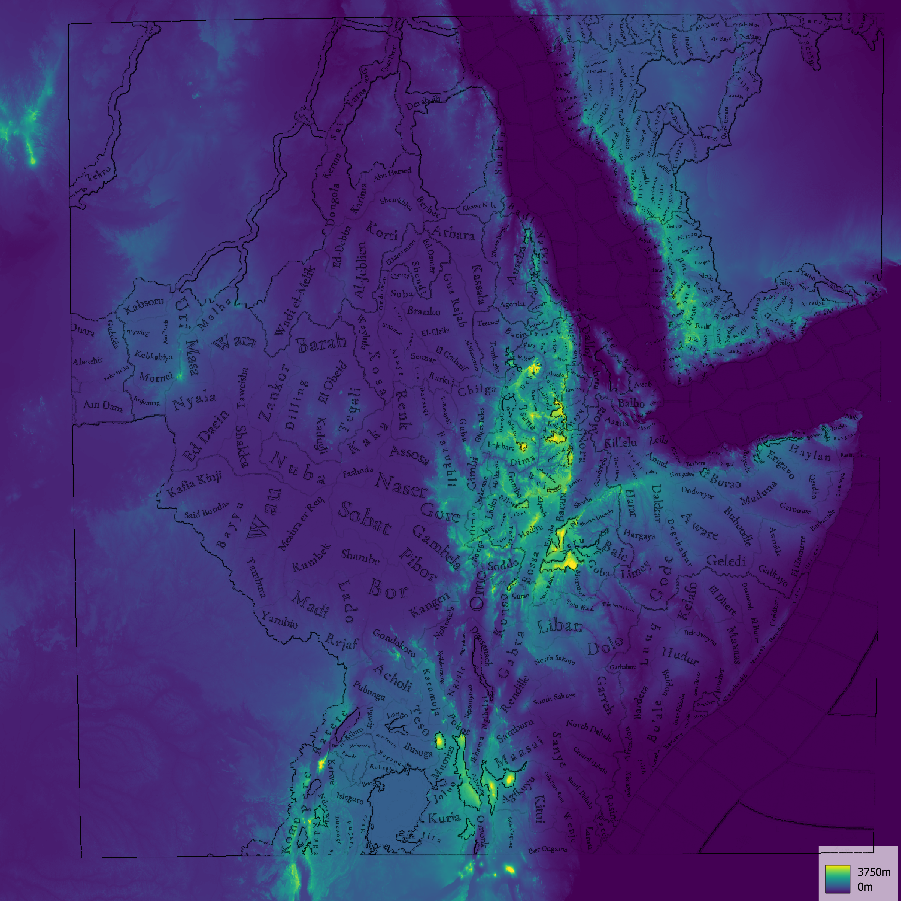
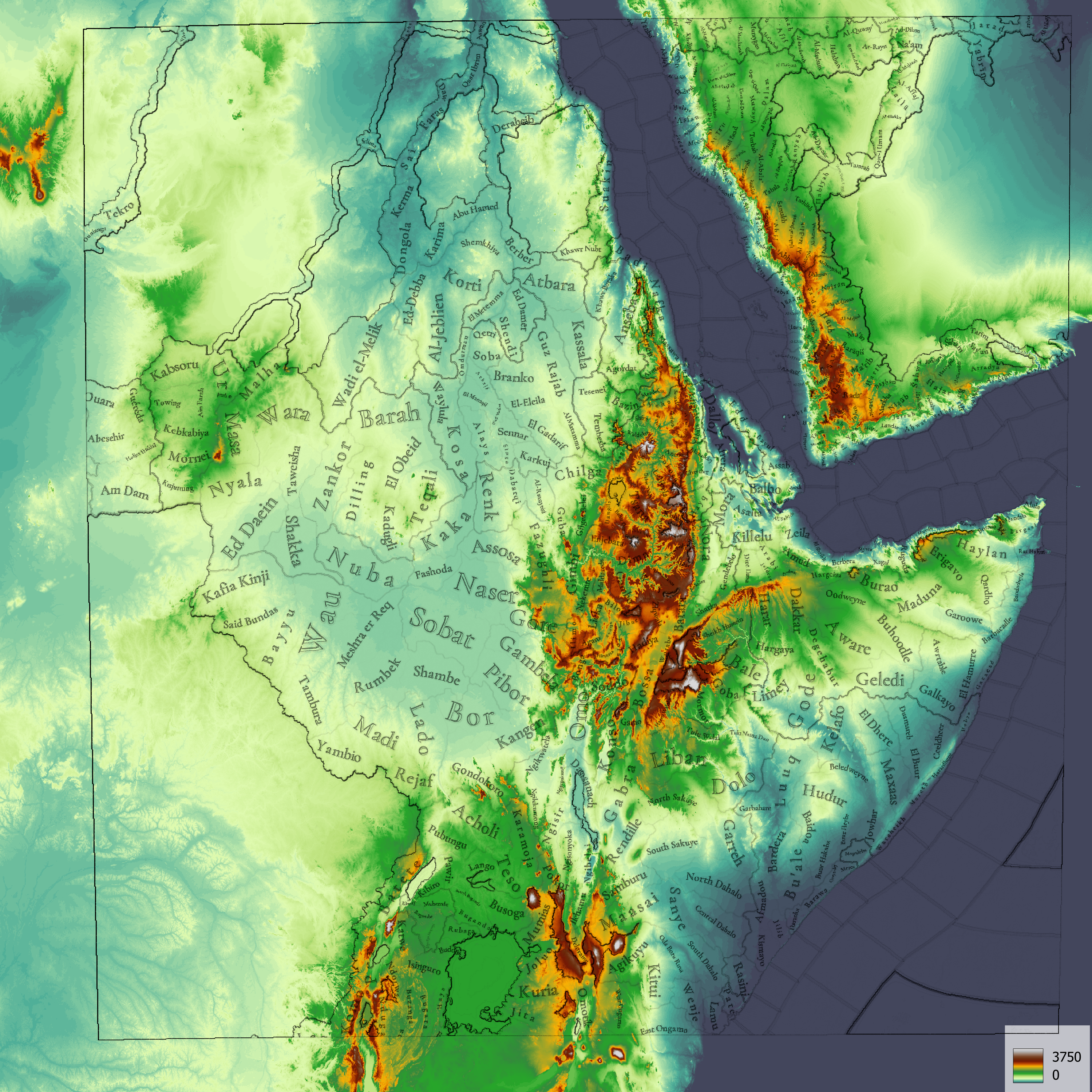
Topography analysis time!

I was both looking forward and dreading to review this region, as this is a véry complex region topograpy wise.
Underneath I present my view on how the topography should or could be expressed, but realise that there are many many ways one could redesign this map.

As this map is HUGE, i made 3000x3000 px maps this time around.

I sunk a good 6 hours into reviewing the topography for this Tinto Maps, so here goes nothing.

Summary:
  • The mountains and hills of Southern Arabia should be more pronounced with the addition of a few more impassable ranges
  • Ethiopian rift could to do with lots more mountains and hills
  • The wetlands of Bahr al Jabal should extend to more locations according to the Peatlands map (Peat-ML) and Tropical+SubTropical Wetlands map (Global Wetlands)
  • The East African Rift system is too extreme in indication of both mountain ranges and impassable ranges
This time no extensive changelog, because dear goodness there are a lot of locations!

As usual, potential 'ridge crossings' as purple lines. Again, I made my topographical suggestions independently of these crossings, so feel free to ignore them while interpreting these maps.
Current Topography according to TintoSuggested Topography'Changelog' of suggested topography
Topography_TintoCurrent.png
Topography_SuggestionsOnTopography.png

erratum: Gamo should be plateau or hills, mountains is too severe
Topography_SuggestionsOverview.png

erratum: Gamo should be plateau or hills, mountains is too severe

Terrain Ruggedness Index, with an aditional indication of plateaus >2500 m in heightLinear colorscale DEM
(0 - 3750 m)
Exaggerated Lower Topography
(0 - 3750 m)
TRI_hPlateau.png
Topography_DEM_Viridis.png
Topography_DEM_Colorful.png

Distribution of Wetlands according to the Peat-ML mapTropical+SubTropical Wetlands map (Global Wetlands)
Topography_Wetlands.png
VEG_CIFOR2016_wetlandsv3b.png
 

Attachments

  • VEG_Wetlands_Tropical_2016_v3b.png
    VEG_Wetlands_Tropical_2016_v3b.png
    5 MB · Views: 0
Last edited:
  • 18Love
  • 15Like
  • 3
Reactions:
@SaintDaveUK - something that has been bothering me for a while is that wetlands and hills have a very similar map color. (I know I have issues with it as a colorblind person). Perhaps a slightly more bluish and slightly darker hue could be appropriate?

Just a thought.
1724490855751.png
1724490916402.png
 
  • 23Like
  • 3
  • 1Love
Reactions:
@SaintDaveUK - something that has been bothering me for a while is that wetlands and hills have a very similar map color. (I know I have issues with it as a colorblind person). Perhaps a slightly more bluish and slightly darker hue could be appropriate?

Just a thought.
While I'm prety sure that's just a colorblindness issue I think its a good think to try to make strategy games (that often rely heavily on colour coding stuff) more accesible for people with colour blindness, so that's a nice suggestion.
 
  • 4
  • 1
Reactions:
Raw Materials:
View attachment 1178449
The raw materials of this week! A big chunk of the region has livestock as its main raw material, while also having some agricultural goods as Wheat or Sturdy Grains here and there. The most unique good in the region is Coffee, which is cultivated in the Ethiopian highlands. And there are also some precious resources spread here and there, such as Gold, Ivory, Gems, and Incense.
Pardon my ignorance, but what does "sturdy grains" represent? I figure non-cereal grains (in this region I assume it's representing lovegrass specifically)?
Also what would "medicaments" represent? Ingredients for medicine (be it traditional medicine or what little you can call actual medicine at this time)?
 
  • 1
Reactions:
Looking at this I am curious how you will protray the " sinti and roma " people in europa (and I gues anatolia at that time)
We didn't have the proper tools to portray them correctly, I think. Maybe we could have them, but there are a couple of things that we'd need to have first, and I'm not entirely sure if we'll get them.
They probably won't... again :/ I know that response has a modicum of hope, but it's kinda the same response we got with other games (including my thread about roma representation pre-vicky 3's release). At this point i've resigned myself to the fact that i'm never gonna see my people represented in any paradox game that wants to "simulate every person alive", unless someone mods it in.
 
  • 2Like
  • 1
Reactions:
Do we get an option like "Abyssinian Empire vs. Ethiopian Empire"?
 
Others have already mentioned this but I will mention it again, the name of the country Afar should be changed to Dankali because that was the name of this kingdom.
Quote from the link below:

The earliest surviving written mention of the Afar is from the 13th-century Andalusian writer Ibn Sa'id, who reported that they inhabited the area around the port of Suakin, as far south as Mandeb, near Zeila. They are mentioned intermittently in Ethiopian records, first as helping Emperor Amda Seyon in a campaign beyond the Awash River, then over a century later when they assisted Emperor Baeda Maryam when he campaigned against their neighbors the Dobe'a. According to sixteenth century Portuguese explorer Francisco Álvares, the kingdom of Dankali was confined by Abyssinia to its west and Adal Sultanate in the east.

I propose to add the following cities/villages to the Danakil region: Tiyo, Berhale, Teru, Bidu and Girrifo.
Biru-Girrifo.png

Teru.png
The village of Teru was the capital of the Teru Sultanate
The villages of Biru/Bidu and Ghiriffo/Girrifo were the capitals of the Girrifo/Biru Sultanate.
As for Berhale, I don't know if it is a good choice, but I wanted to present the borders of the Tigray region on the map because this location was later part of Ethiopia.
This is clearly visible on the Ethiopian map below, where this location is part of Tigray as a province.

Ethiopian map from 1886.

DVBRG4fV4AEa2BG.jpg

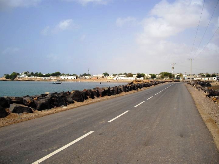
The Kingdom of Dankali should not control the cities of Assab, Raheita, Obock and Tadjoura they should belong to the Ifat Sultanate.
Quote from the link below
During the Middle Ages, Obock was ruled by the Ifat Sultanate and then the Adal Sultanate.

AFAR.png

Dankali.png

In the link below on page 51 there is a map of the region with important towns and villages in the region.
dft.png


Last edited:
  • 11Like
  • 5
  • 1
Reactions: