• We have updated our Community Code of Conduct. Please read through the new rules for the forum that are an integral part of Paradox Interactive’s User Agreement.

Tinto Maps #20 - 27th of September 2024 - The Steppes

Hello, and welcome one more week to the weekly encounter for map lovers! This week it’s also directed at horse lovers because we will be looking at the Eurasian Steppes, plus the Urals! So let’s start with the maps without further ado.

Countries:
Countries.jpg

Colored Wastelands.jpg

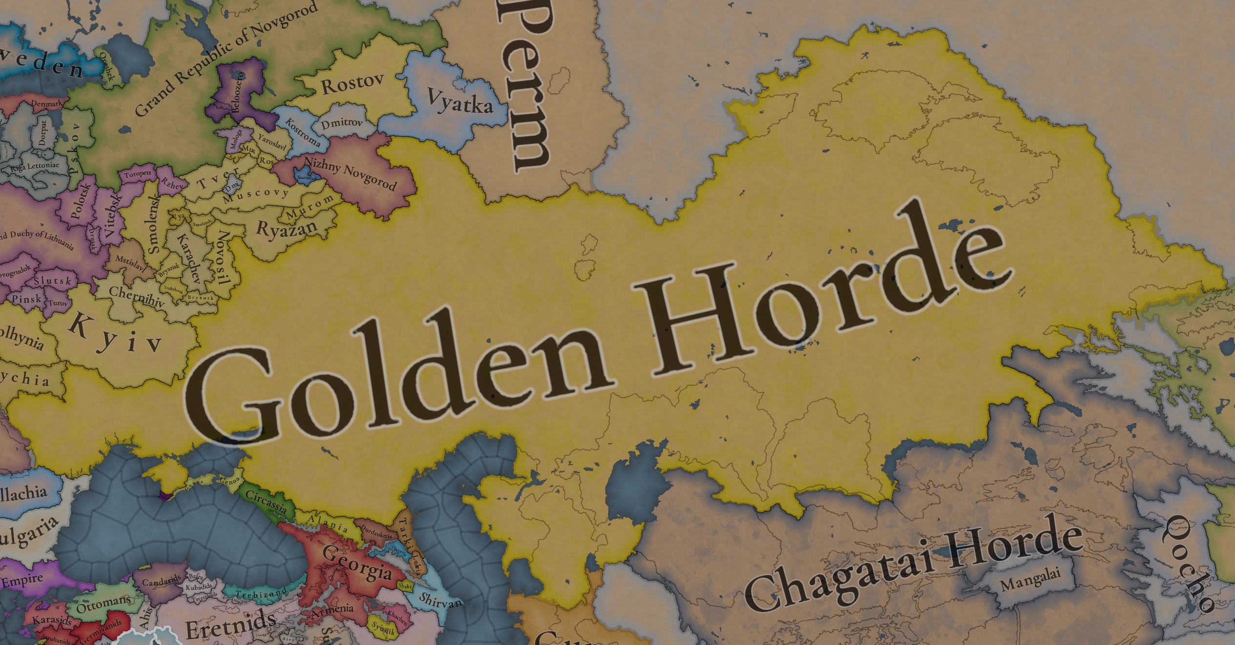
A glorious, Golden Horde! It is at its power peak, under the reign of Uzbeg Khan, so it's a much more menacing presence for its neighbors. However, it has its some internal issues that need to be managed, as you’ll notice in some of the maps, and in the future when we talk about the content for Hordes. The Golden Horde also heads its own IO, the Tatar Yoke, as shown in a previous Tinto Maps:

Tatar Yoke.jpg

We have already corrected the Ruthenian countries that are under the Horde’s Yoke, although we still have to correct the Russian principalities, which will be done in the corresponding Tinto Maps review. We’re also aware that we need to improve a bit the coloring of the IO, to mark not only the Golden Horde as the overlord of these countries, but also that Muscovy holds the title of the Grand Principality of Vladimir, which makes it the ‘enforcer’ of the Yoke. These fixes are also planned to be done in a few weeks.

Societies of Pops:
Societies of Pops.jpg

Societies of Pops 2.jpg .jpg

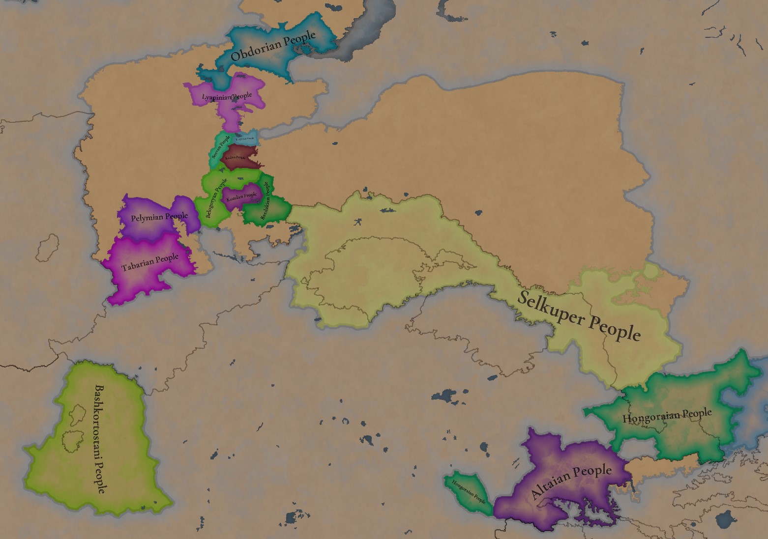
A bit up to the north, we have some Societies of Pops! This means that the territory of Western Siberia won’t be empty land, but will be populated by these people, which can be interacted with.

BTW, I’m not showing this week a dynasty map because, well, only the Borgijin dynasty rules over the lands of the Golden Horde, of course!


Locations:
Locations.jpg

Locations Western Siberia.jpg

Locations 3.jpg

Locations 4.jpg

Locations 5.jpg

Tons of locations today… You might notice that the density location is in a progression from west to east, from the most densely settled areas to the less settled ones. You may also notice that we’ve followed a design of ‘settler corridors’ in Western Siberia, setting those parts of the land that were habitable, usually on river valleys.

Provinces:
Provinces.jpg

Provinces 2.jpg


Areas:
Areas.jpg


Terrain:
Climate.jpg

Topography.jpg

Vegetation.jpg

The terrain is interesting here, as there are two main ecological areas. The first is the Steppes, Flatlands with Sparse and Grasslands vegetation, with either Cold Arid or Continental climates. And then we have the Siberian Arctics Forests, which are completely different, of course. On a note, the Urals were set as Hills, as they’re a quite settleable area, but we’ll probably make a review with your feedback, and add some mountains there.

Development:
Development.jpg

The whole region is not very developed, you might notice the difference with India, from last week’s Tinto Maps.

Harbors:
Harbors.jpg

There are some harbors in the Steppe region… In the Black Sea and Caspian Sea, of course! As usual, we’re open to feedback on this matter.

Cultures:
Cultures.jpg

Plenty of cultures! One note: Although we planned to work on the religious and cultural minorities of the region during the summer, we ended up not having enough time to add them. So what we’ll be doing today is showing the rough outline of ‘cultural spheres’, and then we’ll add the minorities during the review of the region. In that sense, feedback is very well received.

With that said the only note that needs to be made in terms of the cultural design is that we divided the Tatar cultural group into some differentiated regional cultures, being Crimean, Mishary, Kazani, and Astrakhani. We’re also aware that some of the cultures, as Mari and Chuvash, might be a bit displaced, as noted in the Russian Tinto Maps, so we’ll review and correct that with your feedback.


Religions:
Religions.jpg

Regarding Religions, the matter is a bit worse, as the big Sunni blob is just because the main religion of the Golden Horde is Islam, after the conversion of Uzbeg Khan, but that’s obviously incorrect. Also, as we have been able to forecast development time on how Pagan divisions will be during this autumn, we will make a comprehensive review of the region as well, to get a good distribution of ‘Shamanist’ Paganism, Tengrism, and Sunni Islam.

Raw Materials:
Raw Materials.jpg

Raw Materials 2.jpg

Raw Materials 3.jpg

Regarding the raw materials, the Steppes have plenty of Livestock and Horses, quite logically, although there are regions with some other goods. And up to the north, the main materials are Lumber and Fur. Apart from that, I want to mention the mineral hub in the Ural Mountains, with plenty of Copper, Iron, Gold, Lead, and Coal. That makes it a very mid and late-game interesting spot, and playing as Muscovy/Russia, I’ll tell you that you definitely want to expand into that region, as it will fulfill some of your material needs by that time.

Markets:
Markets.jpg

Markets! Big region, with lots of markets, although you may noticed that we changed the coloring of the locations that have 0% market access, which is the case in several areas. In any case, the market centers are Kaffa, Astrakhan, Saray-Jük, Kunya Urgench, Samarkand, Almaty, and Chimgi Tura. BTW, these names are much easier to notice in the game’s UI, as they’re beside the market centers:

Markets 2.jpg


Population:
Population.jpg

This week we’re showing only the country population mapmode, as there are some location numbers here and there which are failing, due to the already known issue with our pop editor (and which are on the way to be fixed). In any case, the whole population of the region is around 6.5-7M, of which around 6.3M are part of the Golden Horde. As I said, it’s a menacing country…

And that’s all for today! This is going to be my last Tinto Maps in a while, as I’ll be on vacation for 3 weeks during October (you might have noticed that I didn’t have any during summer), so one of the Content Designers in the team, @Roger Corominas , will step in and be in charge of the next 4 Tinto Maps. It’s in good hands, as Roger is an Experienced CD, who has been working and focused on Project Caesar for more than 3 years, at this point (this is why you might not know him from EU4, as other CDs in our team). In any case, he will be starting with the regions of Xinjiang, mostly ruled by the Chagatai Khanate, and Tibet.

I’ll keep reading and answering you during next week, and then I’ll be back in a month from now. See you!
 
  • 145Like
  • 48Love
  • 4
  • 3
  • 1Haha
Reactions:
I keep seeing people on here advocating for turbo-Balkanizing the Golden Horde... I'm not convinced that more tags, more balkanization = more historically accurate = better. Are you all sure that 1. we have enough sources for all the lesser hordes to justify their inclusion as sovereign states, and 2. it would benefit gameplay?


For some we do, tentatively. As Ispil has mentioned, there are 0 sources from the hordes themselves, while many which we do have are from Timur, whose dealings were mostly with the Eastern portion of the Golden Horde.

As for gameplay, I talked about this in the Persia thread before. Lesser tags serve to add flavour and gameplay for the greater. If they didn't, we could pack it up, consolidate France, UK, the HRE, etc, and call it a day. The fact that isn't the case tells me that the devs seem to agree, as long as it is historical.


Last edited:
  • 1Like
Reactions:
The old locations weren't the best for that region so the feedback isn't exact. Do keep in mind that places like Atrat and Alyshevo were founded in the 17th century, and while there may have been Erzya there before that, the foundation of those specific settlements is due to further migration movements related to the activities of the Russian empire almost 300 years after the game start. So I would be cautious on assigning the culture based on that information alone.
This is to my knowledge all the Mordovian burial grounds of the 13th to 14th centuries
View attachment 1262233

However this map does show a Mordovian burial ground somewhere around Batyrevo. But I still wouldn't call it definitive that this area was majority Erzya, especially when in the preceding era it was part of the Volga Bulgar state and more importantly due to how little archaeological material there is from the Mordvins in this area.
View attachment 1262234
In fact this area seems pretty sparsely populated overall at this time. I would make it Chuvash majority since it better aligns with the Sura border with Erzya, with maybe some Erzya minorities instead.

As for Nizhny Novgorod, I agree it should be pretty much just Russian, there was barely any Erzya activity there despite the Obran Osh legend archaeologically speaking. Perhaps it was a fort with no further settlement around it. However, on the first map Nizhny Novgorod is located west of where you place it, but ultimately the updated locations should be used so it doesn't really matter.
View attachment 1262236

On the new map Nizhny Novgorod is placed where Gorodets is supposed to be and Meschersk is where Nizhny Novgorod is supposed to be, although this doesn't really change the borders that much. Gorodets and Unzha should be Russian majority, but with Mari minorities. Or going off of your map perhaps Merya minorities. Although Gorodets was said to have been established on Mari lands but this could well be a case of conflating the two which is not unheard of, or just the proximity of Mari people to the area.
View attachment 1262238
On the mouth of Sura one can spot some Mari, which is substantiated by archaeological evidence.
View attachment 1262239
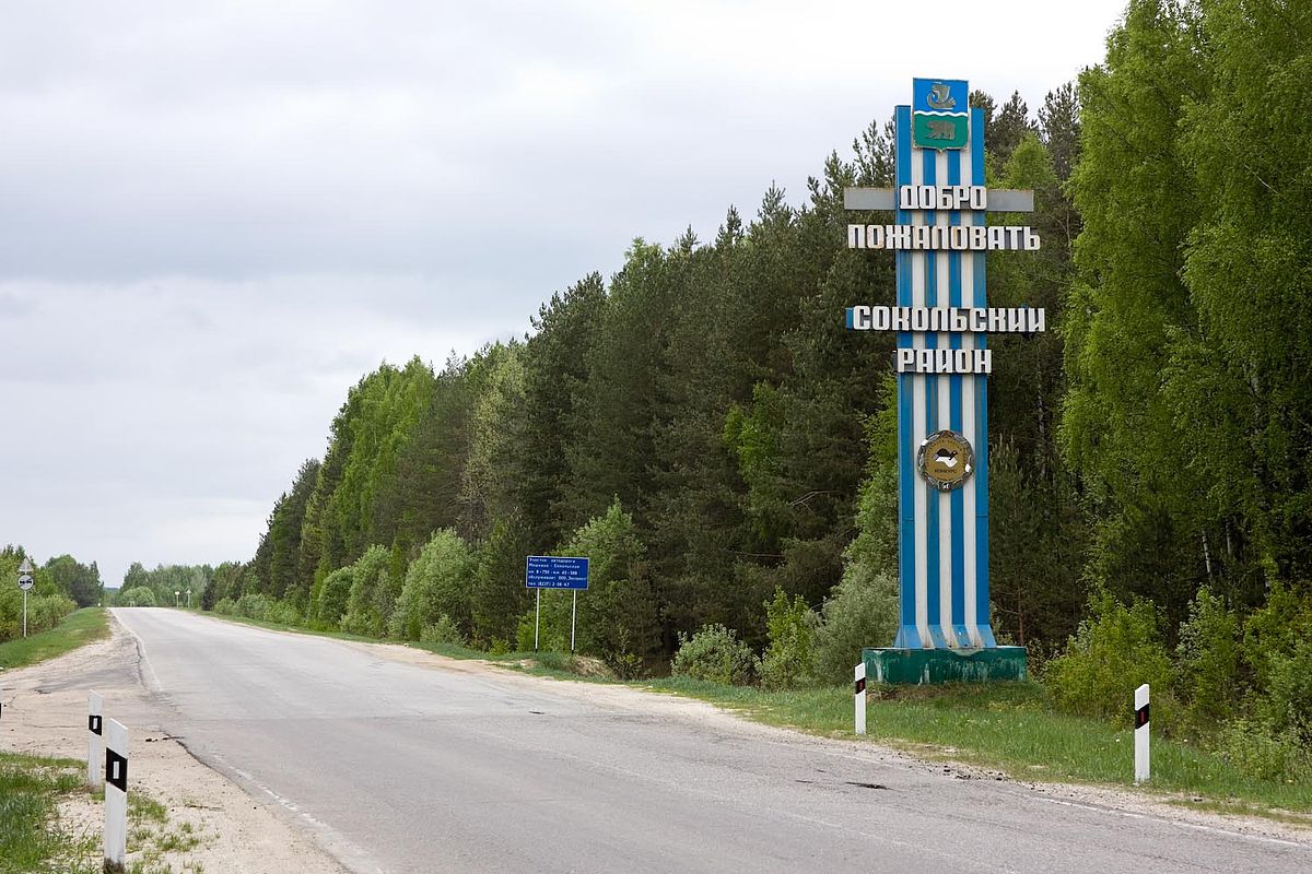
I think the location of Korenevo could still be Mari/Merya as the closest settlement Sokolsky wasn't founded until the 1400s

View attachment 1262274
Summing all that up how about this?
Hmm, good points. I think I will agree with your proposal now.

So, does this mean that Meshersk should be renamed Nizhny Novgorod? Maybe the location should be edited to be more centered around the Novgorod location, though.

However, another proposal is to use Dalneye Konstantinovo as it will look like a Nizhegorodsky uezd (I have tried adding rivers as I see them going). It is ahistorical, but at least real.
1741350027055.jpeg
1741350850005.png


Another comment is that map
On the new map Nizhny Novgorod is placed where Gorodets is supposed to be and Meschersk is where Nizhny Novgorod is supposed to be, although this doesn't really change the borders that much. Gorodets and Unzha should be Russian majority, but with Mari minorities. Or going off of your map perhaps Merya minorities. Although Gorodets was said to have been established on Mari lands but this could well be a case of conflating the two which is not unheard of, or just the proximity of Mari people to the area.
1741346858710.png
Shows that the lands around the Vokhma location are a border of cultures. Perhaps it should be mixed Mari-Komi.

Nevertheless, awesome!!
 
  • 1
  • 1Like
Reactions:


For some we do, tentatively. As Ispil has mentioned, there are 0 sources from the hordes themselves, while many which we do have are from Timur, whose dealings were mostly with the Eastern portion of the Golden Horde.

As for gameplay, I talked about this in the Persia thread before. Lesser tags serve to add flavour and gameplay for the greater. If they didn't, we could pack it up, consolidate France, UK, the HRE, etc, and call it a day. The fact that isn't the case tells me that the devs seem to agree, as long as it is historical.


However Timur lived later, after the Horde imploded considerably more than how disunited it was in 1337.
 
  • 1
Reactions:
Hmm, good points. I think I will agree with your proposal now.

So, does this mean that Meshersk should be renamed Nizhny Novgorod? Maybe the location should be edited to be more centered around the Novgorod location, though.

However, another proposal is to use Dalneye Konstantinovo as it will look like a Nizhegorodsky uezd (I have tried adding rivers as I see them going). It is ahistorical, but at least real.
View attachment 1262311View attachment 1262312

Another comment is that map

Shows that the lands around the Vokhma location are a border of cultures. Perhaps it should be mixed Mari-Komi.

Nevertheless, awesome!!
I think you could fit in a Nizhny Novgorod location here.
1741351197328.png
 
  • 3
Reactions:
The old locations weren't the best for that region so the feedback isn't exact. Do keep in mind that places like Atrat and Alyshevo were founded in the 17th century, and while there may have been Erzya there before that, the foundation of those specific settlements is due to further migration movements related to the activities of the Russian empire almost 300 years after the game start. So I would be cautious on assigning the culture based on that information alone.

This map illustrates the 16th century migrations of the Mordvins
View attachment 1262285
https://dep_anatom.pnzgu.ru/files/dep_anatom.pnzgu.ru/conference/povolzhskie_finny_i_ih_sosedi_v_drevnosti_i_srednie_veka_2016.pdf
This is to my knowledge all the Mordovian burial grounds of the 13th to 14th centuries
View attachment 1262233

However this map does show a Mordovian burial ground somewhere around Batyrevo. But I still wouldn't call it definitive that this area was majority Erzya, especially when in the preceding era it was part of the Volga Bulgar state and more importantly due to how little archaeological material there is from the Mordvins in this area.
View attachment 1262234
In fact this area seems pretty sparsely populated overall at this time. I would make it Chuvash majority since it better aligns with the Sura border with Erzya, with maybe some Erzya minorities instead.

As for Nizhny Novgorod, I agree it should be pretty much just Russian, there was barely any Erzya activity there despite the Obran Osh legend archaeologically speaking. Perhaps it was a fort with no further settlement around it. However, on the first map Nizhny Novgorod is located west of where you place it, but ultimately the updated locations should be used so it doesn't really matter.
View attachment 1262236

On the new map Nizhny Novgorod is placed where Gorodets is supposed to be and Meschersk is where Nizhny Novgorod is supposed to be, although this doesn't really change the borders that much. Gorodets and Unzha should be Russian majority, but with Mari minorities. Or going off of your map perhaps Merya minorities. Although Gorodets was said to have been established on Mari lands but this could well be a case of conflating the two which is not unheard of, or just the proximity of Mari people to the area.
View attachment 1262238
On the mouth of Sura one can spot some Mari, which is substantiated by archaeological evidence.
View attachment 1262239
I think the location of Korenevo could still be Mari/Merya as the closest settlement Sokolsky wasn't founded until the 1400s

View attachment 1262274
Summing all that up how about this?
Btw doesn't the first map say that the Mordvin burial grounds around Samara are caused by migration and dated XII-XV century, so they can be outside the game perspective? Because I do find those Moksha pockets near Samara questionable.
 
Last edited:
However Timur lived later, after the Horde imploded considerably more than how disunited it was in 1337.


True. Conversely however, we have no sources which would talk about Özbeg Khan's reforms in detail. Had they integrated Shiban and Orda Ulus into their administrative framework, or simply tightened the leash on them as subjects? We simply do not know, and would be wrong to assume.

What we do know, is that they existed before Özbeg, and they existed after Özbeg, which is enough for me, without evidence to point otherwise.


Last edited:
Btw doesn't the first map say that the Mordvin burial grounds around Samara are caused by migration and dated XII-XV century, so they can be outside the game perspective? Because I do find those Mokha pockets near Samara questionable.
Machine translated from pages 208-209.
Mordvin burial grounds appeared in the Samara Volga region in the 14th century: the Erzya burial ground of Barbashina Polyana; the Moksha burial ground of Muransky; the Erzya-Moksha burial ground of Usinsky 2. The Moksha burial ground of Atkarsky is known in the Saratov Volga region (Gazimzyanov, 1995, pp. 21–22). Mordvin syulgams were found during excavations of the Selitrenny settlement (the city of Sarai) (Zeleneyev, 1993). Moreover, these finds indicate the presence of people of Mordvin nationality among the city’s inhabitants, and not their appearance here as a result of trade.
Of interest is the cultural complex of Golden Horde settlements discovered south of Saratov in the Ukek region. One of them is the Khmelevskoye 1 settlement (Nedashkovsky, 2000). Here, too, the predominant cultural complex can be characterized as Golden Horde, formed in the 14th century. It is based on Golden Horde red clay ceramics of various types. But among this ceramics there are also Russian pottery vessels with an admixture of gravel and sand, which can be dated to the 14th–15th centuries, and Mordvin dishes with an admixture of chamotte, which apparently dates back to the same time (Nedashkovsky, 2000, p. 3). At the same time, Russian and Mordvin ceramics are sometimes concentrated in closed complexes, for example, in pit 4 of excavation 1 of 1999 in the Khmelevsky settlement, although the overwhelming majority of ceramics from this pit are Golden Horde red clay (Nedashkovsky, 1999, p. 10).
Russian and Mordvin ceramics are found in the materials from the excavations of the settlements of Shirokiy Buerak, Bagayevskoye, and Kolotov Buerak, with an absolute predominance of red clay Golden Horde ceramics (Nedashkovsky, 2002, p. 2). The Golden Horde settlements adjacent to Ukek were inhabited by a sedentary agricultural population whose main occupation was crop production, primarily growing millet. Livestock farming was apparently of an auxiliary nature. The herd consisted mainly of cattle and small ruminants. Pig bones were found in small quantities only at the settlement of Shirokiy Buerak, which is consistent with the presence of Russian and Mordvin populations living in these settlements (Nedashkovsky, 2002, pp. 194–198).
The reason for the significant increase in the Mordvin ethnic territory was the political stability in the Golden Horde in the first half of the 14th century. The safety of the state's subjects, regardless of their ethnicity, allowed the Mordvins to develop the steppe and forest-steppe regions of the Lower Volga region, which were convenient for arable farming.
The last major campaign against the Mordvins after Batu Khan dates back to 1288 (Documents..., 1940, p. 123). After that, the Mordvins did not participate in major wars for almost 100 years, which undoubtedly also contributed to the economic and ethnic development of the people. At the same time, the penetration of foreign ethnic populations into the Mordvin lands proper in the Golden Horde period increases.
In particular, the migration of the Turks is indicated by the presence of male burials in Mordvin burial grounds with the remains of a horse, a full set of weapons and equipment of a rider of nomadic appearance. Such monuments include the Krasnoye 1 burial ground excavated by V.N. Martyanov in the Tesha River basin in the area of the modern city of Arzamas (Zeleneyev, 2002, p. 210). In the 14th century, if not earlier, the resettlement of Russians in the Mordvin lands resumed. Undoubtedly, Shaverskoye 3 in Primokshanye and Poretskoye in Posurye belong to the Russian settlements. At the same time, ceramics were found here that can be identified as Mordvin, and in the Shaverskoye settlement there are also Mordvin syulgams. This fact indicates the possible coexistence of Mordvins and Russians in rural settlements in the 14th–15th centuries.
At the beginning of the 15th century, the Mordvins continued to be part of the Ulus of Jochi. This is noted in the Russian chronicle for 1408, when describing a special operation by the Moscow prince Vasily Dmitrievich to capture the wife of the Nizhny Novgorod prince Semyon: "And they went to the Mordvins, and arrived in the Tatar land (highlighted - Yu. Z.), in a place called Tsibirtsa ..." (Documents ..., 1940, p. 129). Tsibirtsa is the Cheberchinka River or the village of Cheberchino in the modern Dubensky district of Mordovia (Poluboyarinova, 1978, p. 14).
In the next 40 years of the 15th century, the Horde was gradually displaced from the Mordvin lands by the Moscow principality and part of them came under Moscow jurisdiction. In connection with this, the military-political orientation of the Mordvins also changes. Now they participate in wars not on the side of the Horde and the post-Horde states, but on the side of Moscow. Thus, in 1444, the Mordvins, as part of the Moscow troops, participate in the campaign against the troops of Tsarevich Mustafa near Ryazan. In response to this, the following year, "the Tatars fought the Mordvins ..." (Documents ..., 1940, pp. 129-130).
From the turn of the 1430s to 1440s, the interests of two states fighting for the Golden Horde inheritance clashed in the Mordvin lands: the Kazan Khanate and the Moscow Principality. Until 1552, the Mordvins were part of both of these states. It is possible that its southern part was part of the Great Horde until 1502, and part was completely independent.
Maybe there should be some more Cumans and Russians interspersed among the Mordvins judging by this.
 
Last edited:
  • 1
Reactions:
According to Wikipedia Mubarak Khoja Khan of Orda-Ezhen declared independence in 1337
Maybe the eastern areas of Shiban Ulus, Taibuga Yurt and Orda-Ezhen could be represented, the smaller uluses seem a bit less stable.
According to Wikipedia he also was independent in 1366-68 and in 1344-74.

Which is to say, don't trust Wikipedia on this stuff. They can't even figure out which horde is which and now have three dedicated pages to the subject and none of them get it right.


True. Conversely however, we have no sources which would talk about Özbeg Khan's reforms in detail. Had they integrated Shiban and Orda Ulus into their administrative framework, or simply tightened the leash on them as subjects? We simply do not know, and would be wrong to assume.

What we do know, is that they existed before Özbeg, and they existed after Özbeg, which is enough for me, without evidence to point otherwise.


Honestly I'm becoming rapidly disinclined to have them as subjects; from that post I made a few pages back, they were internal administrative divisions that were appointed, not hereditary.
 
  • 1
  • 1
Reactions:
According to Wikipedia he also was independent in 1366-68 and in 1344-74.

Which is to say, don't trust Wikipedia on this stuff. They can't even figure out which horde is which and now have three dedicated pages to the subject and none of them get it right.

Honestly I'm becoming rapidly disinclined to have them as subjects; from that post I made a few pages back, they were internal administrative divisions that were appointed, not hereditary.
Yeah, digging into this reveals that the researchers themselves were a bit confused.
However, the answer is more than obvious and is connected with the date of minting of Mubarak Khoja's coins. It is very important to know the real and reliable dates, but 728, 729 or 738, 739 proposed by Savelyev are not such. Savelyev was obsessed with the idea of establishing the minting date between 720 and 745, i.e., in his opinion, the time of Mubarak Khoja's reign, which is approximately the time between 720 and 730. Savelyev's hypothesis entered the scientific literature so deeply that Yakubovsky, who saw two coins of Mubarak Khoja with a completely obvious date of 768 AH, could not believe his eyes and interpreted it as 728, correcting the Arabic numeral 6 (٦) to 2 (٢) [11, p. 311: note 4]. In addition to the coins of Savelyev and Markov, we currently have four more coins in our possession. There can be no doubt about the dates 768 (٧٦٨) and 769 (٧٦٩). This indisputable numismatic evidence regarding the coins of Mubarak Khoja allows us to give a different interpretation to the whole chain of events and to eradicate many misconceptions in our historical knowledge [21]. First of all, Mubarak Khoja minted coins in 768 and 769 AH (07.09.1366–15.08.1368), that is, forty years later than the date established to date by most researchers [22]. Therefore, Mubarak Khoja’s attempts to gain independence in Sygnak, the capital of the Blue Horde, took place during the bulqaq , the great unrest that followed the death of Khan Berdibek in 1359/60.
 
Yeah, I think this works with my idea of the "Great Troubles" being a disaster that involves spitting off a lot of independent states to vie for the throne much like the Red Turban Rebellion.
I think lots of large tags need a mechanic where they can gain in the short term at the expense of contributing to a measure that, if it hits a certain level, will split off large chunks of the country into vassals. This would be to simulate that many polities (I don't know why it didn't seem to happen to any European ones) suffered from growing autonomy of regional governorships, including many that were supposed to be centrally appointed.
Then if one had a large number of vassals, a mechanic would kick in where one could gain in the short term he expense of contributing to a measure that, if it hits a certain level, will cause most vassals to gain independence.

Obviously such mechanics ought to have local variants for the steppes versus India versus China versus Iran.
 
It seems Shandinskaya culture is a descendant of Srostki culture, and the area doesn't actually correspond to the historical Shor area that well, so I made the area Teleut instead. Added Kumandins to their homeland. Implemented some of the changes proposed.
1741458917079.png
 
  • 2Like
  • 1
Reactions:
Northern part of Zyriane should belong to Pechora culture
The Pechora tribe was likely located on the Lower Pechora, as the Middle and Upper Pechora were inhabited by Komi people.
1741465993612.png

But it's unknown whether or not the Pechora tribe would have still existed in the 14th century or not. If they did they're probably associated with the Ortinsky fort.
A new stage in the development of the region under study in the first quarter of the 2nd millennium AD begins with the penetration of the Novgorodians. At this time, the first written evidence appears, undoubtedly concerning the Pechora region. It is very fragmentary and scanty. From the opening pages of Russian chronicles [27], one can learn that the "Pechera" was among the peoples paying tribute to Rus. In the narrative of the Novgorodian Gyurata Rogovich (1096), the "Pechera" are called people paying tribute to Novgorod. It also tells about the "Yugra" people, who possibly lived in the Pechora region, and mentions the "Samoyad" (Nenets), neighboring the Yugra. This mention of the "Samoyad" obviously testifies to the beginning of the process of their penetration into the Bolshezemelskaya tundra, which led to a change in the aboriginal population in the region [19]. Unfortunately, it is almost impossible to establish the geographical location of these peoples from the chronicle data, and in the case of the Pechora, their ethnicity. Subsequently, written sources mention Pechora as a volost subordinated to Veliky Novgorod. Sources from the late 13th - early 14th centuries, related to the grand ducal jurisdiction, the so-called "Pechora acts", include "trade patents" of "Zhile and companions", Mikhail, Matthew and Andrei Fryazin for marine and bird trade, where Pechora is mentioned as a region or volost, and the inhabitants are called Pecherians, without any ethnic connotation [28]. The last mention of the Pechora people dates back to 1481. From the moment of the construction of the Pustozersky town on the Lower Pechora (1499), the Pechora volost became Pustozerskaya and began to a new stage of development of the region is taking place in the general context of the state policy of the eastern “growth” of Russia.

It should be noted that, despite the extreme scarcity of messages from the first Russian chronicle collections, most Russian researchers have no doubts about the hypothesis that the Lower Pechora region was fairly well known to the population of Rus' by the beginning of the 12th century. A certain clarity to the picture of the history of the development of the Northern Pechora region in the first half of the 2nd millennium AD is brought by a few archaeological sources, including materials from the Ortinsky settlement (11th-12th centuries), the Gnilka sanctuary of the 6th-11th centuries, the Novy Bor 1-4 settlement complexes (13th-15th centuries), and the Pusto-Zerskoye settlement (16th-20th centuries). Among the random collections from the Bolshezemelskaya tundra, finds of two axes (11th-12th and 14th-15th centuries) are known, as well as fragments of unadorned circular pottery. Axe of the 11th-12th centuries. was found in the vicinity of the city of Naryan-Mar, and another - on Gorodetskoye Lake. Fragments of circular dishes, together with an armor-piercing arrowhead from the 11th-14th centuries, come from collections at the Pustozerskaya 3/5 [29, 30] and Naryan-mars-kaya 5/14 [31] sites. Obviously, these sites belong to the Pecherskaya volost mentioned in written sources of the 14th century, which was the extreme northeastern outpost of the Russian state.

It also seems that the Lower Pechora was inhabited by people from the Lower Ob culture which is associated with Ugrians and Samoyeds.
Thus, the analysis of the available sources from the European tundra, the Lower Ob region and the Yamal Peninsula allows us to conclude that in the early Middle Ages, the continental and coastal regions of the tundra zone of northeastern Europe, including the Pechora region, were inhabited by groups whose material culture clearly shows similarities with the population of the Ob-Yamal north (ancient Ugric or Samoyedic). This similarity makes it possible to assume that, at least in the second half of the 1st millennium AD, the subarctic and arctic regions of the European sector of Eurasia were inhabited by closely related groups whose origins were largely associated with the regions lying to the east of the Ural ridge.
 
Last edited:
I think one of the problems is that you misunderstand what "nomadic order" means. Regarding the late Middle Ages and early Modern times, according to wikipedia, nomads had a feudal mode of production. That is, exactly the same as the rest of Europe, but with significant features. These features consisted in the fact that people were not particularly divided into social classes and nomadic cities (settlement zones) were very far from each other with low population density, which subsequently led to the fact that the horde could not begin the transition to a capitalist mode of production.

This means that "industrialization" (or the accumulation of population density) can be a mechanics for reform from a nomadic system to a nomadic monarchy. A nomadic horde is originally a country based on an army. In case of internal strife, when the army is defeated, the ulus or nomadic emirate goes entirely to the winner, and upon the death of the ruler or defeat in an external war, all territories break up into the original uluses. During the transition to the nomad monarchy, the absorbed uluses are annexed. By about the 15th century, all nomadic systems could be reformed into nomadic monarchies and begin to catch up with other countries in development. Such states will still be part of the international organization of the Golden Horde, but in fact they will become independent.

So, let's look at the maps that I have already shown.
post-1657-1177398664.jpg

2lEYvmZPJJ4.jpg

These are 19th-20th century maps, as the name suggests. They show Kazakhstani tribes and their names. Another map shows the dominant genetic marker. These names can be found on the Internet. We do this, read the information and make a map, also of the 19th and 20th centuries.…
Казахи.png

The map indicates the peoples/cultures from which the Kazakh clans originated. It's funny that not all Naymans are descended from Naymans. By the way, the Kereites used to call themselves Naimans for some reason, unfortunately, the information about this was adopted by many scientists, which is why a lot of mistakes were made in many sources. Well, do you see the big picture? Probably not. Let's highlight in color the cultures that originate from the Mongolian groups.…
Kazak.png

Oh my God! We seem to see a familiar picture. These are our uluses! Let me remind you that this map is from the 19th to the 20th century, not the 14th century. We can draw several conclusions from this. First of all, why didn't they migrate into each other and mix up??? For comparison, a map of Europe. We can see the Viking migration on it. The way Berber nomads genetically displaced everyone from North Africa. The Russian conquest of Siberia. And the Kazakhs could not assimilate the Kipchaks! It was a surprise to me personally.
европа.png

So we don't imagine nomadism quite the way it really was. There were fiefs in the Golden Horde, they were just much larger than in Europe, and nomadism was mainly within the borders of these territories. Secondly, a ulus is not just some kind of administrative unit, but a separate tribe, with its own territory, chief and tax collection system (the Supreme Khan gave a label to the reign for this). And it looks like they've been around since the beginning of the Golden Horde, they've never disappeared, and they've never reappeared. They were simply absorbed by other uluses when the time of "independence" came, in quotation marks. Oh no, so you were right, I really did not display the uluses correctly, there should be one more in this part of the map.

Uluses can indeed be displayed as tribal societies within the golden Horde, since they are tied more to the population than to the territory, but I would not do this, since Sufi orders and small tribal groups should be on the extraterritorial layer of the map. The genetic analysis of clans cannot tell about the origin of closely related genetic groups, so we cannot say for sure whether the inhabitants of the Shiban ulus and Mangyshlak were from the same tribe or from different, but neighboring ones. The Burjans (marked in light green) historically arrived at this place around the first half of the 14th century, which means that they most likely still have elements of a semi-independent political formation, which means they should be represented in the game as a separate vassal state. Gentlemen, find information about him to present him in the most appropriate way. This thing is not a ulus, so I don't know anything about it.

The R1 and Q genes are most common among the Baraba Tatars (Shibir ulus), most likely they are Kipchaks. If Desht-i-Kipchak ulus already existed, then Ibir and Sibir ulus should then be one whole Ibir-Sibir ulus (both had Kereits as the dominant culture). This means that it was in Shibera that the local leaders ruled. But I could be wrong, because I still can't see the whole picture. At all time intervals. It is clear who was on the Volga River, those after whom all the others were named are Tatars. In Kazan and on the Sylva River (Korel Ulus), the J2 gene dominates. It must be... it can't be, Teleutes? Hardly, then who else can the J2 gene relate to? Well, in the West there is a lack of genetic material, the Lithuanians almost cut out everyone, scientists say that there are O and E genes that are not found in Kazakhstan, which means that some Polovtsian cultural groups could dominate there. In general, this part requires additional study and recheck.

And Kartan ulus has historically become part of the Crimean ulus, not Batu ulus. This could only happen at one time, during the formation of Mamai's Horde. That is, in the second half of the 14th century, which means that at the time of the start of the game, this ulus may still exist. And the Mautsi ulus should be there too, because it disappears around the same time. And where was he, if the Crimean ulus is located there? Oh no, the data is diverging again. Perhaps I will continue to make a map of the uluses until Uzbek Khan's reforms, where they can all be displayed.

By the way, information about the "Wild Field" appears in the annals at the end of the 14th century. Most likely because of the outbreak of bubonic plague and numerous local wars (Mamai, Timur, Lithuanians, everyone came there to fight). The plague did not enter the lands of the Russian principalities due to the sparsely populated regions of the Okraina and Chervlenyi Yar. The term "Wild field" has spread to these regions already in modern times, by not very smart researchers who considered that the fertile land of Zaporizhia was not needed by anyone for more than 100 years (Please do not tell me that this is historical. This is nonsense! Why would the Tatars have been clearing this area of people for 100 years in a row? For what? Think for yourself before giving me stupid sources. Just give me a cross if you believe in this nonsense). I will say even more, the "Wild Field" had one ruler with a name, his name was Skider (son of Mansur-Kiyat and grandson of Mamai, as well as brother of Oleksa. Oleksa ruled the principality Glinskoe), it is quite possible that "Wild Field" could be the name of the state, because Skider went with his army to the west and conquered the lands there, and then swore allegiance to Lithuania. I cannot trace the inheritance of this political entity earlier than the Mamaev Horde. But I do not exclude the possibility that there really could be some kind of political entity in Sharukan's place, since during the game period there are no recorded possessions of the Mankerman ulus in this place. In theory, there should be a Mautsi ulus there, which was dissolved... or maybe it's not dissolved, and then this is the Mautsi ulus, just what I was looking for. This thing could carry the ideals of the Cossacks long before the appearance of the Cossacks.

Perhaps one of the following maps should definitely be made about the regions of settlement and religion, they are interconnected. This map should be important because I have linked the uluses to such areas. Under Uzbek Khan, the cities were flooded with various Muslim Sufi orders, mainly from Iran, who preached Islamic teachings. That is why the transition to Islam was relatively quick. And there are problems with studying there too. Different researchers could not agree on the unity of terms again, and everyone introduces their own, as with the names of the uluses. For this reason, I will not mark the location of these orders on the map until I have dealt with the uluses. They write that initially there were 19 uluses under Batu. There were 23 uluses before Uzbek Khan. Under Uzbek Khan, only 17 uluses were loyal to him (the remaining 6 belonged to the Jochids?). Iskhakov and Izmailov identified 37 main ruling clans. And there could be 92 tribes in total. I will aim to mark exactly 37 territories with ruling clans, because they had some real power. You can express your indignation due to the fact that we do not have unambiguously interpreted sources, but this will not stop me, I will choose the location options that are as least conflicting as possible and most widely cover the events that took place in "Great Troubles". In my opinion, a compromise of historicity and playability is better than a correct depiction of all historical nuances. Because the game will not be able to create a good system for the disintegration of the Golden Horde with a simplified model.

19.png

23.png

37.png
92.png


4908a738-56db-4214-a26a-f8104ac4fa85.jpg

b8cf9b5a-b466-4922-8d91-8dd9235d7c2c.jpg

ef262fda-1fc4-4081-bdfb-54fba4b49ef6.jpg

b241fb64-7498-463f-9d83-a34f9e2ed472.jpg
 
Last edited:
  • 4
Reactions:
It seems Shandinskaya culture is a descendant of Srostki culture, and the area doesn't actually correspond to the historical Shor area that well, so I made the area Teleut instead. Added Kumandins to their homeland. Implemented some of the changes proposed.
View attachment 1262937
With the exception of Central Asia (there weren't that many Naimans), this is a very good map. It really fits in with my sources and helps me to better perceive information.
 
With the exception of Central Asia (there weren't that many Naimans), this is a very good map. It really fits in with my sources and helps me to better perceive information.
Judging by the information we have there really were that many Naimans, and they're playing double time for the Kushchi as well.
The exceptionally great ethnic diversity of the yurt granted to Shiban is also indicated by data on the tribal composition of the population of Eastern Desht in the 15th–16th centuries [Sultanov, 1982, pp. 7–51]. Apparently, Shiban was given a more or less representative part of the army that was under his command on the campaign to the west, although, of course, we have no documents that tell us why the main ethnic units in the omaks ended up in this role in the middle of the 13th century and what other, less significant tribal units were connected to them at that time. But subsequently, the presence of the aforementioned omaks in that particularly close-knit group of Uzbeks, which is called “shibanlig” in Turkic texts and “shibanian” in Persian texts is noted by almost all chronicles. In addition, their descendants (primarily Naimans and Kushchis) are mentioned more often than others in the immediate circle of the Shibanids. Let us cite the most striking examples. In the list of participants in the election of Abu-l-Khair as khan (approximately seventy names of sultans, oglans, seyids and leaders of two dozen different tribes), every fifth is a Kushchi or Naiman [MIKH, 1969, pp. 143-144]. In the Nusrat-nama, whose author is considered to be Sheibani Khan, many merits of the Kushchis, who were with the Shibanids since the time of the founder of the dynasty, are especially noted [MIKH, 1969, pp. 19-20]. Being, in fact, in the position of regents [Akhmedov, 1965, p. 100], they always remained loyal companions of their protégés. The names of the kushchi are also found in the performance of such high court positions as divans and ichki [Akhmedov, 1965, pp. 100-101]. In almost all the praises of the beks, who diligently "chopped with sabers" in the large and small wars of the Shibanids of the 15th-16th centuries, the names of the Naiman leaders are found. The large number of Naimans in the Uzbek ulus is partly illustrated by the following detail from the "Sheibani-name" of Muhammad Salih: the Naimans of Kanbar-biy (700 horsemen) made up almost half of the left wing of the native Uzbek army ("shibanlig") in the battle with the Mughals in 1503 [Sultanov, 1982, p. 10].
Pages 101-102
 
Last edited:
  • 1
Reactions:
Khwarezm I don't know so much about, perhaps it still had it's own identity at this time.
I haven't been able to find sources that make clear statements about cultural makeup of post-Mongol Khwarazm in terms of percentages or majorities, but it seems highly likely that there should be at least some elements of the pre-Mongol Khwarazmian culture existing in the urban areas alongside newer cultures, maybe even as a significant percentage, and that Khwarazm may have seemingly served as something of a cultural melting pot. It's important to note that, in contrast to many regions covered on your map and in this Tinto Maps, the Khwarazmian oasis both before and after the Mongols was highly urbanized with significant local cultural output and significant connections to other regions and influences, and even after the devastations of the conquest the major cities (or at least Urgench) were quick to rebound as urban trading centers. That's not to say that there weren't signficant changes as a result of the Mongol conquest - new regional connections and influences, new rulers, new migrations, general upheaval and reconfiguration as a result of war and destruction, etc - but it's going to result in different cultural trends than in steppe areas with a different way of life.

After the Mongol devastations the town [Urgench] was so speedily restored that the cultural traditions of pre-Mongol times suffered no interruption. The school of speculative theologians, the Muʿtazilites, which had been founded in Khwarazm at the beginning of the twelfth, subsisted till the end of the fourteenth century. Already in the twelfth century there existed some Turkish literature of pious Islamic inspiration in Khwarazm and along the lower course of the Sir-Darya. Similarly important for the development of Turkish literature was the role of these regions when they formed part of the khanate of the Golden Horde. The writers of this region preceded those of the Chaghatay khanate, although the literary Turkish language of these parts was later comprised under the term "Chaghatay". Khwarazm attracted scholars and artists who subsequently became conspicuous in the development of art and science in Timur's empire. The magnificent buildings of the early fourteenth century, which still survive among the ruins of Old Urganch, must have influenced the constructions of Timur, as well as those of the Golden Horde, as for example in Bulghar (on the Volga). (Barthold 1956 "A Short History of Turkestan," in Four Studies on the History of Central Asia, vol. 1, pg 55-56.)
In the 13th-14th centuries, the Khorezm cities again became centers of science, literature, and theological scholarship. Representatives of the spiritual life of the Khorezm culture—poets—actively participated in the cultural life of the Golden Horde.... Turkic dialects became widespread in the literature of the Golden Horde, among which the Kipchak language occupied a special place. Along with Turkic literature, elements of Persian literature also developed in Khorezm and the Golden Horde. Imitation of the best creations of Persian poetry is observed in the above-mentioned poem of Khorezmi, where several ghazals are written in Farsi.... A characteristic phenomenon for Khorezm in the second half of the 14th century is the desire for cultural and political autonomy. (Kydyrniazov 1989, Материальная культура городов Хорезма в XIII-XIV веках. pg 137. Translated with Google Translate.)

The source I really want to look at for this is:

Вактурская Н.Н. О средневековых городах Хорезма. Полевые исследования Хорезмской экспедиции в 1958-1961 гг. Т. II. Памятники средневекового времени. Этнографические работы. МХЭ. Вып. 7. М.: 1963. (Vakturskaya, N. N. 1963. O srednevekovykh gorodakh Khorezma. Materialy Khorezmskoy Ekspeditsii. Vyp. 7, Polevye issledovaniya Khorezmskoy ekspeditsii v 1958 — 1961 gg., S. P. Tolstov i E. E. Nerazik. Moskva.)

but I can't find it anywhere online, just a trillion things citing it; if anyone has access to it that'd be great. Part 1 exists all over the place but the part 2 that this article is in seems to be nowhere.
 
Last edited:
  • 2
Reactions: