• We have updated our Community Code of Conduct. Please read through the new rules for the forum that are an integral part of Paradox Interactive’s User Agreement.

Tinto Maps #25 - 8th of November 2024 - South East Asia

Hello, and welcome to another week of fun unveiling of the map of Project Casar. In this week’s Tinto Maps we will be taking a look at South East Asia, so without further ado let’s get started.

Countries
Countries.png
Colored wastelands.png

Quite a variety of countries in the area. The regional power in the decades before 1337 was the Khmer Empire, although at this point they are already in decline and have lost much of their previous hegemony. On the west, the fall of the Burmese Pagan Kingdom and the following Mongol invasions gave rise to the disunited kingdoms of Pinya, Sagaing, Prome, and Toungoo, while in the south the Mon kingdom of Hanthawaddy (also known as Pegu) also split apart. On the center, the decline of the old Lavo Kingdom and its subjugation to the Khmer gave way to the emergence of the Kingdom of Sukhothai when Khmer started its decline too, and Sukhothai is emerging as the dominant Thai kingdom in the area. However, Ayodhya is already gestating the rise of another great kingdom, as King Ramathibodi, the founder of the Ayutthaya Kingdom is already poised to gain power in the region. On the east coast, the Kingdom of Đại Việt is under the orbit of the Yuán, with constant conflict with the southern Hindu kingdom of Champa.

Societies of Pops
SoP.png

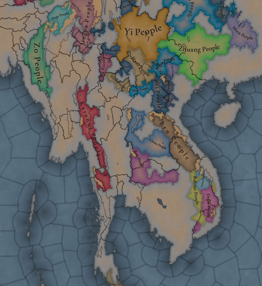
A region very rich in Societies of Pops, which will make it definitely an interesting area.

Dynasties
Dynasties.png

The dynasty of the old Pagan Empire is still alive in Prome, with many other dynasties in the region having ties with it, while the different Thai dynasties also have ties among each other.

Locations
Locations.png

Locations zoom 1.png

Locations zoom 2.png

Locations zoom 3.png

Provinces
Provinces.png

Provinces zoom 1.png

Provinces zoom 2.png

Areas
Areas.png

Unfortunately, currently the name of the sea area encroaches too much into the land (this will be fixed, don’t worry), but the blue area that gets underneath that name is Chao Phraya.

Terrain
Topography.png

Vegetation.png

Climate.png

Tropical and jungle almost everywhere, with quite a bit of comparison between the southern flatlands and the northern mountainous areas.

Development
Development.png

Not as developed as the surrounding India or China, but the main centers of power (like Angkor, Pagan, and Sukhothai) are a bit more developed.

Natural Harbors
Natural Harbors.png


Cultures
Cultures.png

A quite variety of cultures, although the southern areas haven’t had their minorities done yet so there will be even more variation there.

Languages
Languages.png

As an addition from this week one, we have a new map to show with the languages. Keep in mind that this area hasn't had any language families or dialects done yet, so there is a bit of grouping.

Religions
Religion.png

Again, keep in mind that minorities are not done, so there will be more variation added inside the Theravada block, as there has to be still quite a bit of Hinduism presence in Khmer (its conversion from Hinduism to Buddhism at that point was one of the causes of its decline), and quite a bit more of Satsana Phi among all the Tai peoples.

Raw Materials
Raw Resources.png

Raw Resources zoom 1.png
Raw Resources zoom 2.png
Raw Resources zoom 3.png
Quite a variation of resources, although dominated mainly by lumber and rice.

Markets
Markets.png

The commerce is dominated by those countries benefiting from sea trade routes, but the emergence of a strong Ayutthaya Kingdom in the middle will for sure cause a change in the balance of powers.

Population
Population.png

Population zoom 1.png
Population zoom 2.png
Population zoom 3.png
Population zoom 4.png
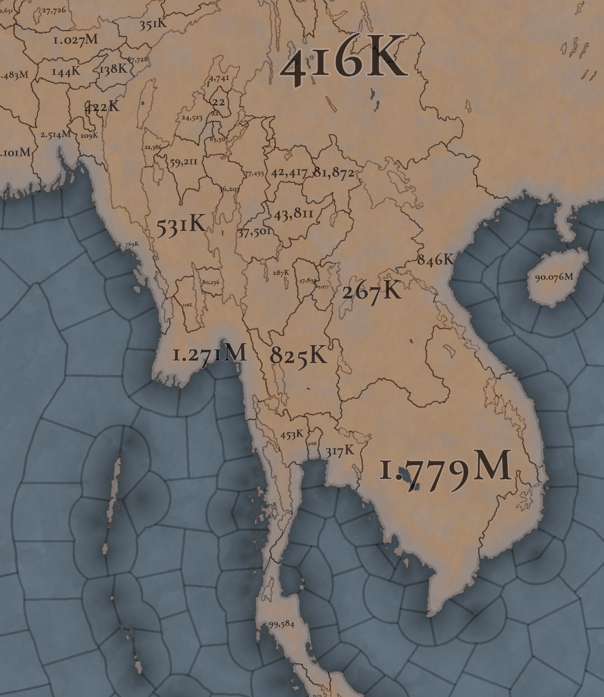
Khmer is still the most populated, but other countries around don’t fall that far behind, especially when they manage to unify their areas a bit. There’s also a couple of locations appearing as 0 population that is definitely a bug that will have to be fixed.

That is all for this week. Join us next week when we set sail to take a look at the maritime part of South East Asia by taking a look at all the archipelago of Indonesia (including the Philippines). Hope to see you there.
 
  • 117Like
  • 39Love
  • 3
  • 1
  • 1
Reactions:
I think it's finally time to talk about inaccuracies regarding the population of Dai Viet, namely that it is too low. All current academic estimates put it at at least 3 million in this period (footnote in Victor Lieberman's "Strange Parallels: Southeast Asia in Global Context", page 368) and I have even heard there are estimates putting it at 4-5 millions (!). Currently in the game it's at 847k, which is just way too low.
To add to this, Maddison (see this book) estimates the following population for Vietnam:
1500 3835k
1600 4447k
1700 5171k
1820 6551k
If we extrapolate the growth rate, we get 3041k in 1337.
Also, just to list the numbers from the book you're citing, the figure for the Red River Delta is 2.4 million in 1340 and above 3 million including the southern regions (which weren't nearly as densely populated), while there is another figure of 3.3 million for the entire kingdom.

So 4 or 5 million for just Dai Viet sounds pretty high. The more conservative estimate would be 2.4 million for the delta and maybe ~900k for the rest of Dai Viet, Champa and parts of Khmer - i.e. all the areas that make up modern Vietnam.
 
  • 9Like
  • 4
Reactions:
I find it weird to name a province "Angkor Wat" (which is just the big temple in the city of Angkor (Angkor Thom)).
Maybe call the location Angkor Thom and the province Angkor (or vice versa). Leave Angkor Wat for the building/wonder.
 
  • 13Like
  • 6
  • 1
Reactions:
Regarding the population in the modern borders of Thailand:

It appears to be roughly at 2.4 million on the map shown.
However, the figures listed for Thailand in the book mentioned above are:
1500 2000k
1600 2236k
1700 2500k
1820 4665k
If we extrapolate the 0.118% growth rate in earlier centuries, we get 1677k for 1337.

2.4 million is quite a bit more than 1.68 million (43% more). Where does this discrepancy come from?

I've also added up the population of the provinces on the Malay Peninsula (Phetchaburi, West Kra, East Kra, Thammarat and Pattani) and arrived at roughly 245k (some of them are impossible to read).

Now, based on the figures in the same book, I am estimating the population of Peninsular Malaysia (+Singapore) to have been around 88k in 1337! Yes, the Malay Peninsula was very sparsely populated, or rather most of it wasn't really populated at all and most people lived in small settlements along the coast.

So if the non-Thai part of the Malay Peninsula had a population of 88k in 1337, then 245k for the Thai part sounds super high.
You gave Pattani a population of roughly 45k. In my proposal that I'll post next week, I have it at 13k, matching the numbers in the rest of Malaya. (Edit: I revised my proposal, see my post below, and it's now 24k for Pattani)

So ultimately I am wondering what these population numbers are based on? I'm not necessarily saying that I'm correct and these higher numbers are wrong, but we've seen population numbers in previous Tinto Maps that were quite wrong (and I think we can all agree that the Dai Viet numbers here are off as well), so I'm skeptical.

To me it looks like the population on the Malay Peninsula is significantly overestimated, and the population of Thailand is somewhat overestimated.


Burma seems to be overestimated even more? I counted around 3 million in the borders of modern Burma, and its population is supposed to have been very close to Thailand (slightly more)...
 
Last edited:
  • 7Like
  • 3
Reactions:
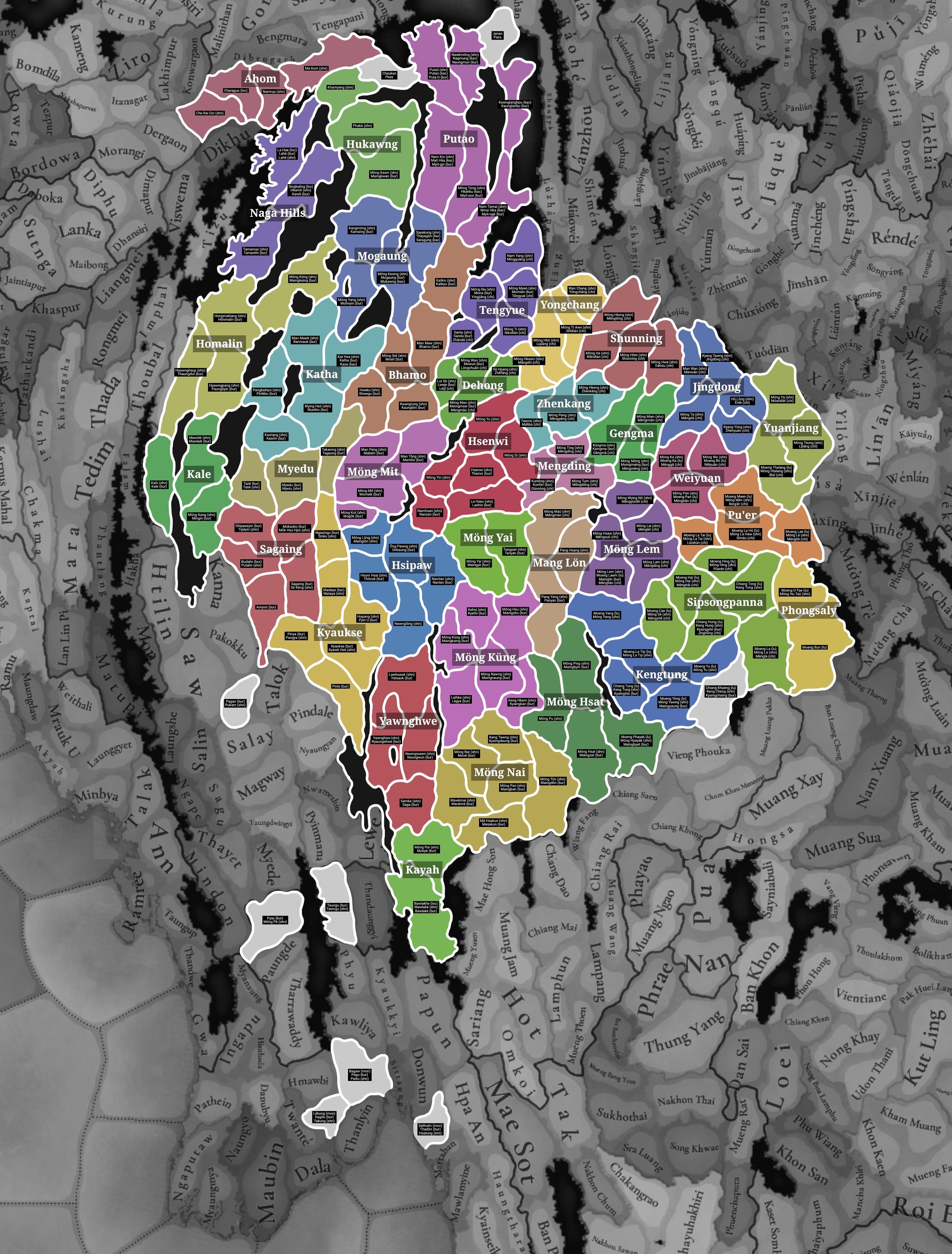
Upper Burma and the Shan People

Hi, this will be a long post, I hope it can be helpful.

A brief history lesson:
In 1337, the situation in Burma is often called the period of "Shan domination", for the last 100 years Shan people had been migrating further into Burma and setting up their own independent principalities and towns, which are called "Möngs" (this is the same word as the Thai "Mueang"). The Shan people would often raid and settle into old Burmese lands, in 1365 this got so intense due to the focus of the Möng Mao empire that it led to the collapse of the Sagaing and Pinya kingdoms, and the founding of the new Ava kingdom. However, this wasn't the complete end of the "Shan domination", which continued for the next 2 centuries and culminated in 1527, when the Shan kingdoms conquered Ava. This partly contributed to the rise of the Taungoo dynasty in the south, who very soon reconquered Burma. After this point, Shan history essentially merges with Burmese history, though they still maintained their semi-autonomous Möngs.


Locations
Locations_20250418152543-min.jpg

See this post for details

A lot of new names, I've adjusted any errors/inconsistencies, removed any modern names (e.g Taunggyi), and added the transliteration of Shan names for many other places. Some might be suitable as default English names, while others are better as dynamic names. The transliteration system I used is the traditional system which gives us recognizable names like "Hsenwi", "Hsipaw", etc. You can find a guide for this system in a document called Tables for the transliteration of Shan names into English.

I also changed some of the borders and added new location and wasteland suggestions, being mindful of geography, history, and the original map you guys designed. The increase in location density is about +20%, which hopefully isn't too much! But as far as I can tell my suggestions look more similar to the density in the regions directly neighbouring it.


Countries
Countries_20250302122229.jpg

See this post for details

An interesting time period, Möng Mao is on the verge of huge conquests into all of the other Shan states, essentially uniting them into a confederation which would challenge Burma and China for the remaining century.

Also, it's best to be consistent with names and have Möng/Moeng as a separate word from the rest of the name. It's the same as e.g. Möng Mao and Muang Sua where it's already separated. It's also how the states are named on English Wikipedia and many sources.


Cultures

Dai, Shan, and Ahom is a strange way to split the cultures, and this would have been especially true in 1337. The "Dai" name is just a designation used by the Chinese government for Tai Nüa, Tai Lü, Tai Dam, and by extension all other Tai-speaking peoples.

Cultures.jpg

Here's a little map I made showing different Northwestern Tai subgroupings. The reason I made this isn't because I think this is how it should ne represented, it's just a demonstration of the actual differences since the culture is already split into Ahom, Shan, and Dai, seemingly based on modern political borders and those groupings. Thicker lines mean a bigger difference, and the thinner lines within the thicker lines means a subgroup, I'm sorry if it's confusing but it's better than trying to read it all from scratch.

The largest dialectal difference is between East (Lü/Khün) and West (Shan, Ahom, Tai Nüa, and subgroups). The next largest is between the Northern dialects (N. Shan, Mao, Nüa, Shan-ni, Khamti, Ahom) and the Southern dialect, all of the Northern dialects have more in common with eachother than any one of them has in common with Southern Shan. After this point the groups start getting difficult to categorize properly, but each of these groups has (to some extent) a variation in their written script, which could be an indication of linguistic differences, or it could just be an indication of a fragmented political history.

I don't think there needs to be any further split than into Shan (Western) and Lü (Eastern). There isn't enough research on the level of divergence in the 14th century, and most major migrations were currently underway, which would suggest similarity, not to mention that making Shan so granular would require the same for other cultures in the region. There is also an account from the Ming dynasty in the Baiyi Zhuan, where they only split the Tai people living in Yunnan and Burma into the "Greater Baiyi" (in the west) and "Lesser Baiyi" (in the northeast and in Chiang Hung).

Further reading:


The Jingpo people had not spread so far south yet in 1337, their original homeland was in the Tibetan plateau, and they began spreading southwards sometime between the 13th-17th century. The Upper Burma Gazetteer (linked above in the location details) mentions that there's no evidence that the Kachin (Jingpo) people lived any further south than Myitkyina until the late 18th century. The Hukawng valley (northwest of Mong Kawng) was entirely Shan until the 18th century, and the Patkai hills to the northwest had a small Shan population (around modern Pangsau) and a number of Naga tribes (as mentioned in the Ahom chronicles).

A culture that could be added would be the Kadu people, who lived alongside the Shan in areas from Mong Kawng to Wuntho and possibly as far as Kale. The Kadu were valley-dwelling people like the Burmese and Shan.

There was also a small presence of Shan people in the Burmese central valley. https://www.academia.edu/3768911/Cr...he_Ming_in_the_Tai_Frontier_Zone_1382_1454_77 "After Pagan’s collapse in the late thirteenth century until the pacification of the Shan hills by the First Toungoo Dynasty in the mid-sixteenth century, the valley’s northern and eastern frontiers lay open to waves of Shan [Tai] migrants, who settled in Yamethin, Meiktila, Toungoo, Ava, and Taungdwingyi districts. Although these irruptions killed some local cultivators and dislocated agriculture, they probably produced a net increase in the population of the lowlands, especially since many displaced Burmans simply moved south to open new lands in the Upper Irrawaddy delta and the Sittang corridor (Lieberman, 1991, 4)"


Religion

In this period, the Shan people did not practice Theravada Buddhism in any large numbers. Their beliefs were partially influenced by Buddhism, but this was from forms of Mahayana Buddhism, using Sanskrit instead of Pali and having certain practices unique to Mahayana. Most of their practices were still based around their traditional religion (Satsana Phi) which included ancestor/spirit worship, animal sacrifices, a pantheon of deities, etc.

This changed in the 16th century during King Bayinnaung's reign, after conquering the Shan states he sent Burmese missionaries to the "heretic" Shan states, and from then on they became Theravada Buddhists.
(https://epress.nus.edu.sg/msl/reign/hong-wu/year-30-month-9-day-19) (https://www.burmalibrary.org/en/the-shans-vol-i (page 150))

Also, I noticed that you changed the Ahom religion from Satsana Phi to Phuralung. The Ahoms brought their religion from their original home in the Shan states, inviting scholars and priests who remained in contact with eachother for centuries to come. This change should either be reverted, or all of the Shan people should follow the "Phuralung" religion, because these were really just the same thing.


Population

The concentration of pops could be moved around a bit. The most important detail is that Mong Mao and Mong Kawng were (according to Shan, Burmese, and Chinese histories) the strongest states throughout the time period, due to their positions in very fertile and populated valleys. For some sort of reference, Captain Hannay remarked in 1836 that Bhamo (Manmaw) was the largest town he had seen in Burma, and in Volume 1 of the Gazetteer of Upper Burma, this is said about Mong Kawng: "Here it is only necessary to say that the town of Mogaung bears every appearance of having once been a large and very thriving centre. Its area is considerably larger than that of Bhamo and it contains several miles of paved streets." There's also other forms of evidence, such as the war between Mong Kawng and the Ahom Kingdom in 1401 (https://en.wikipedia.org/wiki/Sudangphaa), in this war the countries were essentially an equal match for eachother, which seems crazy when you look at the map and see Mong Kawng with a population of 4k and Ahom with a population of 300k.


Other details

I think a market should be added to upper Burma, the Tea Horse road was very active during this period, and was sometimes competitive with the sea routes. Some historians speculate that the migrations of the Shan west and the expansion of Mong Mao were both directly tied to these trade routes (https://so06.tci-thaijo.org/index.php/pub_jss/article/view/158133) Trade in central Burma was apparently not very active in this time, which is why I would suggest Man Maw (Bhamo) being the market center. Bhamo was an important center on the trade route because it's the point where the overland trade route combines with the trade sailing up and down the Irrawaddy, it was even included in a Venetian map of the 1400s for its importance.

On Shan names (of people) try to keep track of what language a name has been translated from, as an example, the Shan ruler "Hsö Hkan Hpa" might have his name written as "Si Kefa" in Chinese, "Thohanbwa" in Burmese, and something like "Sukanphaa" in Assamese.
 
Last edited:
  • 21
  • 15Like
  • 8Love
  • 1
Reactions:
What makes you say they yuan should be blue?

I want it to be red, idk why but it feels like the best for yuan,

What type of blue are you talking about?
Red Yuan is an artificial colour selection made by EU4, which is presumably why you feel like it's the best (along with the brownish Ming colour), but there isn't a real historical basis for that. Of course, colours can be completely arbitrary and for many nations they necessarily will be, but since Yuan and Ming are such pivotal states during the game's time period, I'd like to see something more historical for them instead of just clinging to what was the case in previous games.

As regards the colours I would prefer, Ming is in my eyes a shoe-in for red. Red is the colour associated with the Han Chinese and the Ming emperors' surname, 朱 (zhū), means cinnabar, which was historically used to make a very nice deep red pigment. For Yuan, white (the colour chosen by them as their imperial colour, associated with the element metal) or some sort of blue (the colour of the Mongol people) are both fine options. I personally favour white.
 
  • 8
  • 4Like
Reactions:
I am very interested in this region.
 
  • 1Haha
  • 1Love
Reactions:
I have done extensive research about Vietnam (Dai Viet and Champa) in the late Tran dynasty era, especially the 14th century so I have a few comments which I hope that will be incorporated into the game. I am happy to answer questions if needed.

===== Dai Viet population =====
I don't know if anyone mentioned this, but the Vietnamese population is unacceptably low and please address this. Most of the sources have estimated the Vietnamese population ranged between 2 million to 3 million at the start date. I shall include some references below:

[1] LIEBERMAN, V., & BUCKLEY, B. (2012). The Impact of Climate on Southeast Asia, circa 950–1820: New Findings. Modern Asian Studies, 46(05), 1049–1096.
"Accordingly, the population in northern Vietnam grew from an estimated 1,600,000 in 1000 to 3,000,000 in 1300"
"Vietnam has higher population density than Angkor and Pagan so the pressure must be higher".

[2] LIEBERMAN, V. (2011). Charter State Collapse in Southeast Asia, ca. 1250–1400
"In Dai Viet as well, local records and chronicles point to growing land constraints. After 950 or 1000, reclamation moved from hilly regions north and west of the Red River basin into coastal and deltaic regions to the south and east, where peasants built polders, drainage systems, and irrigation works. Taming the delta was more taxing than cultivating the foothills, but more rewarding insofar as fertile soil and abundant water permitted multiple cropping. Aided by court-sponsored hydraulic projects, the population of the delta, Yumio Sakurai estimates, mushroomed from 1.2 million in 1200 to 2.4 million in 1340. From the late 1200s, however, as new tracts became more marginal, reclamation stalled. This slowdown combined with continued population growth and land engrossment by notables to reduce per capita allotments, which depressed peasant income and accelerated the conversion of taxpayers into servile laborers. Beginning in 1343, annals refer repeatedly to uprisings by starving vagabonds, monks, and dependents championing such slogans as “Relieve the impoverished people.” In 1389, vagabonds occupied the capital for three days. Such disturbances joined emigration, drought, disease, and Cham attacks to reduce the delta population to perhaps 1.6 million in 1400."

There's also another work by Li Tana that estimated the Vietnamese population to be around 2.4 million during the Tran dynasty.

Side notes: Dai Viet has one of the highest population density in the area, so one could use that information to estimate the population as well. Even with many disasters in the 1300s, the scholars have estimated Dai Viet to have at least 1.6 million in this period, so having any number less than 1 million (or even 1.5 million) is completely unacceptable. Another information one can use is that the Tran dynasty in the 1330s is at the height of its power (although it is starting to decline from this point forward) as well.

===== Dai Viet economy =====
There should be a Bronze mine in Lang Son area (I noticed that there is a silver mine, which is OK I guess since that area is known to produce gold also). Lang Son was critical to Dai Viet in Ly-Tran era due to their production, which helped mint coins and balance budget. Gold and silver was an important Dai Viet export of the time.

[3] Mate, M. E. (1984). Precious Metals in the Later Medieval and Early Modern Worlds. Edited by J. F. Richards. (Durham, N.C.: Carolina Academic Press, 1983. ix + 502 pp.). Business History Review, 58(3), 457–458. doi:10.2307/3114580
  • During the fourteenth century, a shortage of copper and of Chinese cash relative to demand seems to have occurred since the Vietnamese in the 1320s again began to mint their own cash and had to use zinc for the coins. Vietnamese copper coins from the mid-century were conspicuously small and thin.
  • Copper does not figure nearly so much in the early historical records as do silver and gold. It was not exploited by the T'ang, and the first mine mentioned was opened in the northern mountains of Lang-son only in 1198.
  • Information contained in Chao's text would suggest that gold and silver were important Vietnamese products which moved along both primary and secondary trade routes. Chao tells us that gold and silver were among the top Vietnamese products. He also notes that Cambodia was in the market for these precious metals, producing none itself, and that Kuala Berang (Kelantan) on the east coast of the Malay Peninsula, Srivijaya on Sumatra, and east Java all sought gold and silver as desired commodities.

Dai Viet economy initially has a strong agricultural output but towards this century, natural disaster and low governmental efficiency has significantly reduced the output. Dai Viet was overpopulated in this time period so there was huge ecological stress (again, it is unacceptable for the population to be that low, not just Dai Viet but Pagan and Khmer also I believe), which is a common characteristic across all Southeast Asian charter states (Pagan, Khmer and Dai Viet). The decline of these states in this time period was partly because of natural disasters (Dai Viet) and ecological stress (Khmer) so natural disaster events would be very interesting here.

[1] LIEBERMAN, V., & BUCKLEY, B. (2012). The Impact of Climate on Southeast Asia, circa 950–1820: New Findings. Modern Asian Studies, 46(5), 1049–1096. doi:10.1017/S0026749X12000091
  • The Upper Burma state, centered originally at Pagan, faced Mongol invasions after 1277, revolts in Lower Burma from 1287, and calamitous Shan invasions from the northern hills that climaxed between 1359–1368.
  • In summation, if political and institutional development at Angkor preceded that at Pagan and Dai Viet and if (on present evidence) the Vietnamese economy in the late thirteenth century showed somewhat greater vitality than its Khmer or Upper Burmese counterparts, for most of the period between 950 and 1300 all three realms saw a dramatic increase in cultivation and population and an elaboration of imperial institutions.
===== Dai Viet politics =====
Additionally, how Vietnamese provinces are decided should be revisit too I think, if possible other Vietnamese can comment on this.

The Dai Viet controlled part in central Vietnam (modern-day Hue) should not be speaking Champa, but maybe a mix of both or a dialect of Vietnamese since that region was controlled by Dai Viet for 30 years already.

I can comment more on the economic and political dynamic of the Tran dynasty if PDX wants to create some disaster events in this period. A brief overview is that Dai Viet's court politics was destroying the country from the inside, and the Buddhist clergy class was influencing heavily during this period which caused a decline in revenue.

===== Champa territory =====
In terms of Champa, the Central Highland of modern day Vietnam should be tribal lands, or at least low control Champa land since Cham people was known to live and mix in the Central Highland. Most notably, the Chams were hiding and fighting guerilla wars from the Central Highland against the Mongols during their 1282 invasion. At the same time, Khmer Empire is exercising very low control on the periphery towards the 1200 and definitely declining in the 1300s, so the border in the map does not make sense. If the PDX believes otherwise, it should be backed up by credible sources.

===== Champa economy =====
While Champa is smaller than Dai Viet in this era with a small agricultural output, Champa trade was flourishing in this era. I think we can reflect this with an event giving Champa trade efficiency/trade power for a period of time in this era (note that this does not last since the Vijaya trade will decline later).

[4] Whitmore, K. J. (2011). The last great King of classical Southeast Asia: "Chế Bồng Nga" and fourteenth-century Champa.
  • As Java’s economy grew, Champa became more involved with it. The Cham ports, especially Sri Chanoy (Thị Nại) in Vijaya, served an important linking role between the Javanese and Chinese ports; as one Chinese source noted, Champa was the way to Java
  • A major recent theme for the discussion of Southeast Asian history has been how the surge of trade in the fourteenth century strongly affected in a very negative way the great classical empires, especially Angkor and Pagan. The coastal regions favored by this commercial surge developed their own strength and undercut that of the classic inland capitals. In the process, Pagan and Angkor would be abandoned and Pegu, Ayudhya and Phnom Penh would rise in their places.
  • Champa was strongly linked to the growing Muslim trade of the era and seems to have joined the Javanese in their embassies to China. Being part of this broad commercial and diplomatic network would have brought the Cham not only to the Chinese capital and its tributary rituals, but also to the opposite pole in the network, that of Java and Majapahit.
As we can see, Champa was benefitting heavily from the Indonesian trade and the rise of Majapahit. Meanwhile, Dai Viet was mostly trading in the Canton node:
  • Canton, however, was the main port of call for the Vietnamese, and they went from there to Malacca on Chinese or Ryukyuan junks. Few Vietnamese ships went directly to Malacca.
===== Champa politics =====
[5] Proctor, Ann R. (2018), Buddhist Art of 9th Century Campa: Đồng Dương, Cambridge Scholars Publishing, p. 140
"Cham societies dominated two-thirds of the narrow central coast of what is now Vietnam for over one thousand years––from the third/fourth century until 1720, when the Cham finally came under the suzerainty of the Vietnamese. The society appears to have been a polity of loosely aligned principalities based in the riverine valleys along approximately one thousand kilometres of the coast. This collection of regional chiefdoms was united by a common language and culture."


===== Final note =====
If you were concerned about more population will skew the balance of the region, you can create rebel events/disasters to balance it out (for example, Dai Viet has a peasant rebellion by Ngo Be in 1344). Having this low population is unplayable in my opinion.
 
Last edited:
  • 16Like
  • 7
  • 2
Reactions:
Why Champa has such a low population, I'm sure that it cannot be this low, especially this period is the height of Champa. I believe that Champa must have had at least double this.

Instead of having low population, you should enact low control for Champa, or Champa as a confederation of petty kingdoms. This is because Champa is a polity of loosely aligned principalities under a Mandala structure.

[1] Proctor, Ann R. (2018), Buddhist Art of 9th Century Campa: Đồng Dương, Cambridge Scholars Publishing, p. 140
"Cham societies dominated two-thirds of the narrow central coast of what is now Vietnam for over one thousand years––from the third/fourth century until 1720, when the Cham finally came under the suzerainty of the Vietnamese. The society appears to have been a polity of loosely aligned principalities based in the riverine valleys along approximately one thousand kilometres of the coast. This collection of regional chiefdoms was united by a common language and culture."
 
Last edited:
  • 4Like
  • 2
  • 1
Reactions:
Ultimately inconsequential complaint, but I'd refer to the country as "Cambodia" since it's what it called itself (កម្វុជ, Kambuja), while also being more familiar to modern audiences. "Khmer Empire" is a modern historiographical convention. It's also nice that you guys fixed the name order issue though ("[adjective] Empire" rather than "Empire of [country]").
While on the topic of tags: In EU4 I always thought it was weird that Taungoo was just Taungoo, even in the Konbaung period. Any Burmese history experts can tell me if it would make sense for there to be separate tags? Perhaps there should be a single "Burma" tag? Will there also be an event for Đại Việt becoming Việt Nam, as just a comestic thing rather than as a tag switch?
Đại Việt became Việt Nam in 1804, so calling Đại Việt at the start is correct (unless you want to enact an event for name change later)
 
  • 3Like
  • 1
Reactions:
Regarding the population in the modern borders of Thailand:

It appears to be roughly at 2.4 million on the map shown.
However, the figures listed for Thailand in the book mentioned above are:
1500 2000k
1600 2236k
1700 2500k
1820 4665k
If we extrapolate the 0.118% growth rate in earlier centuries, we get 1677k for 1337.

2.4 million is quite a bit more than 1.68 million (43% more). Where does this discrepancy come from?

I've also added up the population of the provinces on the Malay Peninsula (Phetchaburi, West Kra, East Kra, Thammarat and Pattani) and arrived at roughly 245k (some of them are impossible to read).

Now, based on the figures in the same book, I am estimating the population of Peninsular Malaysia (+Singapore) to have been around 88k in 1337! Yes, the Malay Peninsula was very sparsely populated, or rather most of it wasn't really populated at all and most people lived in small settlements along the coast.

So if the non-Thai part of the Malay Peninsula had a population of 88k in 1337, then 245k for the Thai part sounds super high.
You gave Pattani a population of roughly 45k. In my proposal that I'll post next week, I have it at 13k, matching the numbers in the rest of Malaya.

So ultimately I am wondering what these population numbers are based on? I'm not necessarily saying that I'm correct and these higher numbers are wrong, but we've seen population numbers in previous Tinto Maps that were quite wrong (and I think we can all agree that the Dai Viet numbers here are off as well), so I'm skeptical.

To me it looks like the population on the Malay Peninsula is significantly overestimated, and the population of Thailand is somewhat overestimated.


Burma seems to be overestimated even more? I counted around 3 million in the borders of modern Burma, and its population is supposed to have been very close to Thailand (slightly more)...
I agree with this analysis, maybe except for the Burma part.
 
  • 1
Reactions:
Is there a data source for 16th century Mongolian worldview? Personally, I think it's interesting. And Goryeo is, um... Personally, I think the same color (deep blue) as Korea in eu4 is familiar and good.
I hope I could say "yes" but I only have a paper written in Chinese, which researched on the concept of tabun ongge dorben qari, or five colors and four vassals by Borgijin Oyunbilig, from Arban buyan-tu nom-un caya teguge neretu sudur-un ekin orosiba. If you could read Chinese, the paper is just here.
 

Attachments

  • 论“五色四藩”的来源及其内涵_乌云毕力格.zip
    774,9 KB · Views: 0
  • 3Like
  • 2
Reactions:
I think central Vietnam or in Champa in this period, has many good natural harbors and really worth look into, for example Hoi An ~(Simhapura province) port became extremely prosperous through trading in the 16th to 19th century, eventually overtaken by Danang (~Dien Ban province), which is also considered a good natural harbor with deep waters surrounded by mountain and a peninsula, and speaking of defensive, in Kathuhara or modern day Khanh Hoa province there is Cam Ranh Bay considered one of the best strategic deep sea harbor in Asia, etc. I also think there should be more locations/provinces in the area in general, for more gameplay diversity.
 
  • 6Like
  • 2
Reactions:
Is there any chance to make some minor changes to the climate of the heartland of Champa (current day Binh Thuan/Ninh Thuan provinces in Vietnam) - it's really quite an arid place similar to the one in Burma. Their heartland is almost desertlike with sand dunes along the coast and sparse dry vegetation inland. I would even change it to not be producing rice. Maybe the product could change to salt or fish.

You'll notice Isan (the Korat plateau) is also listed as savannah, not jungle.
egetation-class-distribution-of-mainland-Southeast-Asia-Three-classes-form-a-mosaic-in.png
 
  • 5Like
  • 2
  • 1
Reactions:
Putao (Putawng) is an ancient settlement dating back to the Nanzhao period, and appeared in Yuan Dynasty records as Pudong Dian (蒲東甸). It will be reasonable to assume that in the year of 1337, there were some local polities in Hkamti Long, either independent or loosely affiliating to Mogaung.

The routes leading to Assam in the west and Gongshan in the east had served as trade routes and migratory corridors of various ethnic groups, so they should not be blocked by impassable mountains.

Source: Institution of Kachin Du-Waship (1852-1930) / Kaw Nan. Degree, Ph.D. University&Year, University of Mandalay 2013.
 

Attachments

  • hkamti.jpg
    hkamti.jpg
    268,9 KB · Views: 0
  • hkamti2.jpg
    hkamti2.jpg
    229,6 KB · Views: 0
Last edited:
  • 3Like
Reactions:
Adding to the population discussion, I also found this table in Southeast Asia in the Age of Commerce:

seapopstats.png


Compared to Maddison, there are some differences. Comparing 1600:
Burma 3100 vs 2380
Siam 1800 vs 2236 (this can be explained by parts of Thailand being counted for Laos)
Vietnam 4700 (no south) vs 4447
Cambodia 1230 (includes southern vietnam) vs 1419
Laos 1200 (with parts of Thailand) vs 319
Malaya 500 vs ~150
Indonesia ~9500 vs 11839

Now Indonesia is for next week and I'd even consider the lower estimate to be quite high.
The difference for Malaya is huge! On an earlier page there's also the figure of 50-60k for Kedah, but going off of that, it would be more like 368k for all of Malaya. Estimating a net 0 population growth over 200 years is also pretty bold. If the raids in 1618/19 were really that devastating, then estimates for pre-1600 population, which were likely extrapolated have to be bumped up quite a bit.
Laos has a bit more, even considering the Thai territory.
Thailand probably has the closest figures.
Vietnam is quite a bit higher, but that does align with other cited figures earlier in the thread that were somewhat higher than Maddison.
Cambodia's figures are insanely low, considering that some of it has to be counted for Vietnam.
Burma has a lot more population here.

Just for fun I'm going to take both of the estimations I posted, average them (or favor one over the other, like in the case of Cambodia) and extrapolate what 1337 population distribution could look like:

Burma2000k
Thailand (without Pattani)1680k
Laos360k
Vietnam (north and central)3000k
Southern Vietnam700k
Cambodia1000k
Pattani~24k

So compared to these numbers, the populations posted in the OP are: way too low for Northern Vietnam, too low for Southern Vietnam, too high for Cambodia, way too high for Thailand, way too high for Burma and too low for Laos. Also, using significantly higher estimates for Malaya, Pattani is still at double the population.

Obviously, the further back the numbers go, the worse they will be, since growth rates weren't constant and things like plagues and war can have a big impact. It's all just guesswork and what the exact numbers end up like doesn't really matter that much, but I think it would be good to at least have a somewhat accurate distribution within the region, e.g. changing it so Vietnam has the highest population.
 
Last edited:
  • 5Like
  • 3
Reactions:
Since I am a Vietnamese, I want to make some questions regarding Vietnam/Đại Việt:
1. Why are "Diện Bàn", "Bồng Sơn", "Hà Vả Nguồn", "Sông Bé" and "Di Dinh" names for locations in Champa and the Khmer Empire, when they're clearly Vietnamese names?
2. About provinces:
- Is it "Hải Đông" or "Hải Đồng"? The font kind of makes them a bit hard to differentiate.
- "Thăng Long" province should be called "Đông Đô"
- "Nam Sách" should be called "Lạng Giang", in which Nam Sách was a part of.
- I can't find any historical sources on the name "Tru Viện", Are there any specific reasons why it is called as such?

Other than that, I am quite content with the rest of Vietnam. You guys at Paradox Tinto are doing a good job, keep it up!
 
  • 2
Reactions:
Since I am a Vietnamese, I want to make some questions regarding Vietnam/Đại Việt:
1. Why are "Diện Bàn", "Bồng Sơn", "Hà Vả Nguồn", "Sông Bé" and "Di Dinh" names for locations in Champa and the Khmer Empire, when they're clearly Vietnamese names?
2. About provinces:
- Is it "Hải Đông" or "Hải Đồng"? The font kind of makes them a bit hard to differentiate.
- "Thăng Long" province should be called "Đông Đô"
- "Nam Sách" should be called "Lạng Giang", in which Nam Sách was a part of.
- I can't find any historical sources on the name "Tru Viện", Are there any specific reasons why it is called as such?

Other than that, I am quite content with the rest of Vietnam. You guys at Paradox Tinto are doing a good job, keep it up!
The name "Đông Đô" appeared when Hồ Quý Ly moved the capital to the present-day Thanh Hoá region (at that time, the names "Tây Đô" and "Đông Đô" emerged). Therefore, in the year 1337, the name "Thăng Long" was already appropriate.

P/S:
Regarding the name of the province, "Tranh Hoà" is a clear historical inaccuracy; it should have been "Thanh Hoa," right?
 
  • 2Like
Reactions:
Hello, and welcome to another week of fun unveiling of the map of Project Casar. In this week’s Tinto Maps we will be taking a look at South East Asia, so without further ado let’s get started.

Countries
View attachment 1210268View attachment 1210269
Quite a variety of countries in the area. The regional power in the decades before 1337 was the Khmer Empire, although at this point they are already in decline and have lost much of their previous hegemony. On the west, the fall of the Burmese Pagan Kingdom and the following Mongol invasions gave rise to the disunited kingdoms of Pinya, Sagaing, Prome, and Toungoo, while in the south the Mon kingdom of Hanthawaddy (also known as Pegu) also split apart. On the center, the decline of the old Lavo Kingdom and its subjugation to the Khmer gave way to the emergence of the Kingdom of Sukhothai when Khmer started its decline too, and Sukhothai is emerging as the dominant Thai kingdom in the area. However, Ayodhya is already gestating the rise of another great kingdom, as King Ramathibodi, the founder of the Ayutthaya Kingdom is already poised to gain power in the region. On the east coast, the Kingdom of Đại Việt is under the orbit of the Yuán, with constant conflict with the southern Hindu kingdom of Champa.

Societies of Pops
View attachment 1210270
A region very rich in Societies of Pops, which will make it definitely an interesting area.

Dynasties
View attachment 1210271
The dynasty of the old Pagan Empire is still alive in Prome, with many other dynasties in the region having ties with it, while the different Thai dynasties also have ties among each other.

Locations
View attachment 1210272

Provinces
View attachment 1210276

Areas
View attachment 1210279
Unfortunately, currently the name of the sea area encroaches too much into the land (this will be fixed, don’t worry), but the blue area that gets underneath that name is Chao Phraya.

Terrain
View attachment 1210280
View attachment 1210281
View attachment 1210282
Tropical and jungle almost everywhere, with quite a bit of comparison between the southern flatlands and the northern mountainous areas.

Development
View attachment 1210283
Not as developed as the surrounding India or China, but the main centers of power (like Angkor, Pagan, and Sukhothai) are a bit more developed.

Natural Harbors
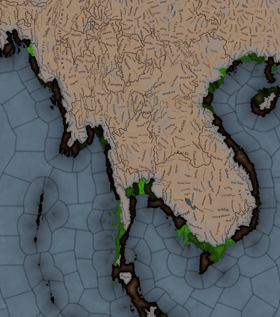
View attachment 1210284

Cultures
View attachment 1210285
A quite variety of cultures, although the southern areas haven’t had their minorities done yet so there will be even more variation there.

Languages
View attachment 1212849
As an addition from this week one, we have a new map to show with the languages. Keep in mind that this area hasn't had any language families or dialects done yet, so there is a bit of grouping.

Religions
View attachment 1210286
Again, keep in mind that minorities are not done, so there will be more variation added inside the Theravada block, as there has to be still quite a bit of Hinduism presence in Khmer (its conversion from Hinduism to Buddhism at that point was one of the causes of its decline), and quite a bit more of Satsana Phi among all the Tai peoples.

Raw Materials
View attachment 1210287
Quite a variation of resources, although dominated mainly by lumber and rice.

Markets
View attachment 1210291
The commerce is dominated by those countries benefiting from sea trade routes, but the emergence of a strong Ayutthaya Kingdom in the middle will for sure cause a change in the balance of powers.

Population
View attachment 1210292
Khmer is still the most populated, but other countries around don’t fall that far behind, especially when they manage to unify their areas a bit. There’s also a couple of locations appearing as 0 population that is definitely a bug that will have to be fixed.

That is all for this week. Join us next week when we set sail to take a look at the maritime part of South East Asia by taking a look at all the archipelago of Indonesia (including the Philippines). Hope to see you there.
Fantastic stuff! Though, when will you start calling Societies of Pops to Stateless Societies? It just sounds so much better.
 
  • 3
  • 1Like
Reactions: