• We have updated our Community Code of Conduct. Please read through the new rules for the forum that are an integral part of Paradox Interactive’s User Agreement.

Tinto Maps #4 - 31th of May 2024 - Poland, Ruthenia, Baltic

Hello everyone, and welcome to the fourth Tinto Maps! The feedback that we've received so far has been great, and there will be news soon regarding the map fixes that we've already done.

This week we are showing you Poland, Lithuania, Ruthenia, and the Baltic region. Let’s check it with no further ado:

Countries
Countries.jpg

A bigger picture of what’s going on in this region today, as we hadn’t shown it entirely before. To the west, the Kingdom of Poland is ruled by Casimir III of the House of Piast. It is not a completely unified kingdom, as there are several powerful vassals under him, most of them also Piasts themselves.

To the east, the Duchy of Lithuania is ruled by Gediminas, who has greatly expanded the influence of the country into Russian lands (side note: Gediminas entitled himself in his diplomatic correspondence ‘king’, but was considered by the Pope ‘king or duke’, and the title of Grand Duke wouldn’t be formally adopted until later [most likely replicating the Russian title ‘Grand Prince’]. That’s why Lithuania starts as a Duchy, although it will have an event that would make it possible to adopt the dynamic country name of ‘Grand Duchy’).

To the south, the principalities of Kyiv and Galicia-Volhynia have recently fallen under foreign influence, the first ruled by Theodor, brother of Gediminas of Lithuania; and the second by Yuri II, also from the Piast dynasty.

To the north, the Teutonic and Livonian Orders, which conquered the lands of Prussia and Livonia a century ago, are at war against Poland and Lithuania, after a long-established rivalry.

Also, a side note: we will talk about Moldavia in the Tinto Maps devoted to the Carpathian region, as it’s currently in a ‘placeholder’ spot.


Diplomacy.jpg

A new map mode, the Diplomatic one! The game starts with an ongoing war between Poland, Lithuania, and their respective vassals, on one side, and the Teutonic and Livonian Orders, and Bohemia and its vassals, on the other.

Locations
Locations.jpg

Here you have the locations of Poland, Lithuania, Ruthenia, and the Baltic region. Some issues that have already been reported by our Polish coworkers are the inconsistencies in the location naming in Polish (we’ll use proper Polish letters more thoroughly), and we’ve also started to review both the Polish and Baltic locations based on the early feedback you gave us. Oh, also, the Vistula and Curonian Lagoons missing is a bug, we’ll properly re-add them while doing the map review.

Provinces
Province.jpg

Any suggestions for provincial naming are pretty welcome, as in the last DD!

Terrain
Climate.jpg

Topography.jpg

Vegetation.jpg


Cultures
Cultures.jpg

The Baltic lands have an interesting mix of different cultures. ‘Western Baltic’ culture represents the people speaking a West Baltic language (Old Prussians, Yotvingians, Curonians, etc.), while ‘Prussian’ is the culture of the German settlers of that area; on that style, we have a ‘Baltic German’ culture in the lands of Livonia and Estonia that also got settled by German-speaking people. The divide between Polish, Ruthenian, and Aukstaitian might be too deep, so we will most likely add a bit more mixed situation in the borders between these cultures.

Religions
Religions.jpg

A region with a more interesting religious setup! Apart from the Catholic-Orthodox divide, you can also see the Romuva religion, which was a hot topic in 1337 (shall the Dukes of Lithuania convert to Catholicism, or stay Pagan?). Red stripes to the north are other Animist populations. Also, disregard the Sunni region to the southeast, as we have to review all the pops of the Pontic Steppes, as well.

Raw Goods
Raw Goods.jpg

From the distribution of the materials, maybe a couple of things might catch your eye. The first is that there’s an Amber good present on the shores of the Baltic Sea. The second is that the Tatra Mountains, in Slovakia, have a bunch of precious metals, which makes them a very interesting area to exploit and develop.

Population
Pops.jpg

Pops 2.png

The population of the region is divided into country and location views. Two notes: The total population of Estonia is not 711K people, that’s the total for its owner, Denmark. Second, we’ve read your feedback regarding the population map mode, and we’ll take a look at how to improve the visualization of the data, making it better for you.

EDIT: Markets
Markets.jpg

And that’s all for today! The region that we'll show next week is Italy! Cheers!
 
  • 212Love
  • 163Like
  • 10
  • 5
  • 4
  • 1Haha
Reactions:
Thank you. I believe the term Ruthenia can be used as the cultural foundation from which the Ukrainian nation could later emerge. Similarly, in the north, the culture should be Muscovites, from which Russia would eventually form (as it happened historically).

Developers need to understand that there were no "russians" in the Middle Ages as they depict in Crusader Kings 3, who then supposedly migrated north. The Muscovites named their country "Russia" by the decree of Peter the Great, using the Greek variant. Before that, they were known as Muscovites.
You do realize you're going round in circles, right? :) As of early XIV century, everyone from the Carpathians to the White Sea were Russians (in greek) or Ruthenians (in latin). This thread is for the Lithuanian part only, as depicted by the maps. If you want to discuss the Muscovite side - there are two other threads for that.
Therefore:
1) Either before the formation of such nations as Ukrainians/Belarusians/Russians, the developers should use the general term that designated the entire people of Kyivan Rus' listed in the messages above (and these are not russians as in СK3). The developers should have used this option in the game СK3.
2) Or in the case of Russians and Ukrainians, call them local terms Ruthenians and Muscovites, who form Ukraine and Russia, respectively.
It has already been done.
 
Last edited:
  • 3Like
  • 2
Reactions:
You do realize you're going round in circles, right? :) As of early XIV century, everyone from the Carpathians to the White Sea were Russians (in greek) or Ruthenians (in latin). This thread is for the Lithuanian part only, as depicted by the maps. If you want to discuss the Muscovite side - there are two other threads for that.

It has already been done.
This is good. From the very beginning, my posts were about the history of this region in the games I played, developed by Paradox (CK2, CK3, EU4, Victoria 3) so that the same historical mistake would not happen here, when the developers do not distinguish between these 3 names and make everyone russians, although this term began to be used only after Peter I renamed Muscovy and did not apply to Belarusians and Ukrainians (this is the answer to your first question)
 
Last edited:
  • 2Like
  • 2
Reactions:
Firstly, you are commenting an outdated post, because this region has already been reviewed and updated:


Secondly, in CK3 I would strongly support the use of Rus name only, but I see no problem and controversy here. The game timeframe is 1337-1837 and the ChatGPT literally supports the devs' naming:
View attachment 1235916

Thirdly, there will be Tinto Flavour for this region, the devs have confirmed that there will be unique content for Kyiv and other regional Ukrainian/Belarusian countries. They would like to have cossack-related flavour too. We will see what they have and then make further suggestions about the Hetmanate, for example. I have already suggested the ways for formation of modern-day Ukrainian/Belarusian/Russian cultures later in the game etc.

Btw, the video is really great.
Please stop trying to present randomly generated chat gpt text as a source. This is actively damaging to the integrity of the conversation.
 
  • 6Like
Reactions:
Please stop trying to present randomly generated chat gpt text as a source. This is actively damaging to the integrity of the conversation.
If you don’t see the context, I made a screenshot from the link in the message I replied to. Just to show that even his ChatGPT link says the opposite and there is nothing to complain about.
The conversation here was over months ago.
 
Last edited:
  • 4Like
  • 1
Reactions:
If you don’t see the context, I made a screenshot from the link in the message I replied to. Just to show that even his ChatGPT link says that everything is OK how the devs handled it and there is nothing to complain about.
The conversation here was over months ago.
Whether chat gpt supports how the devs handled it, is as about as relevant to the conversation as whether my cat supports how the devs handled it, that is to say, not in the slightest, and presenting this information to other people and expecting to be taken seriously is silly.
 
  • 3Like
  • 2Haha
  • 2
Reactions:
Whether chat gpt supports how the devs handled it, is as about as relevant to the conversation as whether my cat supports how the devs handled it, that is to say, not in the slightest, and presenting this information to other people and expecting to be taken seriously is silly.
I beg to differ, that cat is your liege lord and what he or she meows about this subject, stands.
 
  • 4Haha
  • 1Love
  • 1
Reactions:
Whether chat gpt supports how the devs handled it, is as about as relevant to the conversation as whether my cat supports how the devs handled it, that is to say, not in the slightest, and presenting this information to other people and expecting to be taken seriously is silly.
Come on. Gidaka started it with a Chat GPT "course", Kotyk just used the same tool to show that they were wrong. And the information discussed is not in question in any case. If this were specialized original research, condemning AI sources would make more sense.
 
  • 7
Reactions:
I did not know how game development works at Paradox, and I wrote this post based on games that have already been released. I will explain this with examples:

CK2 - Initially, the developers divided Kyivan Rus into two completely separate and unrelated states and two distinct cultures: Russians in the north and Ruthenians in the south. Later, they finally looked into historical books and made them into one culture. However, instead of calling them Rusyns, they became Russians (as I mentioned earlier, this term should only be used after Peter I declared that the Muscovites would become "Russians" starting from 1721).

CK3 - The developers removed Kyivan Rus from CK2 and replaced it with the Russian Empire in the Middle Ages!!! The culture remained unchanged, so they were still called Russians. This means that in a game about the Middle Ages, I am supposed to play as Russians in the Russian Empire (which is a historical absurdity).

Victoria 3 - For some reason, the developers are unable to find historical maps of Ukraine from this period, even though there are plenty. Firstly, the demographic distribution of Ukrainians is incorrect. Secondly, Ukraine itself is missing cities that were regional centers, for example, Katerynoslav. Ukraine is the only country in Europe that, instead of cities, has huge empty chunks on the map, while the rest of Europe is well-detailed. I'll even leave a map here as an example:

EU4 - The game has no mentions of Ukraine or the Hetmanate (you can check the YouTube video I linked earlier). However, it was already present on historical maps. For example, here is a map from 1648:

***

If, in this game, the territory of Kyiv has the Ruthenian culture that can transform into Ukrainians, and the territory of Muscovy has Muscovites that can later form Russians, I believe this will be the first game in decades where the developers finally fix this. In that case, I will preorder the game.
 
  • 5Like
  • 2
Reactions:
The Breadbasket of Latvia

It is strange and incorrect that in recent feedback the most fertile soils in the Livonian state produce lumber and wild game (highlighted below). Semigallia lowlands are considered the Latvian breadbasket, therefore it needs at least one or two locations producing wheat.
Raw materials.png


hn2j.png

1. Here is map of modern Latvia's farmland size based on economic significance. We can see that agriculture is mostly concentrated in Semigallia.


thumbnail.jpg

2. Here is a soil map from The Latvian National Encyclopedia, where the brown-colored soil between Dobele and Bauska is most fertile.

Locations 5.png


I suggest changing raw material of Mitau, Bauske, or Doblen to wheat to better represent Semigallia's agricultural potential.
 
  • 5
  • 2
  • 1Like
Reactions:
Hi, I may be a bit (too) late with a suggestion but I just want to propose small change that could be implemented and make the map more accurate. And it also better late then never : )

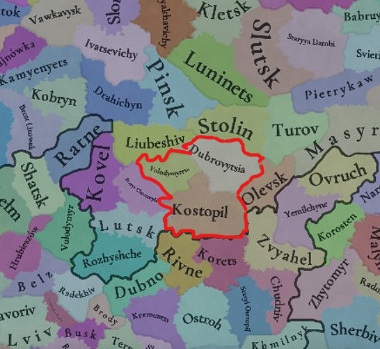
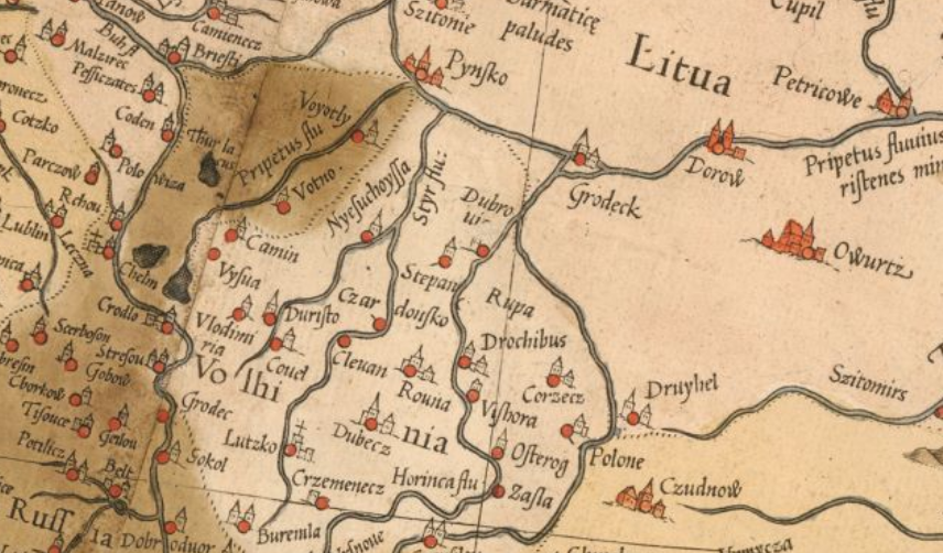
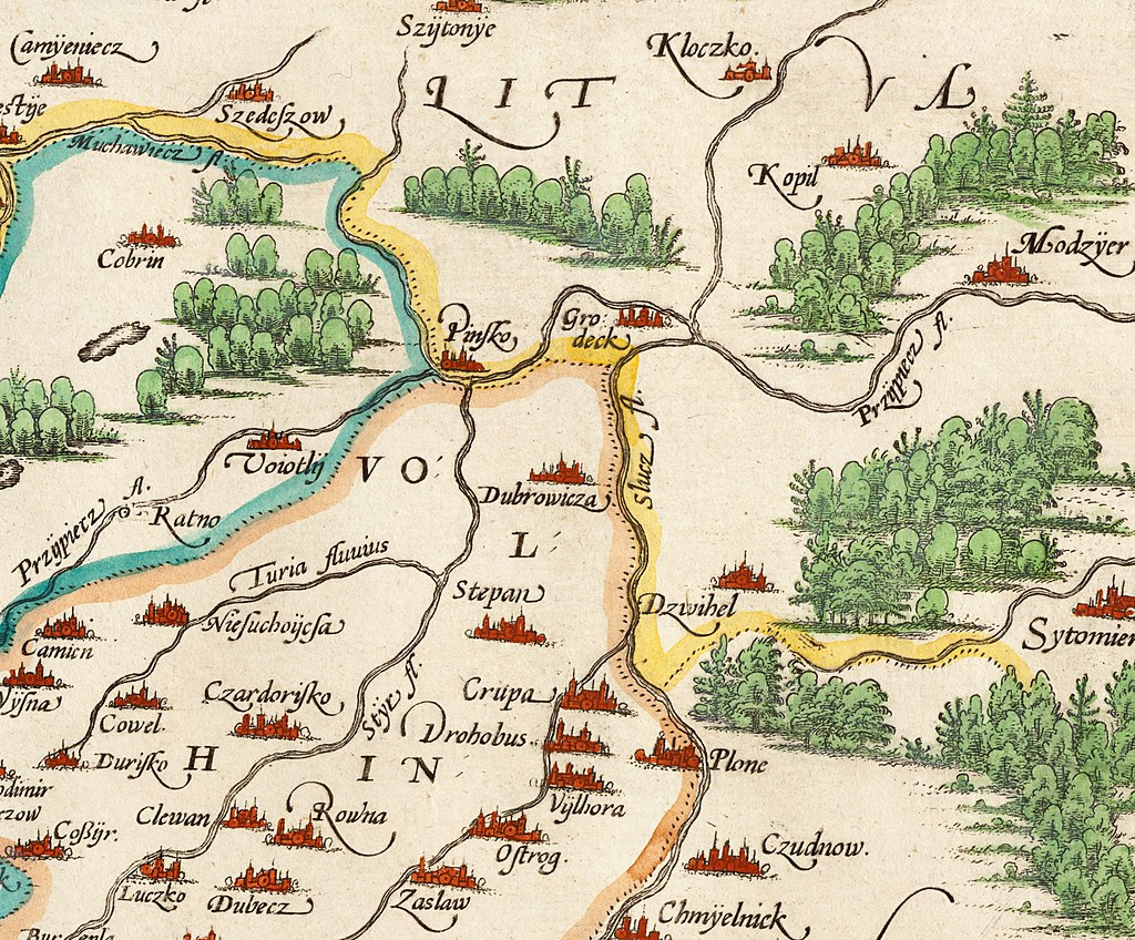
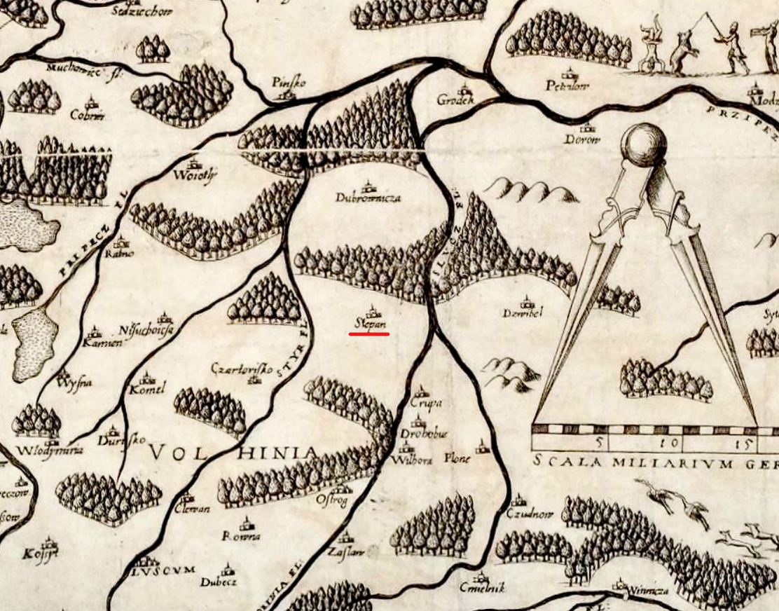
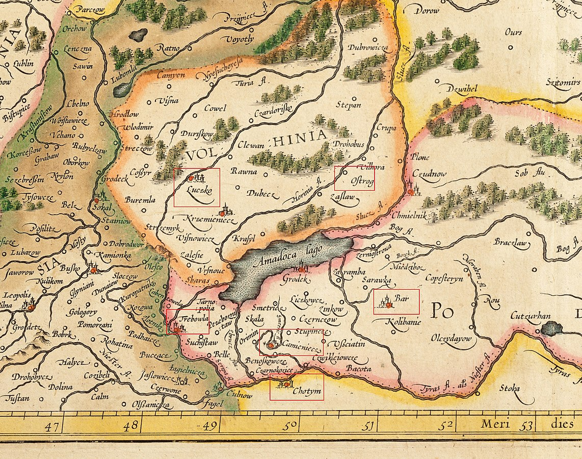
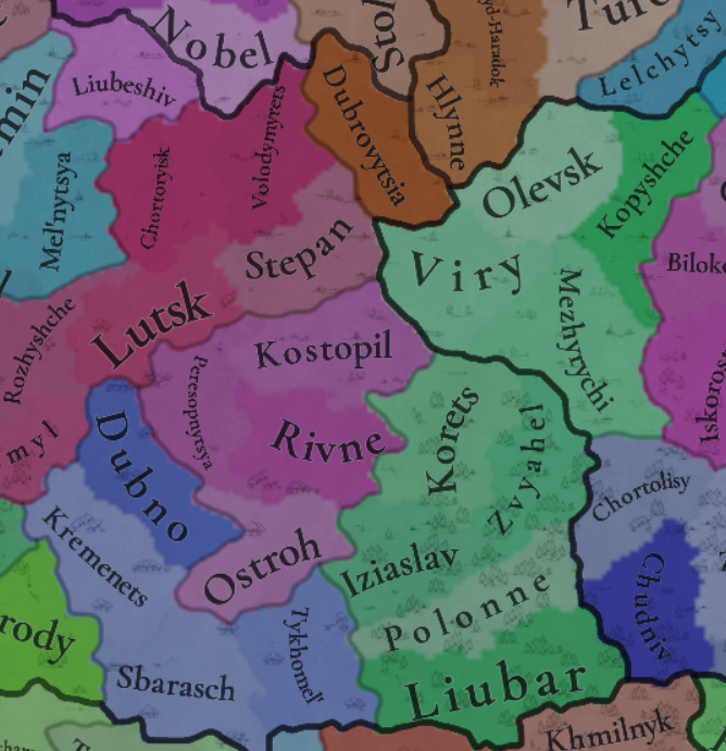
So what I want to suggest is a little map change, but if this is not an option then name change of the province would also work. The area i want to be change is my homeland, and the reason I want to suggest some changes because the town named Volodymyrets was just a small settlement at that time (some people already mentioned this here). On the other hand there was another important town Stepan (Polish: Stepań) (which in some sources is even mentioned as important trade node between Ruthenian and Lithuanian lands) that was founded in 1290. Importance of this town showed also that during the Great Northern War the Swedish army stopped in the town and even Charles XII was there for a few days and attended local Catholic church after Grodno was occupied by Sweden (Source: БачинськийВ. М., Гром В. М., Цибульський В. І. «Волинь у XVI — XVIII ст.», Рівне, 1996). Also there are dozens of old maps with this town, some of them I attached below.

1746732635578.png

1554 Gerardus Mercator Map of Europe
1746734177767.png

Poloniae Finitimarumque locorum descriptio Auctore Wencelslao Godreccio, 1580
1746734196737.png

Andrea Pograbio. Partis Sarmatiae Europae, quae Sigismundo Augusto regi Poloniae potentissimo subiacet nova descriptio. 1570
1746734829983.png

Gerardus Mercator. Lithvania. 1595
1746735043618.png

You can clearly see that Volodymyrets was not shown on all of these maps, while Stepan was.
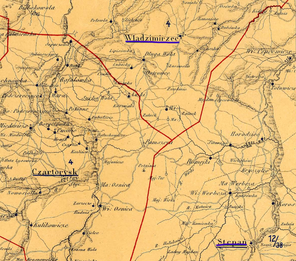
And much more bigger and detailed map I have found in the archive (this one is XVIIth century):
1746735378205.png

Here you can finally see Volodymyrets (on the map it is Wladzimierzec) and compare its size to other local towns.
Another thing about forestry: while with the marshes everything is correct, there should definitely be forests and not woods for this region. The Polesia region, with its dense forests and impassable marshes, was one of the most remote places from the civilization in Europe up to the mid 20th century.

Last thing - resources. Well, the best option is definetely amber (as other people mentioned here) and I can confirm it as someone who lives in this region. You could ask why. Well, unfortunately, "amber rush"/"amber wars" (this region is rich in amber, was... a few years ago) and uncontrolled mining have become more common in recent years and it has negative impact on the nature. Other possible resources are clay, sturdy grains and lumber.

It took me quite a bit time to write this and recall all these things. You could also make some other changes to the map if you would like based on the map sources I've provided. In any case, I am open to discussion and and will answer question if there will be. I don't know if this is going to be implemented into the game, but I wanted to share it, I like learning history of my homeland and sometimes it is worth sharing my knowledge with otheres and even contribute to a big project like this. Thank you for reading!

PS. sorry for any grammar mistakes : )
 
  • 1Like
  • 1
Reactions:
Hi, I may be a bit (too) late with a suggestion but I just want to propose small change that could be implemented and make the map more accurate. And it also better late then never : )

So what I want to suggest is a little map change, but if this is not an option then name change of the province would also work. The area i want to be change is my homeland, and the reason I want to suggest some changes because the town named Volodymyrets was just a small settlement at that time (some people already mentioned this here). On the other hand there was another important town Stepan (Polish: Stepań) (which in some sources is even mentioned as important trade node between Ruthenian and Lithuanian lands) that was founded in 1290. Importance of this town showed also that during the Great Northern War the Swedish army stopped in the town and even Charles XII was there for a few days and attended local Catholic church after Grodno was occupied by Sweden (Source: БачинськийВ. М., Гром В. М., Цибульський В. І. «Волинь у XVI — XVIII ст.», Рівне, 1996). Also there are dozens of old maps with this town, some of them I attached below.

View attachment 1293332
1554 Gerardus Mercator Map of Europe
View attachment 1293354
Poloniae Finitimarumque locorum descriptio Auctore Wencelslao Godreccio, 1580
View attachment 1293355
Andrea Pograbio. Partis Sarmatiae Europae, quae Sigismundo Augusto regi Poloniae potentissimo subiacet nova descriptio. 1570
View attachment 1293367
Gerardus Mercator. Lithvania. 1595
View attachment 1293374
You can clearly see that Volodymyrets was not shown on all of these maps, while Stepan was.
And much more bigger and detailed map I have found in the archive (this one is XVIIth century):
View attachment 1293381
Here you can finally see Volodymyrets (on the map it is Wladzimierzec) and compare its size to other local towns.
Another thing about forestry: while with the marshes everything is correct, there should definitely be forests and not woods for this region. The Polesia region, with its dense forests and impassable marshes, was one of the most remote places from the civilization in Europe up to the mid 20th century.

Last thing - resources. Well, the best option is definetely amber (as other people mentioned here) and I can confirm it as someone who lives in this region. You could ask why. Well, unfortunately, "amber rush"/"amber wars" (this region is rich in amber, was... a few years ago) and uncontrolled mining have become more common in recent years and it has negative impact on the nature. Other possible resources are clay, sturdy grains and lumber.

It took me quite a bit time to write this and recall all these things. You could also make some other changes to the map if you would like based on the map sources I've provided. In any case, I am open to discussion and and will answer question if there will be. I don't know if this is going to be implemented into the game, but I wanted to share it, I like learning history of my homeland and sometimes it is worth sharing my knowledge with otheres and even contribute to a big project like this. Thank you for reading!

PS. sorry for any grammar mistakes : )
You comment a very old thread, the map has been updated since that time:
1746737995658.png
 
  • 4Like
Reactions:
You comment a very old thread, the map has been updated since that time:
View attachment 1293428
I haven't seen the new post of the map, so that is why I wrote all this. I just feel that I wasted my time writing this since it is already on the map.
But the the new version of the map is much better than previous one, and the province I wanted is finally there :)
 
  • 1Like
  • 1
Reactions:
Absolutely not. This map shows when Ostsiedlung STARTED, not when Germanization was completed. There is a reason why in 1764 Frederick II was banning speaking Polish in Wrocław/Breslau schools and government offices. Mass Germanization and mass colonization of Silesia started with Prussian conquest. In 1337 all of Silesia is majority Polish speaking. Before 1324 German did not even appear in any letters or documents in Wrocław/Breslau. German became more widely spoken than Polish in parts of Lower SIlesia south of Oder in late 15th, early 16th century, so like 150 years after the game started.
Thank you for your reply, the map shows the start, that is right. which for example in Silesia was in the 13. Century, especially after the mongol invasion. The Ostsiedlung ended around 1400, while it was slowing down after 1300. The right map shows the population around 1400 and shows already at least a large german majority in Western Silesia and south to the Oder-River. It is probably better as it shows also mixed areas.
 

Attachments

  • Bevölkerung_Mitteleuropas_um_895.jpg
    Bevölkerung_Mitteleuropas_um_895.jpg
    2,4 MB · Views: 0
  • 2
Reactions:
It's really a shame that the devs decided to give aukstatian culture to braslaw and grodno despite there being to etymological or historical claim to their presense in the region, both towns were created by the kyivan rus and were border towns to the balts. If anything grodno should have a yotvingian presence, not an aukstatian one.
 
  • 2
  • 2
Reactions:
As Jotvingiai were not added, they just gave their lands to Aukštaičiai. And regarding the other one, I believe it's the same situation as with Prusians, where it will be dominated by Germans, while Balts will be the minority though Balts should have been the majority by that year still. But do to missing data on population, you can't really know. As there are multiple Baltic hydronyms up to Kursk and Kiev, so even though the city was founded by the Rus for trading the area may have mostly inhabited by the balts.
 
  • 1Like
Reactions:
As Jotvingiai were not added, they just gave their lands to Aukštaičiai. And regarding the other one, I believe it's the same situation as with Prusians, where it will be dominated by Germans, while Balts will be the minority though Balts should have been the majority by that year still. But do to missing data on population, you can't really know. As there are multiple Baltic hydronyms up to Kursk and Kiev, so even though the city was founded by the Rus for trading the area may have mostly inhabited by the balts.
Yes, there were baltic hydronyms up to kursk and kyiv because only balts inhabited that area until the 6-8th century when the slavs settled these areas, After this the balts in those areas assimilated into slavic culture and integrated into the tribes of the krivichi, dregovichi, etc. The towns of braslaw and its surroudning areas were controlled by polotsk or the kyivan rus for at least 300 years and there is no reason to believe that the balts would not have assimilated by this time. For grodno, the city was most definetely culturally polesian as there was an orthodox church built in the year 1183 and it was built by the kyivan rus. Maybe there were some yotvingian tribes in the rural areas however as you mentioned, there's not much data on population so based off this there should still be a polesian majority with a significant yotvingian or/and aukstatian minority or vice versa. I'm pretty sure this is how it was anyways until they changed it for some reason.
 
  • 1
Reactions: