• We have updated our Community Code of Conduct. Please read through the new rules for the forum that are an integral part of Paradox Interactive’s User Agreement.

Tinto Maps #8 - 28th of June 2024 - Russia

Hello, and welcome one more week to Tinto Maps! This week we’ll be taking a look at Russia!

As an introductory note, we’re just considering today the ‘Russian core’, which in 1337 comprised the different Russian Principalities, as far as the White Sea to the north, and the Ural Mountains to the east. The lands that would later be incorporated into the Russian Empire will be covered in future Tinto Maps (otherwise, we would have to cover like… 1/8th? of the land mass in just one DD).

Countries
Countries.png

Russia is divided into several Principalities in 1337. The dominant one probably is Muscovy, as its Grand Prince, Ivan I Danilovich ‘Kalita’ (‘Moneybag’) is also Prince of Nizhny Novgorod and Kostroma, and of Novgorod (by election, in this case). He also holds the title of Grand Prince of Vladimir, bestowed by the Khan of the Golden Horde, which makes him the ruler enforcing the ‘Tatar Yoke’ over other Russian Principalities (which in our game is represented through an IO; the coloring of the different countries is different tones of yellow as they are tributaries of the Yoke). The other main power in the region is the Grand Republic of Novgorod, with a completely different institutional structure, that allows them to pick their rulers. Their power comes from being the main trading power between the Baltic Sea and the Russian region, and it’s the overlord of two border countries, the Principality of Pskov, and the County of Oreshek, a buffer country in Karelia, as agreed with Sweden after a recent war. Several lands to the north and east are not owned by any country. As a final note, you may also see that Lithuania is the overlord of some of the principalities, some of them directly through Gediminid rulers (Polotsk or Vitebsk), while other over Rurikovich rulers (Smolensk or Rzhev).

Muscovy.png

Tatar Yoke.png

The starting diplomatic of Muscovy and the Tatar Yoke IO, for the sake of clarity.

Dynasties
Dynasties.png

Several branches of the House of Rurik rule over the Russian lands. Fun fact: we have 18 different branches portrayed in the game. The exceptions are a few principalities, and the ruler of Karelia, Prince Narimantas of the Lithuanian Gediminids. Also, the 'Cherdyn' and 'Vyatka' are randomly assigned dynasties, as we haven't been able to get the data for those countries on 1337.

Locations
Locations.png

We’re showing a less detailed region this week because, well, Russia is big. Feel free to ask for more detailed screenshots of specific areas, and I’ll try to provide them. We’re also showing some parts of the Steppe, Finland, and Kola, because of the scale of the map; take them as ‘unavoidable spoilers’, as we’ll talk more in-depth about them in future Tinto Maps.

Provinces
Provinces.png

The provinces of Russia. As usual, suggestions are welcomed!

Terrain
Climate.png

Topography.png

Vegetation.png

Terrain map modes. As discussed in previous Tinto Maps, we’ll read carefully your feedback, as we have plenty of room to polish them!

Cultures
Cultures.png

Cultures! As in other regions, we decided to have three different cultures in the Russian region, Novgorodian, Muscovite, and Severian. The design here is different than in the Ruthenian region, because Russia was more politically divided in the High Middle Ages, and would later be more culturally unified later on, while in Ruthenia, the situation would be the opposite. In any case, the four of them are East Slavic cultures, and we're open to feedback, of course. Apart from that, there are a bunch of different cultures bordering the region: Karelian, Pomor, Komi, Udmurt, etc. We might add some more minorities of these cultures, in the feedback pass after this DD. Also, take into account that the minorities over the Tatar lands (currently under the Kazani and Mishary cultures) are not yet done.

Religions
Religion.png

Eastern Orthodoxy is dominant in the region, although there are other religions in the area, as well; take ‘Animist’, ‘Tengrist’, and ‘Shamanist’ as wide categories, as we’d like to add a bit more granularity for them (although that will come later this year, don’t expect them to be added in the coming Tinto Maps, but maybe on the later ones). We’ve already seen some posts asking about Slavic Paganism; up until now, we’ve considered the Russian people to be Christianized, even if it was a more or less superficial process. If you’d like us to add this religion and some percentage of the population adhering to it, then I’d ask you for specific sources that could help us portray it (so, isolated references to it being followed here or there won’t be helpful, while academic sources saying ‘up to X% of the population was following Slavic rites’ might very much be).

Raw Materials
Raw Materials.png

Quite different resources to other regions previously shown, with plenty of Lumber, Fur, and Wild Game in this region. I’ve also extended a bit the screenshot to the east, so you can see the mineral richnesses of the Ural Mountains, with plenty of locations with Copper, Iron, Gold, and Lead, making it quite juicy to colonize.

Markets
Markets.png

The counter to the richness of the natural resources of the region is its integration into the different markets, which at the start of the game are centered around Novgorod, Moscow, and Kazan. Fully exploiting the economic possibilities of Russia will therefore require effort and patience.

Country and Location population
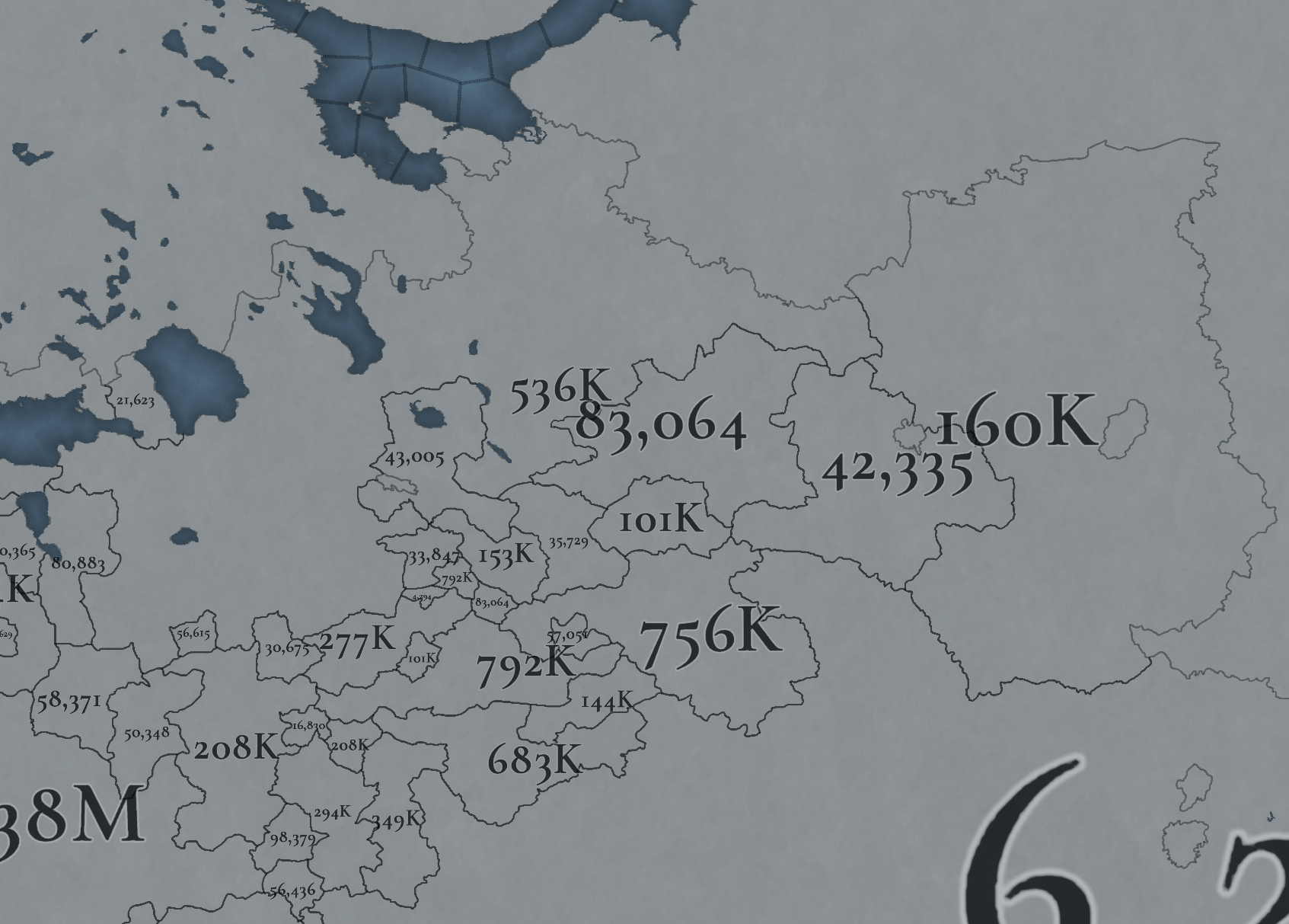
Country Population.png

Location Population SW.png

Location Population SE.png


Location Population NE.png

Location Population NW.png

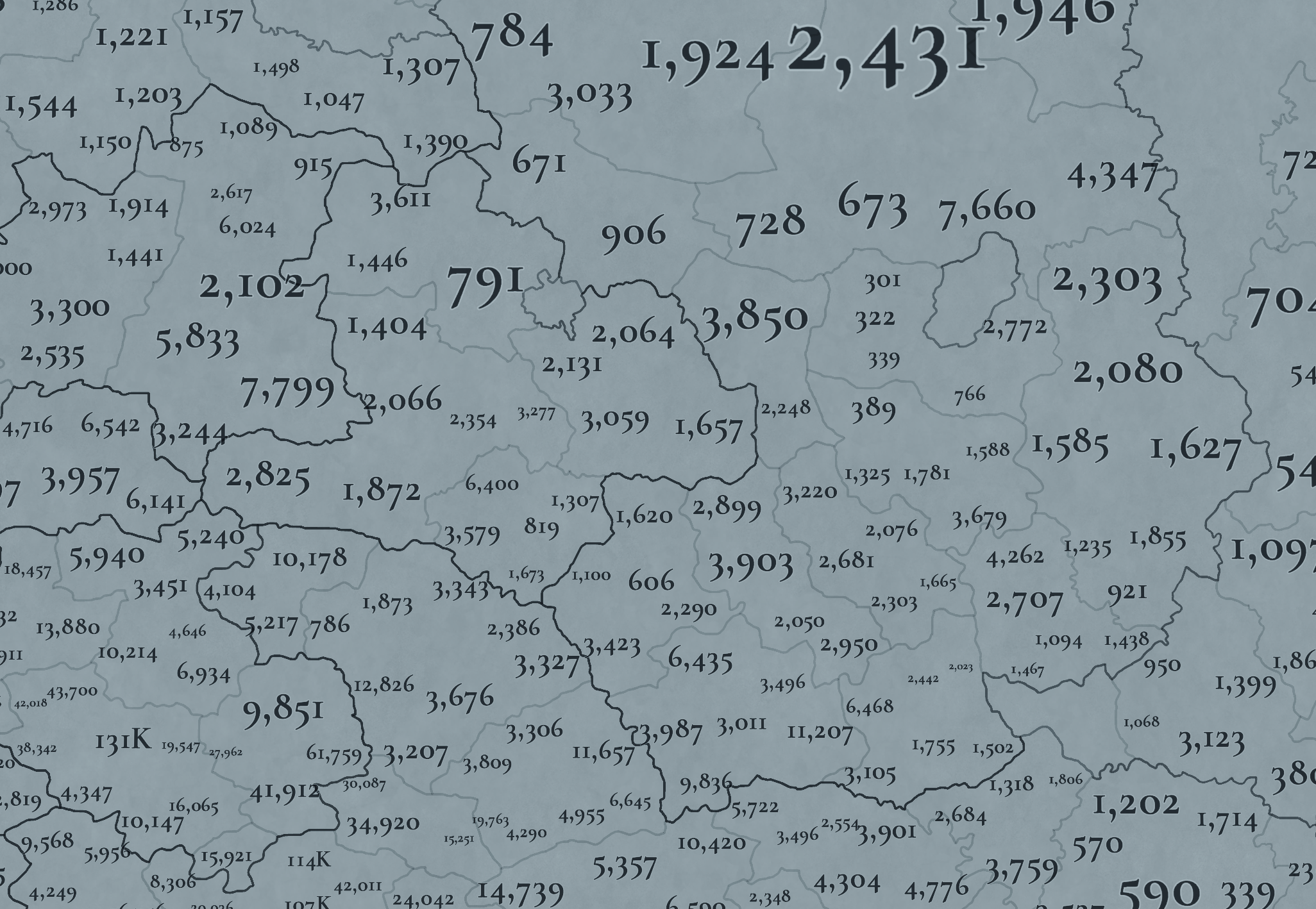
Not many people inhabit the Russian core, approximately 6M in total. This poses a series of challenges regarding the expansion of any Russian country. Also, we've divided into 4 different maps of the location population of the region, to make it possible to visualize. A side note: you might note that the population of NW Novgorod and Karelia is calculated a bit differently. That's because Johan took care of drawing the Scandinavian map in an early stage of development, and the Content Design team took over the rest of Russia at a later stage when we had already refined a bit more our population calculation methods. This means that when we do the feedback pass after this Tinto Maps, in a few weeks, we'll homogenize the style, as well.

And this is all for today! We hope that you’ll find it interesting, and give us great feedback! Next week we’re traveling to Carpathia and the Balkans! See you!
 
  • 158Like
  • 67Love
  • 6
  • 6
  • 5
Reactions:
Good points all around. However the range of the culture is based on the archaeological sites attributed to the Chiyalik culture. While they suffered heavily under the Mongol expansion, they were apparently integrated into the Mongol society as evidenced by Golden Horde coinage being found alongside Chiyalik ceramics and their own burial types distinct from the Golden Horde ones. They may have even converted to Islam at some point before their assimilation into Bashkirs under the rule of the Golden Horde. Overall the culture seems to have survived along the Belaya river all the way to the 15th century.
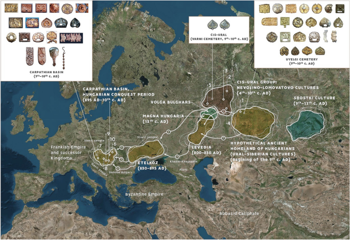
Additional good points there, I'd recommend checking out "Tracing genetic connections of ancient Hungarians to the 6th-14th century populations of the Volga-Ural Region" by Bea Szeifert for additional information and other interesting maps and info about some of the artifacts. It does appear that the culture is at least defined to the 15th century, but following the Mongol conquests, there was a shift in the culture towards Islam, evident in their burial customs. I guess the question here is when does a culture officially end? After rereading this article I think it is right to include them as a culture in the game and around the limits of the map you described, but at the start date of the game there appears to be a shift towards pagan/Islamic syncretism, as opposed to the older Uralic Shamanism that would have been present at the time of Friar Julian's expedition. Good points all around.
 
  • 2
Reactions:
Cool, is the same for that tag named "Kas." Situated between Mologa and Tver?
That's the Principality of Kashin, which is a vassal of the Principality of Tver, which is a tributary of the Golden Horde.
 
  • 23Like
Reactions:
Thank you for making the Solovetski islands an independent location. Can't wait to make it the capital of my Russian empire on my first run.

One small q tho, the location appears uncolonized, with 94 dudes living inside, yet it's ethnically Russian? Is that an oversight, or supposed to represent something? Because if it is supposed to represent actual Russians living there, wouldn't it be better off being owned by Novgorod? Or even an independent (presumably, theocratic) tag?
 
  • 3Like
Reactions:
can RGOs change in this game? Because if they can, I really don't see a reason for wheat to be present in the steppe horde territory, since nomads, you know, generally didn't do seasonal agriculture
 
  • 2Like
  • 1
Reactions:
I'm a bit hesitant as to this for two reasons, but am interested to see your thoughts. Firstly, I'm not sure if they can fully be considered Magyars, but they were certainly a Uralic tribe that had some previous connections to the migrating Magyars from archeological and genetic evidence. Culturally however they remained much more nomadic and had a more tribal structure and culture, as noted in Friar Julian's account of his travels to Magna Hungaria. Perhaps labeling them as Chiyalik is a more proper term given these differences, but this culture would die out and be assimilated into the Bashkirs of the area. They can however, still be considered Hungarian/magyar speaking, since PC seems to have some language component alluded to, and given Friar Julian's describing of the language as mutually intelligible to Hungarian at the time.

The second concern is the limits you show them on the map, since by Friar Julian's second journey, he reported that the eastern Hungarians had been wiped out and he couldn't find them as a result of the encroaching Mongols. As such I believe the limits of the culture should be smaller, and already partially assimilated with the Bashkirs.
culture=/=genetics=/=language=/=physiogynomy. with that being said do we have any real sources talking about magyar-permian connection in the timespan of the game?

As far as I'm concerned even in terms of language there's a good chance most hungarians who'd migrated into the danubian plain 4 centuries prior only spoke the language, but were not necesserily Khanty themselves. And hungarian culture by 1337 was certainly quite different from that of the near-uralic ugric tribesmen

Honestly this is like saying that Finns are actually Chinese all along because of the haplogroup and possible language connections
 
  • 3
  • 2Like
Reactions:
I've seen some kinda mistakes in naming provinces/states, and will try to explain where and why
Most of provinces named by nouns, like Orel (city of Orel), but some by adj (it's right to do if you are naming oblast (state)), but naming some of states by adj and some by nouns looks kinda weird. for example, Sorochinskaya state is adj, so if naming everything as nouns better to name just Sorochinsk.

To be clear, better to look at every name which ended with -aya, -skaya, not -oe, -noe. It's adj too, but kinda specific and using them is normal. If you can provide full map or just list of names I can look through and help with it, thank you for your work!
 
It's a convention, one of the two possible ways of naming the country: https://en.wikipedia.org/wiki/Principality_of_Moscow . BTW, although it's not displayed in the map, the full dynamic country name is 'Grand Principality of Muscovy'.

But we're open to feedback, if the community thinks that Moscow is more appropriate as the English form than Muscovy.
Muscovy helps to differentiate between the tag, the province and the region, and consistent with eu4 so I'd say keep it
 
  • 7
  • 3Like
  • 2
Reactions:
You find notion that there was single unified culture on lands 1000 km long more historically accurate than what was presented? In medieval world where neighboring village can speak different dialect because fastest way for peasant to travel is his own two legs and there is not much in communication department?
Absolutely. Slavic languages, for example, in general have been known to be remarkable similar owing to their very late separation and rapid spread across eastern europe. I think the consensus is that all slavic languages (that is, western, southern and eastern groups) did not separate until ~10th century A.D.

Also, you know, England's been given one single culture for all of its anglo-saxon pops. I'd argue that the differences in terms of culture and the way of life between the residents of Kiev and Novgorod than betwen the residents of Northumbria and the isle of wight until after ~16th century. I.e. some hundred years+ of domination of Lithuanians/Poles in the latter that broke the bonds of what was previously a singular, if heavily decentralized realm of the Kievan Rus'
 
  • 8
  • 4
Reactions:
Regarding Sokol (east of Vologda, which is southmost part of eastern Novgorod Republic, east of Beloozero) - the town was only founded in 1932. According to the wiki, it had a village in the same place called Sokolovo, first named in 1615 according to some documents, which I was unable to find. It was called after somebody named Sokol ("falcon").
(history section, first sentence)
This date and name are also mentioned on other websites related to region's history, but still no documents.

Anyway, the name is anachronistic, even if we take Sokolovo from 1615. The town itself nowadays is very small, about 40k people. I can only assume that the population in 1337 was negligible. I would like it to be renamed to something else, main Sukhona (after the river), Kubenskoe (after the lake Kubenskoe, which fits nicely with Zaozerye (meaning "beyond the lake") location), or simply Sokolovo (I'm sure you've noticed how naming villages in the region goes).

I've also found this map, dated 1785, which has no towns or villages along the river (where modern Sokol is) marked, but it has a name for the river - Rybinsnkaya Sukhona (meaning Sukhona belonging to Rybinsk)
http://www.etomesto.ru/map-vologda_vologodskaya-gub-1785/?x=40.105248&y=59.451262

Also, Sokol mentioned, lets fucking gooooooooo!

Edit:

Regarding Tsareva, north-east of Sokol - I have a feeling that it is also anachronistic. The subdivisions are *very* small and I do not envy the people that have to work on this region. It is simply not as populated as Europe and has much less history. Still, Tsareva means "belonging to a tsar/tzar/zar" (speculation on my part, there are no evidence that I could find), which would be anachronistic, since the first tzar in Russia was Ivan IV Grozny (the Terrible), who's been crowned in 1547, all others before were princes (or knyaz singular, knyazia plural). I am almost certain that the river was named after some tzar. Sadly, the information is very sparse, I only found some topographical/hydrological data, no dates or previous names. There are a lot of villages nearby, but they are *tiny* tiny, we're talking dozens of people at best. What I did found is that the local orthodox church in Tsareva village was built in 1779 (https://sobory.ru/article/?object=03693).

I dug around some more, but there are a lot of small villages there with not much history or data at all. Still, I belive that the name alone warrants reconsideration.

Here is the oldest map I could find, 1785 as well. The marker is right on top of the Tsareva river, which is also written right above it. There are two smaller rivers that form Tsareva - Tafta (Тафта) to the west and Vojbal (Вожбал) to the north, these are black lines. There are three places marked by stars between them - Kudrinskoye (Кудринское), Sergeevskoye (Сергеевское, but I can be mistaken about the first "e" letter), and Solеnogorskoye (Соленогорское). The second star is circled, and so is Totma, the big city to the east. I would assume this means that it is sizable, but I can't find it on the map. The only similar sounding place has a whooping population of 20 people. There is also a village of Krasniy Bor (Красный Бор), 300 people, located right between three rivers - Tafta, Vojbal and Tsareva (https://ru.wikipedia.org/wiki/Красный_Бор_(Вологодская_область) plus https://yandex.ru/maps/geo/posyolok_krasny_bor/53145575/?ll=42.266485,59.870604&z=13.03). I think it would be a better fit - it means "red fir forest", but, again, lack of data.

As a sidenote, I'd recommend you use 2GIS maps or Yandex maps, preferably both. Google lacks details, since the former two are russian-made-for-russians.

I can't really pinpoint you to an answer, but I can tell you which doesn't quite fit. Still, hope it will be of help!
Location-names should always be castles/villages/towns/cities, not rivers or other geographical entities.
 
1. Probably yes; I guess that @SulphurAeron will help us with that. :)

1719598686058.png


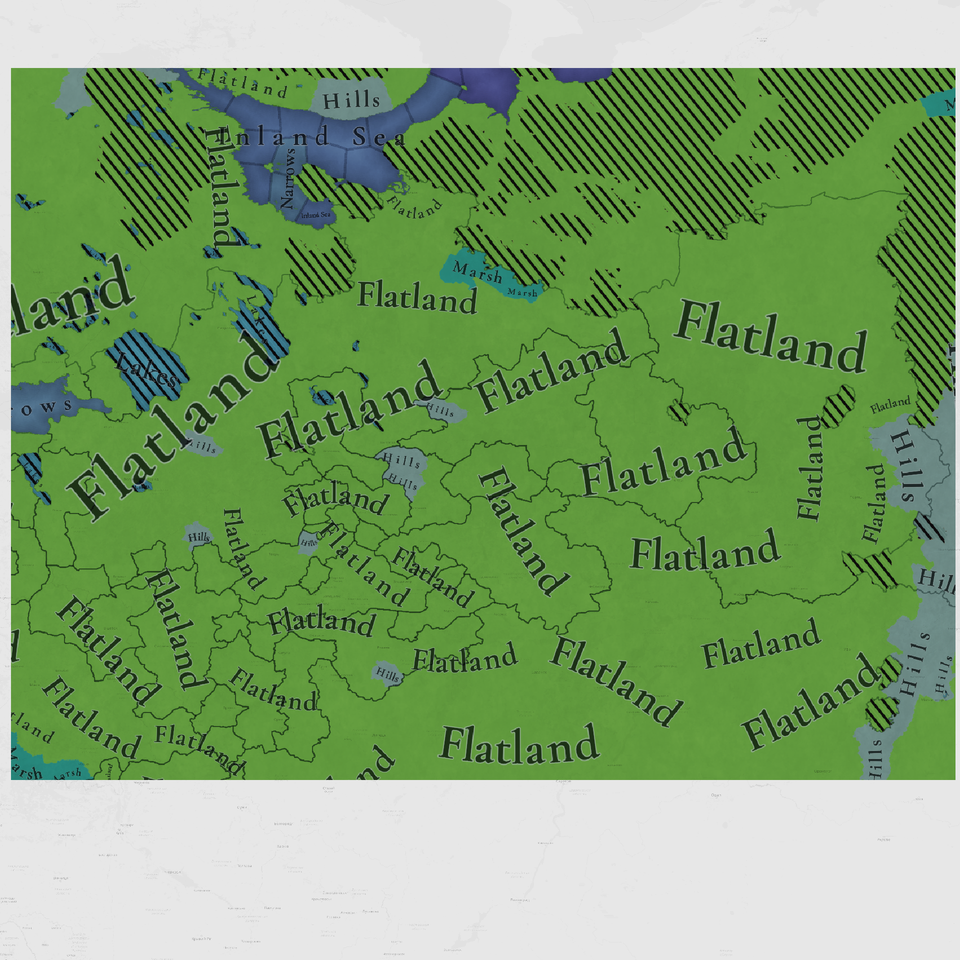
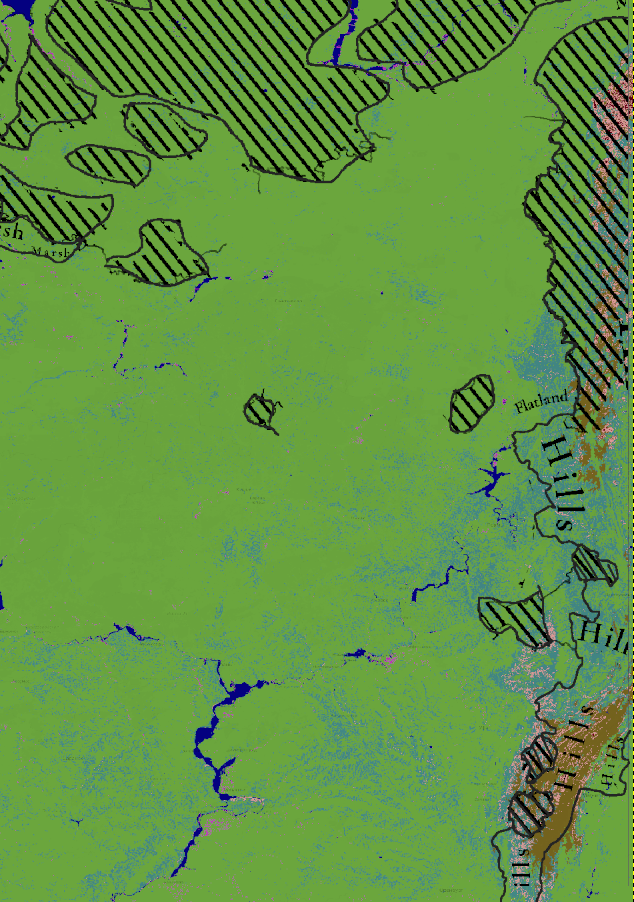
Another week, another climate and topography analysis!
For how I made this analysis, see the links in my signature.

TL;DR:
- I largely agree with climate (Boreal climate being represented as accessible Arctic, true Arctic climate is considered impassable)
- Hills in Muscovy-Novgorod region need to be reworked, and a few shifts in the Urals
- Marshes are largely correct, with only a few additions I'd suggest

1. Climate
- Arctic climate should expand across the rest of the Ural mountain range.
- Arctic should shift somewhat northwards across the whole West-East line
- Ladoga - Korchino axis should be designated Arctic in this time period
Climate according to TintoClimate 1901-1930 reclassified to Tinto's categoriesClimate 1901-1930 - 30 Köppen Categories
ClimateTinto.png
ClimateSulphur_8cats.png
ClimateRaw_Labeled.png
ClimateTintoEditCut.png

White line: my suggested design
White dots: current design

2. Topography

Russia has almost no hills, and the more 'rugged' parts of the terrain are towards the south and the Urals, although these are also to be considered very mild
Topography according to TintoTopography according to TRI reclassificationTopography according to linear DEM (0-1500 m)Non-linear DEM exaggerating lower topographic features (dark gray/blue = 0m, pale green = 300m)
Topography_Tinto.png
Topography_Sulphur.png
Topography_SulphurDEM.png
Topography_HiresLowTopo.png
Note the marshes in the Batis region towards the South of Kazan, *just* off-screen from the tinto maps!

MARSHES:
Add marshes to:
Yagnitsa and potentially Ust-Sheksna (Mologa province),
One of: Kholm, Dolchinyo, Voronich (Kholm)
Kaduy (Beloozero),
Belye Kresty (Ustyuzhna),
Pomorye/Arkhangelsk (Kholmogory)
Koyda (Koyda).

For just off-screen: add marshes to Batis region of modern Kazachstan (see spoiler above)
Otherwise no comments and great job on removing the modern water reservoirs!

HILLS
Why there are hills in Novgorod-Muscovy are a bit of a mystery to me.
Regional topography is VERY flat, and hills were placed on spots with nearly no topography (e.g. "Kimica"? East of Tver).
I honestly don't think hills should be a factor for this part of Russia (not even rolling hills)

The more 'rugged' part of the terrain is towards the south (off-screen), although these are also to be considered rather mild rolling hills.

The more 'rugged' topography is found in the the Urals, but ruggedness here should be more used in claimte sense rather than actual terrain.
For the sake of variety and relative importance, the criteria for 'mountains', 'hills' and 'plateau' could be reconsidered in this colder landscape.

1719607027566.png
1719607036819.png
<- Remove all hills in the Novgorod-Muscovy region.
1719606737409.png
1719606714240.png
1719606836802.png
1719607872085.png
Remove topographic wastelands near Kobra and Usolye. Remove the wasteland of the Ufa provinceSquinting your eyes you could add some other hilly parts, but note that the topography is all rather low (below 300 metres above sea level)How the topography map could look like when downgrading local classifications for topography.^ overlapped with the provinces

Next week we’re traveling to Carpathia and the Balkans! See you!
Uh-oh. *cracks knuckles*
 
Last edited:
  • 14Love
  • 10Like
  • 4
  • 3Haha
  • 1
Reactions:
culture=/=genetics=/=language=/=physiogynomy. with that being said do we have any real sources talking about magyar-permian connection in the timespan of the game?

As far as I'm concerned even in terms of language there's a good chance most hungarians who'd migrated into the danubian plain 4 centuries prior only spoke the language, but were not necesserily Khanty themselves. And hungarian culture by 1337 was certainly quite different from that of the near-uralic ugric tribesmen

Honestly this is like saying that Finns are actually Chinese all along because of the haplogroup and possible language connections
Well there's the historical account of Friar Julian which is perhaps the most weighing of the bunch but it is also corroborated by archaeological cultures. The migration of Magyars has been tracked archaeologically to correspond to the Iron Age Karayakupovo and Early Medieval Kushnarenkovo cultures in the Trans-Ural region. In the Cis-Ural region the Nevolino and Lomovatovo cultures also show connections to the aforementioned cultures and the migrating Magyars. Once the linguistic ancestors of Magyars left for the Pontic Steppes they left behind the progenitors of Chiyalik culture on the Ik and Belaya rivers. The culture is distinct from the other Turkic cultures such as Volga Bulgaria and there's clear evidence of Ugric tribes being integrated into the ancestors of Bashkirs before their ethnogenesis. So in short Chiyalik culture has quite a lot of evidence of being an Ugric Hungarian related culture in the Cis-Ural region.
This study confirms that the conquerors, and even their predecessors living in the region of the Volga and the Southern Urals, formed a composite, mixed population (6,9,22,51), and their genetic makeup was influenced by the base population of the area. The highlighted N1a1-M46 Y-chromosomal lineage shows a genetic link between the Kushnarenkovo and Chiyalik cultures, the conquerors and modern-day Hungarians, as well as the Volga-Ural region’s present-day groups (Bashkir, Tatar, Khanty and Mansi). This lineage is another piece of evidence that (at least a part of) the Hungarians came from the Volga-Ural region, from the territory of the Kushnarenkovo and Karayakupovo cultures, and it also shows the shared genetic history of the conquerors and the recent populations of the Volga-Ural region. The shared (and also chronologically and geographically debated) history of the Hungarians and Bashkirs can only be presented here from the aspect of the paternal lines, but it is also plausible on the mitochondrial level because a part of the Chiyalik population was most probably assimilated into the Bashkirs during the Middle Ages.
 
Last edited:
  • 4Like
  • 2
Reactions:
By trade centers
in 1337 a trade center in Bulgaria (Kazan)
inferior to the shopping center in Ukek (now Saratov)
Nizhny Novgorod was an important Trade Center by Volga
Tver - a small territory - was rich because of its role as a Trade Center between the waterways from Novgorod and the Volga.

Smolensk should be a trade center, because it served as a transshipment base between the Dvina (Baltic) and the Dnieper (Ukraine)
The Smolensk principality before the Mongols was one of the Richest (second after Kyiv in the number of stone buildings and Temples) precisely because of its Role in Trade. Because the lands of Smolensk are not very good for agriculture.
Smolensk was the first of the Russian principalities to conclude trade agreements with the Baltic Germans.
This is the reason for all the later wars for Smolensk, between Moscow and Vilna - control of river trade.
 
  • 2Like
Reactions:
Ethnography

The northern bank of the Volga above Nizhny Novgorod is the territory of the Mari. The Mari also made up a significant part of the population of the Galich (Dmitrov) principalities. Their mentions among the region's elite disappear from chronicles only after the 15th century.
in the 15th century, the Principality of Moscow (having annexed Nizhny Novgorod) waged long wars with the Mari on the northern bank of the Volga (the area of the Vetluga, Shakhunya, Sharanga rivers).

Individual crops need to be added
- Meshchera (Murom, Ryazan, Meshchera (Kasimov),
- and variants of Mordovian culture (Moksha, Erzya) in the territory east of Ryazan.
- The Chuvash are a separate culture from the Volga Tatars, although related, they also have three subtypes.
The Chuvash lived up to and including Penza.

- The Udmurts - where they now live on the map were more like the Mari; the Udmurts came to the region later. In the zone of the future Kazan Khanate on the northern bank of the Volga, it was the Mari who lived - the Cheremis.

The region from Beloozero and to the east is incorrect to do with the Novgorod culture - because it was historically settled not from Novgorod, but from the south - Vladimir.

You can add separate Smolensk culture (within the borders of the Smolensk principality of the 13th century) and Ryazan-Murom culture (similar to Smolensk within the borders of the 13th century).

It would be more correct to rename Moscow culture Vladimir culture, or Suzdal culture.
Because Moscow is still secondary in the title list, after Vladimir.

The borders of Novgorod and Smolensk (including the Principality of Smolensk near Lithuania) in 1337 need clarification.
Because before the arrival of the Mongols, the border between the Smolensk principality and Novgorod was further north than on the maps presented.

Another important factor is that until the 18th century there was no direct road between Vladimir and Moscow.
The route went through Pereyaslavl Zalessky and Yuryev Polsky.
For there were forests and swamps, sparsely populated.

In terms of population, your Russian north is too populated.
in 1337, this is a wasteland where Novgorodians collect tribute from the locals every 3 years.

Vyatka - first mentioned in chronicles in 1374. It's too early to be on the gaming map.
 
Last edited:
  • 7Like
Reactions:
I think the border between Arctic and Continental climates should be way farther north, especially towards the Urals

if you look at the 20th century climate map the border should be somewhere just north of Vologda, not 3 locations worth south of it https://upload.wikimedia.org/wikipedia/commons/9/90/Russia_Köppen_New_(Crimea_disputed).png

The problem is that this game will be basically set during the Little Ice Age, during which temperatures were much cooler than even the early 20th century.
 
  • 2Like
  • 1
Reactions: