• We have updated our Community Code of Conduct. Please read through the new rules for the forum that are an integral part of Paradox Interactive’s User Agreement.

Tinto Maps #8 - 28th of June 2024 - Russia

Hello, and welcome one more week to Tinto Maps! This week we’ll be taking a look at Russia!

As an introductory note, we’re just considering today the ‘Russian core’, which in 1337 comprised the different Russian Principalities, as far as the White Sea to the north, and the Ural Mountains to the east. The lands that would later be incorporated into the Russian Empire will be covered in future Tinto Maps (otherwise, we would have to cover like… 1/8th? of the land mass in just one DD).

Countries
Countries.png

Russia is divided into several Principalities in 1337. The dominant one probably is Muscovy, as its Grand Prince, Ivan I Danilovich ‘Kalita’ (‘Moneybag’) is also Prince of Nizhny Novgorod and Kostroma, and of Novgorod (by election, in this case). He also holds the title of Grand Prince of Vladimir, bestowed by the Khan of the Golden Horde, which makes him the ruler enforcing the ‘Tatar Yoke’ over other Russian Principalities (which in our game is represented through an IO; the coloring of the different countries is different tones of yellow as they are tributaries of the Yoke). The other main power in the region is the Grand Republic of Novgorod, with a completely different institutional structure, that allows them to pick their rulers. Their power comes from being the main trading power between the Baltic Sea and the Russian region, and it’s the overlord of two border countries, the Principality of Pskov, and the County of Oreshek, a buffer country in Karelia, as agreed with Sweden after a recent war. Several lands to the north and east are not owned by any country. As a final note, you may also see that Lithuania is the overlord of some of the principalities, some of them directly through Gediminid rulers (Polotsk or Vitebsk), while other over Rurikovich rulers (Smolensk or Rzhev).

Muscovy.png

Tatar Yoke.png

The starting diplomatic of Muscovy and the Tatar Yoke IO, for the sake of clarity.

Dynasties
Dynasties.png

Several branches of the House of Rurik rule over the Russian lands. Fun fact: we have 18 different branches portrayed in the game. The exceptions are a few principalities, and the ruler of Karelia, Prince Narimantas of the Lithuanian Gediminids. Also, the 'Cherdyn' and 'Vyatka' are randomly assigned dynasties, as we haven't been able to get the data for those countries on 1337.

Locations
Locations.png

We’re showing a less detailed region this week because, well, Russia is big. Feel free to ask for more detailed screenshots of specific areas, and I’ll try to provide them. We’re also showing some parts of the Steppe, Finland, and Kola, because of the scale of the map; take them as ‘unavoidable spoilers’, as we’ll talk more in-depth about them in future Tinto Maps.

Provinces
Provinces.png

The provinces of Russia. As usual, suggestions are welcomed!

Terrain
Climate.png

Topography.png

Vegetation.png

Terrain map modes. As discussed in previous Tinto Maps, we’ll read carefully your feedback, as we have plenty of room to polish them!

Cultures
Cultures.png

Cultures! As in other regions, we decided to have three different cultures in the Russian region, Novgorodian, Muscovite, and Severian. The design here is different than in the Ruthenian region, because Russia was more politically divided in the High Middle Ages, and would later be more culturally unified later on, while in Ruthenia, the situation would be the opposite. In any case, the four of them are East Slavic cultures, and we're open to feedback, of course. Apart from that, there are a bunch of different cultures bordering the region: Karelian, Pomor, Komi, Udmurt, etc. We might add some more minorities of these cultures, in the feedback pass after this DD. Also, take into account that the minorities over the Tatar lands (currently under the Kazani and Mishary cultures) are not yet done.

Religions
Religion.png

Eastern Orthodoxy is dominant in the region, although there are other religions in the area, as well; take ‘Animist’, ‘Tengrist’, and ‘Shamanist’ as wide categories, as we’d like to add a bit more granularity for them (although that will come later this year, don’t expect them to be added in the coming Tinto Maps, but maybe on the later ones). We’ve already seen some posts asking about Slavic Paganism; up until now, we’ve considered the Russian people to be Christianized, even if it was a more or less superficial process. If you’d like us to add this religion and some percentage of the population adhering to it, then I’d ask you for specific sources that could help us portray it (so, isolated references to it being followed here or there won’t be helpful, while academic sources saying ‘up to X% of the population was following Slavic rites’ might very much be).

Raw Materials
Raw Materials.png

Quite different resources to other regions previously shown, with plenty of Lumber, Fur, and Wild Game in this region. I’ve also extended a bit the screenshot to the east, so you can see the mineral richnesses of the Ural Mountains, with plenty of locations with Copper, Iron, Gold, and Lead, making it quite juicy to colonize.

Markets
Markets.png

The counter to the richness of the natural resources of the region is its integration into the different markets, which at the start of the game are centered around Novgorod, Moscow, and Kazan. Fully exploiting the economic possibilities of Russia will therefore require effort and patience.

Country and Location population
Country Population.png

Location Population SW.png

Location Population SE.png


Location Population NE.png

Location Population NW.png

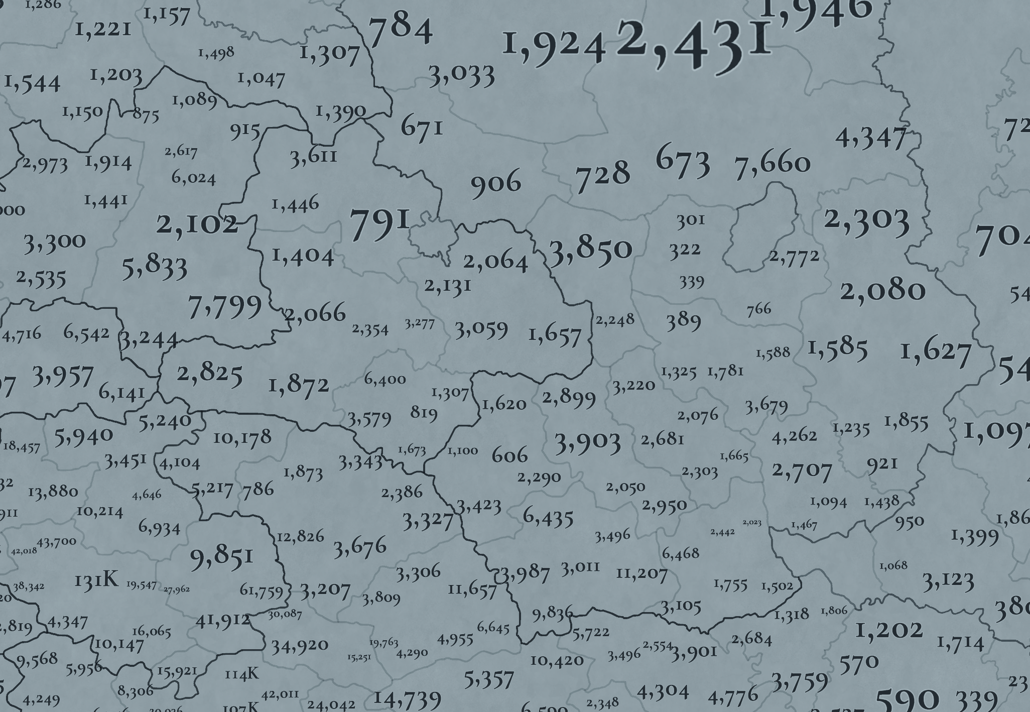
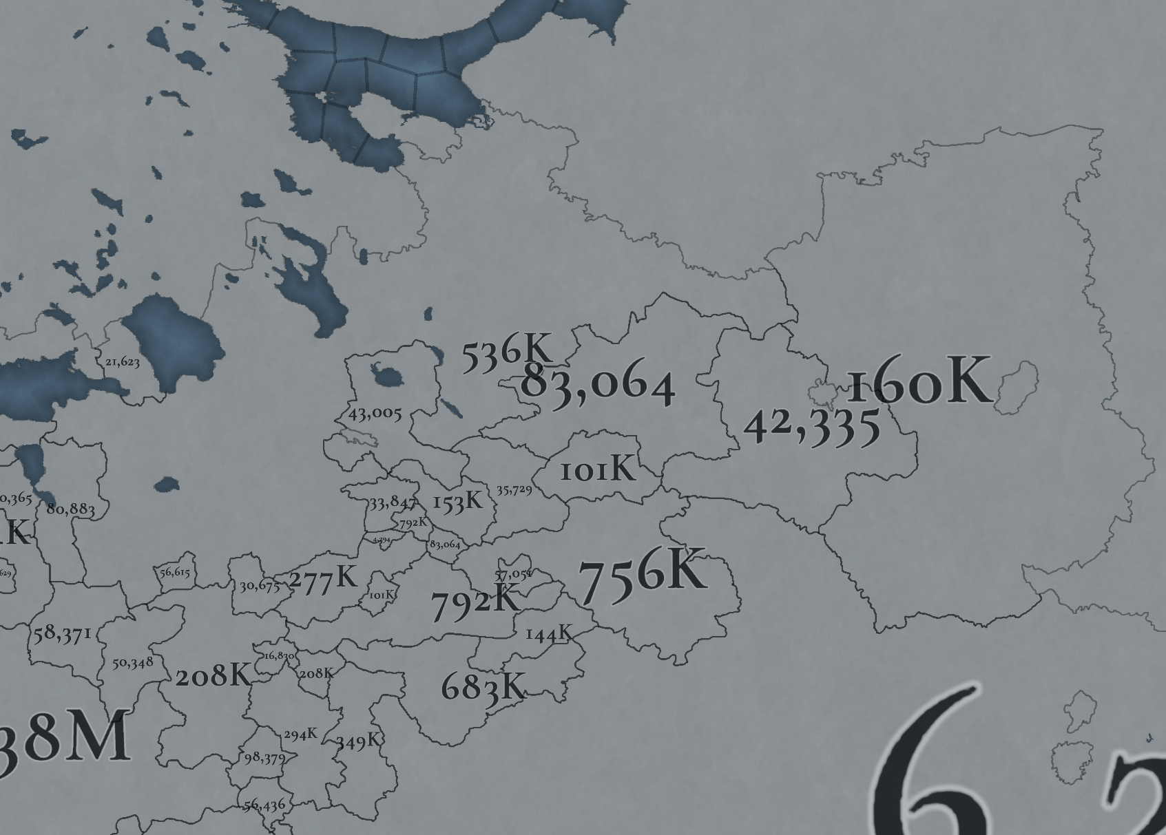
Not many people inhabit the Russian core, approximately 6M in total. This poses a series of challenges regarding the expansion of any Russian country. Also, we've divided into 4 different maps of the location population of the region, to make it possible to visualize. A side note: you might note that the population of NW Novgorod and Karelia is calculated a bit differently. That's because Johan took care of drawing the Scandinavian map in an early stage of development, and the Content Design team took over the rest of Russia at a later stage when we had already refined a bit more our population calculation methods. This means that when we do the feedback pass after this Tinto Maps, in a few weeks, we'll homogenize the style, as well.

And this is all for today! We hope that you’ll find it interesting, and give us great feedback! Next week we’re traveling to Carpathia and the Balkans! See you!
 
  • 158Like
  • 67Love
  • 6
  • 6
  • 5
Reactions:
The problem there is that Novgorod did not have ports in the full sense of the word.
Novgorod remained an extremely backward place in this sense.
Even stone fortresses (Koporye) were erected with great difficulty.
Cargo was transported by water to the sea and further to Livonia (both Russians and Germans). But there were no Ports. The first is not even a port, but a fortress controlling the mouth - Ivan-Gorod 1494.
Huh you are right, Novgorod didn't have any ports (very odd for a state using the sea for trade). Instead it used it's capital as the main base for trade. So it doesn't make much sense for Pskov to have it's border reach as far as the sea, unless if it was used as a sort of "march" by Novgorod in order to combat the Livonian order in the west, although Pskov didn't stay a vasal of Novgorod for very long
 
Last edited:
Huh you are right, Novgorod didn't have any ports (very odd for a state using naval trade to not have a port). Instead it used it's capital as the main base for trade. So it doesn't make much sense for Pskov to have it's border reach as far as the sea, unless if it was used as a sort of "march" by Novgorod in order to combat the Livonian order in the west, although Pskov didn't stay a vasal of Novgorod for very long
Novgorod was... not a trading republic in the Western sense of the word.
Novgorod was a principality with a very strong influence of the nobility (boyars)
These boyars owned Novgorod itself (settling artisans there) and vast parts of the Novgorod colonies, collecting tribute there.
These are the descendants of the Vikings with a characteristic way of thinking.
They collected raw materials (wax, honey, skins) and sold them with the least effort.
Aristocrats. not merchants
 
  • 2
  • 1Like
Reactions:
Huh you are right, Novgorod didn't have any ports (very odd for a state using the sea for trade). Instead it used it's capital as the main base for trade. So it doesn't make much sense for Pskov to have it's border reach as far as the sea, unless if it was used as a sort of "march" by Novgorod in order to combat the Livonian order in the west, although Pskov didn't stay a vasal of Novgorod for very long

Novgorod was not located on the sea, because Russian trade was mainly river-based. Neva trough Novgorod to Volga to Caspian sea, or Neva through Novgorod to Dnypro, there was also a way from Dvina to Dnypro, which is why Riga became so promiment under Russian control. First Russian ship was actually built for Caspian sea in Nizhny Novgorod, which is located on the Volga. Second ship was built in a village Dedinovo, because it was place of first European-style shipyard, and this village is located on the river Oka.

I hope Paradox would reflect this somehow, because it is really a core of everything going on with Russia and Eastern European plane in particular.
 
  • 4
  • 1Like
Reactions:
Novgorod was not located on the sea, because Russian trade was mainly river-based.

I hope Paradox would reflect this somehow, because it is really a core of everything going on with Russia and Eastern European plane in particular.
"Novgorod was not located on the sea" oh yes it definitely wasn't, I don't think it was even close to the sea.
1720627990211.png

(I wonder how many kilometers you need in order to reach the sea)

"because Russian trade was mainly river-based." True that, I think it was for all Eastern Slavic states thought, not just the Russian ones.
 
  • 1Like
Reactions:
Will there be a way to unify Russian - if not East Slavic - cultures, or are we gonna be stuck with Severians, Novgorodians and Muscovites until 1836?

Also, if not, would we be stuck with Muscovites living everywhere Russia expands, again, from Kamchatka to Crimea, or will we have some kind of mechanic that would create new cultures where Russian (East Slavic) people expand? E.g. Southern Russians, (Russian) Siberians, etc?
Surely they have a way to unify them, i mean look at France...
 
  • 1Like
Reactions:
Yes, we consider Karelia part of this DD, so feedback is well received.
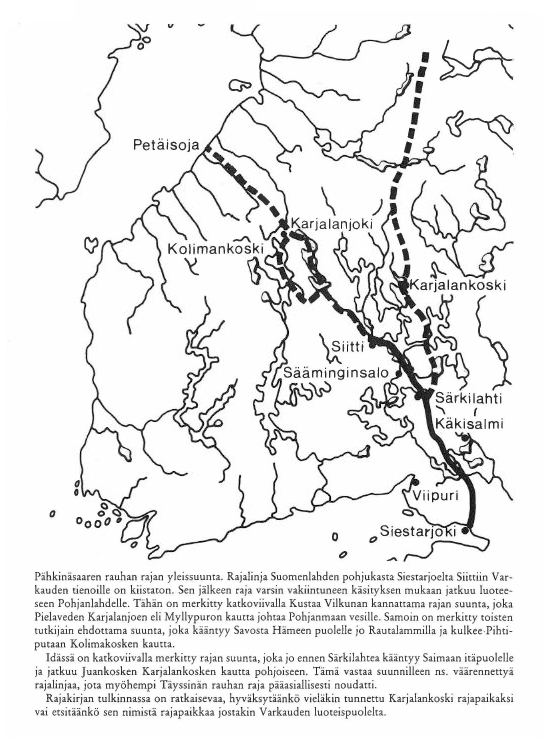
I wonder, why does the border of Oreshek and Sweden not follow the soutern part of Peace of Oreshek(Pähkinasaari) signed in 1323. I am aware that the northern area was only divided in theory, but the south really was divided accord the peace, right??
 
I have finally finished my feedback for Ingria and Karelia. Hopefully this will be helpful when these areas get reviewed!

As some have already pointed out, the borders in Ingria and Karelia are quite sloppy and inaccurate. This is an issue mainly because a lot of these borders worked as national borders during the timeframe of the game. As there are a lot of inaccuracies with the borders and the locations, I decided that the easiest way to point them all out was to draw my own version of the region with all the fixes and explanations for them.

Historical state and county borders
1720725106893.png
1720725120744.png


The dark borders are the most important ones to portray. They represent the historical state borders of Sweden and Russia and the historical borders of Swedish counties. The borders are the following:

1720724492688.png
1720724964676.png

Treaty of Nöteborg (1323)


1720724533193.png
1720724874950.png

Treaty of Teusina (1595)

1720724579383.png

Treaty of Stolbovo (1617)

1720724635788.png
1720725056011.png
1720725076021.png

Treaty of Nystad (1721) and Treaty of Åbo (1743)

1720724691520.png
1720724729515.png
1720724751671.png
1720724815022.png
1720724850676.png

The borders of the counties of Viborg, Savolax, Kexholm and Ingria. This Wikipedia article and this map are good and detailed references for province borders.

Provinces
1720725172346.png


The province borders are entirely based on historical counties. The biggest differences are with the counties of Viborg (currently Karelia) and Kexholm (currently Far Karelia). Before the Ingrian war and the Treaty of Stolbovo, the border of Sweden and Russia followed the eastern borders of the counties of Viborg and Savolax. At the time Kexholm Karelia was a subdivision of Vodskaya Pyatina, which itself was one of the five subdivisions of Novgorod Land in Russia. The territory was known as Korelsky Uyezd and it was administered from Korela (Kexholm). When Sweden received the uyezd in the Treaty of Stolbovo alongside Ingria, the borders of the uyezd were preserved and its eastern borders became state borders between Sweden and Russia. To represent this, "Far Karelia" should be given the locations on the western coast of Lake Ladoga, according to the borders of the Kexholm County as they were before and after Swedish conquest. Its name could also be changed to either Kexholm or Korela, while "Karelia" is renamed to Viborg, to match the names of the historical counties.

Another important difference is that Kajana is left outside Savolax, as historically Kajana was part of Ostrobothnia.

Countries
1720725190301.png


Sweden should be given more land in Savonia and Karelia according to the Treaty of Nöteborg. I have a more detailed explanation of what areas Sweden and Oreshek should own in 1337 in my Map of Finland thread. Oreshek is also currently missing territory. In 1333, in addition to Korela and Oreshek, which Oreshek currently own in-game, Narimantas also received Ladoga and "half of Koporye". I haven't unfortunately found any information about what "half of Koporye" means precisely. Oreshek should also be given the northern coast of Lake Ladoga, as Novgorod also ruled over so called Ladoga Karelia as part of Karelia. (More detailed explanation in my my thread.) I'm not sure how far north in Korela Novgoridian authority reached in 1337 or how it should be represented in game. The non-coastal parishes are known to have been settled in the 15th century (Kitee, Suojärvi, Ilomantsi). Many maps that represent the time period show all of Korela as part of Novgorod, but this is most likely anachronistic. The situation is complicated by Novgorod claiming all of northern Finland all the way up to the Bothnian Bay for itself according to the Nöteborg treaty, but Sweden slowly colonialized the area anyway.

It is also important to note that Narimantas's son Patrikas controlled even more territory than his father, practically all of Vodskaya Pyatina.

Locations
1720725266602.png


Many locations have been changed and renamed to be more historical. I tried to match the density of the original locations, but I don't know if the devs are planning on increasing the density. The names are all in Finnish for consistency. Most information is from Finnish, Swedish and Russian Wikipedia. The main map used as reference is this map of administrative counties in 1635, which is based on maps from 1959 Atlas of Finnish History by Eino Jutikkala. Maps from savonhistoria.fi were also used as reference, mainly this map showcasing Savonian church parish borders in 1618 and 1635 and this map of Savonian parish borders in 1870, which I used as reference for splitting apart Iisalmi and Kuopio. Ingrian locations utilize this map of 17th century Ingria from This blog post has a more detailed version of the map, but unfortunately it doesn't tell where the map is from. This book has information about Finnish and Swedish congregations in Ingria, which I used as a source for Swedish names of Ingrian parishes. Explanations for the locations alongside names in different languages are available in the spoilers below. Russian names are both in Latin and Cyrillic, in case the romanizations have errors or Paradox prefers to use another romanization standard.

FinnishSwedishRussianNotes
JääskiJäskisYaski, Yaaski or Yaskis (Яски, Яаски or Яскис)Moved to a more historical position. Replaces Heinjoki, which only became independent from the municipality of Muolaa in 1869.
KivennapaKivinebbKivennapa or Kivinebb (Ки́веннапа or Кивинебб)Replaces Valkeasaari, which is in Ingria and not former Swedish Karelia.
LappeenrantaVillmanstrandLappeenranta or Vilmanstrand (Лаппеэнранта or Вильманстранд)Could also be called Lapvesi (Lappvesi), as the city of Lappeenranta was only established in 1649. I don't think this is needed, however, as the name Lappeenranta doesn't reference any 17th century person and the name would only be inaccurate for half of the game.
MuolaaMolaMuolaa (Муолаа)Replaces Kyyrölä, which only became an independent municipality in 1890. Also has an older Swedish name Mohla.
PyhtääPyttisPyukhtya, Pyukhtyaa or Pyuttis (Пюхтя, Пю́хтяа or Пю́ттис)Replaces Kotka, which was only established in 1879.
RuokolahtiRuokolaxRuokolakhti (Руоколахти)Replaces current Jääski (Jäskis), which is too far north.
SavitaipaleSavitaipaleSavitaypale (Савитайпале)Replaces Kouvola, which only started developing in the 1870s and became an independent municipality in 1922.
UusikirkkoNykyrkaUusikirkko (Уусикиркко)
VehkalahtiVeckelaxVekhkalakhti or Vekelaks (Вехкалахти or Векелакс)Could also be called Hamina (Swe. Fredrikshamn, Rus. Khamina or Fridrikhsgam (Ха́мина or Фридрихсгам)), like its currently named. The name comes from the 18th century King Fredrik I, so it would be nonsensical for most of the game.
ViipuriVyborgVyborg (Выборг)Ideally the borders of Vyborg should follow historical parish borders like shown in the map. This is because in 1493 John, King of Denmark, allied with Grand Prince Ivan to pressure the Swedish regent Sten Sture the Elder to acknowledge John's sovereignty over Sweden under the Kalmar Union. He promised that if Ivan was able to take control of Sweden, the border of the Treaty of Nöteborg would be restored. According to Savon historia, in 1501 the Russians revealed John's promises to have been larger, promising to restore the borders predating the Nöteborg treaty. This would mean losing the parishes of Jääski, Äyräpää and Savilahti to Moscow according to their old borders. This means all of Savonia and the eastern parts of the Viborg province, with Viborg remaining part of Sweden. According to historian Kyösti Julku in his book Suomen itärajan synty, the pre-Nöteborg border very closely followed the borders of the Viborg parish in the 17th century. So if the restoration of this border happened in an alt-history scenario, the eastern border of Vyborg would form the border between Sweden and Moscow in Karelia.
VirolahtiVederlaxVirolakhti or Vederlaks (Ви́ролахти or Ведерлакс)

The Karelian names are pretty uncertain, as I was uable to find any good consistent sources for them. Karelian place names seem to be dependent on dialect and I'm not sure if the Karelian names on Wikipedia are even from the same dialect.

FinnishKarelianSwedishRussianNotes
IlomantsiIl’manči or IlomanččiIlomantsIlomantsi (Иломантси)Moved east to replace Möhkö, as that's where the center of the parish and the lake the parish is named after is situated.
JuukaJugaYuuka (Юука)
KiteeKidesKityaga (Китьяга)
KontiolahtiKontiolaxKontiolakhti (Контиолахти)
KurkijokiKronoborgKurkiyoki (Куркиёки)Replaces Lahdenpohja, as Lahdenpohja wouldn't become independent until 1924.
KäkisalmiKägöisalmiKexholmKorela (Коре́ла)
LiperiLibelitsLiperi (Липери)Replaces Joensuu, as Joensuu was only a village that was part of Kontiolahti during the game's timeframe. On the other hand, the parish of Liperi has existed since 1630.
NurmesNurmesNurmes (Нурмес)
PielisjärviPielisjärviPielisyarvi (Пиелисъярви)Replaces Lieksa, as Lieksa belonged to the parish of Pielisjärvi during the game's timeframe.
SakkulaSakkulaSakkulaSakkula (Саккула)Replaces Konevets, as Konevets is merely an island near the coast, though the monestary on the island is noteable and old.
SalmiSalmiSalmisSolomyane (Соломяне)The modern Russian name is Салми (Salmi), but, according to the Russian Wikipedia page for Salmi, it was originally Соломенский погост (Solomensky pogost). However, Solomensky is an adjective. Google translate is a bit weird sometimes, but it seems the proper name is Соломяне (Solomyane). This source seems to agree.
SortavalaSortavalaSordavalaSerdobol (Сердоболь)
SuistamoSuistamoSujstamoSuystamo (Суйстамо)The territories of Loimola (Loymola) are given to Suistamo and Suojärvi, as Loimola only became a municipality in 2006.
SuojärviSuojärviSuojärviSuoyarvi (Суоярви)
TohmajärviTohmajärviTokhmayarvi (Тохмаярви)Replaces Värtsilä, which was part of Tohmajärvi until 1920.
UukuniemiUguniemiUukuniemi (Уукуниеми)

FinnishSwedishRussianNotes
IisalmiIdensalmiIysalmi (И́йсалми)
JoroinenJoroisYoroynen or Yoroys (Йоройнен or Йоройс)
JuvaJockasYuva (Ю́ва)Replaces Ristiina, as Juva is one of the oldest parishes in Savonia, while Ristiina was established only in 1649 and it was named after a contemporary person, Kristina, the wife of Count Per Brahe the Younger.
KangasniemiKangasniemiKangasniemi (Кангасниеми)
KerimäkiKerimäkiKerimyaki (Керимяки)Replaces Savonranta, as Kerimäki is the older parish in the area (Kerimäki became a parish in 1642 while Savonranta became independent in 1868).
KuopioKuopioKuopio (Ку́опио)
LeppävirtaLeppävirtaLeppyavirta (Леппявирта)I made the western borders of Leppävirta follow Russian border demands from 1500 because plausible alt-history is cool.
MikkeliS:t MichelSankt-Mikhel (Санкт-Михель)
NilsiäNilsiäNilsiya (Нильсия)According to nilsia.fi Nilsiä was mentioned as a wilderness area in a 1561 tax list.
PieksämäkiPieksämäkiPieksyamyaki (Пиексямяки)
PielavesiPielavesiPielavesi (Пиелавеси)Existed as a chapelry since 1683 and became an independent parish in 1811.
SavonlinnaNyslottNeyshlot (Нейшлот)Replaces Olavinlinna (Olofsborg), which is the name of a castle, while Savonlinna (Nyslott) is the name of the city built around the castle. The location is situated on the eastern side of the Nöteborg border, as during construction of the castle the Russians complained that the castle was being built on their side of the border. They also demanded for the castle to be ceded to them before the First Russian-Swedish war.
SääminkiSämingeSyaaminki (Сяаминки)

FinnishEstonianSwedishGermanRussianNotes
HatsinaHottšino (Earlier) or Gattšina (Later)Gattjina (Later)Gattschina (Later)Khotchino (Earlier) or Gatchina (Later) (Хотчино or Га́тчина)Known since 1499. Originally the name started with an h sound, but around the middle of the 17th century, it was replaced with a g sound. I wasn't able to find the old version of the name in Swedish.
IivananlinnaJaanilinnIvangorodJohannstadt or IwangorodIvangorod (Ивангород)A prominent castle built by and named after Ivan III in 1492, with a town of the same name associated with it. I think it would be crucial to have in the game, though the name could cause some difficulties.
InkereInkereIngrisIzhora (Ижора)Replaces Liissilä, as in 1612, before Swedish rule, Liissilä was a village in the Izhora pogost.
JaamaJaamaJamaJamaYam or Yama (Ям or Я́ма)Moved east to the position of Moloskovits to match the borders of the historical Jama län and to make space for Ivangorod.
KaprioKoporjeKoporjeKoporjeKoporye (Копо́рье)
LoppiLoppisLoppi (Лоппи)Replaces Markkova, as Loppi is the old name of the parish. During the Great Northern War the original Lutheran church of Loppi was burned down. In 1722, a new one was built in Markkova, which is where the parish got its new name from.
NevanlinnaNyenNyenNyenNiyen (Ниен)
PähkinälinnaNöteborgNöteborgOreshek (Оре́шек)
SoikkolaSoikinaSoikino (Со́йкино)
ToksovaToksovoToksovoToksovo (То́ксово)
TuutariTuutariDuderhofDudergof (Дудергоф)Replaces Tyrö, as Tuutari as a parish is two years older and maps show Tyrö as a subdivision of Tuutari.

Additional feedback
1720725656892.png


Fulmen had a good point about the wasteland in White Karelia. Many raids were carried out over this area historically, making its representation as a wasteland problematic. This area was historically known as Forest Lapland, Novgorod Lapland or Лопские погосты (Lop' pogosts). It was formed as an administrative entity by Ivan III at the end of the 15th century and in 1650 they were transferred from the Novgorodsky Uyezd to the Olonetsky Uyezd. In game the Lop' pogosts could maybe either be part of White Karelia or form their own province. This article has good maps of the area from different years in both Russian and Finnish. Also, the border against Finland regardless if the area is a wasteland or not should definitely follow the historical border set in the Treaty of Teusina. My Finland thread has a detailed explanation of this too.

The romanization of Russian place names seems to be inconsistent. In English the j sound is usually romanized as y (й = y not j, ю = yo not jo, я = ya not ja) to be more intuitive for English speakers. Currently there are some places romanized with y such as Plyussa while some are romanized with j, such as Koporje (in Wikipedia its Koporye). There are many romanization systems for Russian, and I'm not an expert on them or which ones is the most popular, but it would be good for the romanization system to be consistent in game.
 
Last edited:
  • 11Love
  • 7Like
  • 4
  • 1
Reactions:
I have finally finished my feedback for Ingria and Karelia. Hopefully this will be helpful when these areas get reviewed!

As some have already pointed out, the borders in Ingria and Karelia are quite sloppy and inaccurate. This is an issue mainly because a lot of these borders worked as national borders during the timeframe of the game. As there are a lot of inaccuracies with the borders and the locations, I decided that the easiest way to point them all out was to draw my own version of the region with all the fixes and explanations for them.

Historical state and county borders
View attachment 1162212View attachment 1162213

The dark borders are the most important ones to portray. They represent the historical state borders of Sweden and Russia and the historical borders of Swedish counties. The borders are the following:

View attachment 1162194View attachment 1162208
Treaty of Nöteborg (1323)


View attachment 1162195View attachment 1162205
Treaty of Teusina (1595)

View attachment 1162196
Treaty of Stolbovo (1617)

View attachment 1162198View attachment 1162210View attachment 1162211
Treaty of Nystad (1721) and Treaty of Åbo (1743)

View attachment 1162199View attachment 1162200View attachment 1162201View attachment 1162202View attachment 1162204
The borders of the counties of Viborg, Savolax, Kexholm and Ingria. This Wikipedia article and this map are good and detailed references for province borders.

Provinces
View attachment 1162214

The province borders are entirely based on historical counties. The biggest differences are with the counties of Viborg (currently Karelia) and Kexholm (currently Far Karelia). Before the Ingrian war and the Treaty of Stolbovo, the border of Sweden and Russia followed the eastern borders of the counties of Viborg and Savolax. At the time Kexholm Karelia was a subdivision of Vodskaya Pyatina, which itself was one of the five subdivisions of Novgorod Land in Russia. The territory was known as Korelsky Uyezd and it was administered from Korela (Kexholm). When Sweden received the uyezd in the Treaty of Stolbovo alongside Ingria, the borders of the uyezd were preserved and its eastern borders became state borders between Sweden and Russia. To represent this, "Far Karelia" should be given the locations on the western coast of Lake Ladoga, according to the borders of the Kexholm County as they were before and after Swedish conquest. Its name could also be changed to either Kexholm or Korela, while "Karelia" is renamed to Viborg, to match the names of the historical counties.

Another important difference is that Kajana is left outside Savolax, as historically Kajana was part of Ostrobothnia.

Countries
View attachment 1162215

Sweden should be given more land in Savonia and Karelia according to the Treaty of Nöteborg. I have a more detailed explanation of what areas Sweden and Oreshek should own in 1337 in my Map of Finland thread. Oreshek is also currently missing territory. In 1333, in addition to Korela and Oreshek, which Oreshek currently own in-game, Narimantas also received Ladoga and "half of Koporye". I haven't unfortunately found any information about what "half of Koporye" means precisely. Oreshek should also be given the northern coast of Lake Ladoga, as Novgorod also ruled over so called Ladoga Karelia as part of Karelia. (More detailed explanation in my my thread.) I'm not sure how far north in Korela Novgoridian authority reached in 1337 or how it should be represented in game. The non-coastal parishes are known to have been settled in the 15th century (Kitee, Suojärvi, Ilomantsi). Many maps that represent the time period show all of Korela as part of Novgorod, but this is most likely anachronistic. The situation is complicated by Novgorod claiming all of northern Finland all the way up to the Bothnian Bay for itself according to the Nöteborg treaty, but Sweden slowly colonialized the area anyway.

It is also important to note that Narimantas's son Patrikas controlled even more territory than his father, practically all of Vodskaya Pyatina.

Locations
View attachment 1162217

Many locations have been changed and renamed to be more historical. I tried to match the density of the original locations, but I don't know if the devs are planning on increasing the density. The names are all in Finnish for consistency. Most information is from Finnish, Swedish and Russian Wikipedia. The main map used as reference is this map of administrative counties in 1635, which is based on maps from 1959 Atlas of Finnish History by Eino Jutikkala. Maps from savonhistoria.fi were also used as reference, mainly this map showcasing Savonian church parish borders in 1618 and 1635 and this map of Savonian parish borders in 1870, which I used as reference for splitting apart Iisalmi and Kuopio. Ingrian locations utilize this map of 17th century Ingria from This blog post has a more detailed version of the map, but unfortunately it doesn't tell where the map is from. This book has information about Finnish and Swedish congregations in Ingria, which I used as a source for Swedish names of Ingrian parishes. Explanations for the locations alongside names in different languages are available in the spoilers below. Russian names are both in Latin and Cyrillic, in case the romanizations have errors or Paradox prefers to use another romanization standard.

FinnishSwedishRussianNotes
JääskiJäskisYaski, Yaaski or Yaskis (Яски, Яаски or Яскис)Moved to a more historical position. Replaces Heinjoki, which only became independent from the municipality of Muolaa in 1869.
KivennapaKivinebbKivennapa or Kivinebb (Ки́веннапа or Кивинебб)Replaces Valkeasaari, which is in Ingria and not former Swedish Karelia.
LappeenrantaVillmanstrandLappeenranta or Vilmanstrand (Лаппеэнранта or Вильманстранд)Could also be called Lapvesi (Lappvesi), as the city of Lappeenranta was only established in 1649. I don't think this is needed, however, as the name Lappeenranta doesn't reference any 17th century person and the name would only be inaccurate for half of the game.
MuolaaMolaMuolaa (Муолаа)Replaces Kyyrölä, which only became an independent municipality in 1890. Also has an older Swedish name Mohla.
PyhtääPyttisPyukhtya, Pyukhtyaa or Pyuttis (Пюхтя, Пю́хтяа or Пю́ттис)Replaces Kotka, which was only established in 1879.
RuokolahtiRuokolaxRuokolakhti (Руоколахти)Replaces current Jääski (Jäskis), which is too far north.
SavitaipaleSavitaipaleSavitaypale (Савитайпале)Replaces Kouvola, which only started developing in the 1870s and became an independent municipality in 1922.
UusikirkkoNykyrkaUusikirkko (Уусикиркко)
VehkalahtiVeckelaxVekhkalakhti or Vekelaks (Вехкалахти or Векелакс)Could also be called Hamina (Swe. Fredrikshamn, Rus. Khamina or Fridrikhsgam (Ха́мина or Фридрихсгам)), like its currently named. The name comes from the 18th century King Fredrik I, so it would be nonsensical for most of the game.
ViipuriVyborgVyborg (Выборг)Ideally the borders of Vyborg should follow historical parish borders like shown in the map. This is because in 1493 John, King of Denmark, allied with Grand Prince Ivan to pressure the Swedish regent Sten Sture the Elder to acknowledge John's sovereignty over Sweden under the Kalmar Union. He promised that if Ivan was able to take control of Sweden, the border of the Treaty of Nöteborg would be restored. According to Savon historia, in 1501 the Russians revealed John's promises to have been larger, promising to restore the borders predating the Nöteborg treaty. This would mean losing the parishes of Jääski, Äyräpää and Savilahti to Moscow according to their old borders. This means all of Savonia and the eastern parts of the Viborg province, with Viborg remaining part of Sweden. According to historian Kyösti Julku in his book Suomen itärajan synty, the pre-Nöteborg border very closely followed the borders of the Viborg parish in the 17th century. So if the restoration of this border happened in an alt-history scenario, the eastern border of Vyborg would form the border between Sweden and Moscow in Karelia.
VirolahtiVederlaxVirolakhti or Vederlaks (Ви́ролахти or Ведерлакс)

The Karelian names are pretty uncertain, as I was uable to find any good consistent sources for them. Karelian place names seem to be dependent on dialect and I'm not sure if the Karelian names on Wikipedia are even from the same dialect.

FinnishKarelianSwedishRussianNotes
IlomantsiIl’manči or IlomanččiIlomantsIlomantsi (Иломантси)Moved east to replace Möhkö, as that's where the center of the parish and the lake the parish is named after is situated.
JuukaJugaYuuka (Юука)
KiteeKidesKityaga (Китьяга)
KontiolahtiKontiolaxKontiolakhti (Контиолахти)
KurkijokiKronoborgKurkiyoki (Куркиёки)Replaces Lahdenpohja, as Lahdenpohja wouldn't become independent until 1924.
KäkisalmiKägöisalmiKexholmKorela (Коре́ла)
LiperiLibelitsLiperi (Липери)Replaces Joensuu, as Joensuu was only a village that was part of Kontiolahti during the game's timeframe. On the other hand, the parish of Liperi has existed since 1630.
NurmesNurmesNurmes (Нурмес)
PielisjärviPielisjärviPielisyarvi (Пиелисъярви)Replaces Lieksa, as Lieksa belonged to the parish of Pielisjärvi during the game's timeframe.
SakkulaSakkulaSakkulaSakkula (Саккула)Replaces Konevets, as Konevets is merely an island near the coast, though the monestary on the island is noteable and old.
SalmiSalmiSalmisSolomyane (Соломяне)The modern Russian name is Салми (Salmi), but, according to the Russian Wikipedia page for Salmi, it was originally Соломенский погост (Solomensky pogost). However, Solomensky is an adjective. Google translate is a bit weird sometimes, but it seems the proper name is Соломяне (Solomyane). This source seems to agree.
SortavalaSortavalaSordavalaSerdobol (Сердоболь)
SuistamoSuistamoSujstamoSuystamo (Суйстамо)The territories of Loimola (Loymola) are given to Suistamo and Suojärvi, as Loimola only became a municipality in 2006.
SuojärviSuojärviSuojärviSuoyarvi (Суоярви)
TohmajärviTohmajärviTokhmayarvi (Тохмаярви)Replaces Värtsilä, which was part of Tohmajärvi until 1920.
UukuniemiUguniemiUukuniemi (Уукуниеми)

FinnishSwedishRussianNotes
IisalmiIdensalmiIysalmi (И́йсалми)
JoroinenJoroisYoroynen or Yoroys (Йоройнен or Йоройс)
JuvaJockasYuva (Ю́ва)Replaces Ristiina, as Juva is one of the oldest parishes in Savonia, while Ristiina was established only in 1649 and it was named after a contemporary person, Kristina, the wife of Count Per Brahe the Younger.
KangasniemiKangasniemiKangasniemi (Кангасниеми)
KerimäkiKerimäkiKerimyaki (Керимяки)Replaces Savonranta, as Kerimäki is the older parish in the area (Kerimäki became a parish in 1642 while Savonranta became independent in 1868).
KuopioKuopioKuopio (Ку́опио)
LeppävirtaLeppävirtaLeppyavirta (Леппявирта)I made the western borders of Leppävirta follow Russian border demands from 1500 because plausible alt-history is cool.
MikkeliS:t MichelSankt-Mikhel (Санкт-Михель)
NilsiäNilsiäNilsiya (Нильсия)According to nilsia.fi Nilsiä was mentioned as a wilderness area in a 1561 tax list.
PieksämäkiPieksämäkiPieksyamyaki (Пиексямяки)
PielavesiPielavesiPielavesi (Пиелавеси)Existed as a chapelry since 1683 and became an independent parish in 1811.
SavonlinnaNyslottNeyshlot (Нейшлот)Replaces Olavinlinna (Olofsborg), which is the name of a castle, while Savonlinna (Nyslott) is the name of the city built around the castle. The location is situated on the eastern side of the Nöteborg border, as during construction of the castle the Russians complained that the castle was being built on their side of the border. They also demanded for the castle to be ceded to them before the First Russian-Swedish war.
SääminkiSämingeSyaaminki (Сяаминки)

FinnishEstonianSwedishGermanRussianNotes
HatsinaHottšino (Earlier) or Gattšina (Later)Gattjina (Later)Gattschina (Later)Khotchino (Earlier) or Gatchina (Later) (Хотчино or Га́тчина)Known since 1499. Originally the name started with an h sound, but around the middle of the 17th century, it was replaced with a g sound. I wasn't able to find the old version of the name in Swedish.
IivananlinnaJaanilinnIvangorodJohannstadt or IwangorodIvangorod (Ивангород)A prominent castle built by and named after Ivan III in 1492, with a town of the same name associated with it. I think it would be crucial to have in the game, though the name could cause some difficulties.
InkereInkereIngrisIzhora (Ижора)Replaces Liissilä, as in 1612, before Swedish rule, Liissilä was a village in the Izhora pogost.
JaamaJaamaJamaJamaYam or Yama (Ям or Я́ма)Moved east to the position of Moloskovits to match the borders of the historical Jama län and to make space for Ivangorod.
KaprioKoporjeKoporjeKoporjeKoporye (Копо́рье)
LoppiLoppisLoppi (Лоппи)Replaces Markkova, as Loppi is the old name of the parish. During the Great Northern War the original Lutheran church of Loppi was burned down. In 1722, a new one was built in Markkova, which is where the parish got its new name from.
NevanlinnaNyenNyenNyenNiyen (Ниен)
PähkinälinnaNöteborgNöteborgOreshek (Оре́шек)
SoikkolaSoikinaSoikino (Со́йкино)
ToksovaToksovoToksovoToksovo (То́ксово)
TuutariTuutariDuderhofDudergof (Дудергоф)Replaces Tyrö, as Tuutari as a parish is two years older and maps show Tyrö as a subdivision of Tuutari.

Additional feedback
View attachment 1162219

Fulmen had a good point about the wasteland in White Karelia. Many raids were carried out over this area historically, making its representation as a wasteland problematic. This area was historically known as Forest Lapland, Novgorod Lapland or Лопские погосты (Lapland pogosts). It was formed as an administrative entity by Ivan III at the end of the 15th century and in 1650 they were transferred from the Novgorodsky Uyezd to the Olonetsky Uyezd. In game the Lapland pogosts could maybe either be part of White Karelia or form their own province. This article has good maps of the area from different years in both Russian and Finnish. Also, the border against Finland regardless if the area is a wasteland or not should definitely follow the historical border set in the Treaty of Teusina. My Finland thread has a detailed explanation of this too.

The romanization of Russian place names seems to be inconsistent. In English the j sound is usually romanized as y (й = y not j, ю = yo not jo, я = ya not ja) to be more intuitive for English speakers. Currently there are some places romanized with y such as Plyussa while some are romanized with j, such as Koporje (in Wikipedia its Koporye). There are many romanization systems for Russian, and I'm not an expert on them or which ones is the most popular, but it would be good for the romanization system to be consistent in game.
Incredible work, especially the Karelian borders, I hope Pavia will rewatch previous Tinto maps for there are many inaccuracies regarding location borders (understandable as they have to do the entire world).
 
  • 1
Reactions:
I have finally finished my feedback for Ingria and Karelia. Hopefully this will be helpful when these areas get reviewed!

As some have already pointed out, the borders in Ingria and Karelia are quite sloppy and inaccurate. This is an issue mainly because a lot of these borders worked as national borders during the timeframe of the game. As there are a lot of inaccuracies with the borders and the locations, I decided that the easiest way to point them all out was to draw my own version of the region with all the fixes and explanations for them.

Historical state and county borders
View attachment 1162212View attachment 1162213

The dark borders are the most important ones to portray. They represent the historical state borders of Sweden and Russia and the historical borders of Swedish counties. The borders are the following:

View attachment 1162194View attachment 1162208
Treaty of Nöteborg (1323)


View attachment 1162195View attachment 1162205
Treaty of Teusina (1595)

View attachment 1162196
Treaty of Stolbovo (1617)

View attachment 1162198View attachment 1162210View attachment 1162211
Treaty of Nystad (1721) and Treaty of Åbo (1743)

View attachment 1162199View attachment 1162200View attachment 1162201View attachment 1162202View attachment 1162204
The borders of the counties of Viborg, Savolax, Kexholm and Ingria. This Wikipedia article and this map are good and detailed references for province borders.

Provinces
View attachment 1162214

The province borders are entirely based on historical counties. The biggest differences are with the counties of Viborg (currently Karelia) and Kexholm (currently Far Karelia). Before the Ingrian war and the Treaty of Stolbovo, the border of Sweden and Russia followed the eastern borders of the counties of Viborg and Savolax. At the time Kexholm Karelia was a subdivision of Vodskaya Pyatina, which itself was one of the five subdivisions of Novgorod Land in Russia. The territory was known as Korelsky Uyezd and it was administered from Korela (Kexholm). When Sweden received the uyezd in the Treaty of Stolbovo alongside Ingria, the borders of the uyezd were preserved and its eastern borders became state borders between Sweden and Russia. To represent this, "Far Karelia" should be given the locations on the western coast of Lake Ladoga, according to the borders of the Kexholm County as they were before and after Swedish conquest. Its name could also be changed to either Kexholm or Korela, while "Karelia" is renamed to Viborg, to match the names of the historical counties.

Another important difference is that Kajana is left outside Savolax, as historically Kajana was part of Ostrobothnia.

Countries
View attachment 1162215

Sweden should be given more land in Savonia and Karelia according to the Treaty of Nöteborg. I have a more detailed explanation of what areas Sweden and Oreshek should own in 1337 in my Map of Finland thread. Oreshek is also currently missing territory. In 1333, in addition to Korela and Oreshek, which Oreshek currently own in-game, Narimantas also received Ladoga and "half of Koporye". I haven't unfortunately found any information about what "half of Koporye" means precisely. Oreshek should also be given the northern coast of Lake Ladoga, as Novgorod also ruled over so called Ladoga Karelia as part of Karelia. (More detailed explanation in my my thread.) I'm not sure how far north in Korela Novgoridian authority reached in 1337 or how it should be represented in game. The non-coastal parishes are known to have been settled in the 15th century (Kitee, Suojärvi, Ilomantsi). Many maps that represent the time period show all of Korela as part of Novgorod, but this is most likely anachronistic. The situation is complicated by Novgorod claiming all of northern Finland all the way up to the Bothnian Bay for itself according to the Nöteborg treaty, but Sweden slowly colonialized the area anyway.

It is also important to note that Narimantas's son Patrikas controlled even more territory than his father, practically all of Vodskaya Pyatina.

Locations
View attachment 1162217

Many locations have been changed and renamed to be more historical. I tried to match the density of the original locations, but I don't know if the devs are planning on increasing the density. The names are all in Finnish for consistency. Most information is from Finnish, Swedish and Russian Wikipedia. The main map used as reference is this map of administrative counties in 1635, which is based on maps from 1959 Atlas of Finnish History by Eino Jutikkala. Maps from savonhistoria.fi were also used as reference, mainly this map showcasing Savonian church parish borders in 1618 and 1635 and this map of Savonian parish borders in 1870, which I used as reference for splitting apart Iisalmi and Kuopio. Ingrian locations utilize this map of 17th century Ingria from This blog post has a more detailed version of the map, but unfortunately it doesn't tell where the map is from. This book has information about Finnish and Swedish congregations in Ingria, which I used as a source for Swedish names of Ingrian parishes. Explanations for the locations alongside names in different languages are available in the spoilers below. Russian names are both in Latin and Cyrillic, in case the romanizations have errors or Paradox prefers to use another romanization standard.

FinnishSwedishRussianNotes
JääskiJäskisYaski, Yaaski or Yaskis (Яски, Яаски or Яскис)Moved to a more historical position. Replaces Heinjoki, which only became independent from the municipality of Muolaa in 1869.
KivennapaKivinebbKivennapa or Kivinebb (Ки́веннапа or Кивинебб)Replaces Valkeasaari, which is in Ingria and not former Swedish Karelia.
LappeenrantaVillmanstrandLappeenranta or Vilmanstrand (Лаппеэнранта or Вильманстранд)Could also be called Lapvesi (Lappvesi), as the city of Lappeenranta was only established in 1649. I don't think this is needed, however, as the name Lappeenranta doesn't reference any 17th century person and the name would only be inaccurate for half of the game.
MuolaaMolaMuolaa (Муолаа)Replaces Kyyrölä, which only became an independent municipality in 1890. Also has an older Swedish name Mohla.
PyhtääPyttisPyukhtya, Pyukhtyaa or Pyuttis (Пюхтя, Пю́хтяа or Пю́ттис)Replaces Kotka, which was only established in 1879.
RuokolahtiRuokolaxRuokolakhti (Руоколахти)Replaces current Jääski (Jäskis), which is too far north.
SavitaipaleSavitaipaleSavitaypale (Савитайпале)Replaces Kouvola, which only started developing in the 1870s and became an independent municipality in 1922.
UusikirkkoNykyrkaUusikirkko (Уусикиркко)
VehkalahtiVeckelaxVekhkalakhti or Vekelaks (Вехкалахти or Векелакс)Could also be called Hamina (Swe. Fredrikshamn, Rus. Khamina or Fridrikhsgam (Ха́мина or Фридрихсгам)), like its currently named. The name comes from the 18th century King Fredrik I, so it would be nonsensical for most of the game.
ViipuriVyborgVyborg (Выборг)Ideally the borders of Vyborg should follow historical parish borders like shown in the map. This is because in 1493 John, King of Denmark, allied with Grand Prince Ivan to pressure the Swedish regent Sten Sture the Elder to acknowledge John's sovereignty over Sweden under the Kalmar Union. He promised that if Ivan was able to take control of Sweden, the border of the Treaty of Nöteborg would be restored. According to Savon historia, in 1501 the Russians revealed John's promises to have been larger, promising to restore the borders predating the Nöteborg treaty. This would mean losing the parishes of Jääski, Äyräpää and Savilahti to Moscow according to their old borders. This means all of Savonia and the eastern parts of the Viborg province, with Viborg remaining part of Sweden. According to historian Kyösti Julku in his book Suomen itärajan synty, the pre-Nöteborg border very closely followed the borders of the Viborg parish in the 17th century. So if the restoration of this border happened in an alt-history scenario, the eastern border of Vyborg would form the border between Sweden and Moscow in Karelia.
VirolahtiVederlaxVirolakhti or Vederlaks (Ви́ролахти or Ведерлакс)

The Karelian names are pretty uncertain, as I was uable to find any good consistent sources for them. Karelian place names seem to be dependent on dialect and I'm not sure if the Karelian names on Wikipedia are even from the same dialect.

FinnishKarelianSwedishRussianNotes
IlomantsiIl’manči or IlomanččiIlomantsIlomantsi (Иломантси)Moved east to replace Möhkö, as that's where the center of the parish and the lake the parish is named after is situated.
JuukaJugaYuuka (Юука)
KiteeKidesKityaga (Китьяга)
KontiolahtiKontiolaxKontiolakhti (Контиолахти)
KurkijokiKronoborgKurkiyoki (Куркиёки)Replaces Lahdenpohja, as Lahdenpohja wouldn't become independent until 1924.
KäkisalmiKägöisalmiKexholmKorela (Коре́ла)
LiperiLibelitsLiperi (Липери)Replaces Joensuu, as Joensuu was only a village that was part of Kontiolahti during the game's timeframe. On the other hand, the parish of Liperi has existed since 1630.
NurmesNurmesNurmes (Нурмес)
PielisjärviPielisjärviPielisyarvi (Пиелисъярви)Replaces Lieksa, as Lieksa belonged to the parish of Pielisjärvi during the game's timeframe.
SakkulaSakkulaSakkulaSakkula (Саккула)Replaces Konevets, as Konevets is merely an island near the coast, though the monestary on the island is noteable and old.
SalmiSalmiSalmisSolomyane (Соломяне)The modern Russian name is Салми (Salmi), but, according to the Russian Wikipedia page for Salmi, it was originally Соломенский погост (Solomensky pogost). However, Solomensky is an adjective. Google translate is a bit weird sometimes, but it seems the proper name is Соломяне (Solomyane). This source seems to agree.
SortavalaSortavalaSordavalaSerdobol (Сердоболь)
SuistamoSuistamoSujstamoSuystamo (Суйстамо)The territories of Loimola (Loymola) are given to Suistamo and Suojärvi, as Loimola only became a municipality in 2006.
SuojärviSuojärviSuojärviSuoyarvi (Суоярви)
TohmajärviTohmajärviTokhmayarvi (Тохмаярви)Replaces Värtsilä, which was part of Tohmajärvi until 1920.
UukuniemiUguniemiUukuniemi (Уукуниеми)

FinnishSwedishRussianNotes
IisalmiIdensalmiIysalmi (И́йсалми)
JoroinenJoroisYoroynen or Yoroys (Йоройнен or Йоройс)
JuvaJockasYuva (Ю́ва)Replaces Ristiina, as Juva is one of the oldest parishes in Savonia, while Ristiina was established only in 1649 and it was named after a contemporary person, Kristina, the wife of Count Per Brahe the Younger.
KangasniemiKangasniemiKangasniemi (Кангасниеми)
KerimäkiKerimäkiKerimyaki (Керимяки)Replaces Savonranta, as Kerimäki is the older parish in the area (Kerimäki became a parish in 1642 while Savonranta became independent in 1868).
KuopioKuopioKuopio (Ку́опио)
LeppävirtaLeppävirtaLeppyavirta (Леппявирта)I made the western borders of Leppävirta follow Russian border demands from 1500 because plausible alt-history is cool.
MikkeliS:t MichelSankt-Mikhel (Санкт-Михель)
NilsiäNilsiäNilsiya (Нильсия)According to nilsia.fi Nilsiä was mentioned as a wilderness area in a 1561 tax list.
PieksämäkiPieksämäkiPieksyamyaki (Пиексямяки)
PielavesiPielavesiPielavesi (Пиелавеси)Existed as a chapelry since 1683 and became an independent parish in 1811.
SavonlinnaNyslottNeyshlot (Нейшлот)Replaces Olavinlinna (Olofsborg), which is the name of a castle, while Savonlinna (Nyslott) is the name of the city built around the castle. The location is situated on the eastern side of the Nöteborg border, as during construction of the castle the Russians complained that the castle was being built on their side of the border. They also demanded for the castle to be ceded to them before the First Russian-Swedish war.
SääminkiSämingeSyaaminki (Сяаминки)

FinnishEstonianSwedishGermanRussianNotes
HatsinaHottšino (Earlier) or Gattšina (Later)Gattjina (Later)Gattschina (Later)Khotchino (Earlier) or Gatchina (Later) (Хотчино or Га́тчина)Known since 1499. Originally the name started with an h sound, but around the middle of the 17th century, it was replaced with a g sound. I wasn't able to find the old version of the name in Swedish.
IivananlinnaJaanilinnIvangorodJohannstadt or IwangorodIvangorod (Ивангород)A prominent castle built by and named after Ivan III in 1492, with a town of the same name associated with it. I think it would be crucial to have in the game, though the name could cause some difficulties.
InkereInkereIngrisIzhora (Ижора)Replaces Liissilä, as in 1612, before Swedish rule, Liissilä was a village in the Izhora pogost.
JaamaJaamaJamaJamaYam or Yama (Ям or Я́ма)Moved east to the position of Moloskovits to match the borders of the historical Jama län and to make space for Ivangorod.
KaprioKoporjeKoporjeKoporjeKoporye (Копо́рье)
LoppiLoppisLoppi (Лоппи)Replaces Markkova, as Loppi is the old name of the parish. During the Great Northern War the original Lutheran church of Loppi was burned down. In 1722, a new one was built in Markkova, which is where the parish got its new name from.
NevanlinnaNyenNyenNyenNiyen (Ниен)
PähkinälinnaNöteborgNöteborgOreshek (Оре́шек)
SoikkolaSoikinaSoikino (Со́йкино)
ToksovaToksovoToksovoToksovo (То́ксово)
TuutariTuutariDuderhofDudergof (Дудергоф)Replaces Tyrö, as Tuutari as a parish is two years older and maps show Tyrö as a subdivision of Tuutari.

Additional feedback
View attachment 1162219

Fulmen had a good point about the wasteland in White Karelia. Many raids were carried out over this area historically, making its representation as a wasteland problematic. This area was historically known as Forest Lapland, Novgorod Lapland or Лопские погосты (Lapland pogosts). It was formed as an administrative entity by Ivan III at the end of the 15th century and in 1650 they were transferred from the Novgorodsky Uyezd to the Olonetsky Uyezd. In game the Lapland pogosts could maybe either be part of White Karelia or form their own province. This article has good maps of the area from different years in both Russian and Finnish. Also, the border against Finland regardless if the area is a wasteland or not should definitely follow the historical border set in the Treaty of Teusina. My Finland thread has a detailed explanation of this too.

The romanization of Russian place names seems to be inconsistent. In English the j sound is usually romanized as y (й = y not j, ю = yo not jo, я = ya not ja) to be more intuitive for English speakers. Currently there are some places romanized with y such as Plyussa while some are romanized with j, such as Koporje (in Wikipedia its Koporye). There are many romanization systems for Russian, and I'm not an expert on them or which ones is the most popular, but it would be good for the romanization system to be consistent in game.
Narimantas was not the actual owner of the territories. He was only given income from the lands in exchange for a promise of military assistance.
He was a prince in Nogorod only in 1333-1335 and left Novgorod forever
He did not provide any assistance in the war with Moscow, and in 1348 the Prince of Moscow, Semyon the Proud, officially became the Prince of Novgorod.
Lithuanian Orуshek as a country is a fantasy.
Narimantas was deprived of income from his estates as soon as they realized that there would be no military assistance from him.
There were no Lithuanian garrisons there. There were no administrative changes.
These were the same Novgorod possessions.
This is a common Novgorod practice; there was no talk of any transfer of land into ownership.
Not in the 14th century. nor in the 15th century.

Moreover, you cannot draw under Orуshek - the city of Ladoga is the ancestral Novgorod land, the first capital of the Rurikovichs, one of the most important fortresses and a 100% Russian-speaking city that controlled the exit from the Volkhov River to Lake Ladoga.

It is better to make the Karells as a separate faction of the rebels and Ingrians.
 
Last edited:
  • 1Like
Reactions:
Novgorod was not located on the sea, because Russian trade was mainly river-based. Neva trough Novgorod to Volga to Caspian sea, or Neva through Novgorod to Dnypro, there was also a way from Dvina to Dnypro, which is why Riga became so promiment under Russian control. First Russian ship was actually built for Caspian sea in Nizhny Novgorod, which is located on the Volga. Second ship was built in a village Dedinovo, because it was place of first European-style shipyard, and this village is located on the river Oka.

I hope Paradox would reflect this somehow, because it is really a core of everything going on with Russia and Eastern European plane in particular.
I hope so as well, but the market maps make it seem like trade just spreads out circularly in all directions from market capitals, and river play zero role at all. I really hope the devs have some interest in simulating how rivers were vital to trade, transport, and expansion in Russia and many other places across the world.
 
  • 4
  • 1Like
  • 1
Reactions:
Narimantas was not the actual owner of the territories. He was only given income from the lands in exchange for a promise of military assistance.
He was a prince in Nogorod only in 1333-1335 and left Novgorod forever
He did not provide any assistance in the war with Moscow, and in 1348 the Prince of Moscow, Semyon the Proud, officially became the Prince of Novgorod.
Lithuanian Orуshek as a country is a fantasy.
Narimantas was deprived of income from his estates as soon as they realized that there would be no military assistance from him.
There were no Lithuanian garrisons there. There were no administrative changes.
These were the same Novgorod possessions.
This is a common Novgorod practice; there was no talk of any transfer of land into ownership.
Not in the 14th century. nor in the 15th century.

Moreover, you cannot draw under Orуshek - the city of Ladoga is the ancestral Novgorod land, the first capital of the Rurikovichs, one of the most important fortresses and a 100% Russian-speaking city that controlled the exit from the Volkhov River to Lake Ladoga.

It is better to make the Karells as a separate faction of the rebels and Ingrians.
Ah, thanks for the correction. I saw another post about this earlier, but wasn't sure how correct it was, so I decided to go with how Paradox represents it currently.

What do you mean by the Karells being a separate faciton of the rebels? Are you referring to the Karelian rebellion that took place in 1337? Interestingly sources that mention the rebellion say that the rebellion was due to harsh taxation by Narimantas, but that seems to conflict with him leaving Novgorod in 1335.

Incredible work, especially the Karelian borders, I hope Pavia will rewatch previous Tinto maps for there are many inaccuracies regarding location borders (understandable as they have to do the entire world).
Thanks! I doubt they have started reworking Russia yet, all the Tinto Maps feedback threads have been posted in the same order as the Tinto Maps themselves, so they're probably focusing on Poland and the Baltics currently. I agree that the task of mapping the entire world in a specific year hundred of years ago in incredible detail is an insane task, but that's why they started doing Tinto Maps.
 
  • 2
Reactions:
Ah, thanks for the correction. I saw another post about this earlier, but wasn't sure how correct it was, so I decided to go with how Paradox represents it currently.

What do you mean by the Karells being a separate faciton of the rebels? Are you referring to the Karelian rebellion that took place in 1337? Interestingly sources that mention the rebellion say that the rebellion was due to harsh taxation by Narimantas, but that seems to conflict with him leaving Novgorod in 1335.


Thanks! I doubt they have started reworking Russia yet, all the Tinto Maps feedback threads have been posted in the same order as the Tinto Maps themselves, so they're probably focusing on Poland and the Baltics currently. I agree that the task of mapping the entire world in a specific year hundred of years ago in incredible detail is an insane task, but that's why they started doing Tinto Maps.
In Oreshek, tax collectors of Narimantas's son were mentioned in 1346. in other locations mentioned earlier - no.
Perhaps they left him part of the income, in the hope that he would return to help. Or his son worked there purely as a mercenary, who was paid from taxes collected locally.

Novgorod later invited a representative of the Narimantas clan as a prince several times.
The reason is that each prince brought his own small army - several hundred (300) horsemen at arms.
And they were allocated income from certain territories to support the troops.

But it is impossible to talk about some kind of principality of Narimantas as a separate entity, a country in the format of a game with its own tag.

I mean that if the goal is to display locations where a certain faction of the rebels should appear (by culture - Karelians, or Ingrians), then it will be more correct to display the realism of their region than to draw a principality that did not exist.
 
  • 2Like
  • 1
Reactions:
Please consider renaming Yazhelbitsy to Valdai (or Valday) cause it was more populated town at this time and perhaps it's older. Btw this area is famous for its hills ("Valdayskaya vosvyshennost") which can be seen on Valdai's CoA.
Source: i live here
 
Last edited:
btw, what romanization system are you guys using for East Slavic languages? ICAO it looks like? I'm personally a tad partial to the Scholarly form of romanization, which minimizes digraphs and writes marks palatalization with an accent.
 
As usual, i'm late to the party due to uni commitments (it takes quite the time to do these posts!), but quite the few things in these maps caught my attention, and i upfrontly apologize if anything i complain about here has already been commented and/or replied to, i just can't get around the time to reading everything (as i have done before posting such comments in previous Tinto Maps threads), i'll be mostly sticking around to what i'm familiar with – That means, the Finno-Ugrians and Tatars, or, uh, the particularly un-Russian part of the Russia map . I assume there will be in the future a Golden Horde (Pontic Steppe?) Tinto Maps, so kinda sorry as well if anything i criticize here would be better served being criticized in this future potential thread. Anyway, the cautioning being done, let me address the issues i have.

The thing that came to my attention almost immediately was the geographic extension of Mari culture (it is too small for the time), and the fact that it is so starkly divided into two pockets (not the case historically). I don't know how exactly the devs reached, even if it was to roughly replicate the modern Mari cultural borders (which would be a big mistake, since well, the game starts in 1337 doesn't it), it fails to do so – and it would be fated to fail anyway, since the context isn't there, as seen by the extension of nearby "Kazani" culture. It is hard to super-impose the different maps by eye alone, but if i'm right, Mari culture is dominant in Kutarka, Sernur, Urzhum, and Morki (western pocket) plus the locations between Zainsk and Archit (eastern pocket), i can't quite figure out the border between Erzya (what going on over there, Erzya shouldn't be there) and Mari? It seems to be around Bizhbulyak, roughly.

Anyway, what truly matters here is that it's quite wrong: The "original" settlement area of the Mari was along the Volga, and as such, their subject (!) status to the Golden Horde is inherited from similar tributary (!) arrangements with Volga Bulgaria (R.I.P.) and, if Jordanes of Getica fame, is to be interpreted that way, the Goths (there are some controversial readings of Imniscaris and Merens as equivalent to "Cheremisa" and "Mari", but that's just a fun fact). The point is: Their original position along the Volga is quite important to their place in history, and their slow displacement from that area of settlement something that shaped today's – and indeed, the historical – geographic distribution of the group. From Svechnikov's Joining of the Mari region to the Russian State (publicly available, but in Russian...), page 56-57:
The Russians [lit. "Slavic-Russians"] gradually either assimilated or supplanted the Mari, forcing them to migrate east. This movement has been traced by archaeologists since about the 8th century AD; the Mari, in turn, came into ethnic contact with the Permian-speaking population of the land between the Volga and Vyatka rivers [lit. "Volga-Vyatka interfluve"] (the Mari called them Odo, that is, they were Udmurts). The newcomer ethnic group prevailed in the ethnic competition. In the 9th–11th centuries the Mari basically completed the development of the lands between the Vetluzh and Vyatka rivers [lit. "Vetluzh-Vyatka interfluve"], displacing and partially assimilating the previous population. Numerous legends of the Mari and the Udmurts testify that there were armed conflicts, and mutual antipathy continued to exist for quite a long time between representatives of these Finno-Ugric peoples.

As a result of the military campaign of 1218–1220, the conclusion of the Russian-Bulgar peace treaty of 1220 and the founding of Nizhny Novgorod at the mouth of the Oka River in 1221 – the easternmost outpost of Northeastern Rus' – the influence of Volga Bulgaria in the Middle Volga region weakened. This created favorable conditions for the lords of Vladimir-Suzdal to conquer the Mordva ["Mordvi"]. Most likely, during the Russian-Mordovian War of 1226–1232. The “Cheremis” [i.e., Mari] of the lands between the Oka and Sura rivers [lit. "Oka-Sur interfluve", these are often categorized under the "Principality of Purgaz" alias] were also involved.

All of this is to say that the extension of Mari culture is, well, wrong. It should go as north as russian-ruled Vyatka Land – According to the Tale of the Country of Vyatka, ushkuynik river pirates took the Mari town of "Koksharov" (Kotelnich, but "Kakshär" in Mari). So locations like Koksharov, Orlov, Slobodskoy, Bolshaya Yakshaga(?), Suna and Nikolsky (the latter two are depicted as Komi in the map, when, as the toponym for Suna indicates, it was originally most likely Mari settlement land – Take a look at this, also in russian), Vyatka itself should be Muscovite with a significant Mari (peasant) minority – Most Vyatka Land locations should have Muscovite or Novgorodian burgher pops, but i don't like the polity's current borders, if i'm to be honest.

The same extension problems go south, east, and westwards: As shown before, the Mari have expanded at the expense of the Udmurts by 1337, and Kilmez (which the naming settlement itself was founded by Mari people), Nema and Uni locations should be predominantly Mari, meanwhile, Ust-Cheptsa should be Udmurt instead of Komi. Vyatskiye Polyany should have Mari (and Tatar!) pops, but still be predominantly Udmurt, while i don't know why Yelabuga location (recognized for being the site of a Bulgar border castle) is Udmurt, it has more deal being Kazani than most Kazani locations (Udmurt minority wouldn't hurt, but Udmurt dominant?), at last in that front: Olı Bäräzä and Calli should be Mari majority, Bogatye Saby is the only of the area with recorded Tatar settlement this early (and if Oli Baraza is anything to go by, should be named accordingly as its Tatar name: Baylar Sabasy) and should have Mari pops as well, although you've stated that this area has not had its minorities properly located, so i guess OK.

At last, westwards. This is the main issue, you see. Mari culture should go as far as (nearing) Nizhny Novgorod, but not even Yoshkar Ola (the capital of their own modern-day republic!) made the cut for Mari culture. Yoshkar Ola, Yaransk (founded in the 16th century specifically as a fortress to supress Mari rebellion), Kiknur (first mentioned in the Lvov Chronicle as a "Cheremis volost"), Tonshayevo (Mari "Pizhempal"), Uren (toponym apparently comes from Mari for "squirrel"), Sharanga (it is a Mari culture location in the modern day, being a center for the Northwestern Mari), Kozmodemyansk (originally a Mari wooden fort), Vasilsursk (originally a Mari wooden fort), Voskresenskoye (only settled by russians in the 16th century), Krasnye Baki (17th century), Varnavino (settled in the 15th century), Vetluga (the Mari settlement of Yur, capital of a principality), Manturovo (originally a Mari settlement, russian-settled in the 17th century) and Pyschug (a particularly Mari toponym, russian-settled in the 17th century) should all be Mari-majority locations at the game's start date.

Finishing the Mari tangent with border advice, there's many issues with how the borders are between the Horde and its neighbors.
- Nikolsky and Bolshaya Yakshaga should go from Vyatka to the Horde.
- Nema, Kilmez, Uni, Vyatskiye Polyany and Yelabuga shouldn't be Perm's, but the Horde's.
- Kozmodemyansk, Vasilsursk, Voskresenskoye, Krasnye Baki, Varnavino, Vetluga, Manturovo, Pyschug, Cheboksary, Alikovo, Sechenovo, Ardatov, Kasimov and Kadom (these last three were historically only returned to "Russia" in 1392) should go from their respective Russian princedoms to the Horde.
- Pronsk location should be an OPM – the Principality of Pronsk.
- It'd be great if instead of direct Horde control (which, as i've stated in the beginning, wasn't a thing for many of the Mari), we could have actual Mari tags: the Malmyzh Principality and the "Vetluzhskoe Kuguzstvo" (take the link as a reference, not a source) come to my mind when talking about this. The Udmurts should have a similar thing vis-a-vis Great Perm, that shouldn't be such a monolith in the first place: Great Perm was directly rivalled in the Komi sphere by "Little Perm" (at start-date should be a vassal of Novgorod) and the Udmurt tribes didn't pay sustained submission to Perm – We know some of them by name (e.g; There could be a Kalmez – Yes they're named after the Kilmez location, and river, and also yes they were expelled from there – tag bordering the Mari lands).

Moving on, i feel like there's an absence of the relevant Merya (referred to still have been living in Lake Galich by the latter half of the 14th century, and been pagans!) and, especially (because of their undoubtedly late survival), Meshchera populations. Adding two whole "relic" cultures may sound unnecessary, but, especially in the case of Merya, these can be abstracted away by, if the devs are unwilling to add two new cultures, "give" these pops to the next-best culture (after all, we still can't be sure if these tribes were culturally "independent"), Merya pops could very well be Mari pops ‐ It is actually a very common theory, to the point where i've seen some papers saying that there were Mari in Galich Mersky because of the Andrew of Galich reference – and Meschera pops could be Erzya or Moksha pops (given that the Erzya be placed at the right place, of course!), it's good to notice that, at least before the 16th century, it was very common for Russians to treat all "Mordvins" as the same cultural community (despite the Moksha/Erzya dividing dating roughly to the Mongol invasion), speaking of that – We have an Erzya culture in the wrong place, and no Moksha one? What's up with that? Anyway:
• "Merya" (could be represented Mari) minorities in Grad Mersky (where they should be pagan), Rostov (where they should be Orthodox), Pereyaslavl (Orthodox), Nerekhta (Orthodox), Kostroma (Orthodox), Kashin (and the location to the north of it, Orthodox) Mologa and Uglich (these latter two representing the ancestrals of modern russian populations like the Sitskari, look it up! They should be Pagan). Plus the whole area east of Moscow should have (all christianized) minorities, although they shouldn't necessary have map-visible relevancy in numbers, i can only assure that it would be the case in Noginsk – Merya toponymy survived there for a notable amount of time, there's even a "Mery" (меры) village, which was originally (before the 17th century) called "Merya" (меря) –, Osovets and Kurosvkoye – both locations where the Neryanska valley is located, it was still called the "Meryanska" river during the reign of Ivan I Kalita. Beyond that, they should be actual majorities in the region of Merovia, that would be comprised of roughly Semyonov, Gorodets and Kovernino locations. These majorities are what i honestly feel like would be the greatest reasons for a separate "Merya" culture (because otherwise there would not be an important distinction between proper Mari and Merya populations), the Gorodets ones should be Orthodox, but the Semyonov and Kovernino ones should be pagan. Curiously, the noticeable geographical gap between my proposed Osovets/Kurovskoye minorities and the majorities in Merovia isn't at all due to lack of info, but a noted demographic trend detected by genetic evidence (the region around Rostov-Suzdal-Vladimir was the nucleus of an event where East Slavic settlers pretty much supplanted the previous Finnic population, with a considerable amount of such population going east).
• "Meshchera" (could be represented by Erzya or Moksha) pops in most (not all, a lot of it is traditional Moksha land) of Meshchera region, it would go roughly Kasimov, Melenki, Shilovo, Tuma, ???? (can't read) Polyana, Sasovo and Putyatino locations should be their majorities, while Yegoryevsk, Sudogda and Sarai locations should be their minorities.

The whole earlier point about no Moksha and Meshchera cultures makes me remember of another thing: Mishary culture in 1337? I have my own problems with the extent of Kazani for the start-date (It's early enough for most of the region previously associated with Volga Bulgaria to still be Oghur-speaking/Chuvash), but i think the culture existing in itself is understandable, even though i think it should be contained to the main centres in the region. But Mishary shouldn't exist at all in 1337, their proper ethnogenesis came after the Kazani (heavily associated with the Kazan Khanate) one historically, and coincided, as their own name suggests, with the assimilation of the last remaining "Meshcherans", "Mishary Tatars" stand for "Meshcheran Tatars", the thing is, in 1337, Meshcheran people are still quite recognizably existant, while Tatar settlement in the region of the Mishar geographic nucleus is, quite contrastly, not. IMO, there should be a unified "Volga Tatar" (not necessarily with that name, it can be just Kazani, i guess, although the direct reference to Kazan may not make that much sense in 1337) culture, of which, if the necessary events happen, can create a separate Mishar culture. Besides not making much sense, Mishary is currently placeholding a lot of land that should be of dominant Meshchera (as i have explained already) and/or Moksha culture – They have historically populated everything from the northern parts of modern Tambov Oblast to the western half of Penza Oblast, besides their current populations in western Mordovia and eastern Ryazan Oblast (and the Mongols recognized it), by the way, the current Golden Horde capital, the homonym city, would be largely a majority-Moksha location, and even though the map has no location named after illustrious Noroshasht, the location where the city would be located is named Mokshan, which i find ironic.

I don't quite understand the eastern pocket of Vepsians, for all their land should be Komi by the game's start date. I'd also propose the division of Komi culture between Permyak and Zyryan, it dates to the medieval period, and is materially visible – That is, the Permyaks are archaeologically represented by the Rodanovo Culture and the Zyryans are archaeologically represented by the Vym Culture, it is also noteworthy that "Great Perm" is mainly representative of the Permyaks, while "Little/Old Perm" is considered to be mostly a Zyryan "state" (so both cultures would have a "culture tag" from the start).

At the same time, the Novgorodians are currently over-represented in the culture map, locations like Yarensk, Koryazhma, Uftyuga, Vyya, Zanyuchka and Malaya Ilesha should be Komi majorities, even though they're in fact under the control of Novgorod (or, as it would be more fitting for some of them, a Little Perm vassal). Zanyuchka and Uftyuga should have a considerable Novgorodian minority, representing the beginning of proper colonization (settlement) of their respective river basins, but the remaining locations (and those Nenets-majority locations that are currently adjacent!) shouldn't have map-shown Novgorodian minorities (unless if for the reason of low-population that allows a hundred or so traders and officials to be a significant population). At last, besides the weird Tengriism thing going on over there (which i don't understand the reason behind), IMO the Pomors are surprisingly well-modelled in a geographic view, actual congratulations, the current extent of the culture follows neatly the state of northern Pomor expansion.

And that's it for today. My best of wishes for the devs, and for those in the forum who just read this mess of a textwall (that took three days to write), i hope that i could be of help, even though i came in quite late – and sorry for literally anything that i've said here that was already said elsewhere, i usually read the entire thread before doing these kinds of posts, but i didn't get the time with this one (and things snowballed quite quickly).
 
  • 5
  • 3Like
  • 1Love
Reactions: