• We have updated our Community Code of Conduct. Please read through the new rules for the forum that are an integral part of Paradox Interactive’s User Agreement.

Tinto Maps #9 - 5th of July 2024 - Carpathia and the Balkans

Greetings, and welcome to another Tinto Maps! This week we will be taking a look at Carpathia and the Balkans! It will most likely be an interesting region to take a look at, with a lot of passion involved… So I’ll just make an initial friendly reminder to keep a civil discussion, as in the latest Tinto Maps, as that’s the easiest way for us to read and gather your feedback, and improve the region in a future iteration. And now, let’s start with the maps!

Countries:
Countries.png

Carpathia and the Balkans start in a very interesting situation. The Kingdom of Hungary probably stands as the most powerful country in 1337, but that only happened after the recovery of the royal power enforced by Charles I Robert of the House of Anjou, who reined in the powerful Hungarian nobility. To the south, the power that is on the rise is the Kingdom of Serbia, ruled by Stefan Uroš IV Dušan, who has set his eyes on his neighbors to expand his power. The Byzantine Empire, meanwhile, is in a difficult position, as internal struggles ended in Andronikos III being crowned sole emperor, at the cost of dividing the realm; both Serbia and Bulgaria have in the past pressed over the bordering lands, while the Ottomans have very recently conquered Nicomedia. The control over the Southern Balkans is also very fractioned, with a branch of the Anjou ruling over Albania, the Despotate of Epirus under the nominal rule of Byzantium as a vassal, Athens, Neopatria and Salona as vassals of the Aragonese Kings of Sicily, Anjou protectorates over Achaia and Naxos, and only nominal Byzantine control over Southern Morea. It’s also noticeable the presence of the Republics of Venice and Genoa, which control several outposts over the Adriatic and Aegean Seas. A final note: in previous maps, Moldavia was shown in the map, but we’ve removed it from it, and it will most likely spawn through a chain of events in the 1340s.

Dynasties:
Dynasties.png

The House of Anjou rules over Naples, Hungary, Albania, Achaia, and Cephalonia; they’re truly invested in their push for supremacy over the region. Apart from that, each country is ruled by different dynasties, except for Athens and Neopatria, ruled by the House of Aragón-Barcelona.

Locations:
Locations 1.png

Locations 2.png

Locations 3.png

Locations 4.png
This week we’re posting the general map of the region, along with some more detailed maps, that can be seen if you click on the spoiler button. A starting comment is that the location density of Hungary is noticeably not very high; the reason is that it was one of the first European maps that we made, and we based it upon the historical counties. Therefore, I’m already saying in advance that this will be an area that we want to give more density when we do the review of the region; any help regarding that is welcome. Apart from that, you may notice on the more detailed maps that Crete appears in one, while not being present in the previous one; because of the zooming, the island will appear next week along with Cyprus, but I wanted to make an early sneak peek of the locations, given that is possible with this closer zoom level. Apart from that, I’m also saying in advance that we will make an important review of the Aegean Islands, so do not take them as a reference for anything, please.

Provinces:
Provinces.png

Provinces! Nothing outstanding to be commented on here; as usual, we’re open to any feedback regarding them.

Terrain:
Climate.png

Topography.png

Vegetation.png

Terrain! The climate of the region is mostly divided between Continental and Mediterranean, with some warmer and some colder regions. Regarding the topography, the Carpathian mountains are famously important and strategic, while the Balkans are a quite hilly and mountainous region, which is also greatly covered by woods and forests.

Cultures:
Cultures.png

Here comes the fun part of the DD: The cultural division of the Balkans! A few comments:
  1. Hungary is full of different minorities. Transylvania, especially, is an interesting place: there we have a mix of ‘Hungarians’, ‘Transylvanians’ (which are the Romanian-speaking inhabitants of the region), ‘Transylvanian Germans’, and ‘Szekely’ people.
  2. We have divided the Southern Slavic-speaking region into their dialectal families of Slovene, Croatian, Bosnian, and Serbian.
  3. The Southern Balkans are mostly divided among Bulgarian, Albanian, and Greek cultures.
  4. We’re also portraying plenty of other cultures, such as Dalmatians, Aromanians, Sclavenes, Arvanites, Cumans, Jasz, or Ashkenazi and Romanyoti Jews.

Religions:
Religion.png

This one is also interesting. Apart from the divide between Western Catholicism and Eastern Orthodoxy, we have the Krstjani in Bosnia, Bogomils (the pink stripes both in Bosnia and Macedonia), and Paulicians in Thrace. The Jewish populations do not pass the threshold percentage to appear on the map, but there are plenty of communities across the region.

Raw Materials:
Raw Materials.png

The materials of the region. Something very noticeable is the richness of minerals, with plenty of Iron, Copper, Tin, Lead, Gold, and Silver. Specifically, Slovakia is very rich, and you definitely want more settlers to migrate to the region, and exploit its resources. The region is also very rich in agricultural resources, as you can see.

Markets:
Markets.png

The region is mostly divided among four markets: Venice, Pest, Ragusa and Constantinople.

Country and Location population:
Population 1.png

Population 2.png

Population 3.png

Population 4.png
Country and location population (which I’ve also sub-divided, and is under the Spoiler button).

And that’s all of today! I hope that you find the region interesting; we certainly think that it is. Next week we will go further south, and we will take a look at the Syrian Levant and Egypt. Cheers!
 
  • 193Like
  • 69Love
  • 7
  • 4
  • 3
  • 1Haha
Reactions:
This conversation has stopped being productive several pages ago
 
  • 11Like
  • 3
Reactions:
Is in PC Dalmatian an italian or slavic/croatian culture? Will Ragusa be italian or croatian? It should be italian/venetian by culture if i remember correctly
Dalmatian is in latin culture family. Like remnants of ancient Romans and Romanised people, so it is related to Italian. Ragusa seems to be mainly Dalmatian with some stripes over it which I guess is Venetian. Over time the coastal cities and even Ragusa became more and more slavic, it was gradual.
 
  • 3
Reactions:

One thing that comes to mind is that Kastoria in Upper Macedonia, a town reportedly named after the Greek word for beaver, was a center of fur production. That's probably more noteworthy than the beans they're growing in the current setup.


The Devol location (the plateau in the east of Albania, just off of Lake Ohrid) corresponds to the Korçë Plain, which I read was a bog before being drained under Enver Hoxha.
 
  • 4Like
Reactions:
This is a modern Dialect map mostly for internal Yugoslav usage. Serbia as the Yugoslav head power always had the subtle Idea to divide and somewhat dominate if not conquer. The truth is, that the Bulgarian language in the middle ages first Old Church Slavonik (Old Bulgarian), later (as in 1337) middle Bulgarian had a completely different grammar and fonation. Those languages are almost not intelligible to a modern Bulgarian. And today we have absolutely no Idiea of the Dialects which might have existed. If we look at written Language Bulgarian sources from the 14th century, then we notice, that the Turnovo Patriarch and a local Monk from Syar (today Serres) called Isay, write in the same language with the same Grammar and same Lexic. Isay wrote about the Battle of Chernomen. The Bulgarian Language (together with Macedonian Dialect) changed massively during the Ottoman rule and diverged into many Dialects. This divergence happened also with greek, but the Greeks took care of changing the "Demotika" Language back to a more classical Greek fashion.

So this divergence of dialects is unlikely in 1337 and using this map for medieval history is massively inappropriate.

By the way if you are interested how middle Bulgarian sounds, there is a recital of Monk Isay`s account of the battle of Chernomen in most of the song Chernomen of the Band Isihia. It sounds very cool but also very different from modern Bulgarian dialects (incuding Macedonian).
As far as I can say, my suggestion, Is not in controversy with your comment.
I am really not a expert in history of Bulgarian language, but more in South-West slavic languages. Thats why I don't suggest to devide Bulgarian or unite it with some other language. There are more conpetent people than me in this question, for sure.

My comment was more about Croatian culture and neighbours.
Also it makes sense to mention Torlakian, instead of just making bald Serbo-Bulgarian border, as we have in the map. Torlakian is big enough to make it as a separate culture, but it is not up to me to decide.

BTW, you ca see the difference in maps: The first one is an approximation before Ottoman invasion and mass migration that followed it. Thats why, this map is more relevant, than the other two
 
  • 3Like
  • 1
Reactions:
THIS PROPOSAL IS OUTDATED - SEE PAGE 69 FOR UPDATED PROPOSAL.

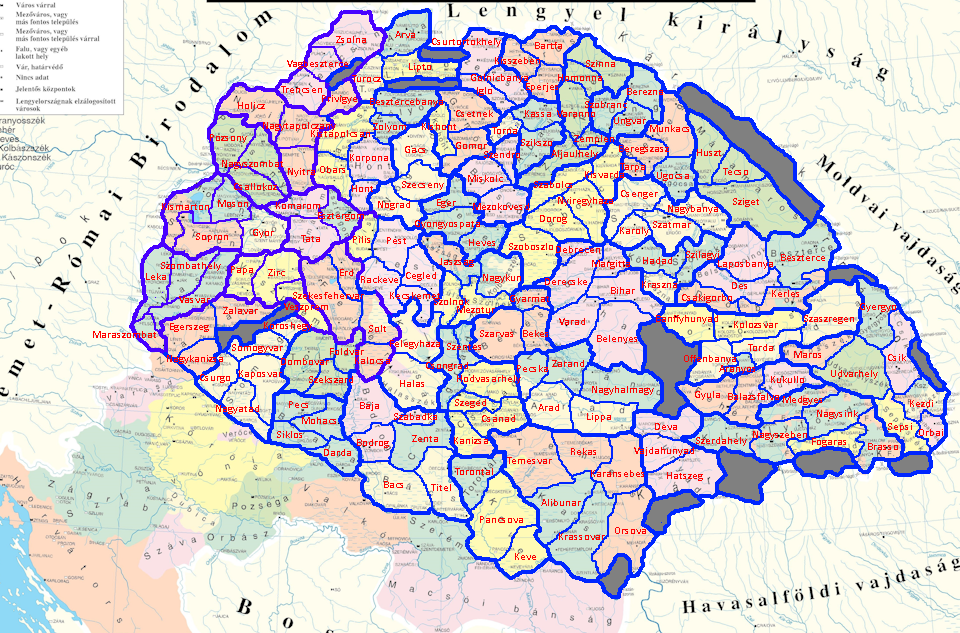
Given Hungary's rather large locations, I have a suggestion for a much more broken down Hungary (sans Croatia). This one has almost 2x the locations, where provinces are based on individual (if large) or combined (if small) Counties. Included are location and elevation maps, with thicker lines signifying province boundaries.

1720560462997.png


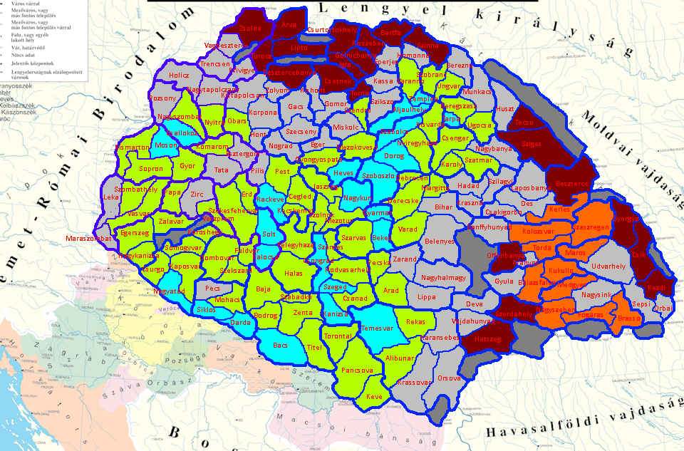
1720560550053.png


NOTE 1: I based my division on the pre-Ottoman-invasion counties of Hungary, avoiding bordergore, following historical county borders whenever possible, geographical and ethnic borders otherwise, and borders from outside PC's timeframe if the first three principles weren't conclusive. That is, I didn't prioritize following modern borders, but there are very few places where I outright ignored them.
NOTE 2: I didn't consider trade goods, climate, or vegetation, so it may make sense to change up the exact layout for this or other reasons.
NOTE 3: The location names are in Hungarian for standardization, but they don't contain diacritics because that's too much effort.
NOTE 4: I followed the cultures presented by Tinto; however, I have a proposition for semi-dynamic culture in the works that would alter a couple of the cultures involved.
EDIT: NOTE 5: The exact spread of Hungarian marshes and floodplains is difficult to get data on, so this is my best estimation based on about two sources. It may make sense to turn a few of them into flatlands.
EDIT: NOTE 6: This is something like a 75% increase in number of locations, which makes me think that I went just a little overboard, so I think it's pretty reasonable to combine a few locations here and there.
EDIT: NOTE 7: The large Carpathian wasteland in the north could probably be cut in half, based on mountain pass feedback later in the thread.

Going through the map by areas and provinces, we have:

TRANSDANUBIA
Gyor-Moson-Sopron: combines three small adjacent counties (historically combined anyway post-WW1). Also includes ethnically Austrian lands in Kismarton (roughly following the modern border for convenience).
Vas: includes two flat Hungarian locations in Vas County, a largely Austrian and hilly Leka, and a largely Slovene and hilly Muraszombat (again, roughly following modern borders for convenience). NOTE: Muraszombat crosses over into the part of IRL Zala County which is also hilly Slovene; otherwise it would also be too small.
Zala: includes three locations in Zala County. Doesn't include the bit in Northern Croatia or the bit that went to Muraszombat.
Veszprem, Somogy, Tolna, Baranya: all four provinces follow historical counties of the same name.

DUNA
Komarom-Esztergom: combines two small adjacent counties (historically combined anyway post-WW1). While Komarom is split into two by the Danube, I chose to keep Esztergom as a single entity because otherwise it would be too small.
Pest: includes the core of Hungarian lands in Pest and Pilis counties (the two would be united early on). Does not include Solt (united halfway through the game) or Kiskun (united towards the end). I chose not to split Pilis into Buda+Obuda+Visegrad as all three of those would be painfully tiny. Rackeve should probably have some Cuman minorities, and potentially an event for a Serb migration if Ottomans expand into Serbia.
Nograd: consists of three locations within the historical Nograd County. Gacs should probably be mostly Slovak. Nograd should have at least a few Germans.
Fejer: consists of the pre-Ottoman Fejer County. This includes Solt and Kalocsa, which would be split off later. Szekesfehervar should probably have some Cuman minorities.

GREAT PLAIN
Bacs-Bodrog: includes the post-Ottoman-invasion Bacs-Bodrog county. It's reasonable to split the two, take out Zenta and add another location to Bacs/Titel, but I chose to not do that so that the map isn't full of small, 3-loc provinces as I have very little idea how that would impact gameplay. While all 6 should probably be majority Hungarian, there's a good chance that there were also significant Serbian minorities in the southern locations.
Csongrad-Csanad: includes the pre-Ottoman-invasion Csongrad and Csanad counties, which would be reshaped later at each other's expense. As with Bacs-Bogrod, it could be split in half while adding Zenta, but I chose not to for the same reason.
Kunsag-Szolnok: this includes four historical regions. It makes sense to place Kiskun and Nagykun together because both are majority Cuman, it makes sense to add Jaszsag to an area with significant ethnic minorities, it makes sense to stick Nagykun, Jaszsag, and Szolnok together because they would be united post-Ottoman-invasion, and it makes sense to have Szolnok with the rest because it's dead in the middle.
Bekes, Heves, Borsod: all three provinces follow counties of the same name. I strongly considered combining Heves and Borsod because both are relatively small, but I chose not to because there is no good historical precedent for it.
Szabolcs, Bihar: these two provinces follow pre-Ottoman-invasion borders. Later on, Hajdu would be split out from the two, but this wouldn't happen until the 1800s, so I chose to not include it as a separate province.

WEST SLOVAKIA
Pozsony: follows Pozsony County. Csallokoz should probably be an island, but I know that river bifurcations can be difficult to program. The culture should be a mix of Hungarian, Slovak, and German.
Nyitra: follows Nyitra County. All four should have Slovak populations, but there is an argument to be made that Nyitra should be mostly Hungarian.
Trencsen: follows Trencsen County; should be almost entirely Slovak.
Tatry: includes the three small counties of Turocz, Arva, and Lipto. I briefly considered combining them with Trencsen into a province named "Upper Vag" after the river, but that sounds like an entirely different thing (one that the vast majority of Paradox players would have no experience with). ;)
Garam: includes three counties that would otherwise have two locations each. Should be mostly Hungarian in the south, mostly Slovak in the north and center, with some scattered Germans in the mining towns.

EAST SLOVAKIA
Spis: this was a complicated one. Csurtortokhely includes most, but not all, of the Polish-controlled Spis mining towns, as well as an autonomous Ten Lance Bearers, and honestly the entire province could be broken down further if Tinto is okay with a small cluster of really small, bordergorey locations. The culture isn't much better, with Zipser Germans dominating individual towns but Slovaks dominating the countryside.
Saros: follows Saros County. Mostly Slovak, but with Zipser German minorities in all three, and Bartfa should have some Rusyns.
Gomor-Kishont: combines two small counties that would be united in 1802.
Abauj-Torna: combines two small counties that would be united several times in the 1800s.
Zemplen, Ung: follow their respective counties. Culturally mixed with Rusyns, Slovaks, Hungarians, and *maybe* a few Carpathian (Zipser?) Germans all present.

LOWER TRANSYLVANIA
Bereg: includes Bereg and Ugocsa counties. I considered combining it with Ung into a Transcarpathia province, but ultimately decided against it.
Maramaros, Szatmar: follow their respective counties.
Szilagy: combines the small Kraszna and Kozep-Szolnok counties (historically combined in 1876).
Doboka-Beszterce: combines three small-ish counties.

UPPER TRANSYLVANIA
Kolozs-Torda: combines Kolozs, Torda, and Aranyos counties. Culturally mixed, with a lot of Hungarians and Transylvanians, but also Transylvanian Germans in Szaszregen and Szekely in Aranyos.
Feher-Kukullo: combines two small-ish counties. Culturally mixed.
Szekelyfold: covers Szekely Land (Csik, Udvarhely, Haromszek counties, which are themselves subdivided into locations based roughly on Szekely seats). Culture should be mostly Szekely, with some Transylvanian minorities.
Kiralyfold: covers land mostly inhabited by Transylvanian Germans (with Transylvanian minorities), plus Fogaras county and scattered parts of Feher.

BANAT
Hunyad: follows Hunyad County. Historically the cities have been Hungarian-majority, while the countryside is Romanian/Transylvanian; based on the low urbanization of the time period, I'd say that Transylvanian should be a majority.
Arad: includes Arad and Zarand counties, which were combined in 1744. The western part is Hungarian, while the eastern is mostly Transylvanian, with possibly some Serbs present.
Temes: includes Temes and Krasso counties. As these were completely rearranged in 1778 with a lot of land exchanging between the two, I thought it would make a lot of sense to combine the two into a single province. Culture is mixed, with Transylvanians in the northeast, Hungarians in the northwest, Serbs in the southwest, and even a chunk of Croatians in Krasso (the exact dates of Krashovani arrival is unclear but it seems to have been almost complete by 1337).
Torontal: includes Torontal and Keve counties. As Torontal was re-established to include Keve in 1779, the whole province is named after it. Torontal should be mostly Hungarian, the other two should be mostly Serbian, with minorities of the other in both.

@Pavía hopefully this will be of some inspiration for a rework.
 
Last edited:
  • 12Like
  • 9
  • 5Love
  • 2
  • 1
Reactions:
First, thanks so much for providing this opportunity to provide input! I’m a bit late to the game, but I have some suggestions (below) regarding the locations and provinces in inland Croatia and Slavonia that I hope you consider. I’ve included references to relevant materials where available, the citations for which can be found in an end note at the bottom of this submission, but some of the suggestions (e.g., border tweaks that do not run along rivers) involve a bit of guesswork. I believe that the proposal below would better highlight some of the region's unique culture and flavor, and are hopeful that you’ll consider it. Thanks again!

Ceasar_Proposal_Croatia.png


Provinces: I suggest that the territories between the Drava and Sava rivers be divided into 4 provinces, which correspond with some of the distinct historical and cultural regions within the watershed: (i) “Središnja”; (ii) “Zagorje”; (iii) “Slavonija”; and (iv) “Syrmia”. Below, I’ve written more about why I believe each of these regions should be reflected as provinces and some of the suggested tweaks and changes to the location-level within them that I propose.

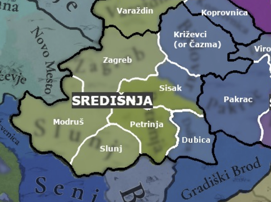
SRED.png

Središnja (Province): Short for “Središnja Hrvatska” in Croatian (“Central Croatia” in English), this region largely corresponds with the Croatian historical region of the same name. [1] I propose that this province contain 7 locations, some of which are extant in the draft shared last week and some of which are new: (i) “Zagreb”; (ii) “Križevci” or “Čazma”; (iii) “Sisak”; (iv) “Dubica”; (v) “Petrinja”; (vi) “Slunj”; and (vii) “Modruš”. I propose that “Zagreb” and “Dubica” remain unchanged but that the other locations included within this province undergo some changes and tweaks. Below, I’ve provided comments and supporting citations regarding those proposed changes.
  • Križevci” or “Čazma”: I propose dividing the current location of “Bjelovar” in two, with this northern region being renamed to either “Križevci” or “Čazma”. Much of the territory of this location overlaps with what is now called “Bjelovar”. However, while a sizeable town now and the namesake of a county of the modern republic of Croatia, as well as a place with a rich history in the early modern period, the town of Bjelovar does not appear to have been as significant within the region in 1337, with its earliest-known reference in historical records appearing in the early 1400s. [2] In contrast, the towns of Križevci and Čazma are both well-attested in the period at the start of the game, although Križevci grew relatively larger in the early modern and modern periods. [3][4] For example, only a few decades after the start of the game in 1397, the town of Križevci was important enough to host the so-called “Bloody Sabor,” an infamous meeting of the Sabor (i.e., the Croatian noble diet), where the Hungarian King Sigismund of Luxembourg murdered the Croatian Ban Stjepan Lacković and his followers. [3] Čazma, for its part, was listed in 1334 among 14 archdeaconries within the Diocese of Zagreb. [5] A map of Croatia during its personal union with Hungary in the mid-14th century, produced by historian Ferdo Šišić in 1918, also lists “Križevac” and Čazma as the only notable towns in the region. [6]
  • Sisak”: I propose that the southern half of the extant location “Bjelovar” and the northern portion of “Petrinja” be combined into a new location, “Sisak,” which include the town of the same name, and the territory surrounding the confluence of the Kupa, Sava, and Odra rivers. At this confluence of these three rivers, the town of “Sisak” has been an important hub for transport and trade in the region for millennia, including serving as the capital of the Roman province of Pannonia Savia and the seat of the Diocese of Sisak, which was later supplanted by the Diocese of Zagreb in the 1100s. [7] [5] [8] [16] While the town had declined in importance leading up to 1337, it remained an important trading center during this time and would later become the seat of a county in the 15th century. [7]
  • Modruš”: I propose that the eastern half of the extant location “Slunj” be carved out into a new location, “Modruš,” which include the town of the same name and the surrounding region to the north and west. The center of the powerful Frankapan family during the period, Modruš and the castle of Tržan above the settlement played an important role in the region from the late 1100s until the Ottoman conquest. [9]. After becoming a fiefdom of the Frankapans, the settlement grew rapidly, thanks to its position along the historic Ogulin-Senj road, which is depicted in this map of Croatia during the mid-14th century, produced by historian Ferdo Šišić in 1918. [6] The oldest Franciscan monastery in that part of Croatia was also founded in the area in 1378. [9] In 1553, Modruš became part of the Croatian Military Frontier, where it remained administratively until the 19th century. [9]
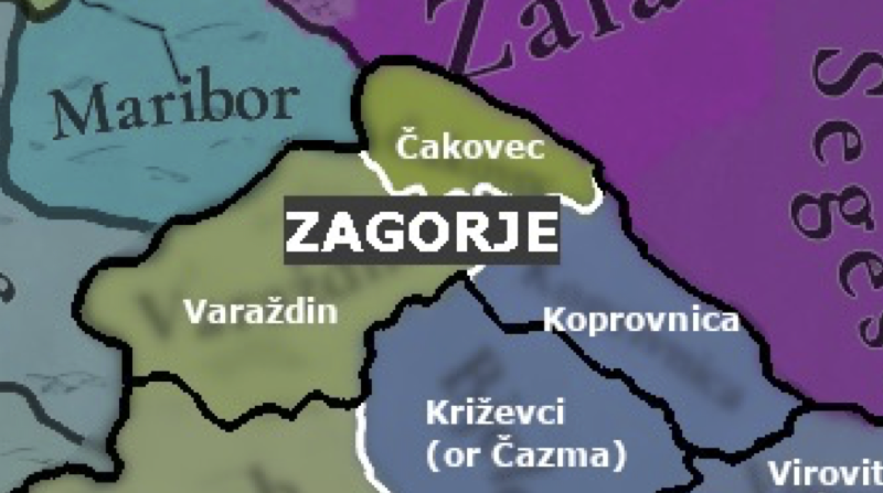
ZAG.png

Zagorje (Province): I suggest that a province of “Zagorje” be created that contains three already-existing locations along the watershed of the Drava, Sutla, and Mura rivers: (i) “Varaždin”; (ii) “Čakovec”; and (iii) “Koprivnica”. Meaning something like “behind the hills” in English, Zagorje is the name for the distinct geographical-historical region of northern Croatia. [10] Although the extant location called “Čakovec” may typically be excluded from this region, as it coexists with the different geographical-historical region of “Međimurje”, I think that grouping it into a three-location province would reflect the area’s unique position between Slovenia and Hungary without being too granular. [11]

Slavon.png

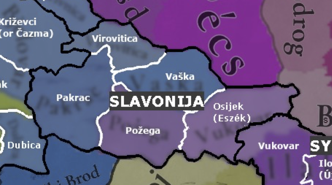
Slavonija (Province): I propose that a new province of “Slavonija” be created to replace most of what is currently labeled “Vukovar-Syrmia.” As one of the primary historical regions of Croatia, alongside other provinces already-present in the game (e.g., “Dalmatia” and “Istria”), I believe that it would make sense to include Slavonija as well. [12] I would propose that this new province include 5 locations, some of which are extant and some of which I propose to add: (i) “Virovitica”; (ii) “Pankrac”; (iii) “Požega”; (iv) “Vaska”; and (v) “Osijek”.
  • Osijek: For some reason, the forum's spam filter won't let me talk about Osijek in depth, so I'll just say that I recommend that it is included in the game.
  • Požega: I believe that the name and territory of the location “Požega” that currently appears in the game are good, but I suggest that the trade good for this location be changed to produce Wine. The location of “Požega” includes a Cistercian monastery that was founded in 1232 in the nearby town of Kutjevo, where monks produced wine until the monastery’s dissolution following the Ottoman conquest in the early 1500s. [15] While interrupted, winemaking at the location was renewed when Jesuits resettled the monastery in the late 1600s.
SYRM.png

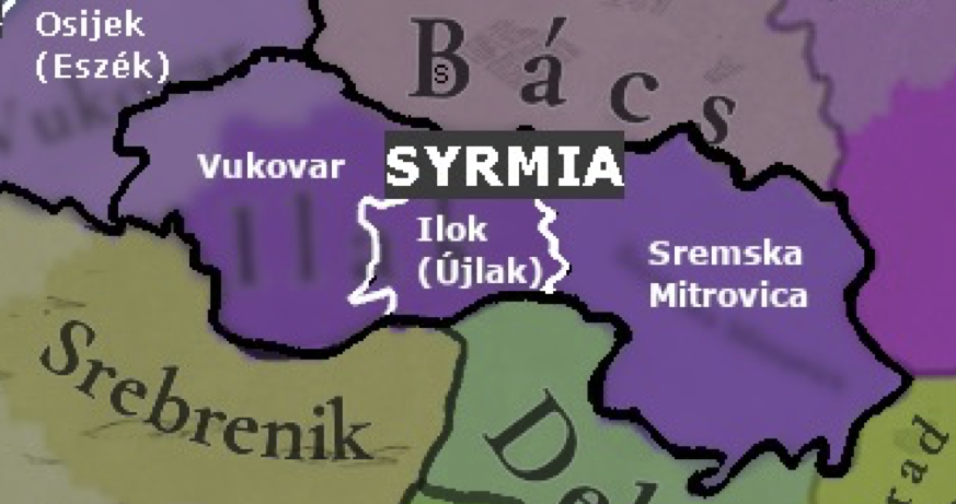
Syrmia (Province): I propose that a new province of “Syrmia” be created from a large portion of what is currently labeled “Vukovar-Syrmia”. This would represent the historical region between the Danube and Sava rivers that spands the border between modern Serbia and Croatia. I would suggest using the Latin “Syrmia” as opposed to either “Srem” or “Srijem” to avoid political-linguistic debates. [17] I suggest that this province include 3 locations, each of which already exist within the game, but would require minor tweaks in dimensions and name: (i) “Vukovar”; (ii) “Ilok”; and (iii) “Sremska Mitrovica”.
  • Vukovar: While “Vukovar” is an existing location in the game, I would suggest that the boundaries of the location be moved to include some of what is now “Ilak”. I would suggest that the northern border of the location “Vukovar” generally follow the course of the Vuka river, which terminates into the Danube at the city of Vukovar, and include the territories to the south. [13]
  • Ilok: I suggest changing the name of “Ilak” to “Ilok” when governed by south Slavic-speaking nations (“Újlak” in Hungarian).
References:
[1] “Zagrebačka makroregija,” Miroslav Krleža Institute of Lexicography, Hrvatska Enciklopedija (Online Edition).
[2] “Bjelovar,” Miroslav Krleža Institute of Lexicography, Hrvatska Enciklopedija (Online Edition).
[3] “Križevci,” Miroslav Krleža Institute of Lexicography, Hrvatska Enciklopedija (Online Edition).
[4] “Čazma,” Miroslav Krleža Institute of Lexicography, Hrvatska Enciklopedija (Online Edition).
[5] “Zagrebačka nadbiskupija,” Miroslav Krleža Institute of Lexicography, Hrvatska Enciklopedija (Online Edition).
[6] “HRVATSKA POLOVICOM XIV. VIJEKA,” Ferdo Šišić(1 December 1918).

Picture1.jpg

[7] “Sisak,” Miroslav Krleža Institute of Lexicography, Hrvatska Enciklopedija (Online Edition).
[8] “SISCIA (Sisak) Croatia, Yugoslavia,” The Princeton Encyclopedia of Classical Sites (Online Edition).
[9] “Modruš,” Miroslav Krleža Institute of Lexicography, Hrvatska Enciklopedija (Online Edition).
[10] “Hrvatsko zagorje,” Miroslav Krleža Institute of Lexicography, Hrvatska Enciklopedija (Online Edition).
[11] “Međimurje,” Miroslav Krleža Institute of Lexicography, Hrvatska Enciklopedija (Online Edition).
[12] “Slavonija,” Miroslav Krleža Institute of Lexicography, Hrvatska Enciklopedija (Online Edition).
[13] “Vukovar,” Miroslav Krleža Institute of Lexicography, Hrvatska Enciklopedija (Online Edition).
[14] “Osijek,” Miroslav Krleža Institute of Lexicography, Hrvatska Enciklopedija (Online Edition).
[15] “Kutjevo,” Euromed Heritage programme (2010).
[16] “Sisačka biskupija,” Miroslav Krleža Institute of Lexicography, Hrvatska Enciklopedija (Online Edition).
[17] “Srijem,” Miroslav Krleža Institute of Lexicography, Hrvatska Enciklopedija (Online Edition).
 
Last edited:
  • 10Like
  • 2
  • 1Love
  • 1
Reactions:
1720582707833.png

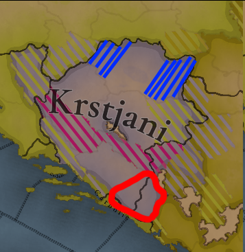
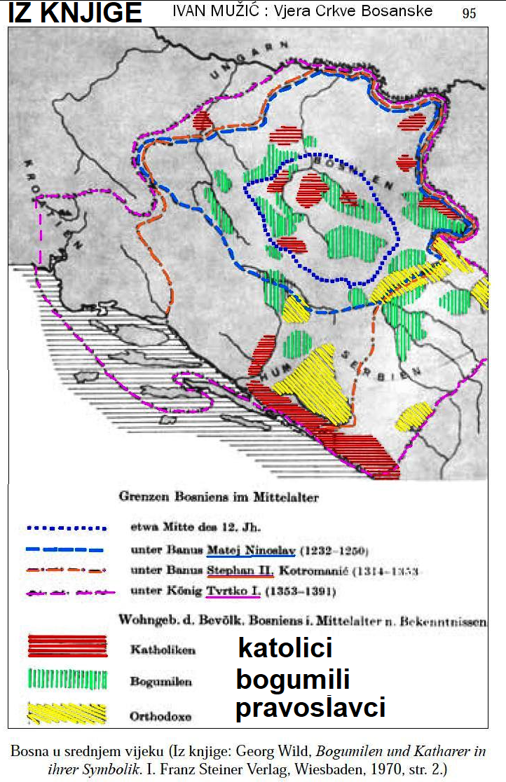
I'd like to add regarding the distribution of religions in Bosnia, the areas dashed with blue should have a sizeable catholic population and the area circled in red an orthodox majority.

Then again, this is hard to gauge due to a lack of census, all I can say with absolute certainty is that there should be a lot of mixture in the communities from location to location and the southernmost tip should be orthodox. My source is the map from Georg Wild (misidentifying the bosnian church as bogomil but I can forgive it that as it's from 1970).

1720583025106.png
 
  • 9Like
  • 2
  • 1
Reactions:
I've been reading wikipedia page on albanian conversion to islam and apperently there were pockets of Arianist heresy in albania all the way in 16th century, which slightly contributed to the fact they converted to islam, might be worth putting some sort of heretics there. Could be actually really cool to bring back Arianism back, would make for cool alt-scenarios/Achievments.

"Across Orthodox regions of Albania, conversion was also helped by the presence of heresies like Arianism and the fact that much of the Orthodox clergy was illiterate, corrupt, and conducted sermons in Greek, a foreign language, as well as the poverty of the Orthodox church."

source of this exact sentence: Giakoumis, Kosta (2010). "The Orthodox Church in Albania Under the Ottoman Rule, 15th- 19th Century". In Rathberger A. [ed.] (2010), ‘’Religion und Kultur im albanischschprachen sudosteuropen’’. Page 8-11

Entire article: https://en.wikipedia.org/wiki/Religion_in_Albania
 
  • 2
  • 1Like
  • 1Love
Reactions:
Serbs predominantly come to bosnia in The Great Migrations of the Serbs (Serbian: Велике сеобе Срба, romanized: Velike seobe Srba), also known as the Great Exoduses of the Serbs,[1] were two migrations of Serbs from various territories under the rule of the Ottoman Empire to the Kingdom of Hungary under the Habsburg monarchy.[2][3]


Before that bosnia was predominantly chatolic croats.
So Zavala monastery built in 1271 (Province of Herzegovina of Saint Sava or Hum, however you wanna call it), monasteries - Krupa na Vrbasu 13th century (Banja Luka, Republic of Srpska (bosnia in-game)) Gomionica 15th century (Banja Luka, Republic of Srpska), Црква Рођења Светог Јована Крститеља 13th century, Stuplje monastery 14th century, Radjevici , and some around Dalmatia: Krupa - Крупа (1317), Krka - Крка (1350) and Dragovic - Драговић (1395) they just fell from the sky? Maybe you think they were catapulted from Serbia, oh, I forgot you mentioned earlier that there was no Serbia in the Middle Ages, so I guess they fell from the sky.

As mentioned earlier, Serbian people lived in Bosnian region before the ottomans invaded. Even now you can find names of all Serbian Orthodox bishops who lived and served in Bosnia and they weren't there for some bogumils or "kristijani" or whatever you call them but for Serbian Orthodox population) and Serbian churches, Monasteries and castles were built a way before ottoman invasion. A lot of of Churches and Monasteries were plundered, burnt down or destroyed during the ottoman occupation and some by jihadists later, but most of them are still there.


Bishops of Dabar-Bosnia:
  • Hristofor (13th c.)
  • Joanikije (before 1292)
  • Metodije (end of 13th c.)
  • Nikola I (1284–1292)
  • Jovan I (?)
  • Spiridon (between 1286–1292)
  • Isaija I (1281–1291)
  • Jovan II (after 1286)
  • Jovan III (after 1286)
  • Isaija II (after 1286)
  • Gavrilo (13th c.)[7]
  • Jovan IV (1301–1317)
  • Nikolaj II (after 1317–before 1328)
  • Nikolaj III (before 1328-c. 1330)
  • Marko (c. 1532)
  • Varlam (c. 1557)
  • Simeon (c. 1573)
  • Nikanor (?)
  • Josif (died 15 May 1575)[8]
  • Gavrilo Avramović (1578–1588)[9]
  • Petronije (1578–1589)[10]
  • Aksentije (1589–1601)
  • Teodor (1601–1619)
  • Makarije (c. 1620)
  • Isaija (1627–1635)
  • Gavrilo Predojević (–1638)
  • Isaija II (1640–1655)
  • Longin (1656–1666)
  • Hristofor Pivljanin (1666–1681)
  • Atanasije Ljubojević (1681–1688)
  • Visarion II (1690–1708)
  • Isaija III (1708–1709)
  • Mojsije Petrović (1709–1713)
  • Meletije Umiljenović (1713–1740)
  • Gavrilo Mihailović (1741–1752)
  • Pajsije Lazarević (1752–1759)
  • Vasilije Jovanović Brkić (1760–1763)
  • Dionisije (1763?)
  • Serafim (1753-after 1790)
  • Danilo (c. 1769)
  • Kirilo (1776–1779)
  • Pajsije (before 1793–1802)
  • Kalinik (1808–1816)
  • Evgenije (1808?)
  • Venijamin (1816–1835)
  • Amvrosije Papa-Georgopolos (1835–1840)
  • Ignjatije (1841–1851)
  • Prokopije (1851–1856)
  • Dionisije (1856–1860)
  • Ignjatije II (1860–1868)
  • Dionisije II Ilijević (1868–1871)
  • Pajsije (1872–1874)
  • Antim (1874–1880)
  • Sava Kosanović (1881–1885)
  • Bishop Georgije (Nikolajević) (1885–1896)
  • Nikolaj Mandić (1896–1907)
  • Evgenije Letica (1908–1920)
  • Petar Zimonjić (1920–1941)
  • Nektarije Krulj (1951–1966)
  • Vladislav Mitrović (1967–1992)
  • Nikolaj Mrđa (1992–2015)
  • Grigorije Durić (2015–2017), administrator
  • Hrizostom Jević (2017-present)
 
Last edited:
  • 7Like
  • 3
  • 2Haha
  • 1
Reactions:
View attachment 1161365
I'd like to add regarding the distribution of religions in Bosnia, the areas dashed with blue should have a sizeable catholic population and the area circled in red an orthodox majority.

Then again, this is hard to gauge due to a lack of census, all I can say with absolute certainty is that there should be a lot of mixture in the communities from location to location and the southernmost tip should be orthodox. My source is the map from Georg Wild (misidentifying the bosnian church as bogomil but I can forgive it that as it's from 1970).

View attachment 1161366
There are monasteries from 13th century in Herzegovina, what bogumil church is there? Stephen changed his title to Herzeg of Saint Sava - and Herzegovina got its name Herzegovina of SAINT SAVA (Saint Sava was a Serbian Orthodox Archbishop)

"In 1377, Tvrtko Kotromanic was crowned King of Serbs of Bosnia in the presence of Sava's relics.[50] In 1448, Vojvoda Stefan Vukčić Kosača styled himself "herzog (duke) of Saint Sava"
 
  • 8Like
  • 2
  • 1Haha
Reactions:
damn every balkan map is gonna be a hell for moderator to get the threads clean
Yes, this inconsistency is huge. Even the Croats cannot decide how big the political territory of Croatia was in 1337. Some draw its political boundaries from the Austro-Hungarian period. But yes, this is only the political border of one country, let alone cultural borders, religious, etc.
 
  • 4Like
Reactions:
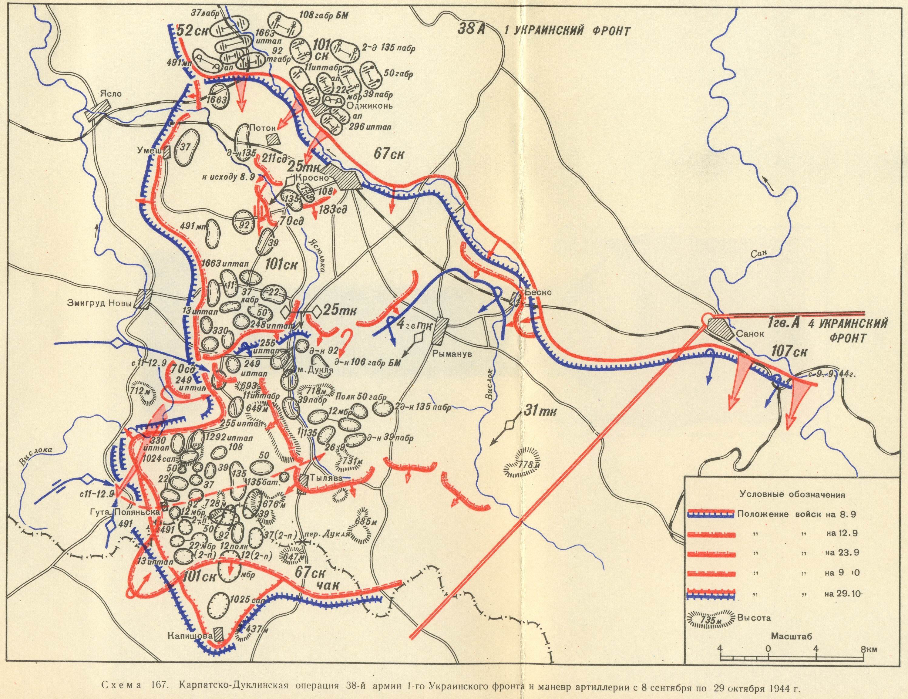
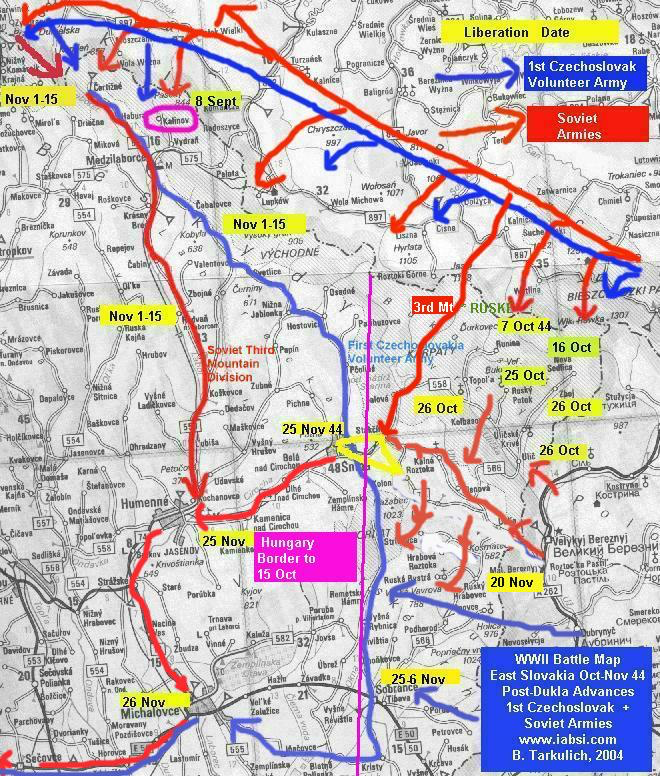
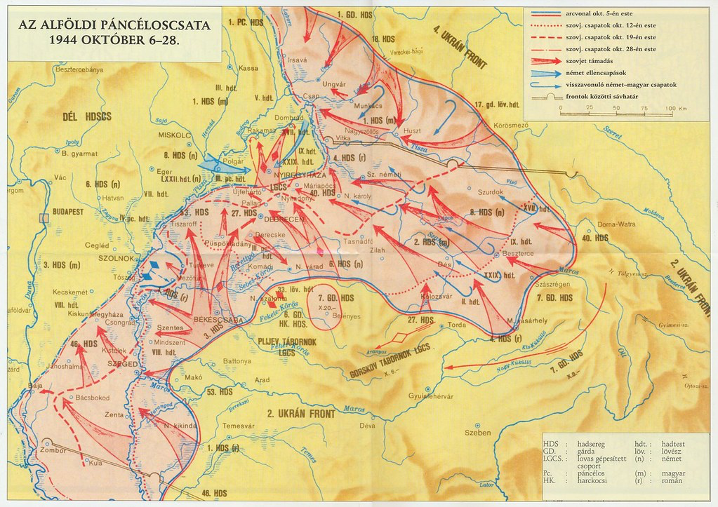
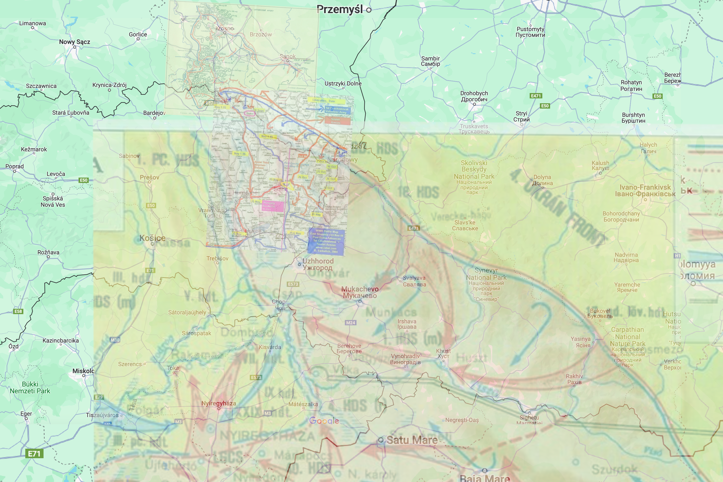
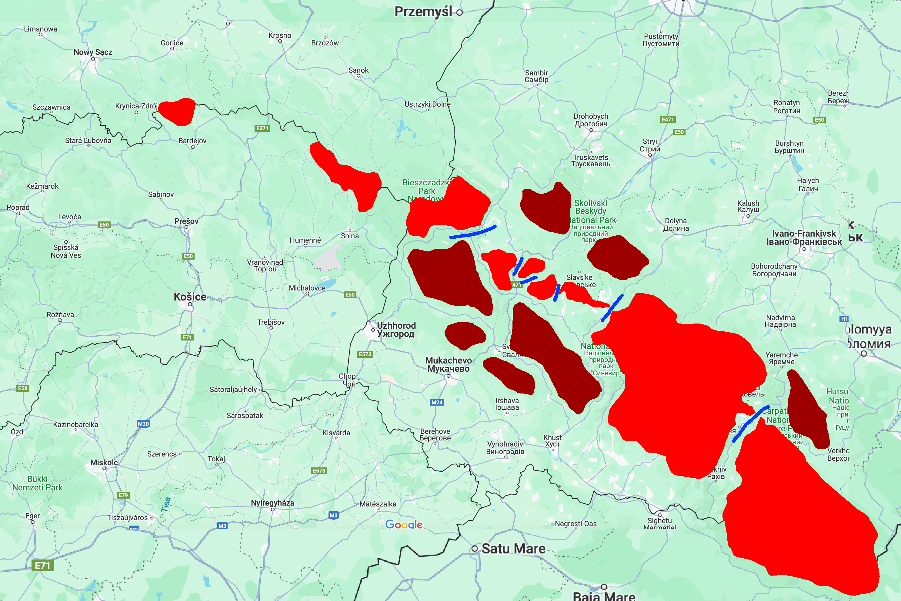
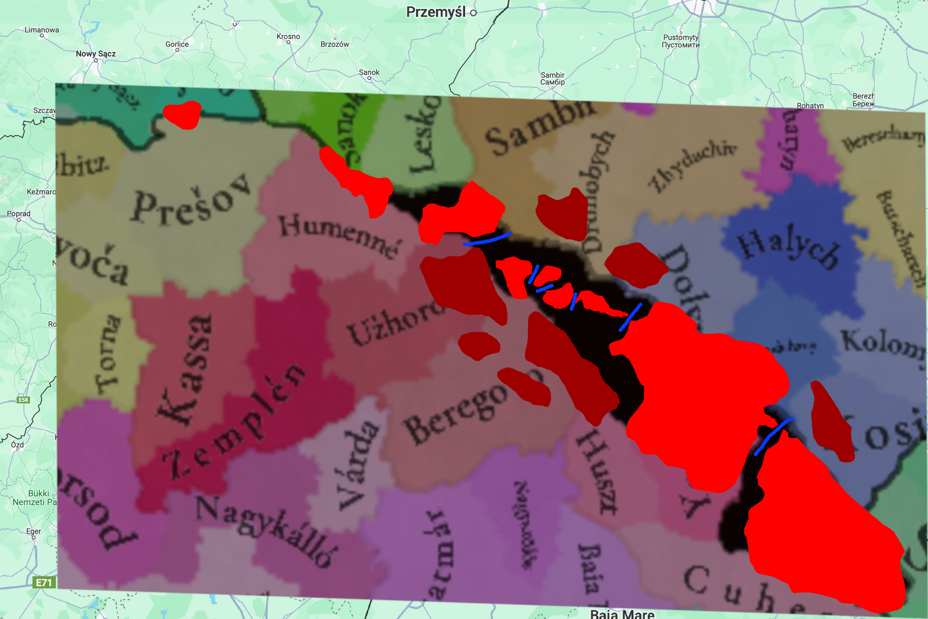
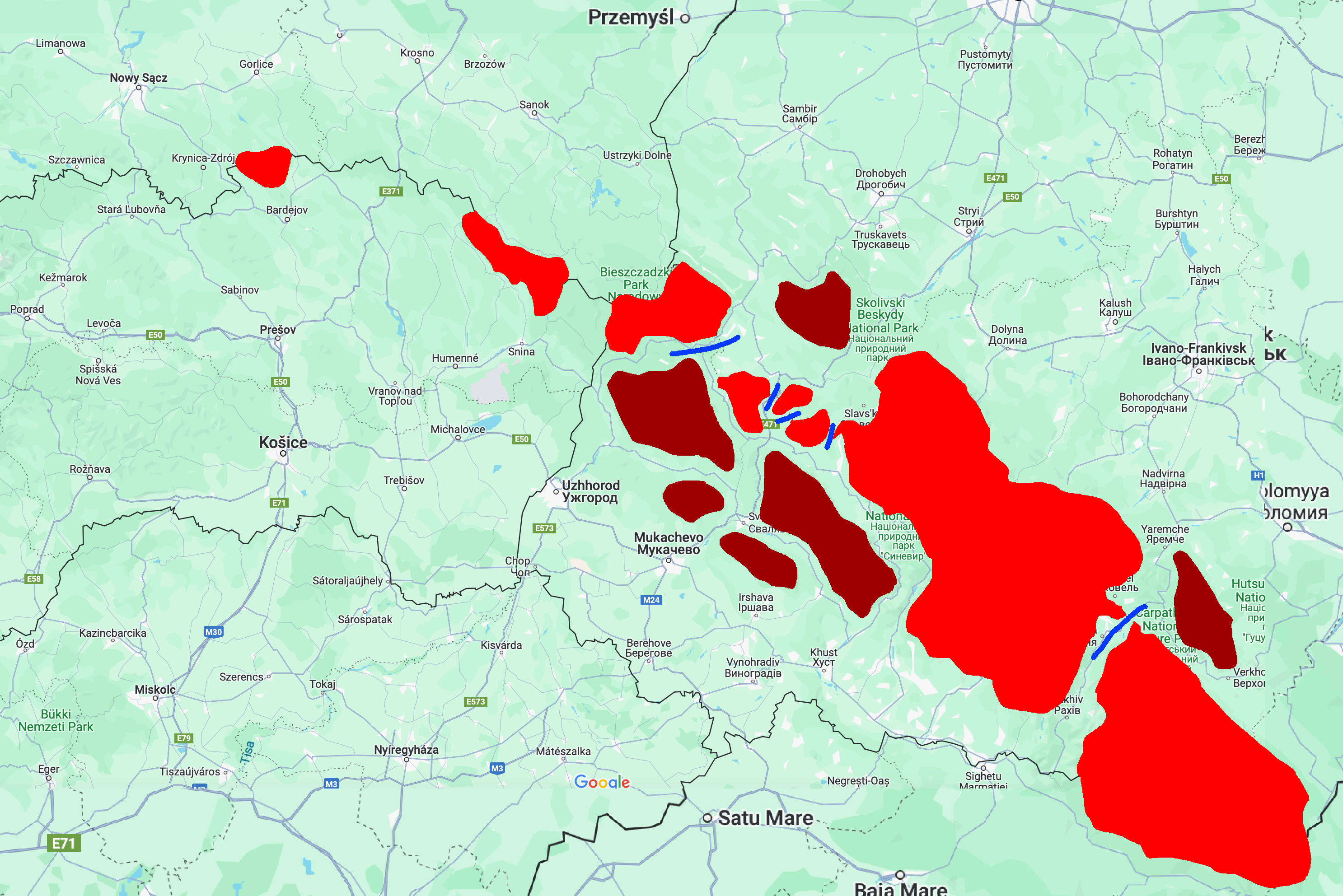
I'd like to make some suggestions concerning the Carpathian-Ruthenia area, specifically the impassable mountains there.

This is admittedly somewhat out of the timeline, but a possible way to determine the passability for armies of the region could be the Soviet operations in this region in late 1944.

http://iabsi.com/gen/public/military_post_dukla_soviet_offensive.htm
http://armchairgeneral.com/rkkaww2/maps/maps1944SW.htm#1UF_CZ
https://en.wikipedia.org/wiki/Uzhok_Pass
https://en.wikipedia.org/wiki/Veretskyi_Pass
https://en.wikipedia.org/wiki/Volovets_Pass
https://en.wikipedia.org/wiki/Yablunytsia_Pass
https://uk.wikipedia.org/wiki/Торунський_перевал
https://uk.wikipedia.org/wiki/Руська_Путь

1720592500897.png


1720589405579.png


1720592956963.png


1720592945377.png

Here are all of the potential impassable regions, some of which may not really have a point in being added since they would not change the graph of the map. Bright red vs dark red are the main ridge vs secondary ridges.

1720594043095.png


1720594084110.png


In this alternative map, I have kept just the passes mentioned in connection to at least one medieval historical military event

1720594072555.png
 
  • 14Like
  • 1
Reactions:
First, thanks so much for providing this opportunity to provide input! I’m a bit late to the game, but I have some suggestions (below) regarding the locations and provinces in inland Croatia and Slavonia that I hope you consider. I’ve included references to relevant materials where available, the citations for which can be found in an end note at the bottom of this submission, but some of the suggestions (e.g., border tweaks that do not run along rivers) involve a bit of guesswork. I believe that the proposal below would better highlight some of the region's unique culture and flavor, and are hopeful that you’ll consider it. Thanks again!

View attachment 1161284

Provinces: I suggest that the territories between the Drava and Sava rivers be divided into 4 provinces, which correspond with some of the distinct historical and cultural regions within the watershed: (i) “Središnja”; (ii) “Zagorje”; (iii) “Slavonija”; and (iv) “Syrmia”. Below, I’ve written more about why I believe each of these regions should be reflected as provinces and some of the suggested tweaks and changes to the location-level within them that I propose.

Središnja (Province): Short for “Središnja Hrvatska” in Croatian (“Central Croatia” in English), this region largely corresponds with the Croatian historical region of the same name. [1] I propose that this province contain 7 locations, some of which are extant in the draft shared last week and some of which are new: (i) “Zagreb”; (ii) “Križevci” or “Čazma”; (iii) “Sisak”; (iv) “Dubica”; (v) “Petrinja”; (vi) “Slunj”; and (vii) “Modruš”. I propose that “Zagreb” and “Dubica” remain unchanged but that the other locations included within this province undergo some changes and tweaks. Below, I’ve provided comments and supporting citations regarding those proposed changes.
  • Križevci” or “Čazma”: I propose dividing the current location of “Bjelovar” in two, with this northern region being renamed to either “Križevci” or “Čazma”. Much of the territory of this location overlaps with what is now called “Bjelovar”. However, while a sizeable town now and the namesake of a county of the modern republic of Croatia, as well as a place with a rich history in the early modern period, the town of Bjelovar does not appear to have been as significant within the region in 1337, with its earliest-known reference in historical records appearing in the early 1400s. [2] In contrast, the towns of Križevci and Čazma are both well-attested in the period at the start of the game, although Križevci grew relatively larger in the early modern and modern periods. [3][4] For example, only a few decades after the start of the game in 1397, the town of Križevci was important enough to host the so-called “Bloody Sabor,” an infamous meeting of the Sabor (i.e., the Croatian noble diet), where the Hungarian King Sigismund of Luxembourg murdered the Croatian Ban Stjepan Lacković and his followers. [3] Čazma, for its part, was listed in 1334 among 14 archdeaconries within the Diocese of Zagreb. [5] A map of Croatia during its personal union with Hungary in the mid-14th century, produced by historian Ferdo Šišić in 1918, also lists “Križevac” and Čazma as the only notable towns in the region. [6]
  • Sisak”: I propose that the southern half of the extant location “Bjelovar” and the northern portion of “Petrinja” be combined into a new location, “Sisak,” which include the town of the same name, and the territory surrounding the confluence of the Kupa, Sava, and Odra rivers. At this confluence of these three rivers, the town of “Sisak” has been an important hub for transport and trade in the region for millennia, including serving as the capital of the Roman province of Pannonia Savia and the seat of the Diocese of Sisak, which was later supplanted by the Diocese of Zagreb in the 1100s. [7] [5] [8] [16] While the town had declined in importance leading up to 1337, it remained an important trading center during this time and would later become the seat of a county in the 15th century. [7]
  • Modruš”: I propose that the eastern half of the extant location “Slunj” be carved out into a new location, “Modruš,” which include the town of the same name and the surrounding region to the north and west. The center of the powerful Frankapan family during the period, Modruš and the castle of Tržan above the settlement played an important role in the region from the late 1100s until the Ottoman conquest. [9]. After becoming a fiefdom of the Frankapans, the settlement grew rapidly, thanks to its position along the historic Ogulin-Senj road, which is depicted in this map of Croatia during the mid-14th century, produced by historian Ferdo Šišić in 1918. [6] The oldest Franciscan monastery in that part of Croatia was also founded in the area in 1378. [9] In 1553, Modruš became part of the Croatian Military Frontier, where it remained administratively until the 19th century. [9]

Zagorje (Province): I suggest that a province of “Zagorje” be created that contains three already-existing locations along the watershed of the Drava, Sutla, and Mura rivers: (i) “Varaždin”; (ii) “Čakovec”; and (iii) “Koprivnica”. Meaning something like “behind the hills” in English, Zagorje is the name for the distinct geographical-historical region of northern Croatia. [10] Although the extant location called “Čakovec” may typically be excluded from this region, as it coexists with the different geographical-historical region of “Međimurje”, I think that grouping it into a three-location province would reflect the area’s unique position between Slovenia and Hungary without being too granular. [11]

Slavonija (Province): I propose that a new province of “Slavonija” be created to replace most of what is currently labeled “Vukovar-Syrmia.” As one of the primary historical regions of Croatia, alongside other provinces already-present in the game (e.g., “Dalmatia” and “Istria”), I believe that it would make sense to include Slavonija as well. [12] I would propose that this new province include 5 locations, some of which are extant and some of which I propose to add: (i) “Virovitica”; (ii) “Pankrac”; (iii) “Požega”; (iv) “Vaska”; and (v) “Osijek”.
  • Osijek: For some reason, the forum's spam filter won't let me talk about Osijek in depth, so I'll just say that I recommend that it is included in the game.
  • Požega: I believe that the name and territory of the location “Požega” that currently appears in the game are good, but I suggest that the trade good for this location be changed to produce Wine. The location of “Požega” includes a Cistercian monastery that was founded in 1232 in the nearby town of Kutjevo, where monks produced wine until the monastery’s dissolution following the Ottoman conquest in the early 1500s. [15] While interrupted, winemaking at the location was renewed when Jesuits resettled the monastery in the late 1600s.

Syrmia (Province): I propose that a new province of “Syrmia” be created from a large portion of what is currently labeled “Vukovar-Syrmia”. This would represent the historical region between the Danube and Sava rivers that spands the border between modern Serbia and Croatia. I would suggest using the Latin “Syrmia” as opposed to either “Srem” or “Srijem” to avoid political-linguistic debates. [17] I suggest that this province include 3 locations, each of which already exist within the game, but would require minor tweaks in dimensions and name: (i) “Vukovar”; (ii) “Ilok”; and (iii) “Sremska Mitrovica”.
  • Vukovar: While “Vukovar” is an existing location in the game, I would suggest that the boundaries of the location be moved to include some of what is now “Ilak”. I would suggest that the northern border of the location “Vukovar” generally follow the course of the Vuka river, which terminates into the Danube at the city of Vukovar, and include the territories to the south. [13]
  • Ilok: I suggest changing the name of “Ilak” to “Ilok” when governed by south Slavic-speaking nations (“Újlak” in Hungarian).
References:
[1] “Zagrebačka makroregija,” Miroslav Krleža Institute of Lexicography, Hrvatska Enciklopedija (Online Edition).
[2] “Bjelovar,” Miroslav Krleža Institute of Lexicography, Hrvatska Enciklopedija (Online Edition).
[3] “Križevci,” Miroslav Krleža Institute of Lexicography, Hrvatska Enciklopedija (Online Edition).
[4] “Čazma,” Miroslav Krleža Institute of Lexicography, Hrvatska Enciklopedija (Online Edition).
[5] “Zagrebačka nadbiskupija,” Miroslav Krleža Institute of Lexicography, Hrvatska Enciklopedija (Online Edition).
[6] “HRVATSKA POLOVICOM XIV. VIJEKA,” Ferdo Šišić(1 December 1918).

[7] “Sisak,” Miroslav Krleža Institute of Lexicography, Hrvatska Enciklopedija (Online Edition).
[8] “SISCIA (Sisak) Croatia, Yugoslavia,” The Princeton Encyclopedia of Classical Sites (Online Edition).
[9] “Modruš,” Miroslav Krleža Institute of Lexicography, Hrvatska Enciklopedija (Online Edition).
[10] “Hrvatsko zagorje,” Miroslav Krleža Institute of Lexicography, Hrvatska Enciklopedija (Online Edition).
[11] “Međimurje,” Miroslav Krleža Institute of Lexicography, Hrvatska Enciklopedija (Online Edition).
[12] “Slavonija,” Miroslav Krleža Institute of Lexicography, Hrvatska Enciklopedija (Online Edition).
[13] “Vukovar,” Miroslav Krleža Institute of Lexicography, Hrvatska Enciklopedija (Online Edition).
[14] “Osijek,” Miroslav Krleža Institute of Lexicography, Hrvatska Enciklopedija (Online Edition).
[15] “Kutjevo,” Euromed Heritage programme (2010).
[16] “Sisačka biskupija,” Miroslav Krleža Institute of Lexicography, Hrvatska Enciklopedija (Online Edition).
[17] “Srijem,” Miroslav Krleža Institute of Lexicography, Hrvatska Enciklopedija (Online Edition).

These borders are too modern, and some of them are not even historical.
This was the case in 1444. Indeed, throughout history, especially after the invasion of the Ottoman Empire, the borders moved because Austria began to organize this area differently. Especially when war zones were emerging. So if we look at the borders of Slavonia, the dialect group of Kajkavian-speaking South Slavs are actually the original "Slavonians". Slavonia then, as already written, changed its border due to the wars and moved more to the east, and Croatia expanded to the north. There is a high probability that if there had been no Ottoman invasions, the political borders would not have changed either, at least not so drastically.
1720593887694.png
 
  • 9Like
  • 3
  • 2
Reactions:
Given Hungary's rather large locations, I have a suggestion for a much more broken down Hungary (sans Croatia). This one has almost 2x the locations, where provinces are based on individual (if large) or combined (if small) Counties. Included are location and elevation maps, with thicker lines signifying province boundaries.

View attachment 1161242

View attachment 1161243

NOTE 1: I based my division on the pre-Ottoman-invasion counties of Hungary, avoiding bordergore, following historical county borders whenever possible, geographical and ethnic borders otherwise, and borders from outside PC's timeframe if the first three principles weren't conclusive. That is, I didn't prioritize following modern borders, but there are very few places where I outright ignored them.
NOTE 2: I didn't consider trade goods, climate, or vegetation, so it may make sense to change up the exact layout for this or other reasons.
NOTE 3: The location names are in Hungarian for standardization, but they don't contain diacritics because that's too much effort.
NOTE 4: I followed the cultures presented by Tinto; however, I have a proposition for semi-dynamic culture in the works that would alter a couple of the cultures involved.
EDIT: NOTE 5: The exact spread of Hungarian marshes and floodplains is difficult to get data on, so this is my best estimation based on about two sources. It may make sense to turn a few of them into flatlands.
EDIT: NOTE 6: This is something like a 75% increase in number of locations, which makes me think that I went just a little overboard, so I think it's pretty reasonable to combine a few locations here and there.

Going through the map by areas and provinces, we have:

TRANSDANUBIA
Gyor-Sopron-Moson: combines three small adjacent counties (historically combined anyway post-WW1). Also includes ethnically Austrian lands in Kismarton (roughly following the modern border for convenience).
Vas: includes two flat Hungarian locations in Vas County, a largely Austrian and hilly Leka, and a largely Slovene and hilly Muraszombat (again, roughly following modern borders for convenience). NOTE: Muraszombat crosses over into IRL Zala County, which is also hilly Slovene; otherwise it would also be too small.
Zala: includes three locations in Zala County. Doesn't include the bit in Northern Croatia or the bit that went to Muraszombat.
Veszprem, Somogy, Tolna, Baranya: all four provinces follow historical counties of the same name.

DUNA
Komarom-Esztergom: combines two small adjacent counties (historically combined anyway post-WW1). While Komarom is split into two by the Danube, I chose to keep Esztergom as a single entity because otherwise it would be too small.
Pest: includes the core of Hungarian lands in Pest and Pilis counties (the two would be united early on). Does not include Solt (united halfway through the game) or Kiskun (united towards the end). I chose not to split Pilis into Buda+Obuda+Visegrad as all three of those would be painfully tiny. Rackeve should probably have some Cuman minorities, and potentially an event for a Serb migration if Ottomans expand into Serbia.
Nograd: consists of three locations within the historical Nograd County. Gacs should probably be mostly Slovak. Nograd should have at least a few Germans.
Fejer: consists of the pre-Ottoman Fejer County. This includes Solt and Kalocsa, which would be split off later. Szekesfehervar should probably have some Cuman minorities.

GREAT PLAIN
Bacs-Bogrod: includes the post-Ottoman-invasion Bacs-Bogrod county. It's reasonable to split the two, take out Zenta and add another location to Bacs/Titel, but I chose to not do that so that the map isn't full of small, 3-loc provinces as I have very little idea how that would impact gameplay. While all 6 should probably be majority Hungarian, there's a good chance that there were also significant Serbian minorities in the southern locations.
Csongrad-Csanad: includes the pre-Ottoman-invasion Csongrad and Csanad counties, which would be reshaped later at each other's expense. As with Bacs-Bogrod, it could be split in half while adding Zenta, but I chose not to for the same reason.
Kunsag-Szolnok: this includes four historical regions. It makes sense to place Kiskun and Nagykun together because both are majority Cuman, it makes sense to add Jaszsag to an area with significant ethnic minorities, it makes sense to stick Nagykun, Jaszsag, and Szolnok together because they would be united post-Ottoman-invasion, and it makes sense to have Szolnok with the rest because it's dead in the middle.
Bekes, Heves, Borsod: all three provinces follow counties of the same name. I strongly considered combining Heves and Borsod because both are relatively small, but I chose not to because there is no good historical precedent for it.
Szabolcs, Bihar: these two provinces follow pre-Ottoman-invasion borders. Later on, Hajdu would be split out from the two, but this wouldn't happen until the 1800s, so I chose to not include it as a separate province.

WEST SLOVAKIA
Pozsony: follows Pozsony County. Csallokoz should probably be an island, but I know that river bifurcations can be difficult to program. The culture should be a mix of Hungarian, Slovak, and German.
Nyitra: follows Nyitra County. All four should have Slovak populations, but there is an argument to be made that Nyitra should be mostly Hungarian.
Trencsen: follows Trencsen County; should be almost entirely Slovak.
Tatry: includes the three small counties of Turocz, Arva, and Lipto. I briefly considered combining them with Trencsen into a province named "Upper Vag" after the river, but that sounds like an entirely different thing (one that the vast majority of Paradox players would have no experience with). ;)
Garam: includes three counties that would otherwise have two locations each. Should be mostly Hungarian in the south, mostly Slovak in the north and center, with some scattered Germans in the mining towns.

EAST SLOVAKIA
Spis: this was a complicated one. Csurtortokhely includes most, but not all, of the Polish-controlled Spis mining towns, as well as an autonomous Ten Lance Bearers, and honestly the entire province could be broken down further if Tinto is okay with a small cluster of really small, bordergorey locations. The culture isn't much better, with Zipser Germans dominating individual towns but Slovaks dominating the countryside.
Saros: follows Saros County. Mostly Slovak, but with Zipser German minorities in all three, and Bartfa should have some Rusyns.
Gomor-Kishont: combines two small counties that would be united in 1802.
Abauj-Torna: combines two small counties that would be united several times in the 1800s.
Zemplen, Ung: follow their respective counties. Culturally mixed with Rusyns, Slovaks, Hungarians, and *maybe* a few Carpathian (Zipser?) Germans all present.

LOWER TRANSYLVANIA
Bereg: includes Bereg and Ugocsa counties. I considered combining it with Ung into a Transcarpathia province, but ultimately decided against it.
Maramaros, Szatmar: follow their respective counties.
Szilagy: combines the small Kraszna and Kozep-Szolnok counties (historically combined in 1876).
Doboka-Beszterce: combines three small-ish counties.

UPPER TRANSYLVANIA
Kolozs-Torda: combines Kolozs, Torda, and Aranyos counties. Culturally mixed, with a lot of Hungarians and Transylvanians, but also Transylvanian Germans in Szaszregen.
Feher-Kukullo: combines two small-ish counties. Culturally mixed.
Szekelyfold: covers Szekely Land (Csik, Udvarhely, Haromszek counties, which are themselves subdivided into locations based roughly on Szekely seats). Culture should be mostly Szekely, with some Transylvanian minorities.
Kiralyfold: covers land mostly inhabited by Transylvanian Germans (with Transylvanian minorities), plus Fogaras county and scattered parts of Feher.

BANAT
Hunyadi: follows Hunyadi County. Historically the cities have been Hungarian-majority, while the countryside is Romanian/Transylvanian; based on the low urbanization of the time period, I'd say that Transylvanian should be a majority.
Arad: includes Arad and Zarand counties, which were combined in 1744. The western part is Hungarian, while the eastern is mostly Transylvanian, with possibly some Serbs present.
Temes: includes Temes and Krasso counties. As these were completely rearranged in 1778 with a lot of land exchanging between the two, I thought it would make a lot of sense to combine the two into a single province. Culture is mixed, with Transylvanians in the northeast, Hungarians in the northwest, Serbs in the southwest, and even a chunk of Croatians in Krasso (the exact dates of Krashovani arrival is unclear but it seems to have been almost complete by 1337).
Torontal: includes Torontal and Keve counties. As Torontal was re-established to include Keve in 1779, the whole province is named after it. Torontal should be mostly Hungarian, the other two should be mostly Serbian, with minorities of the other in both.

@Pavía hopefully this will be of some inspiration for a rework.
Great proposal! I mostly have one minor problem with it: naming locations after areas, not settlement names.

While I'm all for naming provinces and such after the proper historical counties and regions they are inspired by, locations seem to be primarily settlements first and foremost. And especially in the case of extremely important cities and castles, such as Buda, the capital during the era, sometimes along with Visegrád (still in the same location), ommitting them in favour of something like Pilis is not very favourable and probably even detrimental to the immersion, in my opinion. So I think locations should be named after their settlements, when possible, in my opinion.

One other thing I think might be too much is the wetlands. It might be an overshoot in some regions such as around the central Tisza? But otherwise great proposal!
 
Last edited:
  • 2Like
  • 1
Reactions:
These borders are too modern, and some of them are not even historical.
This was the case in 1444. Indeed, throughout history, especially after the invasion of the Ottoman Empire, the borders moved because Austria began to organize this area differently. Especially when war zones were emerging. So if we look at the borders of Slavonia, the dialect group of Kajkavian-speaking South Slavs are actually the original "Slavonians". Slavonia then, as already written, changed its border due to the wars and moved more to the east, and Croatia expanded to the north. There is a high probability that if there had been no Ottoman invasions, the political borders would not have changed either, at least not so drastically.
View attachment 1161486

Would you please provide a reference date and source for the map used?
 
Some additional minor nitpicks, if it's not a problem;
TRANSDANUBIA
Gyor-Sopron-Moson: combines three small adjacent counties (historically combined anyway post-WW1). Also includes ethnically Austrian lands in Kismarton (roughly following the modern border for convenience).
Technically, today the united county uses the Győr-Moson-Sopron order, but I would probably be totally okay with just "Győr" because hyphenated names are long.
GREAT PLAIN
Bacs-Bogrod: includes the post-Ottoman-invasion Bacs-Bogrod county. It's reasonable to split the two, take out Zenta and add another location to Bacs/Titel, but I chose to not do that so that the map isn't full of small, 3-loc provinces as I have very little idea how that would impact gameplay. While all 6 should probably be majority Hungarian, there's a good chance that there were also significant Serbian minorities in the southern locations.
It is spelled Bodrog, bot Bogrod (it is not a rod in a bog); but I think if it's long a simple Bács or Bácska name would be sufficient enough.
Kunsag-Szolnok: this includes four historical regions. It makes sense to place Kiskun and Nagykun together because both are majority Cuman, it makes sense to add Jaszsag to an area with significant ethnic minorities, it makes sense to stick Nagykun, Jaszsag, and Szolnok together because they would be united post-Ottoman-invasion, and it makes sense to have Szolnok with the rest because it's dead in the middle.
So historically, the autonomous Kiskun, Nagykun and Jász seats were often referred to as the "Jászkun district" or "province". So I would vote for naming the province that specifically combines them all the Jászkun province.
BANAT
Hunyadi: follows Hunyadi County. Historically the cities have been Hungarian-majority, while the countryside is Romanian/Transylvanian; based on the low urbanization of the time period, I'd say that Transylvanian should be a majority.
Hunyad county is called Hunyad, not Hunyadi; the latter is the name of the family ("of Hunyad"); in Romanian it is called Hunedoara.

Cheers!
 
  • 3Like
Reactions:
I'm mega late, but better late than never I guess haha

Before I get into it, I wanna say that the game looks amazing so far, devs keep up the good work!!!!!

First, the border with Albania should be slightly fixed so that Dukagjini (dynamic name Dukađin) and Debar should be in Serbia.

1720602711863.png

1720603589974.png


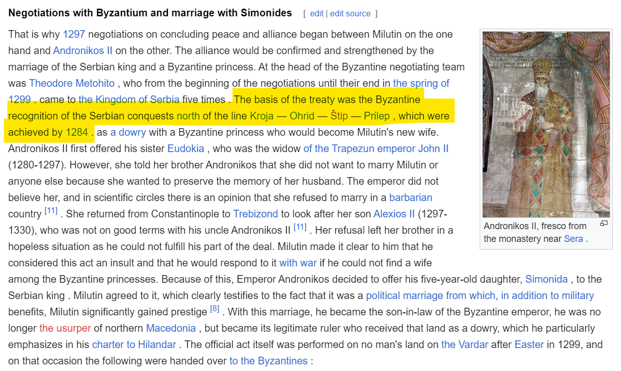
Second, the border with the Byzantines should be slightly changed. My guess is that Kočani and Strumica were assigned to Byzantium because of Hrelja (also sometimes Hreljo, Stefan Hrelyo, Stefan Dragovol...), who ruled the lands near these locations. However, his domain included Štip and Strumica, rather than Kočani, which belonged to Jovan Oliver at the time:

1720606124960.png

1720606181016.png

1720606225821.png


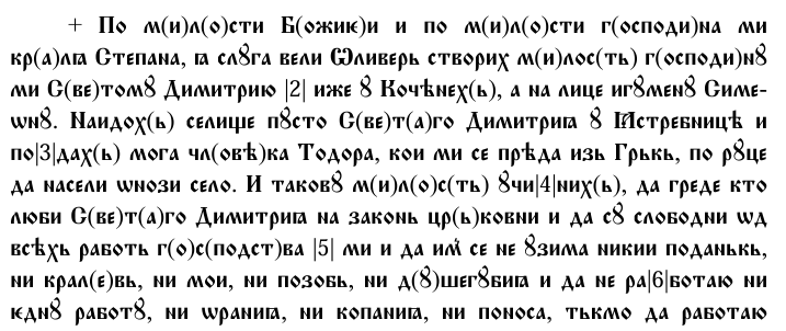
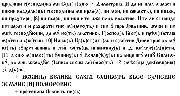
Hrelja, according to historical records, was a largely autonomous vassal under Stefan Dušan. In 1335, he built the Hrel tower in freshly renovated Rila monastery. On it, an inscription can be found, expressing his loyalty to Stefan Dušan:

1720604921672.png


Various sources cite his change of heart happening "in the late 1330s", but he most likely switched sides right before the Byzantine civil war (1341-1347) when Dušan fell ill (1340), taking the opportunity for his personal gains (John VI Kantakouzenos gifted Hrelja the location of Melnik in return for Hreljas support):

1720606347011.png


Third, the Serbian-Bulgarian border should also be modified so that Vidin/Bulgaria gets the Višesav, Koželj and Svrljig.

Lastly, here are some location names that need changing (red need changing, orange are dynamic Serbian names), and Serbia overall:

Locations.png


Serbia.png
 

Attachments

  • 1720605751196.png
    1720605751196.png
    152,3 KB · Views: 0
Last edited:
  • 2Like
  • 2
  • 2
Reactions:
I'm mega late, but better late than never I guess haha

Before I get into it, I wanna say that the game looks amazing so far, devs keep up the good work!!!!!

First, the border with Albania should be slightly fixed so that Dukagjini (dynamic name Dukađin) and Debar should be in Serbia.

View attachment 1161527
View attachment 1161539

Second, the border with the Byzantines should be slightly changed. My guess is that Kočani and Strumica were assigned to Byzantium because of Hrelja (also sometimes Hreljo, Stefan Hrelyo, Stefan Dragovol...), who ruled the lands near these locations. However, his domain included Štip and Strumica, rather than Kočani, which belonged to Jovan Oliver at the time:

View attachment 1161568
View attachment 1161570
View attachment 1161573

Hrelja, according to historical records, was a largely autonomous vassal under Stefan Dušan. In 1335, he built the Hrel tower in freshly renovated Rila monastery. On it, an inscription can be found, expressing his loyalty to Stefan Dušan:

View attachment 1161555

Various sources cite his change of heart happening "in the late 1330s", but he most likely switched sides right before the Byzantine civil war (1341-1347) when Dušan fell ill (1340), taking the opportunity for his personal gains (John VI Kantakouzenos gifted Hrelja the location of Melnik in return for Hreljas support):

View attachment 1161577

Third, the Serbian-Bulgarian border should also be modified so that Vidin/Bulgaria gets the Višesav, Kozelj and Svrljig.
Lastly, here are some location names that need changing (red need changing, orange are dynamic Serbian names), and Serbia overall:

View attachment 1161591
View attachment 1161599
After the fall of Branicevo under the Serbian king Stefan Milutin in 1290s Svrljig became a border region, it never came under Bulgarian rule again, the same goes for Kozelj
 
  • 2Like
  • 2
  • 2
  • 1Haha
Reactions: