• We have updated our Community Code of Conduct. Please read through the new rules for the forum that are an integral part of Paradox Interactive’s User Agreement.

Tinto Maps #9 - 5th of July 2024 - Carpathia and the Balkans

Greetings, and welcome to another Tinto Maps! This week we will be taking a look at Carpathia and the Balkans! It will most likely be an interesting region to take a look at, with a lot of passion involved… So I’ll just make an initial friendly reminder to keep a civil discussion, as in the latest Tinto Maps, as that’s the easiest way for us to read and gather your feedback, and improve the region in a future iteration. And now, let’s start with the maps!

Countries:
Countries.png

Carpathia and the Balkans start in a very interesting situation. The Kingdom of Hungary probably stands as the most powerful country in 1337, but that only happened after the recovery of the royal power enforced by Charles I Robert of the House of Anjou, who reined in the powerful Hungarian nobility. To the south, the power that is on the rise is the Kingdom of Serbia, ruled by Stefan Uroš IV Dušan, who has set his eyes on his neighbors to expand his power. The Byzantine Empire, meanwhile, is in a difficult position, as internal struggles ended in Andronikos III being crowned sole emperor, at the cost of dividing the realm; both Serbia and Bulgaria have in the past pressed over the bordering lands, while the Ottomans have very recently conquered Nicomedia. The control over the Southern Balkans is also very fractioned, with a branch of the Anjou ruling over Albania, the Despotate of Epirus under the nominal rule of Byzantium as a vassal, Athens, Neopatria and Salona as vassals of the Aragonese Kings of Sicily, Anjou protectorates over Achaia and Naxos, and only nominal Byzantine control over Southern Morea. It’s also noticeable the presence of the Republics of Venice and Genoa, which control several outposts over the Adriatic and Aegean Seas. A final note: in previous maps, Moldavia was shown in the map, but we’ve removed it from it, and it will most likely spawn through a chain of events in the 1340s.

Dynasties:
Dynasties.png

The House of Anjou rules over Naples, Hungary, Albania, Achaia, and Cephalonia; they’re truly invested in their push for supremacy over the region. Apart from that, each country is ruled by different dynasties, except for Athens and Neopatria, ruled by the House of Aragón-Barcelona.

Locations:
Locations 1.png

Locations 2.png

Locations 3.png

Locations 4.png
This week we’re posting the general map of the region, along with some more detailed maps, that can be seen if you click on the spoiler button. A starting comment is that the location density of Hungary is noticeably not very high; the reason is that it was one of the first European maps that we made, and we based it upon the historical counties. Therefore, I’m already saying in advance that this will be an area that we want to give more density when we do the review of the region; any help regarding that is welcome. Apart from that, you may notice on the more detailed maps that Crete appears in one, while not being present in the previous one; because of the zooming, the island will appear next week along with Cyprus, but I wanted to make an early sneak peek of the locations, given that is possible with this closer zoom level. Apart from that, I’m also saying in advance that we will make an important review of the Aegean Islands, so do not take them as a reference for anything, please.

Provinces:
Provinces.png

Provinces! Nothing outstanding to be commented on here; as usual, we’re open to any feedback regarding them.

Terrain:
Climate.png

Topography.png

Vegetation.png

Terrain! The climate of the region is mostly divided between Continental and Mediterranean, with some warmer and some colder regions. Regarding the topography, the Carpathian mountains are famously important and strategic, while the Balkans are a quite hilly and mountainous region, which is also greatly covered by woods and forests.

Cultures:
Cultures.png

Here comes the fun part of the DD: The cultural division of the Balkans! A few comments:
  1. Hungary is full of different minorities. Transylvania, especially, is an interesting place: there we have a mix of ‘Hungarians’, ‘Transylvanians’ (which are the Romanian-speaking inhabitants of the region), ‘Transylvanian Germans’, and ‘Szekely’ people.
  2. We have divided the Southern Slavic-speaking region into their dialectal families of Slovene, Croatian, Bosnian, and Serbian.
  3. The Southern Balkans are mostly divided among Bulgarian, Albanian, and Greek cultures.
  4. We’re also portraying plenty of other cultures, such as Dalmatians, Aromanians, Sclavenes, Arvanites, Cumans, Jasz, or Ashkenazi and Romanyoti Jews.

Religions:
Religion.png

This one is also interesting. Apart from the divide between Western Catholicism and Eastern Orthodoxy, we have the Krstjani in Bosnia, Bogomils (the pink stripes both in Bosnia and Macedonia), and Paulicians in Thrace. The Jewish populations do not pass the threshold percentage to appear on the map, but there are plenty of communities across the region.

Raw Materials:
Raw Materials.png

The materials of the region. Something very noticeable is the richness of minerals, with plenty of Iron, Copper, Tin, Lead, Gold, and Silver. Specifically, Slovakia is very rich, and you definitely want more settlers to migrate to the region, and exploit its resources. The region is also very rich in agricultural resources, as you can see.

Markets:
Markets.png

The region is mostly divided among four markets: Venice, Pest, Ragusa and Constantinople.

Country and Location population:
Population 1.png

Population 2.png

Population 3.png

Population 4.png
Country and location population (which I’ve also sub-divided, and is under the Spoiler button).

And that’s all of today! I hope that you find the region interesting; we certainly think that it is. Next week we will go further south, and we will take a look at the Syrian Levant and Egypt. Cheers!
 
  • 193Like
  • 69Love
  • 7
  • 4
  • 3
  • 1Haha
Reactions:
Great proposal! I mostly have one minor problem with it: naming locations after areas, not settlement names.

While I'm all for naming provinces and such after the proper historical counties and regions they are inspired by, locations seem to be primarily settlements first and foremost. And especially in the case of extremely important cities and castles, such as Buda, the capital during the era, sometimes along with Visegrád (still in the same location), ommitting them in favour of something like Pilis is not very favourable and probably even detrimental to the immersion, in my opinion. So I think locations should be named after their settlements, when possible, in my opinion.

One other thing I think might be too much is the wetlands. It might be an overshoot in some regions such as around the central Tisza? But otherwise great proposal!
The reason I chose to name it Pilis is that naming it Visegrad would omit Buda, naming it Buda would omit Visegrad, and naming it Buda-Visegrad after two locations at once sounds silly when you can name it after the county. Additionally, the devs had no problem naming locations after counties in the first pass, so why would they in the rework?
I pointed out the potential overshoot of wetlands in the notes already; it's hard to get exact data on it so they could reasonably be cut down a little bit (or expanded, for all I know).
 
  • 2Like
Reactions:
Some additional minor nitpicks, if it's not a problem;

Technically, today the united county uses the Győr-Moson-Sopron order, but I would probably be totally okay with just "Győr" because hyphenated names are long.

It is spelled Bodrog, bot Bogrod (it is not a rod in a bog); but I think if it's long a simple Bács or Bácska name would be sufficient enough.

So historically, the autonomous Kiskun, Nagykun and Jász seats were often referred to as the "Jászkun district" or "province". So I would vote for naming the province that specifically combines them all the Jászkun province.

Hunyad county is called Hunyad, not Hunyadi; the latter is the name of the family ("of Hunyad"); in Romanian it is called Hunedoara.

Cheers!
Fixed Hunyad and Bodrog (think I spent too much time staring at Borsod and accidentally made them sound similar lol), thanks for the catches! Debating Gyor, might even rename it Ferto after the lake or something. Can't find anything on "Jaszkun" at a quick glance, could you link sources?
 
The reason I chose to name it Pilis is that naming it Visegrad would omit Buda, naming it Buda would omit Visegrad, and naming it Buda-Visegrad after two locations at once sounds silly when you can name it after the county. Additionally, the devs had no problem naming locations after counties in the first pass, so why would they in the rework?
I pointed out the potential overshoot of wetlands in the notes already; it's hard to get exact data on it so they could reasonably be cut down a little bit (or expanded, for all I know).
In the past? You mean other games, like EU4?

Pretty sure the devs are aiming for villages/towns/cities/castles when naming locations for this game.

Both Visegrad and Buda are possible if there is some reshuffling/redrawing of the borders and all that.
 
  • 2Like
Reactions:
So Zavala monastery built in 1271 (Province of Herzegovina of Saint Sava or Hum, however you wanna call it), monasteries - Krupa na Vrbasu 13th century (Banja Luka, Republic of Srpska (bosnia in-game)) Gomionica 15th century (Banja Luka, Republic of Srpska), Црква Рођења Светог Јована Крститеља 13th century, Stuplje monastery 14th century, Radjevici , and some around Dalmatia: Krupa - Крупа (1317), Krka - Крка (1350) and Dragovic - Драговић (1395) they just fell from the sky? Maybe you think they were catapulted from Serbia, oh, I forgot you mentioned earlier that there was no Serbia in the Middle Ages, so I guess they fell from the sky.

As mentioned earlier, Serbian people lived in Bosnian region before the ottomans invaded. Even now you can find names of all Serbian Orthodox bishops who lived and served in Bosnia and they weren't there for some bogumils or "kristijani" or whatever you call them but for Serbian Orthodox population) and Serbian churches, Monasteries and castles were built a way before ottoman invasion. A lot of of Churches and Monasteries were plundered, burnt down or destroyed during the ottoman occupation and some by jihadists later, but most of them are still there.
All those monastaries and then name 1 before 1337 others are 14 century and later. But yeah i forgot it was serbs and then amebas

Some serbs were acepted into Bosnia by king Tomislav of croatia when saving serbs from Bulgarian onslaught, so some were present in bosnia im not denaying that. But not in majority or in overwhelming numbers how modern serbian nationalists present it.
Also for some of those monastraries they were old chatolic one that were usupred by orthodox church
King Tomislav did do, after Serbia was conquered by Bulgaria, was to give asylum to Serbian refugees led by their Prince Zaharija https://en.m.wikipedia.org/wiki/Croatian–Bulgarian_battle_of_926
and thats origins of serbs in bosnia
 
  • 5Like
  • 4
  • 1Haha
Reactions:
The reason I chose to name it Pilis is that naming it Visegrad would omit Buda, naming it Buda would omit Visegrad, and naming it Buda-Visegrad after two locations at once sounds silly when you can name it after the county. Additionally, the devs had no problem naming locations after counties in the first pass, so why would they in the rework?
I pointed out the potential overshoot of wetlands in the notes already; it's hard to get exact data on it so they could reasonably be cut down a little bit (or expanded, for all I know).
Personally I would split Buda to Visegrád and Buda, but those would probably be very small (though, with a little cheating, it is possible to make them stay in a size range that is precedented in some high-density areas, such as around Vienna). Still, I think it would be more immersive if the capital was named after at the very least one of them, Buda, if both are not possible, than after some hilly area most non-Hungarian players have never heard of.

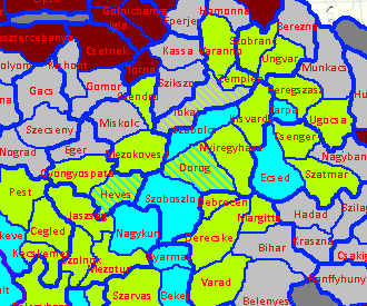
About marshes; while some areas, like Heves, Szabolcs, and Zemplén could be decreased or changed around, like Sátoraljaújhely replaced with Tokaj (and given Wine goods) or Sárospatak, and potentially made either into hills or plains; but I could totally see for example Nagykároly (even though an important settlement in the area) replaced by Ecsed, a seat of the illustrious Báthory family alongside the nearby Nyírbátor (although that's in the Nyírség area, just over the "border" with Nyíregyháza here), and made into a marsh, as a homage to the Ecsed Bog, a large boggy area around the castle of Ecsed near Károly that proved a considerable defense. This isn't a necessary change and Károly is fine too, but I think it would be a neat addition to add the home of the Báthorys, who were a very powerful dynasty from the 15th century onward (providing multiple Voivodes of Transylvania, Princes of Transylvania, and even a King of Poland).

1720620978126.png

Fixed Hunyad and Bodrog (think I spent too much time staring at Borsod and accidentally made them sound similar lol), thanks for the catches! Debating Gyor, might even rename it Ferto after the lake or something. Can't find anything on "Jaszkun" at a quick glance, could you link sources?
Unfortunately I do not have English sources, but the term exists in Hungarian in both colloquial and academic sources, here is the Hungarian Wikipedia page for the so-called Jászkun district, or "Jászkunság", which really is just a term for the two areas together.
 
  • 3Like
  • 2Love
Reactions:
I am very disappointed because I no longer see Serbian population on the map... I would like to remind you that in 1355 Serbia became an Empire with its capital in Skopje, which on this map does not show any Serbs. I also see some Albanians in Kosovo... It is both tragic and comical how disconnected this is from reality. Until the arrival of the Turks in the Balkans, there were almost no Albanians in Kosovo. Today the situation is different, but I hope you can at least make some effort regarding historical data. The truth is that this topic personally affects me because my family was expelled from the Kosovo Vilayet in 1736 precisely because we did not want to become Albanianized and convert to Islam.

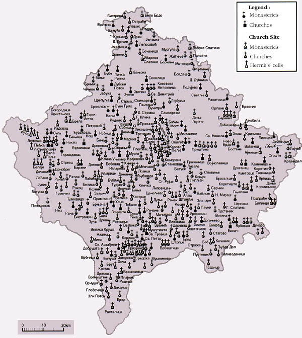
I WOULD ALSO LIKE TO ASK YOU TO LOOK AT THE MAP OF SERBIAN ORTHODOX CHURCHES IN KOSOVO BECAUSE WHEN YOU SEE IT, YOU WILL SEE THAT THERE ARE ABOUT 1,300 CHURCHES AND MONASTERIES, AND YOU WILL REALIZE THAT KOSOVO IS ACTUALLY THE CENTER OF SERBIAN CULTURE.
 
  • 6Like
  • 6
  • 3Haha
  • 3
Reactions:
About marshes; while some areas, like Heves, Szabolcs, and Zemplén could be decreased or changed around, like Sátoraljaújhely replaced with Tokaj (and given Wine goods) or Sárospatak, and potentially made either into hills or plains; but I could totally see for example Nagykároly (even though an important settlement in the area) replaced by Ecsed, a seat of the illustrious Báthory family alongside the nearby Nyírbátor (although that's in the Nyírség area, just over the "border" with Nyíregyháza here), and made into a marsh, as a homage to the Ecsed Bog, a large boggy area around the castle of Ecsed near Károly that proved a considerable defense. This isn't a necessary change and Károly is fine too, but I think it would be a neat addition to add the home of the Báthorys, who were a very powerful dynasty from the 15th century onward (providing multiple Voivodes of Transylvania, Princes of Transylvania, and even a King of Poland).
Yeah… ideally I would have split Satoraljaulhely into two halves along the river, with one half being marsh and the other half being hills, but there was already a lot of location bloat and also I’d have ended up with two *really* skinny locations.
 
  • 2Like
  • 1
Reactions:
1000016152.jpg

Here is just a SMALL part of the Serbian churches and monasteries in Kosovo. However, I hope this gives you a good insight into the fact that 95% of the inhabitants were Serbs. I would also like to emphasize that Prizren was the "capital city" of Stefan Uroš IV Dušan Nemanjić, while Skopje was the city where he proclaimed himself Emperor. Please take care of these details.
 
  • 7
  • 5
  • 1Like
  • 1Haha
  • 1
Reactions:
View attachment 1161720
Here is just a SMALL part of the Serbian churches and monasteries in Kosovo. However, I hope this gives you a good insight into the fact that 95% of the inhabitants were Serbs. I would also like to emphasize that Prizren was the "capital city" of Stefan Uroš IV Dušan Nemanjić, while Skopje was the city where he proclaimed himself Emperor. Please take care of these details.
I have no Idea if there were any Albanians at all in Kosovo in 1337, but you realize, that Albanians were Christians (Orthodox) back then, and probably used churches built by other cultures (among others).
 
  • 10Like
  • 1Haha
Reactions:
Yeah… ideally I would have split Satoraljaulhely into two halves along the river, with one half being marsh and the other half being hills, but there was already a lot of location bloat and also I’d have ended up with two *really* skinny locations.
yeah... it's unfortunate, because the border between Zemplén and Szabolcs is technically the Tisza, not the Bodrog (the river that flows into the Tisza at Tokaj, not to be confused with the county of the same name), so that wetlands of the Bodrogköz (the swampy area at the crossing of the Tisza and Bodrog at the border of Zemplén and Szabolcs) is part of Zemplén rather than Szabolcs. Honestly there is no good workaround except for extreme granularity, so I'm completely fine with either Sátoraljaújhely (or Újhely (it appears as Ujhel on Tabula Hungariae), before that it was also called Sátorhalma, but "Saturala Wyhel" (its modern form) already existed by 1300, so really any version goes; however, "Aljaújhely", the form you used, is not one I can find attested anywhere and it also doesn't make a lot of sense grammatically, so it probably should be any of the aforementioned forms instead), or Sárospatak as marshes, or Tokaj as hills, or plains, or marshes, really.
 
Last edited:
  • 3Like
Reactions:
About marshes; while some areas, like Heves, Szabolcs, and Zemplén could be decreased or changed around, like Sátoraljaújhely replaced with Tokaj (and given Wine goods) or Sárospatak, and potentially made either into hills or plains; but I could totally see for example Nagykároly (even though an important settlement in the area) replaced by Ecsed, a seat of the illustrious Báthory family alongside the nearby Nyírbátor (although that's in the Nyírség area, just over the "border" with Nyíregyháza here), and made into a marsh, as a homage to the Ecsed Bog, a large boggy area around the castle of Ecsed near Károly that proved a considerable defense. This isn't a necessary change and Károly is fine too, but I think it would be a neat addition to add the home of the Báthorys, who were a very powerful dynasty from the 15th century onward (providing multiple Voivodes of Transylvania, Princes of Transylvania, and even a King of Poland).
1720643493939.png

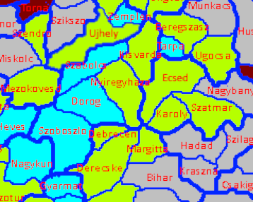
Ecsed is on the Csenger side of the Csenger-Karoly border, so something like this perhaps? Here, Ujhely is flat as an average of SE marshes and NW hills. Alternatively, I could put a wasteland between Szikszo and Ujhely, but I think that's too extreme of a representation of the hills.
This still has Heves and Dorog as marsh and Ecsed as flatlands, but that's due to being lower priority so that can be changed. Ecsed in particular is unclear to me, as Nyirseg seems to be at a higher elevation than Csenger and the Tisza floodplain, and there's no convenient way to split it in two (in theory I could give Karoly the western half of Ecsed, but I'm reluctant to do so for the moment).
 
Last edited:
  • 2Like
  • 1
Reactions:
Why should Dobruja have Romanian name places when it's ruled by Bulgaria and is majority Bulgarian (well depending on who we are asking, northern Dobruja was very mixed, but adding onto the fact that it was ruled by Bulgarians for SO long and during the time of the start date, it shouldn't have Romanian name-places.)
 
  • 4Like
  • 3
  • 1
Reactions:
Why should Dobruja have Romanian name places when it's ruled by Bulgaria and is majority Bulgarian (well depending on who we are asking, northern Dobruja was very mixed, but adding onto the fact that it was ruled by Bulgarians for SO long and during the time of the start date, it shouldn't have Romanian name-places.)
Dynamic province-naming is still in the works.
 
  • 4Like
Reactions:
Why should Dobruja have Romanian name places when it's ruled by Bulgaria and is majority Bulgarian (well depending on who we are asking, northern Dobruja was very mixed, but adding onto the fact that it was ruled by Bulgarians for SO long and during the time of the start date, it shouldn't have Romanian name-places.)
There was a big Post with name suggestions for locations ruled by Bulgaria in the first pages of this discussion. I also made a couple of suggestions already.
 
  • 1Like
Reactions:
"you definitely want more settlers to migrate to the region,"

I may have missed this in other DDs, but does this mean there is no button press development/ population system like eu4, but its more akin to Meiou and Taxes?
 
Dear TintoTalks,

As a Hungarian (and historian) I would like to share you some minor (but significant) erros. The province called "Budapest" is wrong, Budapest as a city was created in 1873 from the unification of Buda, Pest and Óbuda. It should be renamed, or split it at the Danube river to Pest and Buda provinces. Although the two cities were economically attached to eachother. Pest was more like on plains (significant livestock, crafts) and Buda is on hills (significant wine production).

The province called "Bácsa" is wrong, it is "Bács", instead of "Banat" it is "Bánság"

The location names are very bad. Nobody every called these locations in Slovakian or Romanian in Transylvania and todays Slovakia before 1920. Those names are transmitted from the Hungarian names. For example: Făgăraș is from the Hungarian name Fogaras or Trenčín is from Trencsén. So please change all of the Hungarian location names to Hungarian, instead of historical anachronism. -- If you need help with that, I can list you the locations with their actual name, feel free to contact me.

The name "Koloszvár" is wrong, it is "Kolozsvár", flip the "s" and "z" letters.
 
  • 10
  • 4Like
  • 1
Reactions:
I am very disappointed because I no longer see Serbian population on the map... I would like to remind you that in 1355 Serbia became an Empire with its capital in Skopje, which on this map does not show any Serbs. I also see some Albanians in Kosovo... It is both tragic and comical how disconnected this is from reality. Until the arrival of the Turks in the Balkans, there were almost no Albanians in Kosovo. Today the situation is different, but I hope you can at least make some effort regarding historical data. The truth is that this topic personally affects me because my family was expelled from the Kosovo Vilayet in 1736 precisely because we did not want to become Albanianized and convert to Islam.

I WOULD ALSO LIKE TO ASK YOU TO LOOK AT THE MAP OF SERBIAN ORTHODOX CHURCHES IN KOSOVO BECAUSE WHEN YOU SEE IT, YOU WILL SEE THAT THERE ARE ABOUT 1,300 CHURCHES AND MONASTERIES, AND YOU WILL REALIZE THAT KOSOVO IS ACTUALLY THE CENTER OF SERBIAN CULTURE.
- Churches, monasteries, fortresses, and other Serbian cultural monuments, while there is no trace of albanians, they do not have a single one cultural monument, church, grave or anything else in the provinces of Kosovo and Metohija in the 14th century. It's just another historical revisionism and continuity of ignorance, so we cannot expect anything else but Paradox to please the minority of the players - this forum's ignorant and toxic community, because a majority of the players enjoy Paradox games - do not waste time on this forum. I have played Paradox games for 15 years already but didn't check forum at all unless I got into some bugs or other issues and now when I got tired of watching this historical revisionism.

EU IV will be the last Paradox game ever that I bought, I am not going to support lies and historical revisionism. Before they used to say "It's about balance" but now it's clear that was nothing but an excuse
 
  • 10
  • 5Haha
  • 4
  • 1Like
Reactions: