• We have updated our Community Code of Conduct. Please read through the new rules for the forum that are an integral part of Paradox Interactive’s User Agreement.

Tinto Maps #9 - 5th of July 2024 - Carpathia and the Balkans

Greetings, and welcome to another Tinto Maps! This week we will be taking a look at Carpathia and the Balkans! It will most likely be an interesting region to take a look at, with a lot of passion involved… So I’ll just make an initial friendly reminder to keep a civil discussion, as in the latest Tinto Maps, as that’s the easiest way for us to read and gather your feedback, and improve the region in a future iteration. And now, let’s start with the maps!

Countries:
Countries.png

Carpathia and the Balkans start in a very interesting situation. The Kingdom of Hungary probably stands as the most powerful country in 1337, but that only happened after the recovery of the royal power enforced by Charles I Robert of the House of Anjou, who reined in the powerful Hungarian nobility. To the south, the power that is on the rise is the Kingdom of Serbia, ruled by Stefan Uroš IV Dušan, who has set his eyes on his neighbors to expand his power. The Byzantine Empire, meanwhile, is in a difficult position, as internal struggles ended in Andronikos III being crowned sole emperor, at the cost of dividing the realm; both Serbia and Bulgaria have in the past pressed over the bordering lands, while the Ottomans have very recently conquered Nicomedia. The control over the Southern Balkans is also very fractioned, with a branch of the Anjou ruling over Albania, the Despotate of Epirus under the nominal rule of Byzantium as a vassal, Athens, Neopatria and Salona as vassals of the Aragonese Kings of Sicily, Anjou protectorates over Achaia and Naxos, and only nominal Byzantine control over Southern Morea. It’s also noticeable the presence of the Republics of Venice and Genoa, which control several outposts over the Adriatic and Aegean Seas. A final note: in previous maps, Moldavia was shown in the map, but we’ve removed it from it, and it will most likely spawn through a chain of events in the 1340s.

Dynasties:
Dynasties.png

The House of Anjou rules over Naples, Hungary, Albania, Achaia, and Cephalonia; they’re truly invested in their push for supremacy over the region. Apart from that, each country is ruled by different dynasties, except for Athens and Neopatria, ruled by the House of Aragón-Barcelona.

Locations:
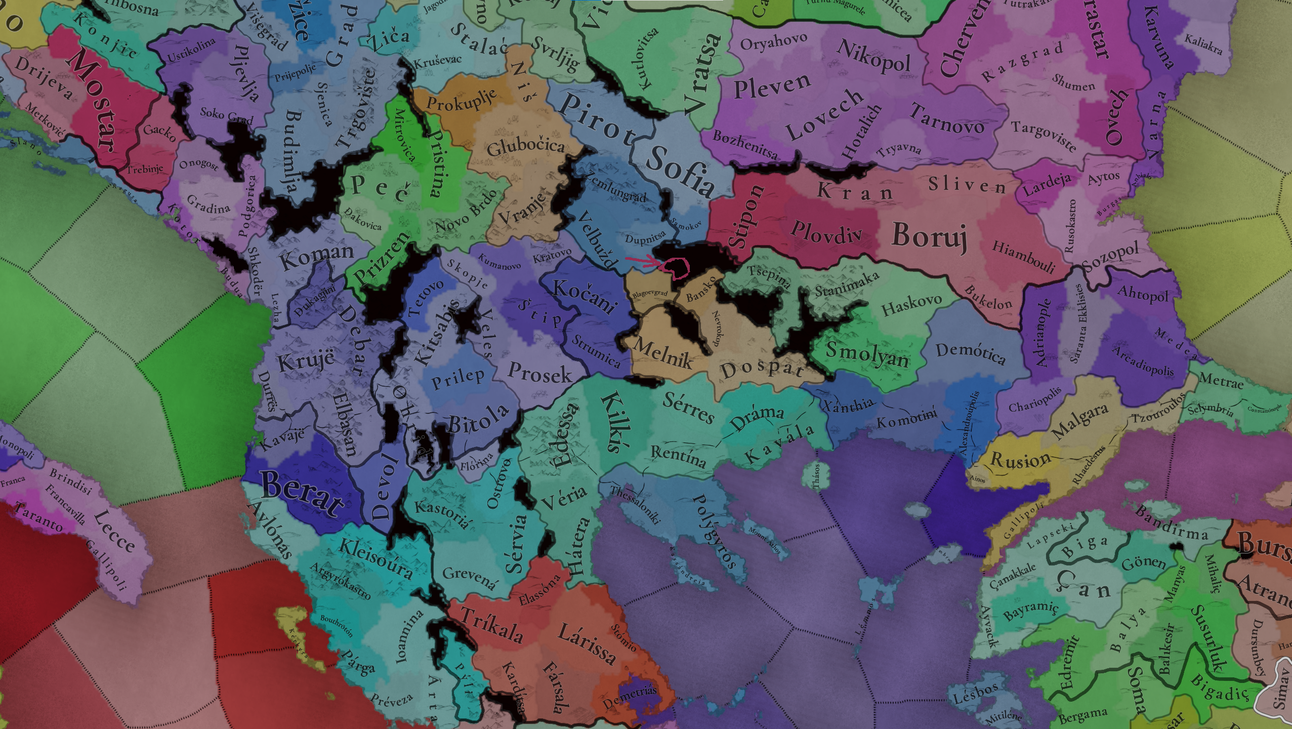
Locations 1.png

Locations 2.png

Locations 3.png

Locations 4.png
This week we’re posting the general map of the region, along with some more detailed maps, that can be seen if you click on the spoiler button. A starting comment is that the location density of Hungary is noticeably not very high; the reason is that it was one of the first European maps that we made, and we based it upon the historical counties. Therefore, I’m already saying in advance that this will be an area that we want to give more density when we do the review of the region; any help regarding that is welcome. Apart from that, you may notice on the more detailed maps that Crete appears in one, while not being present in the previous one; because of the zooming, the island will appear next week along with Cyprus, but I wanted to make an early sneak peek of the locations, given that is possible with this closer zoom level. Apart from that, I’m also saying in advance that we will make an important review of the Aegean Islands, so do not take them as a reference for anything, please.

Provinces:
Provinces.png

Provinces! Nothing outstanding to be commented on here; as usual, we’re open to any feedback regarding them.

Terrain:
Climate.png

Topography.png

Vegetation.png

Terrain! The climate of the region is mostly divided between Continental and Mediterranean, with some warmer and some colder regions. Regarding the topography, the Carpathian mountains are famously important and strategic, while the Balkans are a quite hilly and mountainous region, which is also greatly covered by woods and forests.

Cultures:
Cultures.png

Here comes the fun part of the DD: The cultural division of the Balkans! A few comments:
  1. Hungary is full of different minorities. Transylvania, especially, is an interesting place: there we have a mix of ‘Hungarians’, ‘Transylvanians’ (which are the Romanian-speaking inhabitants of the region), ‘Transylvanian Germans’, and ‘Szekely’ people.
  2. We have divided the Southern Slavic-speaking region into their dialectal families of Slovene, Croatian, Bosnian, and Serbian.
  3. The Southern Balkans are mostly divided among Bulgarian, Albanian, and Greek cultures.
  4. We’re also portraying plenty of other cultures, such as Dalmatians, Aromanians, Sclavenes, Arvanites, Cumans, Jasz, or Ashkenazi and Romanyoti Jews.

Religions:
Religion.png

This one is also interesting. Apart from the divide between Western Catholicism and Eastern Orthodoxy, we have the Krstjani in Bosnia, Bogomils (the pink stripes both in Bosnia and Macedonia), and Paulicians in Thrace. The Jewish populations do not pass the threshold percentage to appear on the map, but there are plenty of communities across the region.

Raw Materials:
Raw Materials.png

The materials of the region. Something very noticeable is the richness of minerals, with plenty of Iron, Copper, Tin, Lead, Gold, and Silver. Specifically, Slovakia is very rich, and you definitely want more settlers to migrate to the region, and exploit its resources. The region is also very rich in agricultural resources, as you can see.

Markets:
Markets.png

The region is mostly divided among four markets: Venice, Pest, Ragusa and Constantinople.

Country and Location population:
Population 1.png

Population 2.png

Population 3.png

Population 4.png
Country and location population (which I’ve also sub-divided, and is under the Spoiler button).

And that’s all of today! I hope that you find the region interesting; we certainly think that it is. Next week we will go further south, and we will take a look at the Syrian Levant and Egypt. Cheers!
 
  • 193Like
  • 69Love
  • 7
  • 4
  • 3
  • 1Haha
Reactions:
Was Moldavia really so "Wallachian" in 1337? The Moldavian chronicler Grigore Ureche (1590–1647) wrote that "the country consists of two languages, Romanian and Ruthenian, so he knows that even today it is a country of half Ruthenians and half of Romanians." (este tărsă den doao limbi, de rumâni și de ruși, de care lucur să nănăciu că și păn' ajţă este țărsă giumătate de ruși și giumătate de rumâni). The oldest Moldavian chronicles of the 15th century were written in the Old Slavic language. Many old toponyms in the northern and eastern parts of the Moldavian principality are of Slavic origin, for example Chernivtsi (Cernăuți) - from the Slavic word black (cherny/černý) or Khotyn (Hotin) - from the Slavic name Khotimir/Khotislav. According to various historians, in the 14th century, about 40-50% of the population of Moldova were Ruthenians.


Also what is the difference between Ruthenian and Rusyn cultures in 1337? The endonym Rusyn corresponds to the exonym Ruthenian. The English word Ruthenians is an exonym derived from the Latin Rutheni or Ruteni (singular Ruthenus), which also gave rise to the German Ruthenen and similar words in other languages. The first use of the word Ruteni in reference to the inhabitants of Rus was in the Augustian Annals in 1089. For centuries after that, the word Rutheni was used in Latin as the designation of all East Slavs, particularly Ukrainians and Belarusians.
 
  • 4
  • 2Like
  • 2
  • 1
Reactions:
Hi everyone!

I’m a bit late for this discussion but I saw these maps late and I needed some time to prepare this post. As a disclaimer I would like to state that I’m not historian and don’t pretend to be one. I just saw few things that I considered to be inconsistencies and started digging info to back my words. It appeared that the inconsistencies are a bit more than a few hence I ended up writing massive post (it’s a large topic after all). I would like to apologize if I repeat some statements, just couldn’t cover so many pages in this thread. My post mostly concern Bulgaria.
Unfortunately, it appeared that I can't post links due to low post count (that's my first post).


I. POLITICAL MAP
There are some inconsistences concerning Bulgaria in the political map mode. The Bukelon and Plovdiv (called Paldin [pəldin] back then) should not be part of Bulgaria at the starting date. Plovdiv was captured by the Byzantines in 1324 [1]. Then, the regent Anna of Savoy ceded Plovdiv along with eight fortresses (Tsepina, Krichim, Peristitsa, St. Ustina, Stanimaka, Aetos, Byaden and Koznik) back to Bulgarian tsar Ivan Alexander in 1344 as a reward for support against John VI Kantakouzenos during the civil war [2]. Regarding Bukelon, it was captured by Michael Shishman in 1328 but returned to the Byzantines shortly after [3].

Regarding the control of Višesav (correctly spelled as Višeslav or Visheslav), Kozelj, Svrljg, Pirot and Niš cannot be determined so straight forward. In order to determine which state controlled these locations (ate the starting date), the time frame should be rewinded back to the reigns of Shishman of Vidin and Stefan Uroš II Milutin. Serbia started expanding eastward in 1292 by defeating the Darman and Kudelin, capturing in the process Branicevo region along with the key fortresses Ždrelo (Zhdrelo) and Kucevo. Shishman supported by Nogai’s troops attacked Milutin in attempt to claim these territories or in revenge because of Darman and Kudelin fall (there are some assumptions that Shishman was relative to the brothers). Shishman’s campaign failed, which resulted in Milutin’s counter attack and capturing Vidin. This means that Visheslav, Kozelj and possibly Svrljg fell under Milutin’s control as well. However, according to Uzelac, 2011 [4] who cited archbishop Danilo II, the conflict was resolved through the mediation (intimidation) of Nogai. As a consequence, Milutin returned all of Shishman’s possessions, sent his son Stefan Dečanski to Nogai's court, while Shishman (recent widower) married the daughter of Serbian nobleman Dragoš. Moreover, Shishman married his son Michael Shishman (future Bulgarian emperor) to Milutin’s daughter Ana-Neda.

The next conflict between the two states was almost forty years later culminating at the Battle of Velbazhd in 1330. For the aftermath of the battle I’ll quote Fine, 1994 [5]: “Though the sources mention no territorial changes, many scholars believe the Serbs recovered Nis and its region at this time”. There was no other clashes between Bulgaria and Serbia until the starting date. If the sources are correct, we can assume that Višeslav, Kozelj, Svrljg and Pirot were part of Bulgaria at the starting date, while Niš is not so clear.


II. CULTURES

Looking at the demographic (culture) map seems too modern as well.
On another note, change the colors please. You may pick color for Bulgaria and Bulgarian culture similar to this in CK3 or EU4.
I’ll start with Belgrad and Braničevo regions. Their population should be predominantly Bulgarian at the starting date. Those regions were part of the First Bulgarian Empire for almost two centuries (829-1018). During most of this period new Bulgarian culture started to form. The conversion of Bulgaria to Orthodox Christianity (864/866), development of the Cyrillic alphabet and Old Church Slavonic, some cultural advances, along with military successes (especially during Simeon I reign) had a profound effect on the Slavs in the empire, who started associating themselves as Bulgarians. The above mentioned factors basically were the melting pot of the new Bulgarian identity during this period. I’m saying “New” because there were cultural differences to the Old Bulgar culture, even though the administrative apparatus and division didn’t changed at all. Evidence for catalyzed Bulgarian ethnicity we can find in the Bitola inscription (1015) where Ivan Vladislav claimed to be Bulgarian by birth (of Bulgarian kin). This formation of Bulgarian identity is also valid for the Belgrad and Braničevo regions. Belgrad was called in some sources (in Latin) as Alba Bulgarica. During the Byzantine rule (1018-1185(7)), indirect evidence for Bulgarian ethnicity in the Belgrad region was the uprising, led by Peter Delyan. It erupted in Belgrad in 1040 and spread southward to Thessaloniki. Later, during the restoration of the empire, Belgrad and Braničevo were captured relatively early on (1194-1195). Generally speaking, when you restore political entity you first aim to capture provinces/regions where the majority of the population is of your own culture in order to boost the manpower pool and economy (taxation). The Serbs was predominately concentrated in Duklja, Raška and Bosna regions until the middle of the 12th century. Their gradual expansion emerged due to power vacuum caused by disintegration of the Bulgarian Empire and weak Byzantine Empire in the second half of 13th century. They obtained Belgrad, Branicevo, Zdrelo and Kucevo very close to the starting date of the game. Belgrad’s first Serbian ruler was Stefan Dragutin who received it in 1284 as a Hungarian vassal. According to Fine, 1994 [6], Dragutin made an attempt, supported by Hungarian’s troops, to conquer Braničevo region from Darman and Kudelin in 1284 (or 1285) but he failed. The Hungarian support are the keywords here, which implies he didn’t have enough men (Serbian population) in Macva and Belgrad to stand up against the brothers. Later, as I already mentioned in the Introduction section, Braničevo got in Serbian possession in 1292. Although, 13th century was very turbulent (Belgrad and Braničevo changed hands many times between Bulgarian and Hungarians, and later Serbians), I couldn’t find any source claiming forced relocation of Bulgarians from Belgrad, Braničevo, Kucevo or Zdrelo regions. Serbian migration of large masses to such extent to negate Bulgarian majority in those regions is highly unlikely for so short period (1284/1292-1337) because (i) generally the Serbian population was not so large and (ii) these regions were frontier of the Serbian kingdom. Belgrad wasn’t even part of the Serbian kingdom until 1335. The ethnic composition of in-game Belgrad, Smederovo, Braničevo, Ravno, Stalac, Prokuplje and Novo Brdo locations should be mixed (Bulgarians and Serbians) but predominantly Bulgarian, while Kucevo, Kozelj, Svrljg, Nish, Pirot, Glubocica and Vranje should be solid Bulgarian at the starting date. The demography of Nish, Pirot, Glubocica (Leskovats), Vranje and eastern Kosovo was predominantly Bulgarian at least until 1848 according to Ami Boue's map (I can't post links. If you go to Ami Boue page in Wikipedia you will find the ethnographic map of the Balkans). Even the Serbians didn’t consider these four territories and eastern Kosovo to have significant Serbian population at least until the middle of 19th century. Two maps clearly show what the Serbians considered to be lands populated by Serbs – the first one was was created by Dimitrije Davidović in 1828 (If you go to Dimitrije Davidović page in Wikipedia you will find the map) and the second one was created by prof. Konstantin Desjardins in 1853.

Drastic demographic shift in Belgrad, Smederovo, Braničevo, Ravno, Stalac and Kucevo regions took place in the following centuries due to the Black Death, Ottoman conquest and Serbian migration. Moreover, Belgrade was one of the last bastions (enduring until 1521) of the Serbian medieval state resisting the Ottoman invasion. It is expected to have (naturally) some migration of Serbs from lands under Ottoman rule to territories under Serbian control during the whole 15th century.

The composition of Višeslav and Vidin must have been mixed (Bulgarian, Romanian and a bit of Cuman) at starting date. Generally, the ethnic composition immediately next to the both banks of Danube (from Višeslav/Severin to Tulcea/Chilia) was mixed, whereas northern side was predominantly Romanian, while southern Bulgarian. Harsova and Tulcea should be predominantly Bulgarian not another way around.

Significant Albanian and Serbian presence in the in-game Prilep and Vardar provinces is exaggerated for this time period as well, imo. Significant Albanian migration toward western Macedonia and Kosovo took place during the Ottoman Period. I was also surprised to see Albanian presence in Kran location. Regarding Serbian presence in Macedonia, check the maps above (Ami Boue's and Dimitrije Davidović's).

Are there any traces of Cuman culture? There should be some traces in Southern Wallachia, Northern Bulgaria, Kucevo, Visheslav,


References
[1] - "Historia by John Kantakouzenos" in GIBI, vol. X, Bulgarian Academy of Sciences, Sofia, p. 227
[2] - Fine, The Late Medieval Balkans: A Critical Survey from the Late Twelfth Century to the Ottoman Conquest, p. 304.
[3] - Cantacuzenus, vol I, p. 326;
[4] – Uzelac, 2011,Tatars And Serbs At The End Of The Thirteenth Century, p. 14.
[5] - Fine, The Late Medieval Balkans: A Critical Survey from the Late Twelfth Century to the Ottoman Conquest, p. 272.
[6] - Fine, The Late Medieval Balkans: A Critical Survey from the Late Twelfth Century to the Ottoman Conquest, p. 220.
 
Last edited:
  • 5Like
  • 5
  • 2
  • 2
Reactions:

III. PROVINCES AND LOCATIONS (Part 1)​

First I want to address dynamic names of the locations and provinces. It should be considered the contemporary system (since 2009) for transliteration from Bulgarian Cyrillic into the Latin alphabet for the names when the player play Bulgaria or in-game controlled locations and provinces by Bulgaria. This system was adopted by law and used by the Bulgarian authorities. Sounds like [ʃ], [tʃ], [ts], [ʒ] and [ə] are transliterated by sh, ch, ts, zh and a, respectively.

The borders of the provinces and locations look too modern imho. There are some evident anachronisms, most blatant being Blagoevgrad (Gorna Dzhumaya was renamed Blagoevgrad after Dimitar Blagoev in 1950).

Now, I will focus on the administrative division and try to shed light on the provinces from medieval Bulgarian perspective. I’d like to share here the Dubrovnik Charter (Link) even though it was issued in 1230, about 100 years before the starting date. At this point the Second Bulgarian Empire had its largest territorial extension. This charter provides precious information about the state administrative centers even though not depicting exact borders of the provinces. A single province was called hora (hori plural), a term directly borrowed from Byzantine administrative apparatus (in Greek hora means land). The charter gave exclusive trade rights to the Dubrovnik merchants. Unfortunately, I was not able to find official translation in English, so I’ll post here raw machine translation from modern Bulgarian (LINK) to English:

“My empire gives this order to the Dubrovnik country, to the beloved and faithful guests of my empire, to go throughout the country of my empire with any goods, to import or export, or to carry any goods, and to which and whether it is a land or a region [hora/province] to come: do they come to Bdin or Branicevo and Belgrade, or go to Tarnovo and all of Zagore, or reach Preslav and the Karvuna region, or the Kran region, or the Boruy region, or Edirne and Dimotika, or in the region of Skopje, or in the region of Prilep, or in the region of Devol, or in the land of Arban [Albania], or they go to Thessalonica - everywhere to buy and sell freely, without any damage, not to be prohibited in all the regions of my empire and buy and sell without care as all-faithful and beloved guests of my empire. Whoever harms them in any way in the gorges, in the marketplaces, or wherever it is against the law of trade, let it be known that he is an adversary of my empire, and there will be no mercy, but great wrath will he suffer from my empire.”

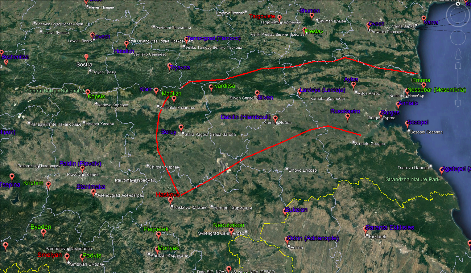
First, it should be clarified which region/province was called Zagore in the document. At this point of history Zagore was called the region around Tarnovo. In some cases the whole Bulgaria was called Zagora evident in some Venetian documents. The in-game Zagore (consisting Stipon, Plovdiv, Kran, Boruj, Sliven, Bukelon, Hiambouli) is not completely incorrect but the province name was from another time (during the First Bulgarian Empire). Tervel (700-721) was the first Bulgarian ruler to acquire this region in 705. The province (back then) stretched from Boruy to Black sea and from Erkesiya wall to Balkan Mountain (red curves in Fig. 1), which means that Plovdiv, Stipon and possibly Kran were not part of it. For some reason the toponym migrated northward to Tarnovo in the later centuries, which is not so unusual (check Roman/Byzantine province/thema Macedonia over the centuries).

It is also notable to point out that Sredets (Sofia), Nish and Plovdiv (Paldin) provinces were not mentioned for some reason in the document. There is no doubt that these provinces were part of the state in 1230. Maybe the administration forgot to include them in the charter or they were part of another provinces (hori).

1-Old Zagore.png

Fig. 1. Borders of the region Zagore during the First Bulgarian Empire


Now I’ll go through the in-game provinces and locations concerning Bulgaria in one way or another. I’ll provide some explanation why some provinces/locations should be restructured or renamed or completely removed (partitioned) or included.

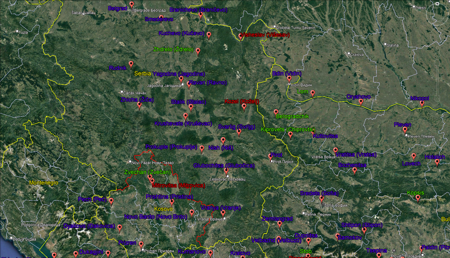
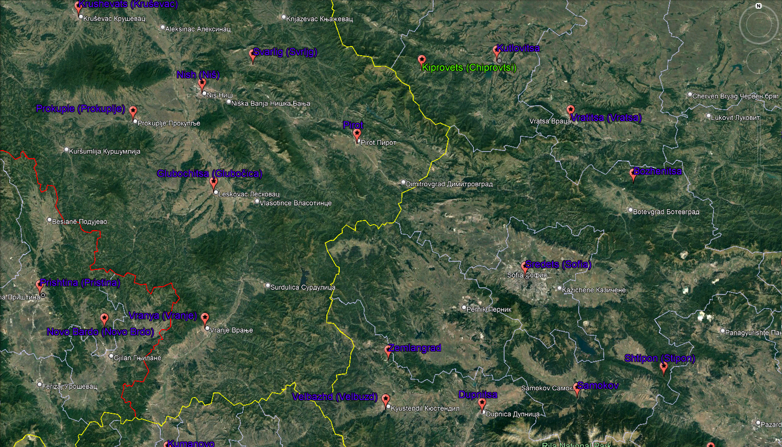
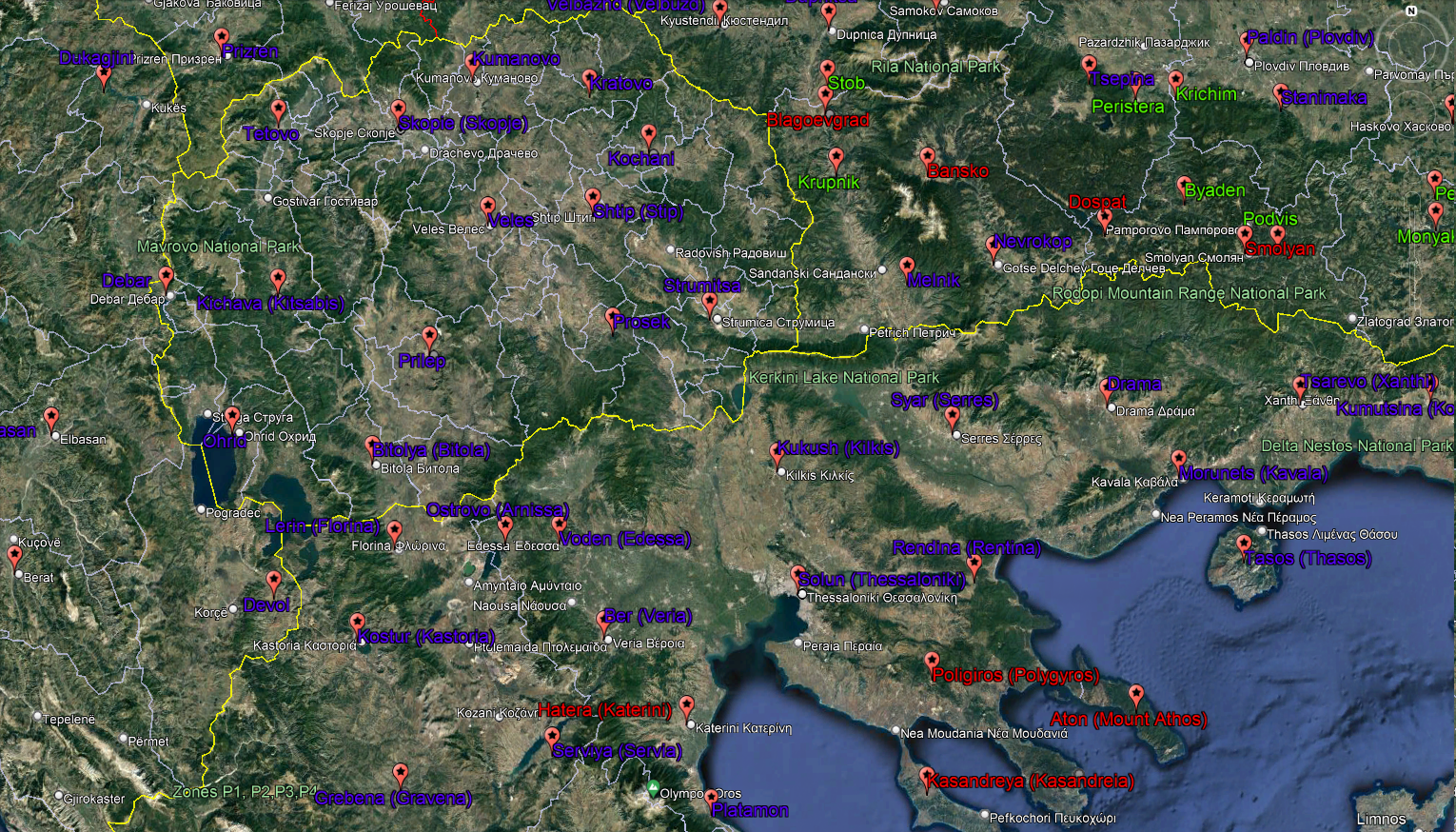
The exact locations of cities, towns and fortresses were marked on the maps below. The blue labels are the in-game places I consider should make in the final game, while the red should be removed/renamed/replaced/partitioned. The new proposals were labeled in green. The yellow labels means not sure whether should go or not or be included. The yellow and white curves are the modern borders of the countries and provinces, respectively, while the white labels are the modern names of cities and towns.

Here is how the names of the provinces and locations are ordered:
Current in-game names on the map -> Romanized names in Bulgarian [transcription]

First group of provinces is:

ŠUMADIJA, BRANIČEVO, TOPLICA and KOSOVO provinces

Šumadija and Braničevo look like too small provinces, only three locations each.
Šumadija province may be named Belgrad when the player play Bulgaria.
Ždrelo (Zhdrelo) was important fortress and it should be added as a new location in Braničevo province imo. It may be formed by taking territories from Braničevo, Kucevo and Ravno.
Mitrovica should be renamed to Zvečan, which was more significant place at this point of history and it was very close to Mitrovica.

2-Belgrad-Bran-Top-Kos.png

Fig. 2. The exact locations of current in-game and newly-proposed cities, towns and fortresses in the Šumadija, Braničevo, Toplica and Kosovo provinces


Province Šumadija -> Shumadiya [ʃumadija] or Belgrad [belgrad]
Belgrad -> Belgrad [belgrad]
Smederovo -> Smederovo [smederovo]
Rudnik -> Rudnik [rudnik]

Province Braničevo -> Branichevo [branitʃevo]
Braničevo -> Branichevo [branitʃevo]
Kučevo -> Kuchevo [kutʃevo]
Ravno -> Ravan [ravən]
Ždrelo -> Zhdrelo [ʒdrelo] – new proposal

Province Toplica -> Toplitsa [toplitsa]
Žiča -> Zhicha [ʒitʃa]
Jagodina -> Yagodina [jagodina]
Stalać -> Stalik [stalik]
Kruševac -> Krushevats [kruʃevats]

Province Kosovo -> Kosovo [kosovo]
Zvečan -> Zvechan [zvetʃan] – new proposal, renamed Mitrovica
Pristina -> Prishtina [priʃtina]
Peč -> Pech [petʃ]
Đakovica -> Dyakovo [djakovo]
Prizren -> Prizren [prizren]
Novo Brdo -> Novo Bardo [novo bərdo]

NISH and SHOPLUK provinces

Province Shopluk should be renamed to Sredets [sredets] (BG Cyrillic: Средец) if you want to go historical. Shopluk is a vague ethnographic region, not a province.
Sofia also should be renamed to Sredets [sredets] (BG Cyrillic: Средец).
Shtipon (Stipon aka Stenos) should be part of this province. Historically, Shtipon was the first defense line of Sredets against the coming armies from Plovdiv (Philipopolis). This location should not have so large sphere of control. Basically, Shtipon controlled only the pass, the valley around nowadays Ihtiman and possibly Kostenets valley. The northern part of this location should be added to the newly-proposed Kopsis location but about this later.

3-Nish-Sredets.png

Fig. 3. The exact locations of current in-game and newly-proposed cities, towns and fortresses in the Nish and Sredets provinces


Here are the systemized provinces with locations:
Province Niš -> Nish [niʃ]
Niš -> Nish [niʃ]
Prokuplje -> Prokuple [prokuple]
Glubočica -> Glubochitsa [gubotʃitsa]
Vranje -> Vranya [Vranja]

Province Shopluk -> Sredets [sredets]
Sofia –> Sredets [sredets]
Pirot -> Pirot [pirot]
Zemlungrad -> Zemlangrad [zemləngrad]
Velbuzd -> Velbazhd [velbəʒd]
Dupnitsa -> Dupnitsa [dupnitsa] sometimes referred in some sources as Tobinitsa/Doupla/Dabnitsa [tobinitsa/doupla/dəbnitsa]
Samokov -> Samokov [samokov]
Stipon -> Shtipon [ʃtipon] – transferred from in-game Zagore

PRILEP, VARDAR, PIRIN, CHALKIDIKI, UPPER MACEDONIA and LOWER MACEDONIA provinces

If we follow the Dubrovnik charter the whole Macedonian region should be divided in four provinces but first I’ll point out the anachronisms – Blagoevgrad, Bansko and Dospat. I explained already about Blagoevgrad. There was no significant settlement at the same place at this point of history. Candidates for replacement are Stob or Krupnik, Stob being the better candidate for this period.
There was Thracian fortress nearby Bansko but it was abandoned ca. late antiquity. There is not proper candidate for this time period. Bansko territory should be partitioned between Stob/Krupnik and Nevrokop.

EDIT after discussion with Antimonum: Dospat is the same story as Bansko. The location should be split between Nevrokop and neighboring locations in Rhodopes province. Moreover, the contemporary. The Dospat is located deep in the Rhodope Mountains and should be transferred in Rodopes province.

Nevrokop (aka Nikopolis) location should be moved to the Rhodopes province imo. Mesta River divides Pirin Mountain and Rhodope Mountain as Nevrokop is almost in the middle, slightly on the Pirin side. However, there were few fortresses like “Gradishte St. Archangel Michael” and “St. Dimitar” (we don’t know their medieval names), which were on Rhodope side and they were in Nevrokop sphere of control. Gameplay wise it is better to be in Rhodopes imo.

The Chalkidiki province seems a bit off. Thessaloniki (Solun) was a big city (second largest in the Byzantine Empire only after Constantinople), a port and significant trade hub. Imo, it should be administrative center of much larger province. I think some location merging is needed here. Thessaloniki and Kasandreia should be merged in Thessaloniki location, while the merging of Rentina, Mount Athos and Polygyros should result in formation of Rentina location.

The name of the Hatera location should be renamed to Platamon. Platamon was more significant place than Hatera.

Historically, Debar and Devol were considered part of the Macedonian region hence they should be excluded from Albania and transferred to the neighboring Macedonian provinces.

My proposal for the whole Macedonian region is to be reorganized in the four historic provinces: Devol, Skopje, Prilep and Thessaloniki (Solun) instead inventing new ones like Pirin, Chalkidiki etc.

4-Macedonia.png

Fig. 4. The exact locations of current in-game and newly-proposed cities, towns and fortresses in the new Devol, Skopie, Prilep and Thessaloniki provinces


Here are the provinces and locatiosn:
Province Devol -> Devol [devol]
Ohrid -> Ohrid [ohrid]
Devol -> Devol [devol] – transferred from Albania
Kastoria -> Kostur [kostur]
Gravena -> Grebena [grebena]
Servia -> Serviya [servija]
Ostrovo -> Ostrovo [ostrovo]
Florina -> Lerin [lerin]
Debar -> Debar [debər] – transferred from Albania

Province Skopje -> Skopie [skopie]
Skopje -> Skopie [skopie]
Kumanovo -> Kumanovo [kumanovo]
Kratovo -> Kratovo [kratovo]
Stip -> Shtip [ʃtip]
Kocani -> Kochani [kotʃani]
Stob [stob] or Krupnik [krupnik] – new proposals, renamed Blagoevgrad
Strumica -> Strumitsa [strumitsa]
Melnik -> Melnik [melnik]

Province Prilep -> Prilep [prilep]
Tetovo -> Tetovo [tetovo]
Kitsabis -> Kichava [kitʃava]
Veles -> Veles [veles]
Prilep -> Prilep [prilep]
Bitola -> Bitolya [bitolja]
Prosek -> Prosek [prosek]
Edessa -> Voden [voden]

Province Thessaloniki -> Solun [solun]
Platamon -> Platamon [platamon] – new proposal, renamed Hatera (Katerini)
Veria -> Ber [ber]
Thessaloniki -> Solun [solun]
Kilkis -> Kukush [kukuʃ]
Rentina -> Rendina [rendina]
Serres -> Syar [sjar]
Drama -> Drama [drama]
Kavala -> Morunets [morunets]
Thasos -> Tasos [tasos]

EDIT:
I reconsidered the Dospat situation after a discussion with Antimonum (below) and I decided to include it in Rodopes province
 
Last edited:
  • 8
  • 3
  • 2
  • 1Like
Reactions:

III. PROVINCES AND LOCATIONS (Part 2)​

RHODOPE, ZAGORE, BURGAS, EVROS AND EDIRNE provinces

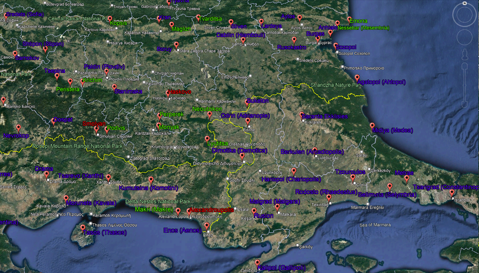
The locations’ borders in Rhodopes province should be completely redrawn (imo) due to anachronisms like Smolyan and Haskovo. There were much more important places in the Rhodope Mountain during this period like Podvis , Perperek (aka Perperikon), Monyak (Mneakos), Lyutitsa (seat of bishop), Neutzikon, Byaden [2] etc (Fig. 5). Imho, Rhodope province should be redrawn as follows: Tsepina and Nevrokop should be north-western and south-western locations, respectively, Dospat, Podvis and Perperek/Monyak in the middle, while Neutzikon and Lyutitsa north-eastern and south-eastern parts, respectively. Perperek and Monyak were very close to each other so one the two should be chosen.

Stanimaka fortress was on the very “edge” (north mountain foot) of Rhodope Mountains and gravitated more toward Plovdiv, hence it’s a part of newly-proposed Plovdiv (Paldin) province. Plovdiv deserve to be an administrative center of a province due to its strategic and economic significance. Here are the new proposals for locations in this new province: Krichim [2] , Peristera and Kopsis. Krichim and Peristera were on the edge of Rhodope similarly to Stanimaka. Those two locations should be small in size similar to the in-game Burgas or Anhialo. Kopsis might be formed from western part of Kran and already mentioned northern part of Shtipon.

The leftovers from Zagore are in the newly-proposed Boruy province now. Bukelon should be transferred to Odrin (Edirne) province because it makes more sense to be part of this province. It’s never been a part of the old Zagore (8-11 century) or Boruy hora. The new proposals for Boruy province are: Maglizh and Tvarditsa. Both fortresses controlled the southern part of the Trevnenski and Elena-Tvarditsa passes, respectively, in Balkan Mountain. Among the two, Tvarditsa was the more significant place, which evolved to fortress-town (12-14 century). Lardeja is also included to the Buruy province due to its location being deep inland.

New proposals for Burgas province are: Nesebar (Mesembria) and Emona. Nesebar was important trade center, while Emona had more strategic/defense purpose. Both provinces could be formed by taking land form southern part of Varna and northern part of Anhialo. Anhialo should incorporate some land from neighboring Aytos. Burgas also should be slightly bigger, it should be on both sides of the bay.

Evros province should be named Dimotika when the player play Bulgaria. Alexandroupolis is an anachronism comparable to Blagoevgrad. The site was settled in 19th century as a small fishing village called Dedeagach (part of the Ottoman Empire back then). After the WW1 the Greeks renamed it to Alexandroupoli. My proposal is the name to be changed to Makri for this location.

Saranta Ekklisies is called Lozengrad in Bulgarian nowadays. However, the first appearance of the name Lozengrad was in 17th century. So, I’ll leave it as Saranta Ekklisies.

5-PL_Rh_BU_OD_DIM.png

Fig. 5. The exact locations of current in-game and newly-proposed cities, towns and fortresses in the Paldin, Rhodopes, Boruy, Burgas, Dimotika and Odrin provinces


Here are the provinces and location:
Province Plovdiv -> Paldin [pəldin]
Kran -> Kran [krən]
Kopsis [kopsis] – new proposal
Peristera [peristera] – new proposal
Krichim [kritʃim] – new proposal
Plovdiv -> Paldin [pəldin]
Stanimaka -> Stanimaka [stanimaka]

Province Rhodopes -> Rodopi [rodopi]
Tsepina -> Tsepina [tsepina]
Nevrokop -> Nevrokop [nevrokop] – transferred from Pirin
Dospat -> Dospat [dospat]
Podvis [podvis] – new proposal
Perperek [perperek] or Monyak [monjak] – new proposal
Lyutitsa [ljutitsa] (BG Cyrillic: Лютица) – new proposal
Neoutzikon -> Neutzikon [neut zikon] – new proposal

Province Boruj -> Boruy [boruj]
Boruj -> Boruy [boruj]
Maglizh [məgliʒ] – new proposal
Tvarditsa [tvərditsa] – new proposal
Sliven -> Sliven [sliven]
Hiambouli -> Dabilin [dəbilin]
Lardeja -> Lardeya [lardeja] – transferred from Burgas

Province Burgas -> Burgas [burgas]
Aytos -> Aytos [ajtos]
Rusokastro -> Rusokastro [rusokastro]
Burgas -> Burgas [burgas]
Sozopol -> Sozopol [sozopol]
Anhialo -> Anhialo [anhialo]
Nesebar [nesebər] – new proposal (aka Mesembria)
Emona [emona] – new proposal

Province Evros -> Dimotika [dimotika]
Demotica -> Dimotika [dimotika]
Xanthi -> Tsarevo [tsarevo]
Komotini -> Kumutsina [kumutsina]
Makri [makri] – new proposal, renamed Alexandroupolis

Province Edirne -> Odrin [odrin]
Chariopolis -> Hariopol [hariopol]
Adrianople -> Odrin [odrin]
Bukelon -> Bukelon [bukelon]
Saranta Ekklisies -> Saranta Ekklisies
Ahtopol -> Agatopol [agatopol]
Medea -> Midiya [midija]
Arcadiopolis -> Berkulen [berkulen]

EDIT:
I reconsidered the Dospat situation after a discussion with Antimonum (below) and I decided to include it in Rodopes province
 
Last edited:
  • 5
  • 4
  • 2
Reactions:

III. PROVINCES AND LOCATIONS (Part 3)​

DOBRUJA (DOBRUDZHA) and SILISTRA provinces

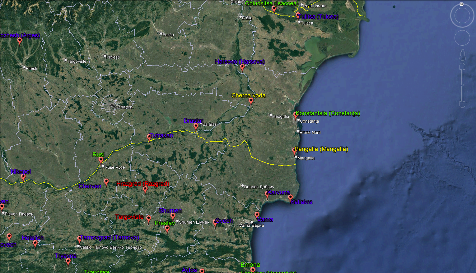
If we follow the Dubrovnik charter Dobruja (Dobrudzha) province should be called Karvuna. But Dobruja is just fine as well.
Varna stretches too much southward imo. It should not cross over the ridge of Balkan Mountain. The ridge of Balkan Mountain was and is used as a natural/administrative border between provinces. I guess the the Despotate of Dobruja was mirrored into the in-game Dobruja province. However, this is not correct and places like Nesebar (Mesembria) and Emona should be part of Burgas (Pyrgos) province.
Constanța (Konstantsiya) is much more significant place in comparison to Pangalia (Mangalia).
Another proposal for location in this province is Obluchitsa (Isaccea).

The province name Silistra is anachronism. It is just the modern name of Drastar.
Initially, Preslav was administrative center of the in-game Silistra province in the Second Bulgarian Empire but Shumen overshadowed it economically and militarily after the Mongol invasions sometime in the second half of 13th century. So, Shumen is better candidate for administrative center and name of this province.
The records about Razgrad are scarce. It was mentioned in some sources as Hrasgrad [hrəsgrad] but the archaeologists can’t agree which archaeological site was the mediaeval Hrasgrad, even whether the location was even near the modern Razgrad. It was not so significant settlement at this point of history, so it should be removed. Targoviste is the same story, it was not significant settlement at start of the game. The territories of Razgrad and Targoviste should be divided between Shumen and the newly-proposed Preslav. Preslav was plundered by the Tatars but revived to some extent even though never reaching the former significance again.
Another new proposal is Rusi, nowadays called Ruse. It was fortress/trade center on the Danube River. It is also known as Pirgovo or Golyamo Yorgovo (meaning Big/Large Yorgovo)

6-Dobruja&Drastar.png

Fig. 6. The exact locations of current in-game and newly-proposed cities, towns and fortresses in Dobruja (Dobrudzha) and Shumen/Preslav provinces

Here are the structured provinces with locations:
Province Dobruja -> Dobrudzha [dobrudʒa] or Karvuna -> Karvuna [karvuna]
Varna -> Varna [varna]
Karvuna -> Karvuna [karvuna]
Kaliakra -> Kaliakra [kaliakra]
Hârșova -> Harsovo [hərsovo]
Tulcea -> Tulitsa [tulitsa]
Obluchitsa [oblutʃitsa] – new proposal
Constanța -> Konstantsiya [konstantsija] – new proposal, renamed Pangalia

Shumen -> Shumen [ʃumen] or Province Preslav -> Preslav [preslav]
Drastar -> Drastar [drəstər]
Ovech -> Ovech [ovetʃ]
Cherven -> Cherven [tʃerven]
Tutrakan -> Tutrakan [tutrakan]
Shumen -> Shumen [ʃumen]
Preslav -> Preslav [preslav] – new proposal
Rusi -> Rusi [rusi] – new proposal

TARNOVO and VIDIN (BDIN) provinces

I already mentioned about the migration of the toponym Zagore. However, I think the province should be called Tarnovo, otherwise it may cause some confusion in the Bulgarian players. Many people (including me) don’t (didn’t) know about the fact that the region around Tarnovo was called Zagore during the Second Bulgarian Empire. Anyway, don’t name Zagore the Boruy region either because is not accurate for this time frame.

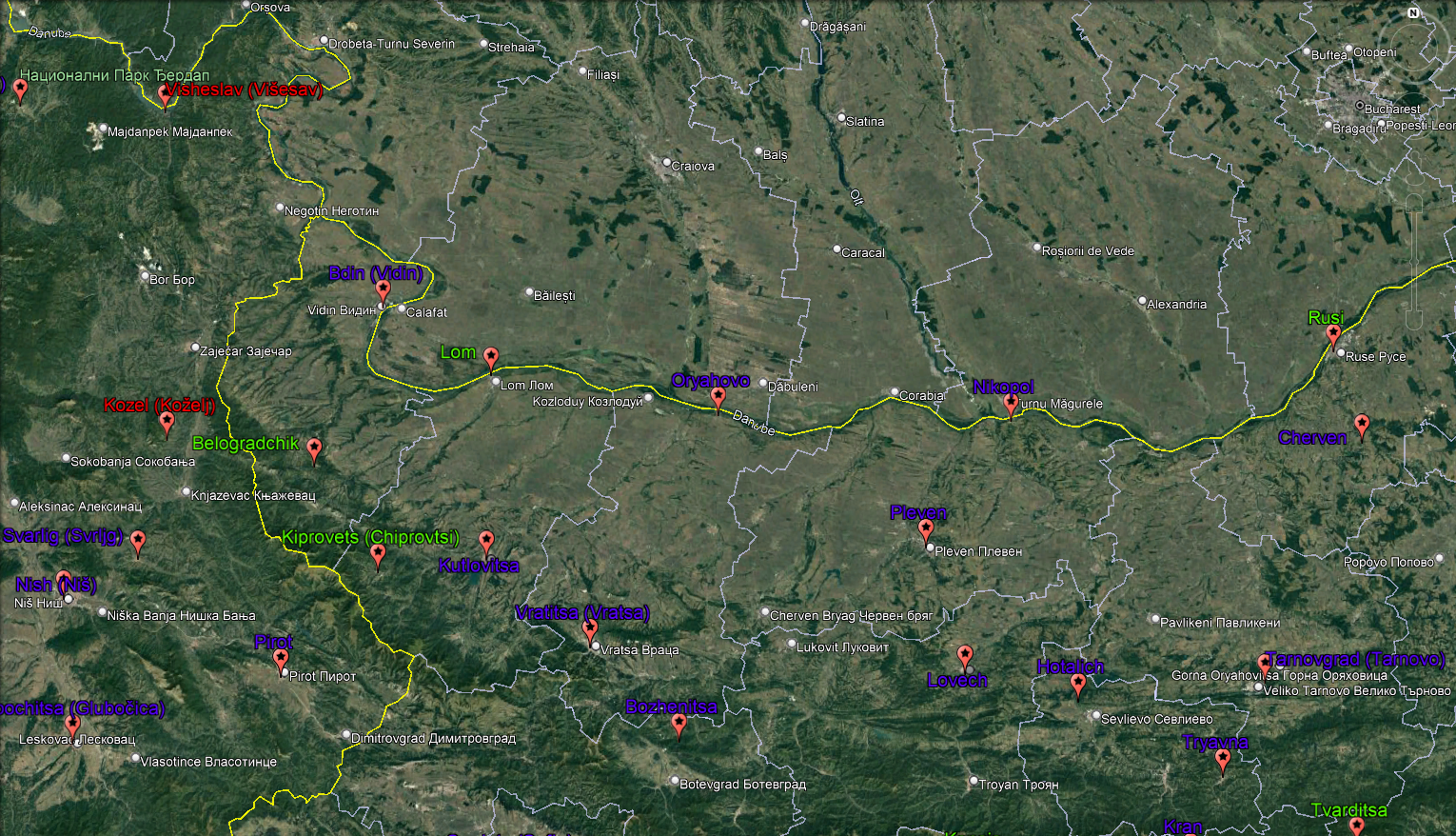
I believe the Višesav location is misspelled . It should be Višeslav or Visheslav (Romanized Bulgarian). Strangely, I could not find any information about Višeslav and Kozelj besides few maps. Those locations/regions were densely-forested and low populated back then therefore they were not so significant and should be divided by the surrounding locations, imo. Višesav should be added to Vidin, while Kozelj should be portioned between Svrljg and the newly-proposed Belogradchik.
The sphere of control of Vratsa (Vratitsa) and Kutlovitsa should not reach the Danube River. Their purpose was to control the Balkan Mountain passes the same way like Bozhenitsa. Vratitsa (meaning door/gate) and Kutlovitsa northern parts should be added to the newly-proposed Lom location. Generally the fortresses, which controlled the mountain passes had limited sphere of control hence these two should be comparable to Samokov, Burgas or Anhialo in size for instance.

Lom, Belogradchik and Kiprovets are the new proposals.
Lom was small fortress on the southern shore of the Danube. Older (antiquity) name of the fortress was Almus.
Belogradchik started growing in significance around the starting date, marking a peak during the reign of Ivan Stratsimir. The location might be formed by taking land from southern Vidin and possibly part of Kozelj.
Kiprovets (nowadays Chiprovtsi) was not fortified place but it was important mining center. Saxon miners came to Kiprovets to help improving the extraction technology. Although small in numbers (50-60) these Saxons had a deep impact on the locals which converted to Roman Catholicism. Later the town had a special status in the Ottoman Empire due to its silver, lead and gold deposits. Silver should be the in-game raw material as the silver was the most mined material. The location might be formed from the south-western part of Kutlovitsa.


7-Tarnovo&Bdin.png

Fig. 7. The exact locations of current in-game and newly-proposed cities, towns and fortresses in Tarnovo and Bdin provinces

Here are the structured provinces with locations:
Province Tarnovo -> Tarnovo [tərnovo]
Tarnovo -> Tarnovgrad [tərnovgrad]
Tryavna-> Tryavna [trjavna]
Hotalich -> Hotalich [hotalitʃ]
Nikopol -> Nikopol [nikopol]
Pleven -> Pleven [pleven]
Lovech -> Lovech [lovetʃ]
Bozhenitsa-> Bozhenitsa [boʒenitsa]
Oryahovo -> Oryahovo [orjahovo]

Province Vidin -> Bdin [bdin]
Vidin -> Bdin [bdin]
Vratsa -> Vratitsa [vratitsa]
Kutlovitsa -> Kutlovitsa [kutlovitsa]
Svrljg -> Svarlig [svərlig]
Belogradchik [belogradtʃik] – new proposal
Kiprovets [kiprovets] – new proposal
Lom [lom] – new proposal

Additional places differently transliterated or called in Bulgarian

Province Byzantion -> Tsarigrad [tsarigrad]
Constantinople -> Tsarigrad [tsarigrad]
Selymbria -> Selimvriya [selimvriya]

Province Dardanelles -> Dardaneli [darnaneli]
Ainos -> Enos [enos]
Malgara -> Malgrad [malgrad]
Gallipoli -> Kalipol [kalipol]
Rhaedestus -> Rodosto [rodosto]

Province Illyria -> Iliriya [ilirija]
Shkodër -> Shkodra [ʃkodra]

Province Albania -> Albania [albania]
Avlonas should be included in Albania imo.
Avlonas -> Vlyora [vljora]
Krujë -> Kruya [kruja]
Durrës -> Drach [dratʃ]
Kavajë -> Kavaya [kavaja]
Berat -> Beligrad [beligrad]

Province Epirus -> Epir [epir]
Ioannina -> Yoanina [joanina]
Bouthroton -> Butrint [butrint]
Kleisoura -> Klisura [klisura]

Some locations in Wallachia. Wallachia is called Vlashko [vlaʃko] in Bulgarian.
Orsova -> Orsovo [orsovo]
Turnu Măgurele -> Holavnik [holavnik]
Giurgiu -> Malko Yorgovo [malko jorgovo]
Zimnicea -> Zimnich [zimnitʃ]
Argeș -> Kurtya de Ardzhesh [kurtja de ardʒeʃ]
Galați -> Galats [galats]
 
Last edited:
  • 10
  • 2
  • 2
Reactions:
There are some inconsistences concerning Bulgaria in the political map mode. The Bukelon and Plovdiv (called Paldin [pəldin] back then) should not be part of Bulgaria at the starting date. Plovdiv was captured by the Byzantines in 1324 [1]. Then, the regent Anna of Savoy ceded Plovdiv along with eight fortresses (Tsepina, Krichim, Peristitsa, St. Ustina, Stanimaka, Aetos, Byaden and Koznik) back to Bulgarian tsar Ivan Alexander in 1344 as a reward for support against John VI Kantakouzenos during the civil war [
Technically correct although if Plovdiv location gets transferred to Byz as is, then the Border would be incorrect. Plovdiv today is on both sides of Maritsa river (mostly to the south) and it used to only be located south of Maritsa. The border logically can only be situated on Maritsa River in 1337. The Plovdiv location in game seems to mostly be to the north of Maritsa. Stanimaka has most of the Land south of Maritsa as of now. If the location is to be transferred to Byz, then Plovdiv location should be shifted to the south, which leaves no place for Stanimaka (probably would not have 100 pixels if done correctly). About the Name Paldin, both Plovdiv and Paldin are corruptions of Pulpudeva and probably all get used. Alternativ pronunciation was also Plavdiv.

An other note I have is Lozengrad. Even if first appearing in sources in 17th century, this does not mean it had a different name before. A lot of terms and names in Bulgarian get mentioned for the first time by Ottoman Census sources or in the 17th 18th and 19th century, when Bulgarian sources (other then royal officials and clergy from the middle ages) began writing down terms and Names. Those appeared not out of the vacuum though.

Alsoe about Dospat. The name is not anachronistic, since it is probably a corruption of the word Despot. The main theory is that Dospat is named after Despot Aleksi Slav, who used to rule there in 1207-1230. The name first appears in an Ottoman census but the same as Lozengrad, we do not have Bulgarian written sources referring the Name before that. The location may be deep in the Rhodope mountain but had a River Valley which almost certainly means that it was settled with at least villages. I would add Dospat to Rhodope Province.

I would also would give the province of Silistra the name Drastar, since Shumen was not as important as Drastar with the Danube Port and Preslav lost most of its significance at the turn of the Millennium.

I would lastly not add Struma valley to Skopje Province - it is too far away and isolated. I would keep Pirin as a Province (without Dospat and Nevrokop, who should be in Rhodope) and call the Province Melnik instead (an important city at the time). I would add Stob to Melnik Province and also Rila as a Monastery location in the Vicinity of Stob.

Other than that cheers for the work - a lot of stellar suggestions.
 
Last edited:
  • 5
  • 2Like
  • 2
Reactions:
Technically correct although if Plovdiv location gets transferred to Byz as is, then the Border would be incorrect. Plovdiv today is on both sides of Maritsa river (mostly to the south) and it used to only be located south of Maritsa. The border logically can only be situated on Maritsa River in 1337. The Plovdiv location in game seems to mostly be to the north of Maritsa. Stanimaka has most of the Land south of Maritsa as of now. If the location is to be transferred to Byz, then Plovdiv location should be shifted to the south, which leaves no place for Stanimaka (probably would not have 100 pixels if done correctly). About the Name Paldin, both Plovdiv and Paldin are corruptions of Pulpudeva and probably all get used. Alternativ pronunciation was also Plavdiv.

You might be right. Now, when I look closely, the border between Bulgaria and Byzantium seems to resemble the curve of Maritsa. You are right that most of Plovdiv location should be part of Bulgaria at this point besides the city itself. I hope the major rivers will be presented in the final game.


Alsoe about Dospat. The name is not anachronistic, since it is probably a corruption of the word Despot. The main theory is that Dospat is named after Despot Aleksi Slav, who used to rule there in 1207-1230. The name first appears in an Ottoman census but the same as Lozengrad, we do not have Bulgarian written sources referring the Name before that. The location may be deep in the Rhodope mountain but had a River Valley which almost certainly means that it was settled with at least villages. I would add Dospat to Rhodope Province.

I know about the name theory. Still, we can’t be sure if the name was around the starting date or not. However, when you brought the subject on, I checked again and it appeared that I have completely overlooked that there was an important fortress nearby Dospat from this period (12-14th century) called Hisarya or Hisarlaka nowadays. The fortress was on crossroad connecting Rhodopes, Macedonia and Aegean coast. Unfortunately, most of the fortress remains were blast during the construction “Dospat” dam wall. Only the foundation of the eastern wall is still around. I guess, we can live with Dospat name (and a little doubt about it :) ) after we have archeological proof for an important settlement.


I would lastly not add Struma valley to Skopje Province - it is too far away and isolated. I would keep Pirin as a Province (without Dospat and Nevrokop, who should be in Rhodope) and call the Province Melnik instead (an important city at the time). I would add Stob to Melnik Province and also Rila as a Monastery location in the Vicinity of Stob.

Perhaps you are right but Skopie was a capital of much larger region (Bulgaria theme) in 11-12 centuries. We can even speculate that Velbazhd, Sredets and Nish were part of the Skopie province (Skopska hora) during the reign of Ivan Asen II, considering that those cities (especially Sredets and Nish) were not mentioned in Dubrovnik charter. Melnik is another story, of course, mostly because it was part of Aleksi Slav’s domain during Ivan Asen II rule. It is really hard to determine the provinces at the starting date because the region was fragmented mostly between Serbia and Byzantines but also nominally dependent feudal lords.

I was wandering why Dospat is in this so-called Pirin province. After this discussion, I started to realize that maybe the devs tried to mirror Aleksi Slav’s domain into in-game Pirin with one major exception… Tsepina. Tsepina was Aleksi Slav’s capital until 1211(2) when Melnik replaced it.

I also considered Rila Monastery at some point but it dropped out from my suggestions mostly because it would collide/overlap with Stob. Moreover, the Rila charter, which extended the monastery’s fief, was issued a bit later - in 1378.
 
Last edited:
  • 5
  • 2
  • 2
Reactions:
I also considered Rila Monastery at some point but it dropped out from my suggestions mostly because it would collide/overlap with Stob. Moreover, the Rila charter, which extended the monastery’s fief, was issued a bit later - in 1378.
The Monastery Villages and the City of Rila already existed - they did not appear out of the Vacuum in 1378. Ivan Shishman just transfered ownership from the crown to the monastery. It does not overlap with stob (currently Blagoevgrad location in game) because it is an impassable mountain terrain as of now. The location should be added to western Rila mountain.
Locations 3.png
 
Last edited:
  • 2
  • 1Like
  • 1Haha
  • 1
Reactions:
I know about the name theory. Still, we can’t be sure if the name was around the starting date or not. However, when you brought the subject on, I checked again and it appeared that I have completely overlooked that there was an important fortress nearby Dospat from this period (12-14th century) called Hisarya or Hisarlaka nowadays. The fortress was on crossroad connecting Rhodopes, Macedonia and Aegean coast. Unfortunately, most of the fortress remains were blast during the construction “Dospat” dam wall. Only the foundation of the eastern wall is still around. I guess, we can live with Dospat name (and a little doubt about it :) ) after we have archeological proof for an important settlement.
It is far more likely than Hisarya, which is a turkish name.
 
  • 2
  • 2
Reactions:
Perhaps you are right but Skopie was a capital of much larger region (Bulgaria theme) in 11-12 centuries. We can even speculate that Velbazhd, Sredets and Nish were part of the Skopie province (Skopska hora) during the reign of Ivan Asen II, considering that those cities (especially Sredets and Nish) were not mentioned in Dubrovnik charter. Melnik is another story, of course, mostly because it was part of Aleksi Slav’s domain during Ivan Asen II rule. It is really hard to determine the provinces at the starting date because the region was fragmented mostly between Serbia and Byzantines but also nominally dependent feudal lords.

Skopje was out of Bulgarian reach for some time by 1337. The Provinces were surely restructured by then. 1337 is a period of localized Autonomous provinces and not Mega Provinces ruled by an Exarch like the Theme of Bulgaria.
 
  • 2
  • 1
Reactions:
The Monastery Villages and the City of Rila already existed - they did not appear out of the Vacuum in 1378. Ivan Shishman just transfered ownership from the crown to the monastery. It does not overlap with stob (currently Blagoevgrad location in game) because it is an impassable mountain terrain as of now. The location should be added to western Rila mountain.
First, I didn’t say that those villages didn’t exist in 1337. I meant that the monastery expanded its territories becoming significant enough political entity (to become in-game location) a bit later. However, it was mentioned in the document for old and new possessions but not specifying which places were the previous and new.

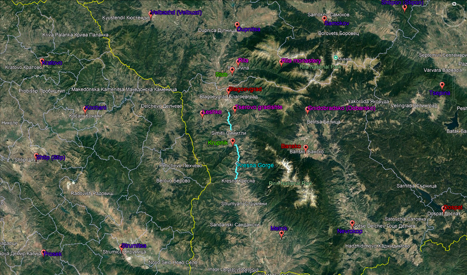
So, I partially agree with your suggestion. If we rationalize that the territory of the monastery is not so much spread and cover only the Rila River’s valley down to Rila town (village back then) then it might work. Otherwise, the reality was different (check the map below). I added only few of the bestowed/mentioned (in Rila charter) villages and the fortress (gradishte) Tserovo, which are marked with pink labels. They are scattered all over the place basically they were enclaves in the neighboring regions. That's why I said that Rila monastery would collide/overlap with Stob. The only purpose (gameplay depth) of such location (small territory, sparsely populated, surrounded by the mountain (one-way in/out)) is to give church bonuses to Orthodox state, which controls it. It might be presented in-game as a holy place. I don't see any other strategic value.

If we go for the suggested by you Melnik province I would pick also candidates like Krupnik and gradishte Tserovo. Krupnik controlled the northern part of Kresna Gorge. (As a side note, this reminds me that Kresna Gorge (pass) should be presented in some way (penalty maybe) in the game because there is strategic value as a choke point). Later, Krupnik became cultural center of the region during the Ottoman period. Tserovo fortress controlled the pass between the modern Blagoevgrad and Simitli. I considered Tserovo at some point but it dropped out because the four Macedonian provinces I proposed became big enough.

Now, when I looked closely northern border of the in-game Blagoevgrad location seems to resemble the northern border of the modern Blagoevgrad Province, which means that Stob currently lays in the in-game Dupnitsa location. Therefore, it should be taken a bit of land from Dupnitsa location for Stob.

8-Rila_Monastery.png
 
Last edited:
  • 4
  • 1
Reactions:
They are scattered all over the place basically they were enclaves in the neighboring regions. That's why I said that Rila monastery would collide/overlap with Stob. The only purpose (gameplay depth) of such location (small territory, sparsely populated, surrounded by the mountain (one-way in/out)) is to give church bonuses to Orthodox state, which controls it. It might be presented in-game as a holy place. I don't see any other strategic value.
St. Ivan Rikski who founded the Monastery in 10th century was already very venerated and the site, which was also his grave, was seen as a wholly site. Logically the villages were already accommodating pilgrims on they way up to the monastery. I would not write it out as insignificant even before the Rila charter. The Rila Charter is only unique to prove, that the vilages and cities of today in western Rila were the same and had the same names. That is rarely a lot of Information documented and would be unwise to not get used in game.
 
Last edited:
  • 1
  • 1
  • 1Haha
Reactions:
I really don't like the names Zagreb and Varaždin, Križevci and Virovitica, Vukovar-Syrmia. They are names for modern administrative divisions created in 1990's.
One alternative is Middle Croatia, Western Slavonia and Eastern Slavonia. I don't like those names either but at least they're better than the 'and' names.
Another set of names could be Croatian Banate, Slavonia and Slavonian Frontier, but they're not that good.
 
  • 1
Reactions:
I really don't like the names Zagreb and Varaždin, Križevci and Virovitica, Vukovar-Syrmia. They are names for modern administrative divisions created in 1990's.
One alternative is Middle Croatia, Western Slavonia and Eastern Slavonia. I don't like those names either but at least they're better than the 'and' names.
Another set of names could be Croatian Banate, Slavonia and Slavonian Frontier, but they're not that good.
"Syrmia" is a pretty old name, so I think it would make sense to use it as a province.
 
  • 1Like
Reactions:
Somewhere in Barcelona, a poor content designer is begging to Pavía: "Please, for the sake of god, let us already publish the review. This will never end. It's a fool's endeavor and we will never be able to release the review if we try to include all new posts." Pavía rejects. "No," he says, "Zeprion just released some Romanian maps. Get to work."
 
  • 15Haha
Reactions:
Somewhere in Barcelona, a poor content designer is begging to Pavía: "Please, for the sake of god, let us already publish the review. This will never end. It's a fool's endeavor and we will never be able to release the review if we try to include all new posts." Pavía rejects. "No," he says, "Zeprion just released some Romanian maps. Get to work."
God is written with big letter,else good.
 
  • 1
Reactions:
Somewhere in Barcelona, a poor content designer is begging to Pavía: "Please, for the sake of god, let us already publish the review. This will never end. It's a fool's endeavor and we will never be able to release the review if we try to include all new posts." Pavía rejects. "No," he says, "Zeprion just released some Romanian maps. Get to work."
*3 months later*

Barcelona content designer: "Hey, we released this updated version of the Carpathian Region, we took into consideration all new posts".

Zeprion remembering when they wrote that post about the Duchy of Maramures yet it wasn't taken into account: "NO, THIS IS SO WRONG! THIS IS THE REAL HISTORY OF MARAMURES THAT YOU FAILED TO ADD IN THE GAME:

The Illustrious Duchy of Maramureș: A Realm of Mud, Myth, and Magnificent Mustaches

Once upon a time, in a faraway land that wasn’t quite sure whether it was Eastern Europe or a particularly eccentric episode of a Monty Python sketch, there lay the Duchy of Maramureș. Nestled between the Carpathian Mountains and a surprising number of sheep, Maramureș is a place where time doesn’t just stand still—it takes a leisurely nap in the afternoon, complete with snoring.

Geography: A Land of Valleys, Hills, and Unintentional Comedy

The geography of Maramureș is best described as a topographical prank. The region is famous for its rolling hills, which are so determined to outdo each other in steepness that they sometimes forget they’re supposed to be hills and attempt to become mountains. These hills are accompanied by valleys that seem to have been designed by a particularly mischievous landscape artist who thought it would be hilarious to see how many small, confused rivers could be made to run in circles.

The Carpathian Mountains, meanwhile, loom over the region like a group of grumpy old men who’ve been interrupted from their nap. These mountains are a perfect backdrop for the various legends and myths that swirl around Maramureș, many of which involve heroic deeds like fetching water from wells located inconveniently halfway up a cliff or outsmarting a particularly clever goat.

In terms of climate, Maramureș enjoys what meteorologists refer to as "weather." This includes an impressive variety of precipitation: rain, snow, sleet, and something the locals call "snizzle," a mysterious mix of snow and drizzle that has baffled scientists and ruined many a perfectly good pair of shoes.

The People: Stubbornly Hospitable and Hilariously Serious

The people of Maramureș are renowned for their hospitality, a trait that they take so seriously that it has become something of an extreme sport. Visitors to the region are immediately subjected to a barrage of food, drink, and offers of marriage to one of the many available cousins, most of whom are named Ion. Refusing these offers is not just considered impolite—it’s practically a declaration of war.

The Maramureșeni, as they’re known, are a proud and stubborn people. This is best illustrated by their traditional clothing, which hasn’t changed since approximately the time of Charlemagne. Men wear enormous sheepskin coats and hats that could double as small bungalows, while women don skirts so layered that they often resemble walking haystacks. These garments are not just for show; they serve the dual purpose of keeping the wearer warm and providing emergency shelter in case of sudden downpours of snizzle.

One of the most cherished customs in Maramureș is the art of mustache grooming. In fact, the mustaches in Maramureș are so impressive that they have been known to receive fan mail. There is a strict etiquette surrounding these facial adornments, and much like in a Jane Austen novel, a gentleman’s social standing can be entirely determined by the size, shape, and twirl of his mustache. There are even annual mustache competitions, where participants are judged on categories such as "Most Resembling a Small Rodent" and "Best Use of Wax in a Non-Candle Application."

Government: The Duke, The Council, and The Committee for the Preservation of Archaic Words

The Duchy of Maramureș is ruled by a Duke, who is chosen through a process known as "inheriting the title because no one else wants the job." The current Duke, His Grace Bogdan the Slightly Bewildered, is known for his unshakeable commitment to maintaining the traditions of the land, as well as his inability to find his reading glasses, which he is usually wearing.

The Duke is assisted by a council of elders, who are tasked with advising him on matters of state, such as whether the annual cheese festival should be moved to avoid coinciding with the sheep shearing extravaganza. These elders are the wisest men in Maramureș, or at least the most experienced at sleeping through long meetings without snoring.

Then there is the Committee for the Preservation of Archaic Words, a body so powerful that it once successfully lobbied to have the word "flibbertigibbet" reinstated into common usage. The Committee’s main job is to ensure that Maramureș retains its linguistic distinctiveness by promoting the use of words that have not been spoken aloud since the days when people thought bathing more than once a month was excessive. As a result, the locals often greet each other with phrases like, "Good morrow, thou hast a visage most splendidly hirsute," much to the confusion of tourists.

Economy: Wool, Wood, and Waffles

The economy of Maramureș is based on three main industries: wool, wood, and waffles. The region is famous for its wool, which is so thick and luxurious that it has been known to trap small birds. This wool is used to make the aforementioned traditional clothing, as well as an alarming number of blankets, all of which are intended to be used simultaneously.

Wood is another crucial component of the Maramureș economy, with the region’s carpenters being particularly renowned for their skill in crafting elaborately carved wooden churches. These churches are a marvel of engineering, being held together by a combination of dovetail joints, prayers, and, according to some, sheer force of will. It is said that the wood from Maramureș trees is so strong that it once successfully defended itself in court against accusations of termite infestation.

Waffles, though a more recent addition to the economy, have taken Maramureș by storm. Introduced by a particularly enterprising baker who got lost on his way to Belgium, these waffles have become a local obsession. There is even a Waffle Festival, where participants compete to create the most outrageous waffle toppings, including such culinary delights as pickled herring with chocolate sauce and bacon-wrapped strawberries drizzled with garlic syrup. The winner receives the prestigious Golden Waffle Iron, which has been known to mysteriously disappear from the Duke’s kitchen during particularly intense competition years.

Festivals and Customs: Celebrating Everything, Including Things That Don’t Exist

If there’s one thing the people of Maramureș love, it’s a good festival. And by "good," I mean "any excuse to wear traditional clothing, eat too much, and possibly start a minor fire." The Maramureș calendar is so packed with festivals that there are days when it’s impossible to walk down the street without tripping over a parade.

One of the most important festivals is the Festival of Mud, which celebrates the region’s abundant supply of mud. The origins of this festival are shrouded in mystery, but it is believed to have started when a group of villagers decided that if they were going to be covered in mud all the time anyway, they might as well make a party out of it. The highlight of the festival is the Mud Wrestling Championship, in which participants battle for the title of "Mud Monarch" and the right to wear a crown made entirely of potatoes.

Another significant event is the Night of the Dancing Goats, a festival dedicated to the region’s most famous and unpredictable livestock. Legend has it that once a year, the goats of Maramureș gather to perform a secretive and highly choreographed dance routine. While no human has ever actually witnessed this event, it is celebrated with much enthusiasm by the locals, who dress up as goats and attempt to outdance each other in a contest that is equal parts impressive and deeply unsettling.

Then there’s the Great Snizzle Festival, held in honor of the region’s unique weather phenomenon. This festival involves the construction of elaborate snizzle sculptures, which are judged on criteria such as "most realistic depiction of a mythical creature" and "best use of accidentally frozen laundry." The winning sculpture is preserved in the town square until it melts, which usually happens about five minutes after the judging.

Conclusion: A Land Like No Other

The Duchy of Maramureș is a place where the past is not just remembered—it’s actively stalking the present with a sheepish grin and a slightly muddied coat. It’s a land where the people are as sturdy as the mountains, as warm as their sheepskin coats, and as delightfully quirky as their favorite myths. Whether it’s the mustache competitions, the waffle festivals, or the enduring mystery of the dancing goats, Maramureș is a place that defies logic, reason, and occasionally the laws of physics.

So, if you ever find yourself in Eastern Europe with a hankering for adventure, a love of absurdity, and a tolerance for unpredictable weather, make your way to Maramureș. Just remember to bring your best mustache, your sturdiest boots, and an open mind—because in this remarkable duchy, anything can happen. And it probably will.

END OF STORY.

@Pavía I'm glad that you keep your workers in check. Please, make sure you give the Barcelona content designer a slap on the head if they refuse to implement the magnificent Maramures moustaches in game. For each palm they take I will buy and giveaway an extra EU5 physical copy. And then hit the Barcelona content designer with the physical copy until I break the disk. As the Warhammer 40:000 Commissars say "Forward, you dogs, to victory!" and "If you'll not serve on the battlefield then you will serve on the firing line".
 
Last edited:
  • 4Haha
  • 1Like
  • 1Love
  • 1
Reactions:
Hi everyone!

I’m a bit late for this discussion but I saw these maps late and I needed some time to prepare this post. As a disclaimer I would like to state that I’m not historian and don’t pretend to be one. I just saw few things that I considered to be inconsistencies and started digging info to back my words. It appeared that the inconsistencies are a bit more than a few hence I ended up writing massive post (it’s a large topic after all). I would like to apologize if I repeat some statements, just couldn’t cover so many pages in this thread. My post mostly concern Bulgaria.
Unfortunately, it appeared that I can't post links due to low post count (that's my first post).


I. POLITICAL MAP
There are some inconsistences concerning Bulgaria in the political map mode. The Bukelon and Plovdiv (called Paldin [pəldin] back then) should not be part of Bulgaria at the starting date. Plovdiv was captured by the Byzantines in 1324 [1]. Then, the regent Anna of Savoy ceded Plovdiv along with eight fortresses (Tsepina, Krichim, Peristitsa, St. Ustina, Stanimaka, Aetos, Byaden and Koznik) back to Bulgarian tsar Ivan Alexander in 1344 as a reward for support against John VI Kantakouzenos during the civil war [2]. Regarding Bukelon, it was captured by Michael Shishman in 1328 but returned to the Byzantines shortly after [3].

Regarding the control of Višesav (correctly spelled as Višeslav or Visheslav), Kozelj, Svrljg, Pirot and Niš cannot be determined so straight forward. In order to determine which state controlled these locations (ate the starting date), the time frame should be rewinded back to the reigns of Shishman of Vidin and Stefan Uroš II Milutin. Serbia started expanding eastward in 1292 by defeating the Darman and Kudelin, capturing in the process Branicevo region along with the key fortresses Ždrelo (Zhdrelo) and Kucevo. Shishman supported by Nogai’s troops attacked Milutin in attempt to claim these territories or in revenge because of Darman and Kudelin fall (there are some assumptions that Shishman was relative to the brothers). Shishman’s campaign failed, which resulted in Milutin’s counter attack and capturing Vidin. This means that Visheslav, Kozelj and possibly Svrljg fell under Milutin’s control as well. However, according to Uzelac, 2011 [4] who cited archbishop Danilo II, the conflict was resolved through the mediation (intimidation) of Nogai. As a consequence, Milutin returned all of Shishman’s possessions, sent his son Stefan Dečanski to Nogai's court, while Shishman (recent widower) married the daughter of Serbian nobleman Dragoš. Moreover, Shishman married his son Michael Shishman (future Bulgarian emperor) to Milutin’s daughter Ana-Neda.

The next conflict between the two states was almost forty years later culminating at the Battle of Velbazhd in 1330. For the aftermath of the battle I’ll quote Fine, 1994 [5]: “Though the sources mention no territorial changes, many scholars believe the Serbs recovered Nis and its region at this time”. There was no other clashes between Bulgaria and Serbia until the starting date. If the sources are correct, we can assume that Višeslav, Kozelj, Svrljg and Pirot were part of Bulgaria at the starting date, while Niš is not so clear.


II. CULTURES

Looking at the demographic (culture) map seems too modern as well.
On another note, change the colors please. You may pick color for Bulgaria and Bulgarian culture similar to this in CK3 or EU4.
I’ll start with Belgrad and Braničevo regions. Their population should be predominantly Bulgarian at the starting date. Those regions were part of the First Bulgarian Empire for almost two centuries (829-1018). During most of this period new Bulgarian culture started to form. The conversion of Bulgaria to Orthodox Christianity (864/866), development of the Cyrillic alphabet and Old Church Slavonic, some cultural advances, along with military successes (especially during Simeon I reign) had a profound effect on the Slavs in the empire, who started associating themselves as Bulgarians. The above mentioned factors basically were the melting pot of the new Bulgarian identity during this period. I’m saying “New” because there were cultural differences to the Old Bulgar culture, even though the administrative apparatus and division didn’t changed at all. Evidence for catalyzed Bulgarian ethnicity we can find in the Bitola inscription (1015) where Ivan Vladislav claimed to be Bulgarian by birth (of Bulgarian kin). This formation of Bulgarian identity is also valid for the Belgrad and Braničevo regions. Belgrad was called in some sources (in Latin) as Alba Bulgarica. During the Byzantine rule (1018-1185(7)), indirect evidence for Bulgarian ethnicity in the Belgrad region was the uprising, led by Peter Delyan. It erupted in Belgrad in 1040 and spread southward to Thessaloniki. Later, during the restoration of the empire, Belgrad and Braničevo were captured relatively early on (1194-1195). Generally speaking, when you restore political entity you first aim to capture provinces/regions where the majority of the population is of your own culture in order to boost the manpower pool and economy (taxation). The Serbs was predominately concentrated in Duklja, Raška and Bosna regions until the middle of the 12th century. Their gradual expansion emerged due to power vacuum caused by disintegration of the Bulgarian Empire and weak Byzantine Empire in the second half of 13th century. They obtained Belgrad, Branicevo, Zdrelo and Kucevo very close to the starting date of the game. Belgrad’s first Serbian ruler was Stefan Dragutin who received it in 1284 as a Hungarian vassal. According to Fine, 1994 [6], Dragutin made an attempt, supported by Hungarian’s troops, to conquer Braničevo region from Darman and Kudelin in 1284 (or 1285) but he failed. The Hungarian support are the keywords here, which implies he didn’t have enough men (Serbian population) in Macva and Belgrad to stand up against the brothers. Later, as I already mentioned in the Introduction section, Braničevo got in Serbian possession in 1292. Although, 13th century was very turbulent (Belgrad and Braničevo changed hands many times between Bulgarian and Hungarians, and later Serbians), I couldn’t find any source claiming forced relocation of Bulgarians from Belgrad, Braničevo, Kucevo or Zdrelo regions. Serbian migration of large masses to such extent to negate Bulgarian majority in those regions is highly unlikely for so short period (1284/1292-1337) because (i) generally the Serbian population was not so large and (ii) these regions were frontier of the Serbian kingdom. Belgrad wasn’t even part of the Serbian kingdom until 1335. The ethnic composition of in-game Belgrad, Smederovo, Braničevo, Ravno, Stalac, Prokuplje and Novo Brdo locations should be mixed (Bulgarians and Serbians) but predominantly Bulgarian, while Kucevo, Kozelj, Svrljg, Nish, Pirot, Glubocica and Vranje should be solid Bulgarian at the starting date. The demography of Nish, Pirot, Glubocica (Leskovats), Vranje and eastern Kosovo was predominantly Bulgarian at least until 1848 according to Ami Boue's map (I can't post links. If you go to Ami Boue page in Wikipedia you will find the ethnographic map of the Balkans). Even the Serbians didn’t consider these four territories and eastern Kosovo to have significant Serbian population at least until the middle of 19th century. Two maps clearly show what the Serbians considered to be lands populated by Serbs – the first one was was created by Dimitrije Davidović in 1828 (If you go to Dimitrije Davidović page in Wikipedia you will find the map) and the second one was created by prof. Konstantin Desjardins in 1853.

Drastic demographic shift in Belgrad, Smederovo, Braničevo, Ravno, Stalac and Kucevo regions took place in the following centuries due to the Black Death, Ottoman conquest and Serbian migration. Moreover, Belgrade was one of the last bastions (enduring until 1521) of the Serbian medieval state resisting the Ottoman invasion. It is expected to have (naturally) some migration of Serbs from lands under Ottoman rule to territories under Serbian control during the whole 15th century.

The composition of Višeslav and Vidin must have been mixed (Bulgarian, Romanian and a bit of Cuman) at starting date. Generally, the ethnic composition immediately next to the both banks of Danube (from Višeslav/Severin to Tulcea/Chilia) was mixed, whereas northern side was predominantly Romanian, while southern Bulgarian. Harsova and Tulcea should be predominantly Bulgarian not another way around.

Significant Albanian and Serbian presence in the in-game Prilep and Vardar provinces is exaggerated for this time period as well, imo. Significant Albanian migration toward western Macedonia and Kosovo took place during the Ottoman Period. I was also surprised to see Albanian presence in Kran location. Regarding Serbian presence in Macedonia, check the maps above (Ami Boue's and Dimitrije Davidović's).

Are there any traces of Cuman culture? There should be some traces in Southern Wallachia, Northern Bulgaria, Kucevo, Visheslav,


References
[1] - "Historia by John Kantakouzenos" in GIBI, vol. X, Bulgarian Academy of Sciences, Sofia, p. 227
[2] - Fine, The Late Medieval Balkans: A Critical Survey from the Late Twelfth Century to the Ottoman Conquest, p. 304.
[3] - Cantacuzenus, vol I, p. 326;
[4] – Uzelac, 2011,Tatars And Serbs At The End Of The Thirteenth Century, p. 14.
[5] - Fine, The Late Medieval Balkans: A Critical Survey from the Late Twelfth Century to the Ottoman Conquest, p. 272.
[6] - Fine, The Late Medieval Balkans: A Critical Survey from the Late Twelfth Century to the Ottoman Conquest, p. 220.
Nis,Svrljig,Pirot were recorded as Serbian after 1330. Since there was no wars between Serbia and Bulgaria border was most likely changed in 1330.
Also we know how border between Serbia and Vidin area looked like due to Ottomans keeping former borders and using them as internal ones.
 
  • 5
  • 3Like
Reactions:
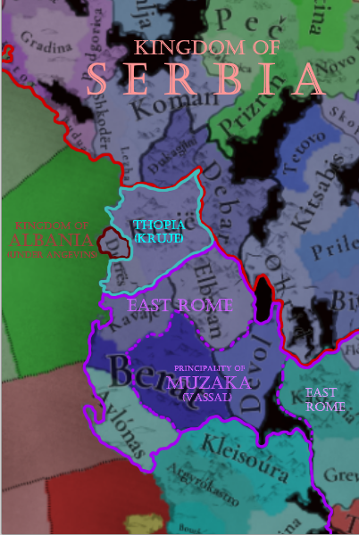
I have a suggestion for Albanian situation, I believe that there should be 2 more TAGs added which would be Thopia family (tag: Kruje) and Muzaka family (tag: Berat)
Current Albanian TAG would be historically depicted in Durres, Thopia dynasty could be depicted as a nominal vassal (or a ally) of Albania.
Muzaka TAG would be depicted as a Vassal state to Byzantium under rule of Andrea II Muzaka.
Byzantium would rule Valona and parts of Central Albania, as Thopia family historically (until Dusan's conquest) only owned territories between Mat and Shkumbin rivers, and Adronicos III (current Byz Emperor at the startdate) campaigned in central Albania in 1335.
Serbia should historically own area north of Mat river as well as Debar.

Now the another suggestion:

If Muzaka or Thopia states would become independent and annex Albanian TAG then either of those tags would inherit the Albanian state and form Albanian TAG (now under Albanian dynasty). This would reflect how Carl Thopia captured Durres in 1368 and after that he would be recognized as "Lord of Albania" in 1370s.


1725363407889.png
 
  • 7Like
  • 2
Reactions: