• We have updated our Community Code of Conduct. Please read through the new rules for the forum that are an integral part of Paradox Interactive’s User Agreement.

Tinto Maps #9 - 5th of July 2024 - Carpathia and the Balkans

Greetings, and welcome to another Tinto Maps! This week we will be taking a look at Carpathia and the Balkans! It will most likely be an interesting region to take a look at, with a lot of passion involved… So I’ll just make an initial friendly reminder to keep a civil discussion, as in the latest Tinto Maps, as that’s the easiest way for us to read and gather your feedback, and improve the region in a future iteration. And now, let’s start with the maps!

Countries:
Countries.png

Carpathia and the Balkans start in a very interesting situation. The Kingdom of Hungary probably stands as the most powerful country in 1337, but that only happened after the recovery of the royal power enforced by Charles I Robert of the House of Anjou, who reined in the powerful Hungarian nobility. To the south, the power that is on the rise is the Kingdom of Serbia, ruled by Stefan Uroš IV Dušan, who has set his eyes on his neighbors to expand his power. The Byzantine Empire, meanwhile, is in a difficult position, as internal struggles ended in Andronikos III being crowned sole emperor, at the cost of dividing the realm; both Serbia and Bulgaria have in the past pressed over the bordering lands, while the Ottomans have very recently conquered Nicomedia. The control over the Southern Balkans is also very fractioned, with a branch of the Anjou ruling over Albania, the Despotate of Epirus under the nominal rule of Byzantium as a vassal, Athens, Neopatria and Salona as vassals of the Aragonese Kings of Sicily, Anjou protectorates over Achaia and Naxos, and only nominal Byzantine control over Southern Morea. It’s also noticeable the presence of the Republics of Venice and Genoa, which control several outposts over the Adriatic and Aegean Seas. A final note: in previous maps, Moldavia was shown in the map, but we’ve removed it from it, and it will most likely spawn through a chain of events in the 1340s.

Dynasties:
Dynasties.png

The House of Anjou rules over Naples, Hungary, Albania, Achaia, and Cephalonia; they’re truly invested in their push for supremacy over the region. Apart from that, each country is ruled by different dynasties, except for Athens and Neopatria, ruled by the House of Aragón-Barcelona.

Locations:
Locations 1.png

Locations 2.png

Locations 3.png

Locations 4.png
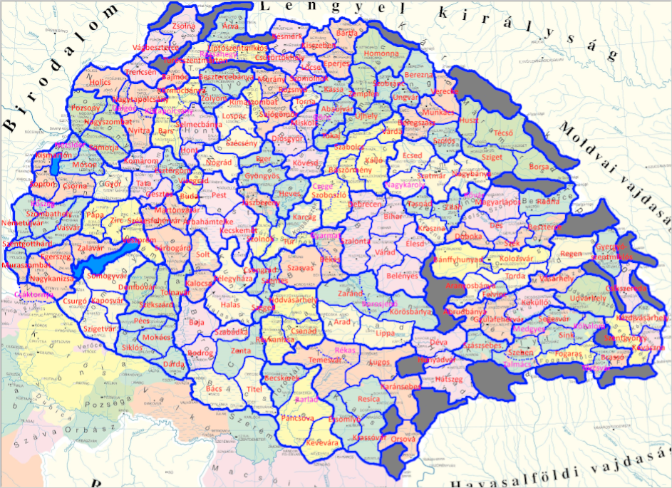
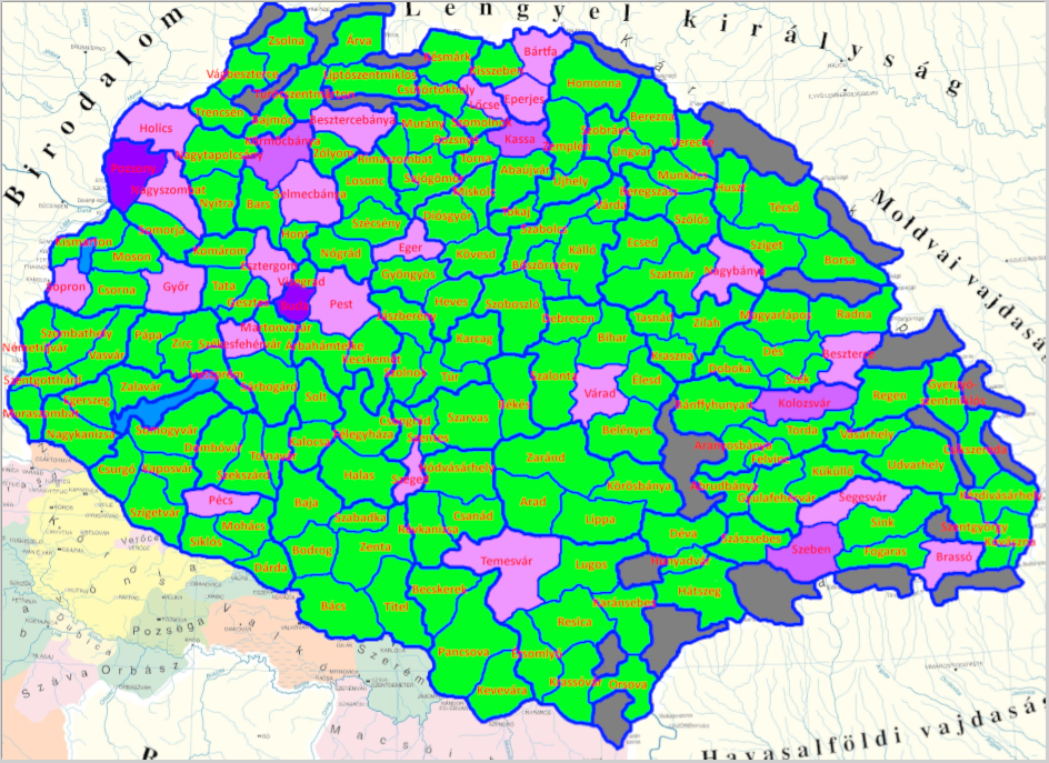
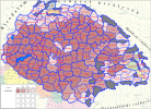
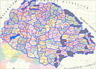
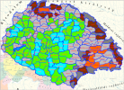
This week we’re posting the general map of the region, along with some more detailed maps, that can be seen if you click on the spoiler button. A starting comment is that the location density of Hungary is noticeably not very high; the reason is that it was one of the first European maps that we made, and we based it upon the historical counties. Therefore, I’m already saying in advance that this will be an area that we want to give more density when we do the review of the region; any help regarding that is welcome. Apart from that, you may notice on the more detailed maps that Crete appears in one, while not being present in the previous one; because of the zooming, the island will appear next week along with Cyprus, but I wanted to make an early sneak peek of the locations, given that is possible with this closer zoom level. Apart from that, I’m also saying in advance that we will make an important review of the Aegean Islands, so do not take them as a reference for anything, please.

Provinces:
Provinces.png

Provinces! Nothing outstanding to be commented on here; as usual, we’re open to any feedback regarding them.

Terrain:
Climate.png

Topography.png

Vegetation.png

Terrain! The climate of the region is mostly divided between Continental and Mediterranean, with some warmer and some colder regions. Regarding the topography, the Carpathian mountains are famously important and strategic, while the Balkans are a quite hilly and mountainous region, which is also greatly covered by woods and forests.

Cultures:
Cultures.png

Here comes the fun part of the DD: The cultural division of the Balkans! A few comments:
  1. Hungary is full of different minorities. Transylvania, especially, is an interesting place: there we have a mix of ‘Hungarians’, ‘Transylvanians’ (which are the Romanian-speaking inhabitants of the region), ‘Transylvanian Germans’, and ‘Szekely’ people.
  2. We have divided the Southern Slavic-speaking region into their dialectal families of Slovene, Croatian, Bosnian, and Serbian.
  3. The Southern Balkans are mostly divided among Bulgarian, Albanian, and Greek cultures.
  4. We’re also portraying plenty of other cultures, such as Dalmatians, Aromanians, Sclavenes, Arvanites, Cumans, Jasz, or Ashkenazi and Romanyoti Jews.

Religions:
Religion.png

This one is also interesting. Apart from the divide between Western Catholicism and Eastern Orthodoxy, we have the Krstjani in Bosnia, Bogomils (the pink stripes both in Bosnia and Macedonia), and Paulicians in Thrace. The Jewish populations do not pass the threshold percentage to appear on the map, but there are plenty of communities across the region.

Raw Materials:
Raw Materials.png

The materials of the region. Something very noticeable is the richness of minerals, with plenty of Iron, Copper, Tin, Lead, Gold, and Silver. Specifically, Slovakia is very rich, and you definitely want more settlers to migrate to the region, and exploit its resources. The region is also very rich in agricultural resources, as you can see.

Markets:
Markets.png

The region is mostly divided among four markets: Venice, Pest, Ragusa and Constantinople.

Country and Location population:
Population 1.png

Population 2.png

Population 3.png

Population 4.png
Country and location population (which I’ve also sub-divided, and is under the Spoiler button).

And that’s all of today! I hope that you find the region interesting; we certainly think that it is. Next week we will go further south, and we will take a look at the Syrian Levant and Egypt. Cheers!
 
  • 193Like
  • 69Love
  • 7
  • 4
  • 3
  • 1Haha
Reactions:
@Pavía Here's the first part of a list of Venetian and Genoese trading posts/colonies they either have in 1337 or had at some point including their translation in Italian(I'm only gonna cover Genoa and Venice but there are other italian republics that have or had a presence in the region and it's plausible that there are still some of their minorities), the locations I put in this list are either the ones present in the game atm or all the islands on which Venice had a presence:
Native name in the game/Venetian/Italian(usually coincides with the Venetian one)

In 1337 Venice directly controls:

Poreč/Parenso/Parenzo
Rovinj/Rovigno
Pula/Pola
(P.s. officially all of Dalmatia was part of Croatia but Venice held a lot of islands and cities on the mainland, it was in 1409 after the king sold Dalmatia to Venice that Croatia lost all of its claims and possessions in the region)
Cres island/Cherso
Lošinj/Lusin/Lussino
Zadar/Zara
Šibenik/Sebenego/Sebenico(in 1337 it was momentary occupied by Venice albeit with low control)
Slano/Slano
Brač island/Braza/Brazza
Hvar island/Łexina/Lesina
Vis island/Lissa
Korčula island/Curzola
Ugljan island/Ugliano
Rab island/Arba
Pag island/Pago
Dubrovnik/Raguxa/Ragusa(by 1337 Ragusa was a vassal with a high degree of autonomy)
Methoni/Modon/Modone
Kythira/Cerigo
Karpathos/Scarpanto
Samothrace island/Samotracia(it should be split from Imbros)

"Kingdom" of Candia:
Chiania/La Canea
Siteia/Sitia
Rethymno/Retimo
Heraklion/Candia
Gramvousa/Grabusa
Ano Viannos/Viannos

Duchy of the Archipelago:
Syros/Siro
Paros/Paro
Naxos/Nasso
Milos/Milo
Andros/Andro
Kythnos/Citno
Sifnos/Sifanto
Thira/Santorini
Folegandros/Policandro
Ios/Io
Amorgos/Amorgo
Kimolos/Argentiera
Anaphe/Anafi
Astypalaia/Stampalia

Triarchy of Negroponte:
Chalkis/Negroponte/Calcide(the bit on mainland is directly controlled by Venice, the part on the island is the capital of the triarchy)
Eretreia/Eretria
Kymi/Cuma Euboica
Klisoúra/Clissura
Oreós/Rio/Oreo
Karystos/Caristo(disputed since it was officially part of Negroponte but the facto controlled by Alfonso Fraderick count of Salona and Malta)
Ptelos(on the mainland but administarted by Negroponte)
Mykonos/Micono(owned privately by Barthlomew II Ghisi one of the three rulers of Negroponte)
Tinos/Tino(same as Mykonos)

In the past they used to rule over:
Trst(Slovene)/Triest(German and friulian)/Trieste(Italian and Venetian)
Biograd/Zaravecia/Zaravecchia
Trogir/Traù
Sporades/Sporadi(technically Venice didn't rule them directly, they were private possessions of the venetian nobleman Geremia Ghisi)
Skyros/Sciro(same as the sporades)
Lemnos/Lemno
Imbros/Imbro
Gelibolu/Gallipoli
Rhaedestus/Rodosto
Split/Spalato(in 1337 it was still owned by Croatia, albeit with pressure from Venice which would fully conquer it in 1420)
Durrës/Durazo/Durazzo
Kerkyra/Corfù(in 1337 it was owned by Charles the duke of Durazzo/king of Albania)
Makarska/Macarsca
Constantinople/Costantinopoli(never fully conquered but they used to have a trading post and there should still be a sizable amount of Venetian pops)

Islands and settlements they will rule in the future:
Rijeka/Fiume
Krk island/Vegia/Veglia(owned in 1337 by the principality of Krk, they were basically indipendent but officially vassals of Croatia)
Novigrad/Novegradi
Knin/Tenin
Metković/Porto Narenta
Kotor/Càtaro/Cattaro
Budva/Budua
Shkodër/Scutari
Lezhë/Alessio
Avlónas/Valona
Bouthorōtón/Butrinto
Párga/Parga
Preveza/Prevesa
Arta
Vonitsa/Vonizza
Leukas island/Santa Maura/Leucade
Kelphalonia/Cefalonia
Zakynthos/Zacinto/Zante
Nafpaktos/Lepanto
Amfissa/Salona
Patras/Patraso/Patrasso
Korinthos/Corinto
Monemvasia/Malvasia
Argos/Argo
Nafplion/Napoli di Romania
Ermióni/Ermioni
Mystrás/Mistra
Oítylo/Vytilo
Kalamáta/Calamata
Élis/Elea
Kyparissía/Arcadia
Kalávryta/Callavrita
Karytania/Caritena
Vostítsa/Aigio
Tripolitsá/Tripolizza
Leukutron/Leuctra
Aegina/Egina
Athens/Atene
Imbros/Imbro
Thessaloniki/Salonico/Salonicco
 
Last edited:
  • 3Like
  • 1Love
Reactions:
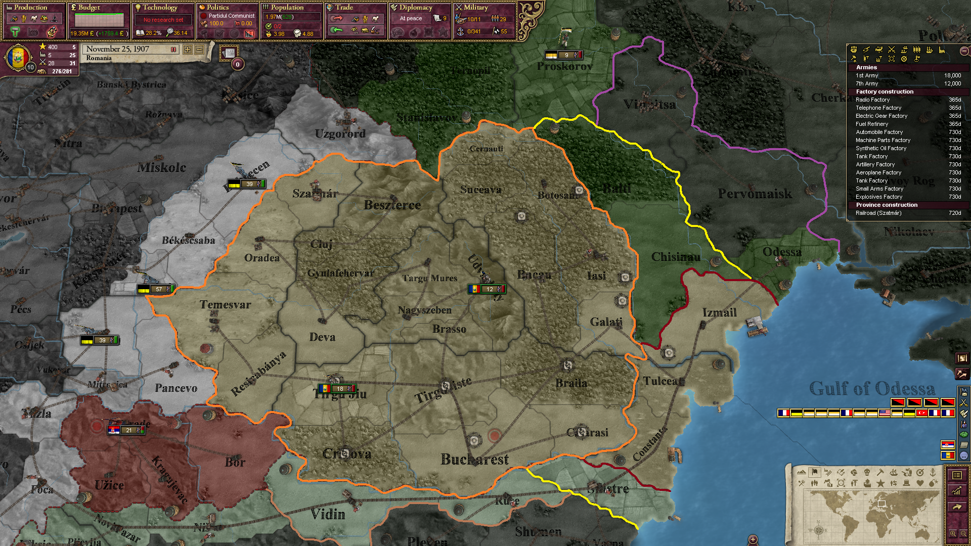
I was wondering if we could get Victoria 2's borders of Wallachia, Transylvania and Moldavia:

zjLk0Gn.png


- Izmail will be taken by the Ottomans to some point. (in EU5's timeline)
- Chisinau & Balti by the Russian Empire at some point. (in EU5's timeline)
- Cernauti and Suceava by the Austrian Empire at some point. (in EU5's timeline)

There is Pokkutia missing but that's about it (see above Cernauti, about 40% of Stanislavov):
img.jpg


Also, the Ottomans took parts of Giurgiu & Braila from Wallachia at some point. Maybe these could be sparate regions too.
 
Hello @Pavía and Tinto,

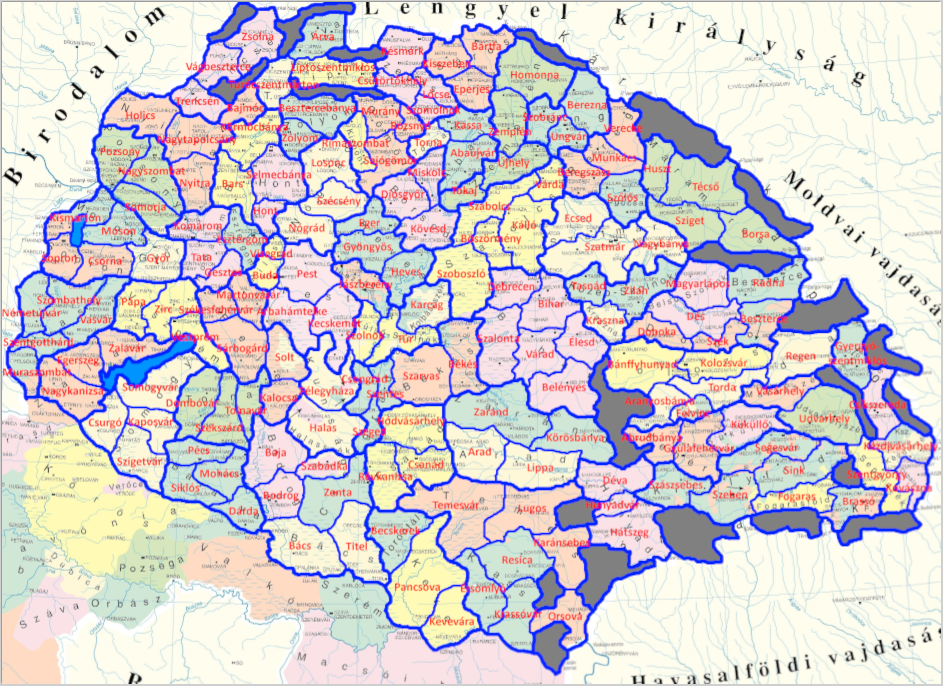
Some time ago myself and @ArVass submitted separate but similar basic proposals on the rework of Hungary, sans Croatia. After enlisting the help of @Mingmung and after many weeks of work, we have combined and expanded our proposals and are presenting them in this post. The basic goal remained the same - to make a much denser and more detailed map that would fit right in with Tinto's design philosophy. We did our best to shape the locations in a similar way to how Tinto would do it - with no splits, few panhandles, and most locations being no more than 3-4x the size of adjacent ones.
Here's our combined product:

Locations and provinces:
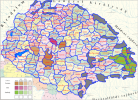
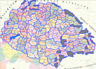
1725912745338.png

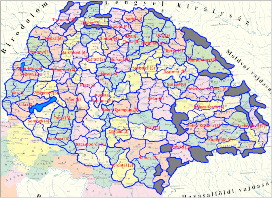
We have doubled the location density and there are now 180 total locations, split across 43 provinces. The location density is highest in Transdanubia as it's adjacent to the HRE, gradually decreasing as you head further east, with some slightly denser spots in the Slovak Ore Mountains, around the Danube and Tisza rivers, and in Transylvania.
Additionally, we added several wastelands (Persanyi and Anina/Semenic in/near Transylvania, two ranges separating Slovakia from Moravia/Silesia, and split a couple in the main range of the Carpathians), as well as Lake Neusiedl/Ferto.
The locations around the edges are a bit imprecise; the borders of the Kingdom of Hungary extended slightly further than this county map shows (this is especially noticeable in Slovakia); however, we left the borders as is since it would have looked a bit weird otherwise (so, for example, trying to match it pixel-to-pixel base on borders is not going to be a good idea). The only place where this could make a meaningful difference on location layout is in the southwest, where the extra territory could allow Nemetujvar to connect to Muraszombat.
1725912846088.png
The provinces are based on 14th-century Hungarian counties. Most counties are split into several locations, based primarily on elevation and rivers, but in rarer cases cultural boundaries (ex: Des-Magyarlapos), known raw materials (ex: Murany-Rozsnyo), or modern borders (ex: Baja-Bodrog). Counties either correspond to a province by themselves, or are grouped with another county or two if they aren't large enough on their own. This was done with historical accuracy in mind whenever possible (for example, Zolyom province includes Arva, Lipto, and Turoc, which were only split off right around 1337, and Gyor-Moson-Sopron is a single province since the three counties were united after Trianon). Locations will generally not include territory from multiple counties, and counties are generally not split between multiple provinces. If a county went on to have special subdivisions (ex: Hajdu District within Szabolcs), we generally tried to represent that as well.
There are a places where these rules were followed a bit loosely - cultural minority areas with designated county seats that would otherwise result in bordergore (Kiralyfold and the Cuman/Jasz lands), areas that were administratively rearranged after the Ottoman conquest (Banat/Vojvodina), the Austrian border, and locations that would be too small on their own (namely Felvinc, where expanding it had other benefits as well).
Two possible historically accurate alternative provinces that we looked at were
1. Hont-Nograd combining half of Hont-Bars, Nograd, and the Kishont location; however, this would leave Bars with two locations.
2. Novum Castrum, including Saros and Abauj-Torna; however, the other part of Novum Castrum (Heves) would be discountinuous, so it wouldn't make sense to include Novum Castrum as an incomplete county.
1725913676408.png

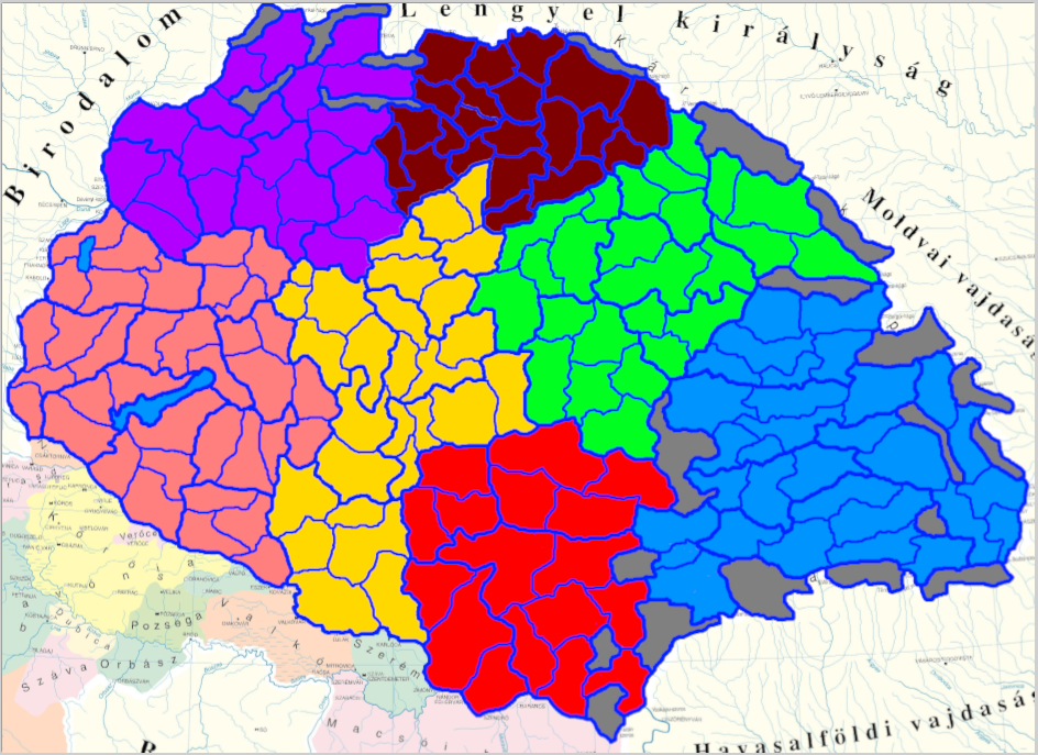
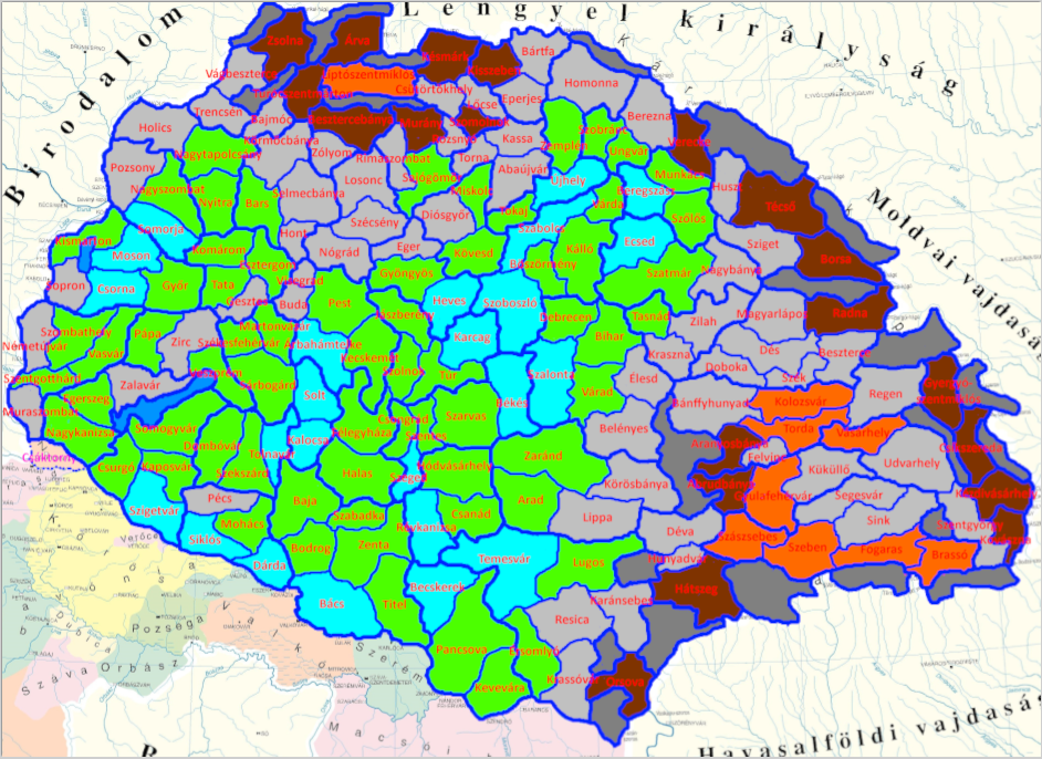
Transdanubia, Alfold or Great Plain, Banat, Transylvania, Partium, East Slovakia or Felvidek (controversial), West Slovakia or Mining Towns
This is probably the most balanced of the possible suggestions that we've considered, but there are several alternative options for how to split provinces into areas; for example, East Slovakia could be divided up between (West) Slovakia and Partium, or Partium and Banat could be combined into Alfold. The suggestion provided is one of the more balanced ones.
There were a few locations that we considered as possible (marked on the map in fuchsia), but for one reason or another did not include them. They are perfectly fine to be included if the reasons against them are judged as trivial, or they could be saved for a future DLC.
1726547017466.png

Koszeg: was a fairly important city; however, it doesn't match the hills across the border in Nemetujvar, it would be a bit too small on its own, and it would have a weird shape if it took too much territory from Szombathely.
Nezsider: it would stop Kismarton from crossing over a county line, but then Kismarton would be pretty small, and Nezsider was only somewhat relevant.
Csaktornya: should absolutely be included, but it would probably be in the Balkans region; however, since it was in Zala county and is located north of the Drava, so it could very reasonably be placed in Zala county/province.
Galgoc: was an important city and would split off the real flatland part from an otherwise hilly Nagytapolcsany; however, I'm just not sure it's needed.
Kistapolcsany: was the capital of Bars county at one point; also, including it could make Bars its own province, while allowing Hont, Nograd, and Kishont to become another historically accurate province. This one was mostly left out to avoid location bloat and would make a good addition otherwise.
Rozsahegy: would make sense since Lipto county is pretty large and has several possible raw materials to choose from; but again I'm just not sure that it's needed.
Gonc: was the capital of Abauj county at one point, and would split southern Abauj into hills+flatlands; however, that would leave two fairly small locations.
Csege: would allow for a sparse-vegetation, horse-producing location to be split off from Szoboszlo; however, it was a barely-populated area, and Csege was only a village.
Gyarmat and Borosjeno: would allow for accurate modeling of 1600's political divisions, which isn't particularly important; however, Zarand is pretty large on its own and splitting Borosjeno off is pretty reasonable.
Rekas: would split a pretty large Temesvar into two smaller ones with a clear terrain divide; however, Temesvar would then acquire a very unusual shape.
Nagykaroly: would split up a fairly large Szatmar and help with even location sizing, but doesn't really offer anything gameplay-wise (it would probably just be Hungarian flat wheat location #457).
Barlad: was barely relevant historically and its only purpose would be to split a large Pancsova.
Kovar: had a separate history from the rest of Zilah even in the 14th century and would be split from Zilah by a clear river boundary; however, it would have a low population, no clear raw material, and not much historical significance.
Medgyes and Kohalom: would improve the shapes of Segesvar and Sink and would represent Saxon seats more accurately, but it would bloat Kiralyfold and the location count in general.
Talmacs and Torcsvar: could provide a mountain location along the Carpathian passes where none currently exist; however, this would probably be better represented by having mountainous locations on the other side.

Topography and Vegetation:
1726975291868.png

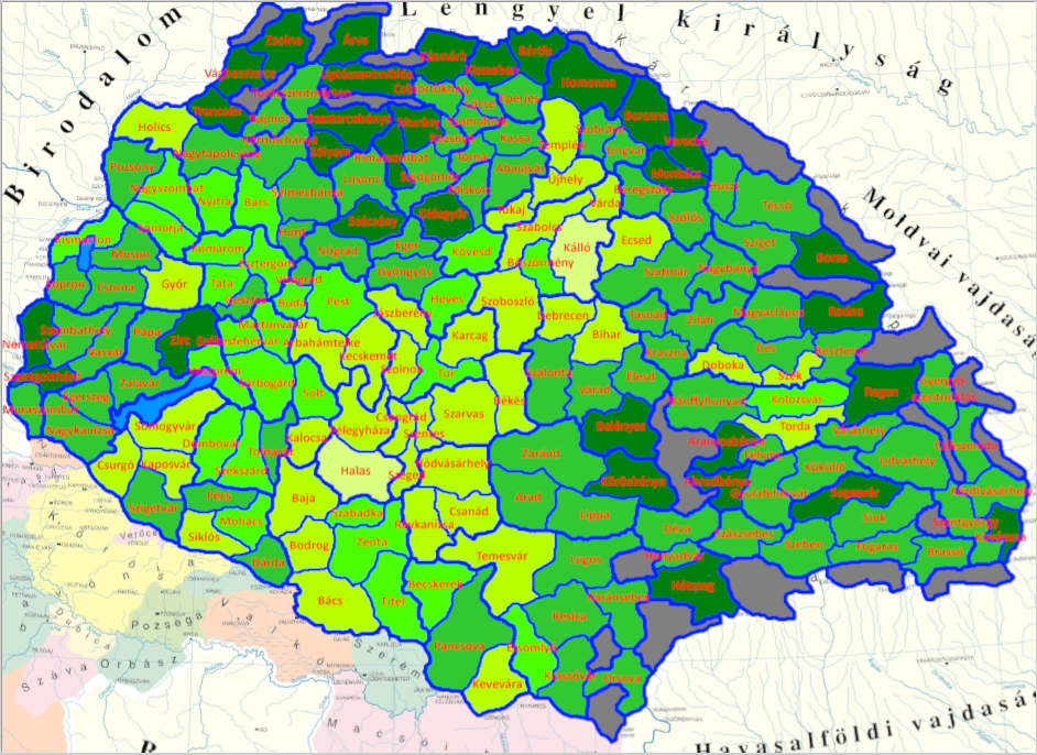
Compared to the original, the suggested elevation map is a lot more diverse. There are a lot more wetlands, especially around the major rivers, to represent the various bogs, swamps, and marshes of the Pannonian plain, as well as some hills in Transdanubia.
There are a few added plateaus in Transylvania around rivers and less hilly areas; of these, Gyulafehervar, Torda, Kolozsvar, and Vasarhely could also be hills, as they do have more variation in terrain than the plateaus further south, but not as much as the hills and mountains around them.
Additionally, Kezdivasarhely and/or Kovaszna could be plateau as well; their land is fairly split between mountains and plateau, but we went with mountains for the sake of a more defensible border, since mountains are now known to block movement during severe winter. If Tulnici in Moldavia remains as mountains, then there is no issue with making either of these two plateau.
The locations across the mountains from Szeben and Brasso should probably be mountains (this includes Campulung Muscel, and @ArVass suggests splitting a Brezoi location from Ramnicu Valcea).
Bartfa is hills since it only reaches about 700m, and Berezna is hills due to its multiple river valleys and not particularly extreme elevation.
1725914232385.png

The forest cover of Hungary in the time period was a bit difficult to determine, but thanks to A map found by ArVass, we have a fairly good estimate based on the 15th century. There are a lot more woods and forests in Western Hungary, as well as two sparse locations to represent the pusztas of Kunsag and Nyirseg.
Farmlands are based mostly on soil quality, with some contribution from raw materials. The largest farmland clusters are in southwestern Slovakia, the Mezofold, and along the Tisza.
Szoboszlo gets an honorary mention as a possible Sparse location due to the presence of the Hortobagy.
Edit: one thing that we didn't find until after posting this is that Kallo would have been wooded for most of the game, and only get deforested (and drained... yeah, it could also be wetlands) around 1800. More on that in the raw materials section.

Raw Materials:
1725915083903.png

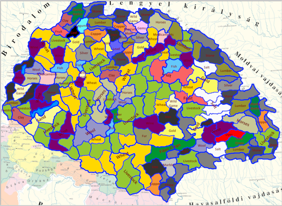
The dominant industry at the time was livestock. Because of this, livestock serves as a "filler" good, especially along the Great Plain and in places where data on alternatives isn't readily available (for example, we don't know how long viticulture has been important in Szarvas, but cattle does well on its grassy expanses).
Horses were also a dominant industry for much of the 14th and 15th centuries before declining in importance; they are much increased in number but livestock remains dominant.
Legumes and wool are a bit less common; Hungarian wool was fairly low-quality, and legumes were often secondary to wheat as an agricultural product.
There is also some fish, as they were an important commodity along the rivers and in some lakes and bogs (for example Ecsed).
Fiber crops were grown throughout large swaths of Carpathia as a low-effort "side hustle" of sorts by peasants; however, they rarely amounted to a relevant industry. For that reason, there are only four fiber crops locations to represent the hemp, flax, and sedge.
Similarly, dyes (woad, weld, and madder) were grown on a small scale throughout the region; it was hard to find a precise location, but they were definitely grown in Southern Transylvania and used for dying wool, so a location where wool was a good secondary option (Segesvar) was chosen to represent this.
Hungary has a large number of wine regions and wine was a relevant economic commodity historically; there are a lot more wine locations to represent this.
Hungary was for a while Europe's largest exporter of gold and silver, and one of the largest exporters of copper. To represent this, there are numerous mines in and around Slovakia and Transylvania, even more than Tinto currently has.
Locse, Szomolnok, and Bajmoc have a material that was only mined in small quantities; these are mostly included for representation of said material. For more info, see next spoiler.
Mercury was mined in Abrudbanya, so if it's removed from Locse, then it could reasonably be put there instead.
Salt is much more spread throughout Transylvania, as it was historically.
Some metal-producing locations produced substantial amounts of other metals too (for example, a mine could produce a lot of gold but also some copper; I recommend using a building to represent this. This would also help with tin production, as there are currently zero tin locations.
Locse and Szomolnok have a... dubious... raw material. The alum in Szomolnok represents a material that wouldn't be discovered and industrially utilized until the 19th century, and the mercury in Locse was mined only in small quantities. Copper, iron, and silver are all reasonable replacements, and honestly it's not unreasonable to just merge Szomolnok into Locse if this is seen as a major issue.
Kallo produced some saltpeter in small amounts, but fruit were probably more relevant. Now that we know that a building that produces saltpeter exists, it should probably be placed in Kallo.
Similarly, small-scale fiber crop production could be represented by a building as well.
-There are multiple locations which would historically change to iron, either after other mines were depleted or after the demand for iron increased during the Industrial Revolution. Lipto, Bartfa, Homonna, Smolnik, all of Gomor-Kishont, and Csikszereda are good candidates for this.
-Belenyes could also start off as copper and change to iron by event.
-Eger has an obscenely large number of possible raw materials based on things that happened in its history over time; I suggest the possibility to change its raw material to clay, wine, or medicaments by event.
-As Cumans decline in military importance and become more settled, the raw material in Felegyhaza should change to something agricultural (for example legumes).
-Kecskemet should at some point in history change to wine + sparse vegetation due to overgrazing.
-Similarly, Kallo could start as wooded + saltpeter and change to sparse + fruit due to deforestation.
-A glassmaking industry arose in the Bukk (so around Diosgyor) at some point; it's unclear where exactly they got the sand from but the most likely option in Heves.
-The salt in Marosujvar (Gyulafehervar location) was forgotten about for a period of time that coincidentally closely matched Project Caesar's timeframe; it could be re-discovered by event.

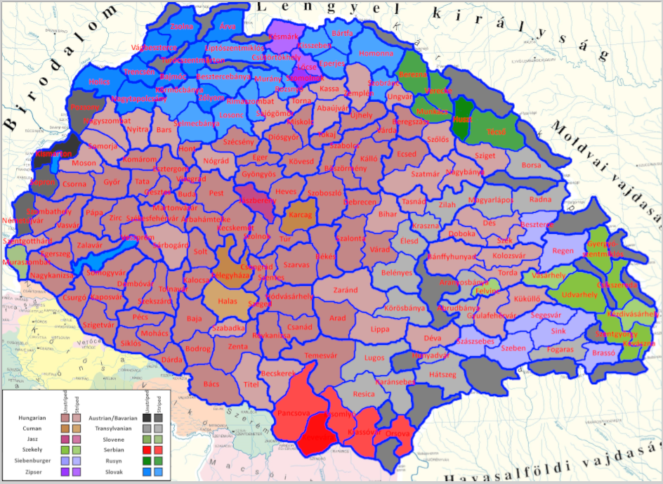
Culture:
1725915552824.png

Since the exact numbers from before the 1800s are very rare, most of this was educated guessing; that said, we feel fairly confident in the overall accuracy even if we got some details wrong. The same idea applies to the spoilered maps below.
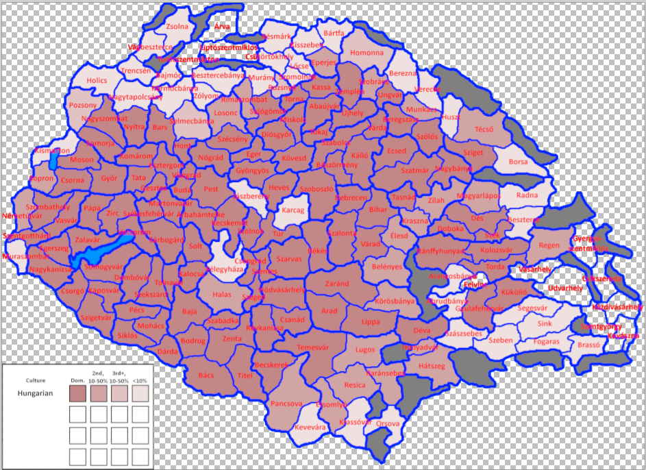
1725915782778.png

Hungarians are present in some number throughout almost all of the Kingdom, and form a majority in its core and parts of Transylvania. The few exceptions are the long-disputed Slovak heartland in the Tatra mountains and the Szekely lands (since there is no good way of determining what counts as "Hungarian" vs "Szekely" there, I just counted all Hungarians in Szekely lands as Szekely).
1725915814645.png

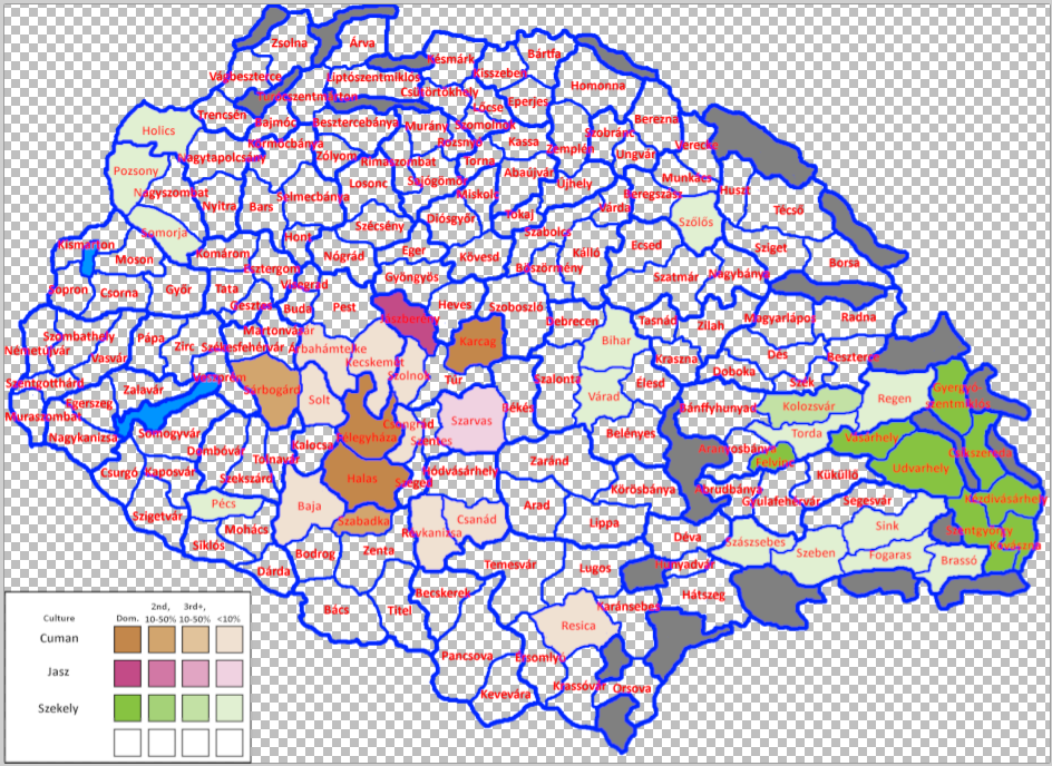
The Cumans form the majority in three locations, but are also scattered in many of the surrounding lands.
The Jasz are present in one additional location, Oroshaza, to represent the nearly-assimilated Kaliz (Khwarezmians).
The Szekely have a bit of a confusing history, but evidence strongly suggests that some of them were present throughout random parts of Hungary, especially the west. In this suggestion, they can still be found in Bihar, Western Slovakia, and a few other spots.
1725915879953.png

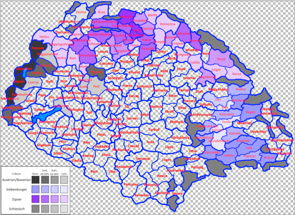
The Siebenburger are present throughout Transylvania.
The Zipsers not only are present throughout most of Slovakia and Transcarpathia, but also form a local majority around Szepes.
The Austrians (Lower Bavarian) are present on the western border, but also around the Danube bend. Some of these are named as just "South German" so they could in theory be Swabians. It's also possible that they made up more than 10% of Buda in 1337 but we can't tell for sure.
There are also a few Silesian Germans in Zsolna.
1725916004815.png

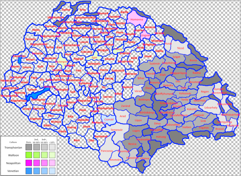
There are a few Wallonians scattered in Esztergom, Eger, and Tokaj.
There are some Neapolitan settlers in the northeast, brought over from their homeland by the Drugeth family.
Csanad has a few Venetians.
The Transylvanians are intermixed throughout their namesake region, and in some places are the majority. Note: in Fogaras and the surrounding areas, it would arguably be more accurate to have Wallachians; however, having Transylvanians makes for simpler and more consistent gameplay.
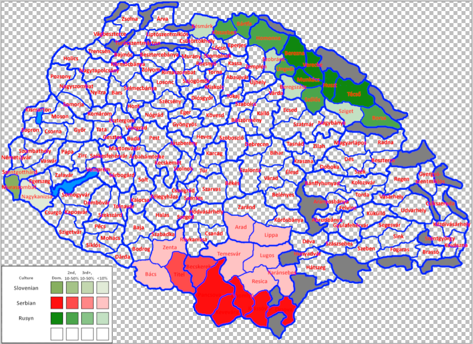
1725916258981.png

The Slovene and Rusyn territories are pretty straightforward. The Serbs are a bit more complicated; it's unclear exactly how many were present in Arad/Lippa/Temesvar/Lugos before the 1400s, but evidence suggests that there were at least a few.
It's also possible that there were even more Slovenes west of Lake Balaton, as it's unclear when they were fully assimilated into Hungarians.
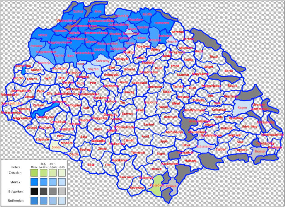
1725916298022.png

There are a few Croats in Szentgotthard and Siklos, and a relatiely large community in Krassovar.
Similarly, there are a few Bulgarians in Orsova and Brasso.
The "Ruthenians" in Szaszsebes and Regen are unclear in exact ancestry; they could correspond to what Project Caesar represents as Rusyns, Ruthenians, Polotskians, or possibly even Muscovites. Unless better sources are found, it may be better to just not represent them.
The Slovaks have been cut in half by the Zipsers, but other than that are plenty numerous. Similarly to Slovenes, they could still have been present in Transdanubia in small numbers, but there isn't much information on when they were assimilated.
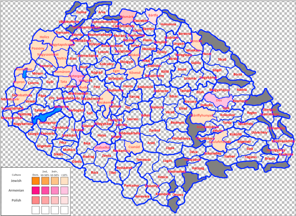
1725916386468.png

There are a few Poles in the north, a few Armenians scattered here and there, and a few Jews. Note: there were probably a lot more locations with Jews, but it's hard to find much info when they were very low in number, so I opted for only putting them in the few shown locations (plus Esztergom, where I can't show both Jews and Armenians on one map).

And one more project from @ArVass :
1725916487882.png

It's unclear what Tinto counts as rural vs town vs city, so we have a few different possibilities presented here. The locations in green are rural; the locations in pink should probably be towns. The locations in light purple should be at least towns and possibly even cities, depending on what is counted as a city, and the locations in dark purple are the most important and those and therefore make the best candidates for being a city.

We are aware of at the work of at least one other group (led by Fehervari) working on another proposal; to the best of our knowledge, his work has much merit to it, as he is including Croatia and has had contributions from actual historians; however, we don't agree with various details of his proposal, such as location shapes, raw materials of uncertain accuracy, and basing areas on minting chambers of all things. Again, his work is probably phenomenal on its own, but doesn't sit well with how we envisioned the split of the region.
 

Attachments

  • 1725915604945.png
    1725915604945.png
    923,1 KB · Views: 0
  • 1725914470011.png
    1725914470011.png
    1,3 MB · Views: 0
  • 1725914084398.png
    1725914084398.png
    963,9 KB · Views: 0
  • 1725915712278.png
    1725915712278.png
    1,2 MB · Views: 0
  • 1726543954746.png
    1726543954746.png
    1,3 MB · Views: 0
Last edited:
  • 11Like
  • 11Love
  • 1
  • 1
Reactions:
I would like to add some additional comments here and there on Photon's amazing post:
Topography and Vegetation:
View attachment 1185596
Compared to the original, the suggested elevation map is a lot more diverse. There are a lot more wetlands, especially around the major rivers, to represent the various bogs, swamps, and marshes of the Pannonian plain, as well as some hills in Transdanubia.
There are a few added plateaus in Transylvania around rivers and less hilly areas; of these, Gyulafehervar, Torda, Kolozsvar, and Vasarhely could also be hills, as they do have more variation in terrain than the plateaus further south, but not as much as the hills and mountains around them.
Additionally, Kezdivasarhely and/or Kovaszna could be plateau as well; their land is fairly split between mountains and plateau, but we went with mountains for the sake of a more defensible border, since mountains are now known to block movement during severe winter. If Tulnici in Moldavia remains as mountains, then there is no issue with making either of these two plateau.
The locations across the mountains from Szeben and Brasso should probably be mountains (this includes Campulung Muscel, and @ArVass suggests splitting a Brezoi location from Ramnicu Valcea).
Bartfa is hills since it only reaches about 700m, and Berezna is hills due to its multiple river valleys and not particularly extreme elevation.
A big trouble we faced in Transylvania was the presence of wide, flat, intermontane valleys, that may or may not be considered valleys of plateaus depending on definition. Another problematic type of location was the type like Brassó; "should we represent the flat plateau at the North, should we represent the high mountains in the South blocking the path towards Cămpulung through Törcsvár, or should we instead try to represent the city itself, which lies exactly at the border of the flatlands and the mountains, taking advantage of the properties of both at the same time?" Most of these ambiguities were resolved by gameplay considerations like Photon said.

View attachment 1185599
The forest cover of Hungary in the time period was a bit difficult to determine, but thanks to A map found by ArVass, we have a fairly good estimate based on the 15th century. There are a lot more woods and forests in Western Hungary, as well as two sparse locations to represent the pusztas of Kunsag and Nyirseg.
Farmlands are based mostly on soil quality, with some contribution from raw materials. The largest farmland clusters are in southwestern Slovakia, the Mezofold, and along the Tisza.
Szoboszlo gets an honorary mention as a possible Sparse location due to the presence of the Hortobagy.
On vegetation, I'd like to mention that there is a lot of ambiguity - some woods along the Carpathians might actually be forests and some in the lowlands might actually be grass or farmlands. There were confusing vegetation changes throughout the centuries (deforestation or reforestation, for example), and there are also areas like the Hortobágy or Nyírség (Szoboszló and Kálló locs) where the vegetation could arguably be sparse or grassland depending on who you ask or what you want to represent.

Raw Materials:
View attachment 1185601
The dominant industry at the time was livestock. Because of this, livestock serves as a "filler" good, especially along the Great Plain.
Horses were also a dominant industry for much of the 14th and 15th centuries before declining in importance; they are much increased in number but livestock remains dominant.
Legumes and wool are a bit less common; Hungarian wool was fairly low-quality, and legumes were often secondary to wheat as an agricultural product.
There is also some fish, as they were an important commodity along the rivers and in some lakes and bogs (for example Ecsed).
Fiber crops were grown throughout large swaths of Carpathia as a low-effort "side hustle" of sorts by peasants; however, they rarely amounted to a relevant industry. For that reason, there are only four fiber crops locations to represent the hemp, flax, and sedge.
Similarly, dyes (woad, weld, and madder) were grown on a small scale throughout the region; it was hard to find a precise location, but they were definitely grown in Southern Transylvania and used for dying wool, so a location where wool was a good secondary option (Segesvar) was chosen to represent this.
Hungary has a large number of wine regions and wine was a relevant economic commodity historically; there are a lot more wine locations to represent this.
Hungary was for a while Europe's largest exporter of gold and silver, and one of the largest exporters of copper. To represent this, there are numerous mines in and around Slovakia and Transylvania, even more than Tinto currently has.
Locse, Szomolnok, and Bajmoc have a material that was only mined in small quantities; these are mostly included for representation of said material. For more info, see next spoiler.
Mercury was mined in Abrudbanya, so if it's removed from Locse, then it could reasonably be put there instead.
Salt is much more spread throughout Transylvania, as it was historically.
Some metal-producing locations produced substantial amounts of other metals too (for example, a mine could produce a lot of gold but also some copper; I recommend using a building to represent this. This would also help with tin production, as there are currently zero tin locations.
Locse and Szomolnok have a... dubious... raw material. The alum in Szomolnok represents a material that wouldn't be discovered and industrially utilized until the 19th century, and the mercury in Locse was mined only in small quantities. Copper, iron, and silver are all reasonable replacements, and honestly it's not unreasonable to just merge Szomolnok into Locse if this is seen as a major issue.
Kallo produced some saltpeter in small amounts, but fruit were probably more relevant. Now that we know that a building that produces saltpeter exists, it should probably be placed in Kallo.
Similarly, small-scale fiber crop production could be represented by a building as well.
-There are multiple locations which would historically change to iron, either after other mines were depleted or after the demand for iron increased during the Industrial Revolution. Lipto, Bartfa, Homonna, Smolnik, all of Gomor-Kishont, and Csikszereda are good candidates for this.
-Belenyes could also start off as copper and change to iron by event.
-Eger has an obscenely large number of possible raw materials based on things that happened in its history over time; I suggest the possibility to change its raw material to clay, wine, or medicaments by event.
-As Cumans decline in military importance and become more settled, the raw material in Felegyhaza should change to something agricultural (for example legumes).
-Kecskemet should at some point in history change to wine + sparse vegetation due to overgrazing.
-A glassmaking industry arose in the Bukk (so around Diosgyor) at some point; it's unclear where exactly they got the sand from but the most likely option in Heves.
-The salt in Marosujvar (Gyulafehervar location) was forgotten about for a period of time that coincidentally closely matched Project Caesar's timeframe; it could be re-discovered by event.
A small note on saltpeter in Kálló; in this area, there was a peculiar method of "harvesting" this salt directly from the ground, which is why we considered making it a saltpeter producing location. This method did not need the resources to be operated as the "usual" chemical-biological method that the saltpeter producing building represents, but rather it really was a form of gathering. However, as Photon mentioned, other industries seem to have been economically more relevant, which is why we ended up not choosing it.

And one more project from @ArVass :
View attachment 1185618
It's unclear what Tinto counts as rural vs town vs city, so we have a few different possibilities presented here. The locations in green are rural; the locations in pink should probably be towns. The locations in light purple should be at least towns and possibly even cities, depending on what is counted as a city, and the locations in dark purple are the most important and those and therefore make the best candidates for being a city.
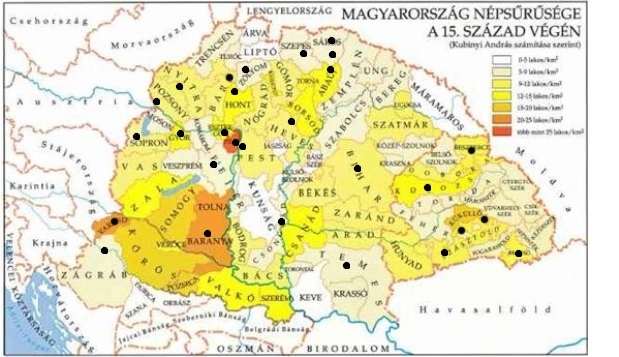
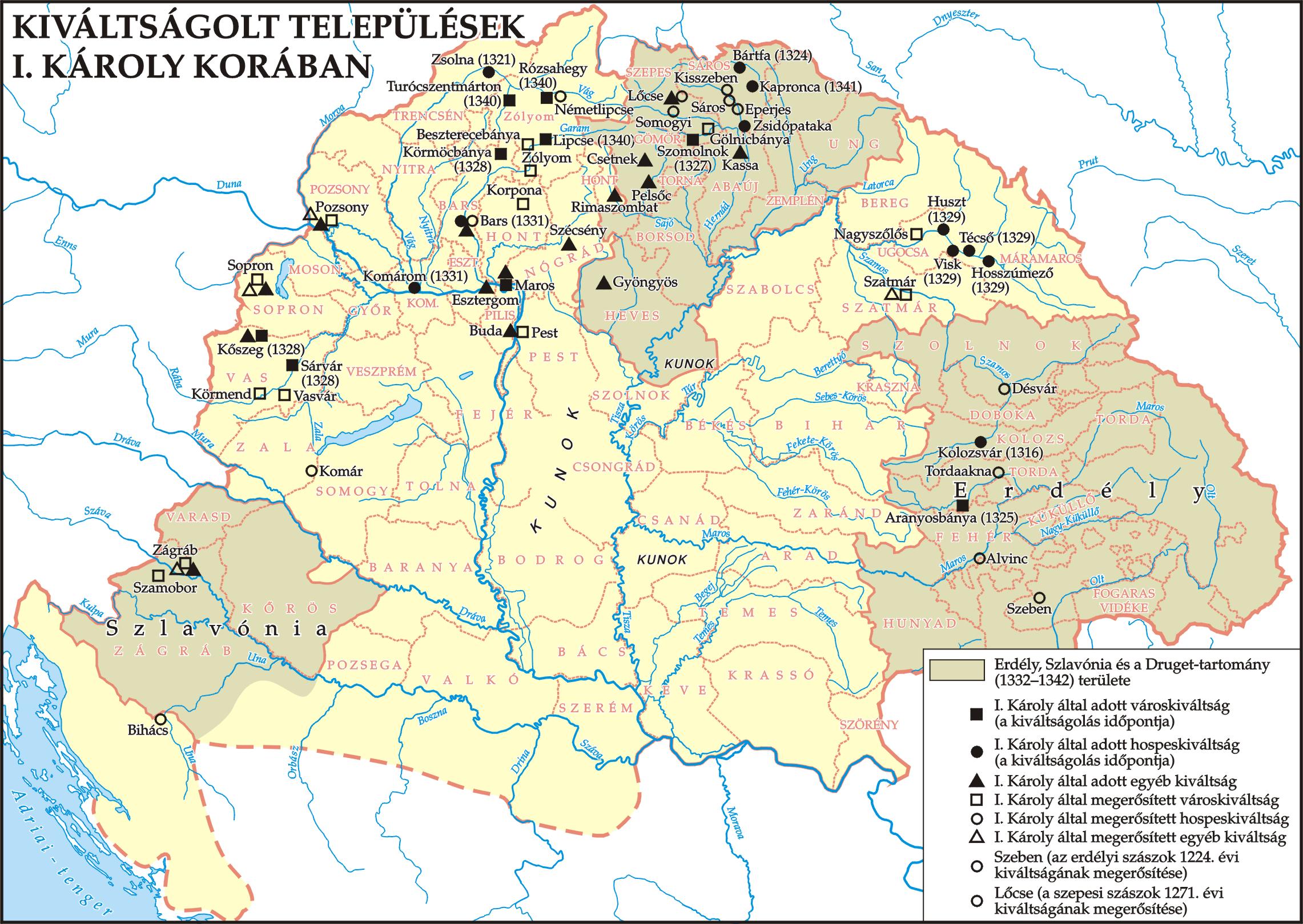
I'd like to add some sources for this; I used lists of free royal cities as one source, and the "Kubinyi-classification" based on the findings of this blog. There are also some maps:

nepsuruseg.jpg

kiváltságolt-települések_városok.jpg

Buda, Pest, Sopron, Pozsony, Nagyszombat, Kassa, Bártfa, Eperjes, Székesfehérvár, Esztergom, Lőcse, Kisszeben were Free Royal Cities at the end of the 15th century, Körmöcbánya, Besztercebánya, Selmecbánya and Nagybánya were important mining towns (a separate cathegory, but equivalent to FRC), although Nagybánya (Asszonypataka) might need to be rural instead. Szakolca was also a FRC, so you technically could switch Holics into Szakolca and make it a town, although it seems to have gained prominence a bit later. Kisszeben got its FRC rights later aswell and also does not have a very high score (K4), so I made it rural for now.
The Saxon cities technically all had similar privileges but I only chose the four largest and most urban (Szeben, Segesvár, Brassó, Beszterce) as towns.
Pécs, Győr, Eger, Várad were important bishoprical seats and belonged to the church, and were large enough to be K-1 or K-2 cathegory by their Kubinyi-score. Nyitra doesn't have its score calculated for some reason, I will have it as rural for now.
Kolozsvár and Temesvár had a very high K-score, so went with towns there despite them being field towns.
 
  • 6Love
  • 4Like
  • 1
Reactions:
evidence strongly suggests that some of them were present throughout random parts of Hungary, especially the west. In this suggestion, they can still be found in Bihar, Western Slovakia, and a few other spots.
I am intrigued by this point, and a bit surprised; as the Székelys were basically a border-defending social caste with privileges, but still basically Hungarian (they will most likely be part of the same culture group, like how e.g. Romanian is also split), it is surprising to represent them in around Pozsony, for example. Could you share some of that evidence, please? I am sure you found it justified to put them there, but I am curious, as I am from those parts and this is news to me.

Aside from this, my only nitpick would be the Somorja-Nagyszombat border, which most likely follows the Little Danube, but feels weirdly straight and soulless (afaik, the river was regulated through the centuries, but was almost as important as the current, main branch)

Great work regardless, between this and Fehervari's upcoming suggestion, I dare not to argue with anything substantial, as exact sources are hard to scrape together as-is.
 
  • 1Like
Reactions:
I am intrigued by this point, and a bit surprised; as the Székelys were basically a border-defending social caste with privileges, but still basically Hungarian (they will most likely be part of the same culture group, like how e.g. Romanian is also split), it is surprising to represent them in around Pozsony, for example. Could you share some of that evidence, please? I am sure you found it justified to put them there, but I am curious, as I am from those parts and this is news to me.
Originally (11th century) they lived all around the border regions on the gyepüelve, and the Székely seats later solidifed into Székelyföld later. There still were Székelys in Baranya around Váty in 1252 (near Pécs), in the late 13th century there were mentions of Székelys around Pozsony in Székelyfalva, Vága etc, and settlements in Bihar (Székelytelek, Székelyhíd, Székelyjó, Mezőtelegd) were most likely the origin of the Székelys of Udvarhelyszék (Telegdszék), so we opted for having these locations still have small numbers of Székelys present.
 
  • 3
  • 2Like
Reactions:
@Pavía Here's the second part of a list of Venetian and Genoese trading posts/colonies they either have in 1337 or had at some point including their translation in Italian(I'm only gonna cover Genoa and Venice but there are other italian republics that have or had a presence in the region and it's plausible that there are still some of their minorities), the locations I put in this list are either the ones present in the game atm or all the islands on which Genoa had a presence:
Native name in the game/Genoese/Italian(usually coincides with the Genoese one)

Aegean/Marmara, Genoa used to rule:

Pera(also known as Galata) was the most important colony in the region inhabited not only by Genoese but also Venetians, Ragusans and other Italic people all governed by the colony's own Podestà who built the famous tower in 1348

Chios/Scio/Chio(it was ruled by Genoa in the past but in 1337 it was owned by the Byzantines who took it in 1329 until Genoa came back in 1346, they should have a core or a claim at least)
Samos/Samo(same story as Chios)
Ikaria/Icaria(same story as Chios)
Ródos/Rodi(it was ruled by Genoa until 1309 when they gave it to the knights which granted them some privileges
Kos/Coo(pretty much same as Rhodes but it was disputed with Venice until recently)
Thásos/Taso(briefly occupied for from 1307 to 1313)
P.s.Crete was also occupied by Genoa for a few years after the 4th crusade

Although they may not have had the best relations in 1337 it is important to know that Genoa still had some influence and people around the islands and coastal settlements owned by the Byzantines despite never owning these ones below thanks to the treaty of Nymphaion of 1261:
Lemnos/Lemno
Thessaloniki/Salonicco
Athína/Atene(also had Venetian and other Italian minorities)
Rhaedestus/Rodosto

Islands and settlements that Genoa will own in the future:
Lesbos/Lesbo(I don't think it's a settlement only an island)
Mytilne/Mitilene
Ainos/Enos/Eno
Samothrace/Samotracia
Imbros/Imbro

Romania/Moldova(Genoa should have some sort of presence in almost all of these by 1337) :

Giorgiu/San Giorgio(not clear if they control it directly but it was probably founded by Genoese merchants so there should be a lot of Genoese people and it had a bank by 1337)
Brăila/Barilla(definitely controlled by Walacchia with some genoese, italian pops and a small trading post)
Galati/Caladda(they have an important trading post, some sources say it became part of Genoa in 1395 until 1445)
Chilia?/Licostomo(we don't know where it was precisely but it was cretaed in 1381 somewhere in the Danube delta, maybe there should be an event for it?)
Costanța/Costanza(they have an important trading post)

The following are fortresses rebuilt on the Dniester river and owned by Genoa to trade and guard against the Romanians, Slavs and Mongols:
Cetateă Alba/Mauricastro(it is the most important trading post in the area definitely owned by Genoa with a fortress)
Tighina/Teghenaccio(small trading post, although first mentioned in 1408 it is theorized that the fortress was built by the Genoese in the 12th cuntury and then captured after the formation of the principality of Moldavia)
Soroca/Policronia(same as Tighina)
Hotin(there ia no translation of this settlement, same as Tighina)
 
Last edited:
  • 2Like
Reactions:
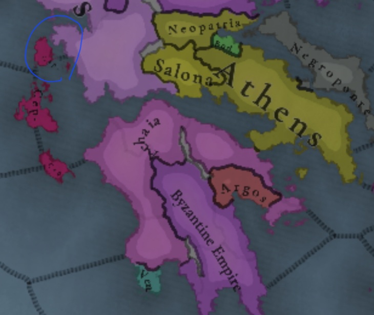
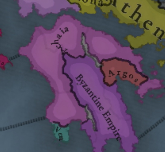
The county Palatine of Cephalonia shoudn't exists in 1337 as a separate entity, if it does then it should be a dominion since it was a vassal of the principality of Achaia and they are both held by the same person Prince Robert of Taranto(he's also the son and heir of the titular Latin empress Catherine of Valois-Courtenay)
Screenshot_20240910_200228_Chrome.jpg
 
Last edited:
  • 1Like
Reactions:
The county Palatine of Cephalonia shoudn't exists in 1337 as a separate entity, if it does then it should be a dominion since it was a vassal of the principality of Achaea and they are both held by the same person Prince Robert of Taranto
View attachment 1186008
I think the coloration suggests it being a vassal (as it's a different tone of purple), but it's a good mention, nonetheless.
 
  • 2Like
Reactions:
The county Palatine of Cephalonia shoudn't exists in 1337 as a separate entity, if it does then it should be a dominion since it was a vassal of the principality of Achaea and they are both held by the same person Prince Robert of Taranto
View attachment 1186008
PUs are handled as an IO rather than a subject relation, so they might be under a PU in this image.
 
  • 3Like
Reactions:
In 1337 the lordship of Argos amd Nauplia was ruled by Walter II(or the VI) Count of Brienne who by 1337 also ruled over the island of Leukás and fortress of Vónitsa conquered in 1331 from the Byzantines and Epirotes during a expedition to reclaim the duchy of Athens of which he's still the titular duke(he should still have cores at the start since his father owned them) from the catalans
Screenshot_20240910_220356_Chrome.jpg
 
Last edited:
  • 1
  • 1Love
Reactions:
No, they're not, Mani is the middle peninsula. The green thing on the western peninsula is Venetian.

That being said, Mani was basically an independent pirate republic at the time, I'd love to have it portrayed as thus.

I'm sure I've got a book about their history, will probably look up the 14th-15th century stuff during the weekend.
Yes the Toparchy of Maina/ Demos of Maina never fell to the Ottomans Turks.
I wrote a bit about it a while ago on paradox forums. Hopefully if theirs later start dates or something it will be shown. As EU4 unfortuntley does not show the free state of Mani.
 
Not just that but I even found this document a while ago

Διασώθηκαν 3 ληξιαρχικές πράξεις από την εποχή εκείνη, είναι αυτές που εξέτασε ό γενεαλόγος Σερίν, κατά διαταγή του Βασιλιά της Γαλλίας Καρόλου Η΄, όταν ο Δημήτριος Στεφανόπουλος από το Καργκέζε υπέβαλλε αίτημα αναγνώρισης ευγενούς Καταγωγής.

Αναφέρεται στην 1η πράξη. «4 Ιανουαρίου 1473. Ενεφανίσθησαν έμπροσθεν εμού, κοινογράφου της Πολιτείας Βυτίλου (Οίτυλο) και κάτωθεν πιστών μαρτύρων από το ένα μέρος ο εξοχότατος Άρχοντας Νικηφόρος υιός του Αυτοκράτορος Δαβίδ Κομνηνού της Τραπεζούντας και από το άλλο μέρος ο Άρχοντας Πέτρος, πατήρ της αρχόντισσας Ελένης την οποία δίδει του άνωθεν εξοχότατου Νικηφόρου διά γυνήν του νόμιμον, καθώς θέλουν οι νόμοι της εκκλησίας».

Στην 2η πράξη διαβάζουμε: «Η συνέλευση της Λακεδαιμονίας Γερουσίας, αναγνώρισε και κατέστησε Πρωτογέροντα τον Νικηφόρο Κομνηνό του Δαβίδ, ορκίζεται δε και υπόσχεται να τον διαφυλάξει από το βαρβαρικό διωγμό».

Και τέλος στην 3η πράξη αναφέρεται: «1 Ιουλίου 1474, γεννήθηκε ένα παιδί, εκ του εξοχότατου Νικηφόρου υιού του Αυτοκράτορος Δαβίδ της Τραπεζούντος και της αρχόντισσας Ελένης του άρχοντα Πέτρου, εμυράνθη και ονομάσθη Αλέξιος από εμένα τον Αρχιερέα Βιτύλου».

Ο Αλέξιος βαπτίζεται την 1η Σεπτεμβρίου του ιδίου έτους. Παντρεύεται με συμβόλαιο την 12η Ιουλίου του 1512 και με θρησκευτική τελετή την 6η Ιανουαρίου του 1513.

Act 1: "In the 4th of January, 1473 AD. In front of me, the scribe of common affairs of the Republic of Vitylon (Oitylo), and many witnesses listed, appeared from one part his excellency the Archon Nikephoros, son of the Emperor David Komnene of Trapezounta (Trabzon) and the other part the Archon Petros, father of the noblewoman Helen, who he gives to the Nikephoros above as legal wife, the way the laws of the Church command"

Act 2: "The counsil of the Lacedemonian Senate recongizes Nikephoros Komnenus of David,[as citizen of the Republic of Mani] and accepts him as an Elder [of the state], also swears and promises to protect him from barbarian persecution [from the Ottoman Turks, for being the son of the last Roman Emperor]"

Act 3: "In the 1st of July of 1474, a child was born from his excellency Nikephoros, son of the Emperor David of Trapezounta (Trabzond) and the noblewoman Helen of Petros, wiped in essence (baptized) and was named Alexios by me the Archibishop of Vitylon (Oitylo)"

Commentary: The above are said to have been discovered in a medieval registration document, with the arrivals of permanent settles, acceptance of citizens and other political affairs, marriages, weddings and deaths. In a few words, it describes how Nikephoros Komnenos reached the Republic of Mani after escaping the Fall of Trabzond, and there he became a permanent citizen accepted as lord and part of the Senate, who married there, had a son there and baptized him there. This Alexios Komnenos was one of the first Maniot Komnenoi. However, while Nikephoros was honored for his being son of a Roman Emperor, he was not accepted as such, because then the Roman State had become a Republic once more and the remaining free Romans had given up Octavian's imperial institution with the death of Constantine IX Dragatses Paleologos.
 
  • 1Love
Reactions:
The ownership of Nish is unclear in the 1330s. It might have been ceded to Serbia as a part of the peace treaty after the Battle of Velbazhd as some scholars suggest. But it might have been part of another deal we don’t know about in the later decades. I guess we would never know for sure unless some source resurface. It is clear that was part of the Lazar’s domain but it is some 50 years later.


Regarding Pirot, I have the feeling that you misinterpreted the text you posted. The text says that Lazar’s vojvoda Dimitrije captured Pirot after 1386. Check slightly different version of your text below. This page is from Colin Imber’s “The Ottoman Empire 1300–1481” book. Imber cited anonymous Ottoman source from 15th century, which was part of later compilation of sources gathered by Nesri. It seems that Lazar captured Pirot after the battle at Plochnik (1386 or 1387).
View attachment 1185130


The starting date of Poganovo Monastery construction is contested. But let assume that starting date is in 1395 as some suggest, a bit before Konstantin Dragaš death. At this point this region was under Ottoman control. Konstantin Dragaš was Ottoman vassal since the very beginning of his reign in 1378. It is very plausible that Dragaš received the land around the monastery as a reward of being loyal vassal. It can hardly prove anything.
Ownership of Nis itself is considered to be Serbian from 1330, due to lack of any military conflict with Bulgaria, since there is no evidence that it was Bulgarian after 1330 I see no issue here, and fortress of Koprijan (south of Nis) was recorded as Serbian during Lazar's rule in 1372 (before Ottoman attack on Lazar's domain)

For Nesri, we need to have his claims with grain of salt, as he was 15th century Ottoman source; Ottoman chroniclers in that time had their own issues with recalling 14th century events the most notably "Battle of Serb destruction(1364)" which was fabricated (or Ottoman sources mixed up historical Battle of Maritsa(1371) and believed that there were actually 2 battles, contrary to 14th century europian sources).

Altho monastery of Poganovo was built way after 1330s, it was still in the area that had nothing to do with Ottoman incursion in Moravian Serbia which led to Battle of Plocnik, and there is no evidence of any land transfer that accured between Ottoman state and domain of Dejanovici post Maritsa, so your opinion on that part was empty presumption.

As for Pirot I will need some time to look into more sources, so I will have to take some time for another responce.
 
  • 1Like
  • 1
  • 1
Reactions:
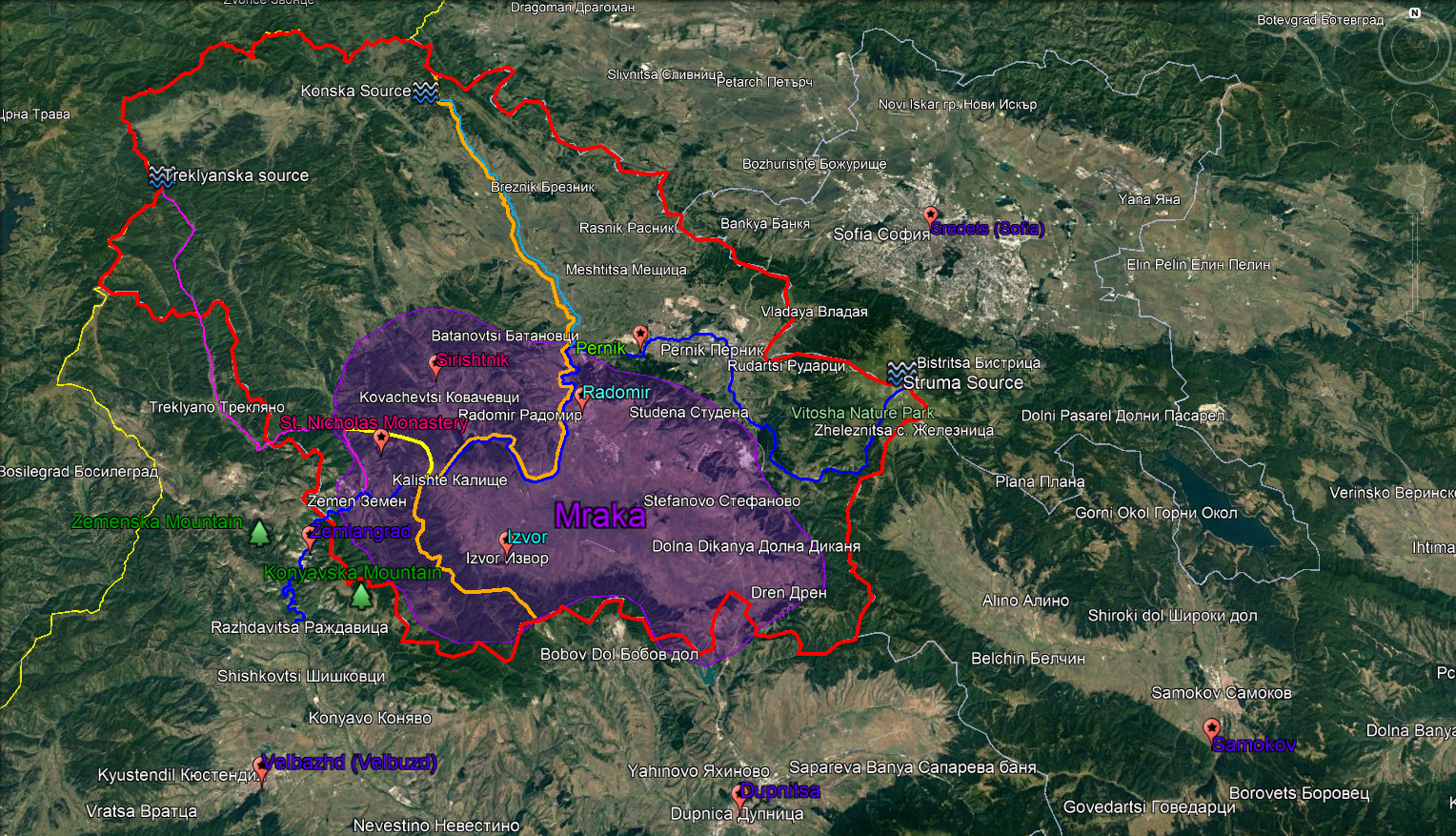
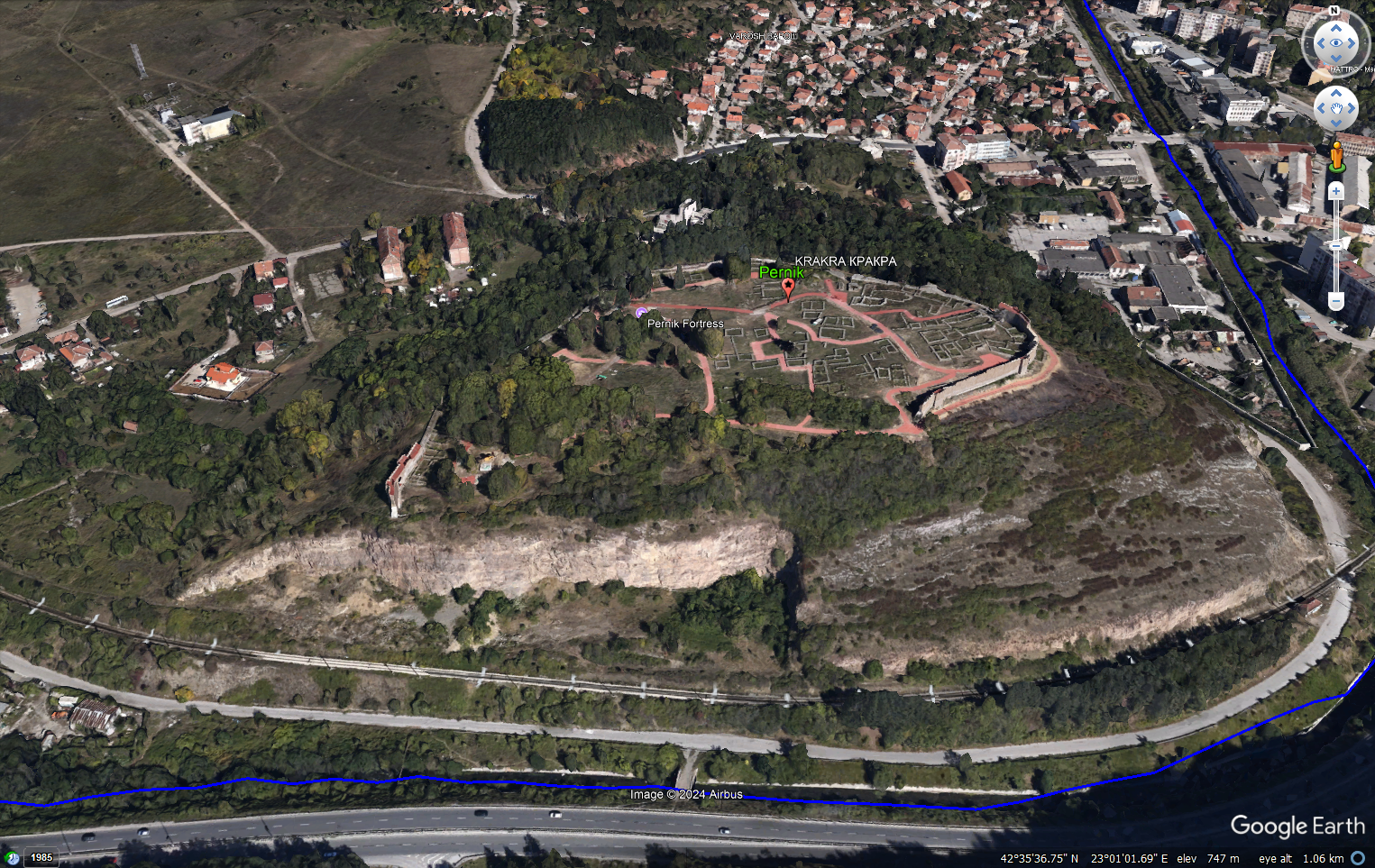
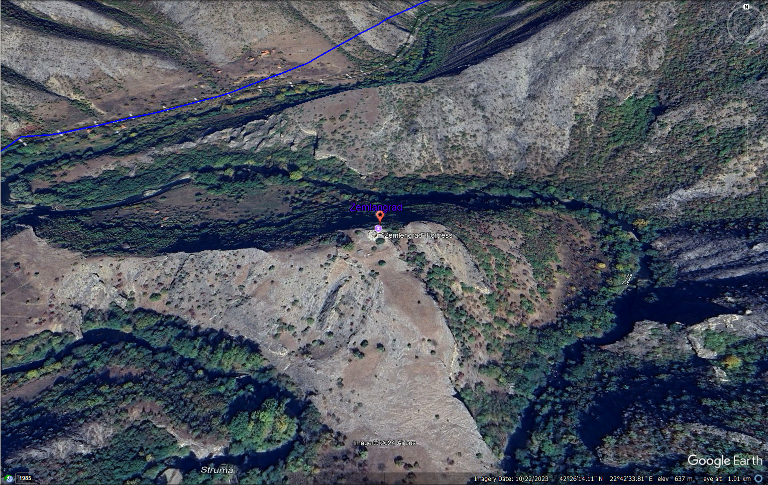
I would like to expand more on the vikinglord’s suggestion (post #482 on p. 25) about Pernik (fig. 2). Zemlangrad location should be split mostly because the whole territory was not under Serbian control in 1337. Moreover, the devs gave too much credit of Zemlangrad regarding territory. Its sphere of control was limited to the gorge (Zemenski prolom where Struma divides Konyavska and Zemenska Mountains) as well as some villages around Treklyanska River (purple curve on fig. 1). Zemlangrad (fig. 3) grew in significance sometime in the second half of 13th century when became border fortress first under Byzantine control then Serbian. It used to defend/control the gorge, which leads to the valley around Velbazhd. Although the economic significance of Pernik started to diminish around the end of 12th century it was not less significant (militarily and economic) than Zemlangrad in 1337.

Pernik-Zemlangrad.png

Fig. 1. Map proposal for division of Zemlangrad location


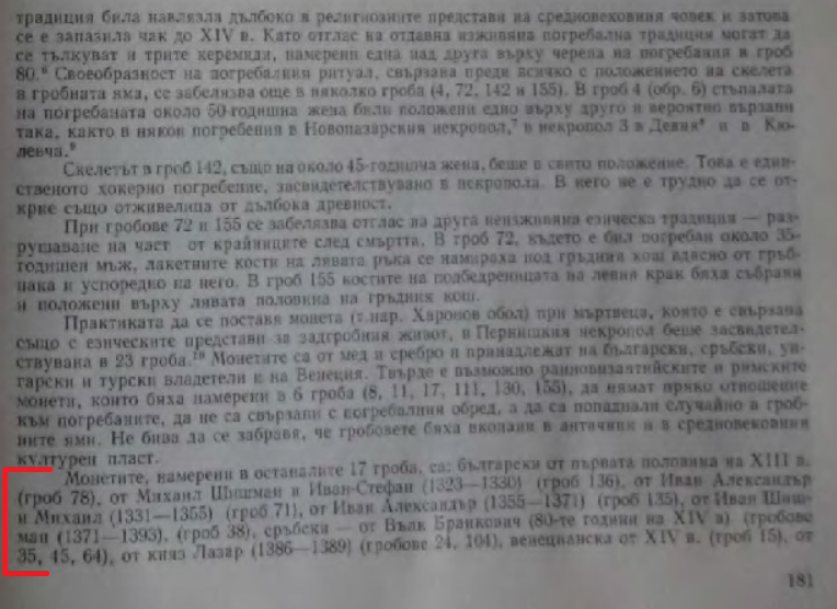
First we have to determine the border between the two locations because this will be the border between Bulgaria and Serbia in-game in 1337. Of course, accurate border is impossible to draw due to lack of information about it, which is evident in the bickering between Bulgarian and Serbian historiographies about the topic for over a century. Nevertheless, we can draw some “reasonable” border for in-game purpose. As I said the information about the border between Bulgaria and Serbia is scarce. But, let start with the information we know about the situation in 1337. We can definitely say that Zemlangrad and St. Nicholas Monastery (aka Mrachki Monastery or Oryahov Monastery) (check fig. 1) were Serbian after the battle at Velbazhd. Archbishop Danilo II explained in his “Lives of Serbian kings” that after the battle king Stefan Dečanski entered to the Mraka area (purple tinted area on fig. 1) [1] then moved to a place called Izvori (modern Izvor), which was in the Bulgarian territory [2]. Regarding Pernik we know through archeological discoveries that was under Bulgarian control in 1337. The coins found in the graves at the necropolis nearby Pernik fortress from the first half of 14th century were only Bulgarian – Michael Shishman/Ivan-Stefan (1323-1330), Ivan Alexander/Michael (1331-1355), Ivan Alexander (1355-1371) [3]. The discovered Serbian coins were from the end of 14th century - Vuk Branković (1380s) and prince Lazar (1386-1389). So there are four places (two under Bulgarian and two under Serbian control) on the map. Most Bulgarian scholars tend to draw border following the Treklyanska River downstream then the border, near of St. Nicholas Monastery, takes weird turn (the yellow curve in fig. 1) without any regard for topographic features, which were used back then for borders (you can see it even in Antimonum’s post #774 on p. 39). Then the border follows the northern ridge of Konyavska mountain in some cases or Konyavska mountain foot in others. In similar manner Serbian scholars draw border east of Struma River without taking into account that Izvor would be weirdly isolated from the rest of Bulgaria. However, there are historians like Georgi Kovachev [4] who suggest more realistic scenario in which Mraka was split between Bulgaria (eastern part) and Serbia (western part) using Struma for border. I’m not going to bore you with some specifics, so long story short, Kovachev argues about the possibility that during the Ottoman period Sirishtnik nahiyah (western part of Mraka) and Radomir nahiyah (eastern part of Mraka) were reflection of this Bulgarian-Serbian division. Frankly, it is really strange that this small village Sirishtnik was center of nahiyah and was not part of the Radomir nahiyah. Unfortunately, the research of the author is focused mostly on Mraka and Radomir, and does not provide information (suggestions) for the Serbian-Bulgarian border outside of Mraka, more specifically northward direction. So, I’ll try to explore few possibilities. If we assume that the border starts from the Struma source downstream to modern village Kalishte (right side to Serbia and left to Bulgaria) then Pernik and eastern part of Mraka would be too isolated (detached from Sredets) hence impossible to be defended by Bulgaria. The region would be reachable only from Samokov through some difficult mountain trails in Verila and Vitosha. This is highly unlikely because the area would be exposed from south, west and north, thus Serbia would have conquered the region very easily. Moreover, Pernik fortress was on the Struma’s right side. More realistic border should be other topographic feature. My suggestion is the right tributary of Struma – Konska River (the light blue curve in fig. 1). The source of Konska is very close to the northern border of the modern Pernik province.

So, here is my final suggestion for in-game border (orange curve in fig. 1) between Pernik and Zemlangrad as well as Bulgaria and Serbia. It starts from the source of Konska downstream until flows into Struma, then follow Struma downstream to modern village Kalishte, thereafter via the northern ridge of Konyavska Mountain until it crosses the southern border of modern Pernik province. I’m not 100% sure but it looks like the borders of Zemlangrad location follow the borders of the modern Pernik province (red curves in fig. 1). As a side note, if this is the case the devs should keep in mind that medieval Zemlangrad fortress is outside the modern Pernik province, few kilometers southward. The modern Zemen (formerly known as Belovo village until 1925) was not built on the same spot as Zemlangrad.


Pernik_fortress3.png

Fig. 2. Satellite picture of Pernik fortress


Zemlangrad_fortress.png

Fig. 3. Satellite picture of Zemlangrad fortress


Bibliography
[1] Daničić (1866). Arhiepiskop Danilo i drugi. Životi kraljeva i arhiepiskopa srpskih, p. 193 (in Serbian)
Danilo_Ref_1.png


[2] Daničić (1866). Arhiepiskop Danilo i drugi. Životi kraljeva i arhiepiskopa srpskih, p. 193 (in Serbian)
Danilo_Ref_2.png


[3] Перник, Том ІІ, Издателство на Българска академия на науките, София, 1983, стр. 181-182 (translation: Pernik, vol. 2, Publishing House of Bulgarian Academy of Sciences, Sofia, 1983, p. 181 (in Bulgarian))
Note: Unfortunately, the quality of the page I have is terrible.
Ref3_Pernik.png


[4] Ковачев, “Мрака и радомирско през средновековието и възрожденската епоха IV-XIX век”, Радомир, 2007, стр. 146-166 (translation: Kovachev, “Mraka and Radomir during the middle ages and Bulgarian National Revival 4-19 century”, Radomir, 2007, p. 146-166 (in Bulgarian))
 
Last edited:
  • 6Like
  • 2
Reactions:
Not just that but I even found this document a while ago

Διασώθηκαν 3 ληξιαρχικές πράξεις από την εποχή εκείνη, είναι αυτές που εξέτασε ό γενεαλόγος Σερίν, κατά διαταγή του Βασιλιά της Γαλλίας Καρόλου Η΄, όταν ο Δημήτριος Στεφανόπουλος από το Καργκέζε υπέβαλλε αίτημα αναγνώρισης ευγενούς Καταγωγής.

Αναφέρεται στην 1η πράξη. «4 Ιανουαρίου 1473. Ενεφανίσθησαν έμπροσθεν εμού, κοινογράφου της Πολιτείας Βυτίλου (Οίτυλο) και κάτωθεν πιστών μαρτύρων από το ένα μέρος ο εξοχότατος Άρχοντας Νικηφόρος υιός του Αυτοκράτορος Δαβίδ Κομνηνού της Τραπεζούντας και από το άλλο μέρος ο Άρχοντας Πέτρος, πατήρ της αρχόντισσας Ελένης την οποία δίδει του άνωθεν εξοχότατου Νικηφόρου διά γυνήν του νόμιμον, καθώς θέλουν οι νόμοι της εκκλησίας».

Στην 2η πράξη διαβάζουμε: «Η συνέλευση της Λακεδαιμονίας Γερουσίας, αναγνώρισε και κατέστησε Πρωτογέροντα τον Νικηφόρο Κομνηνό του Δαβίδ, ορκίζεται δε και υπόσχεται να τον διαφυλάξει από το βαρβαρικό διωγμό».

Και τέλος στην 3η πράξη αναφέρεται: «1 Ιουλίου 1474, γεννήθηκε ένα παιδί, εκ του εξοχότατου Νικηφόρου υιού του Αυτοκράτορος Δαβίδ της Τραπεζούντος και της αρχόντισσας Ελένης του άρχοντα Πέτρου, εμυράνθη και ονομάσθη Αλέξιος από εμένα τον Αρχιερέα Βιτύλου».

Ο Αλέξιος βαπτίζεται την 1η Σεπτεμβρίου του ιδίου έτους. Παντρεύεται με συμβόλαιο την 12η Ιουλίου του 1512 και με θρησκευτική τελετή την 6η Ιανουαρίου του 1513.

Act 1: "In the 4th of January, 1473 AD. In front of me, the scribe of common affairs of the Republic of Vitylon (Oitylo), and many witnesses listed, appeared from one part his excellency the Archon Nikephoros, son of the Emperor David Komnene of Trapezounta (Trabzon) and the other part the Archon Petros, father of the noblewoman Helen, who he gives to the Nikephoros above as legal wife, the way the laws of the Church command"

Act 2: "The counsil of the Lacedemonian Senate recongizes Nikephoros Komnenus of David,[as citizen of the Republic of Mani] and accepts him as an Elder [of the state], also swears and promises to protect him from barbarian persecution [from the Ottoman Turks, for being the son of the last Roman Emperor]"

Act 3: "In the 1st of July of 1474, a child was born from his excellency Nikephoros, son of the Emperor David of Trapezounta (Trabzond) and the noblewoman Helen of Petros, wiped in essence (baptized) and was named Alexios by me the Archibishop of Vitylon (Oitylo)"

Commentary: The above are said to have been discovered in a medieval registration document, with the arrivals of permanent settles, acceptance of citizens and other political affairs, marriages, weddings and deaths. In a few words, it describes how Nikephoros Komnenos reached the Republic of Mani after escaping the Fall of Trabzond, and there he became a permanent citizen accepted as lord and part of the Senate, who married there, had a son there and baptized him there. This Alexios Komnenos was one of the first Maniot Komnenoi. However, while Nikephoros was honored for his being son of a Roman Emperor, he was not accepted as such, because then the Roman State had become a Republic once more and the remaining free Romans had given up Octavian's imperial institution with the death of Constantine IX Dragatses Paleologos.
Wait, is this saying that the Komnenoi survived the fall of Trebizond by hiding out with the Mani?? And that the Mani considered themselves to be a new Roman Republic???

This is so fascinating
 
  • 1Like
Reactions:
Here some suggestions for areas


MOESIA: in-game provinces Shopluk, Vidin, Tarnovo, Silistra and Dobruja (or suggested by me Sredets, Bdin, Tarnovo, Shumen and Karvuna)

THRACE: in-game provinces Zagore, Rhodopes, Evros, Dardanelles, Byzantion, Edirne and Burgas (or suggested by me Paldin, Boruy, Rhodopes, Dimotika, Dardaneli, Tsarigrad, Odrin and Burgas)

MACEDONIA: in-game provinces Prilep, Vardar, Pirin, Chalkidiki, Upper Macedonia and Lower Macedonia (or suggested by me Devol, Prilep, Skopie and Solun)

POMORAVIE: in-game provinces Šumadija (Belgrad), Braničevo (Branichevo), Toplica, Niš (Nish) and Kosovo
 
Last edited:
  • 3
Reactions: