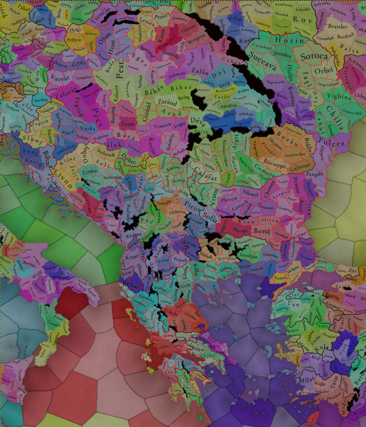
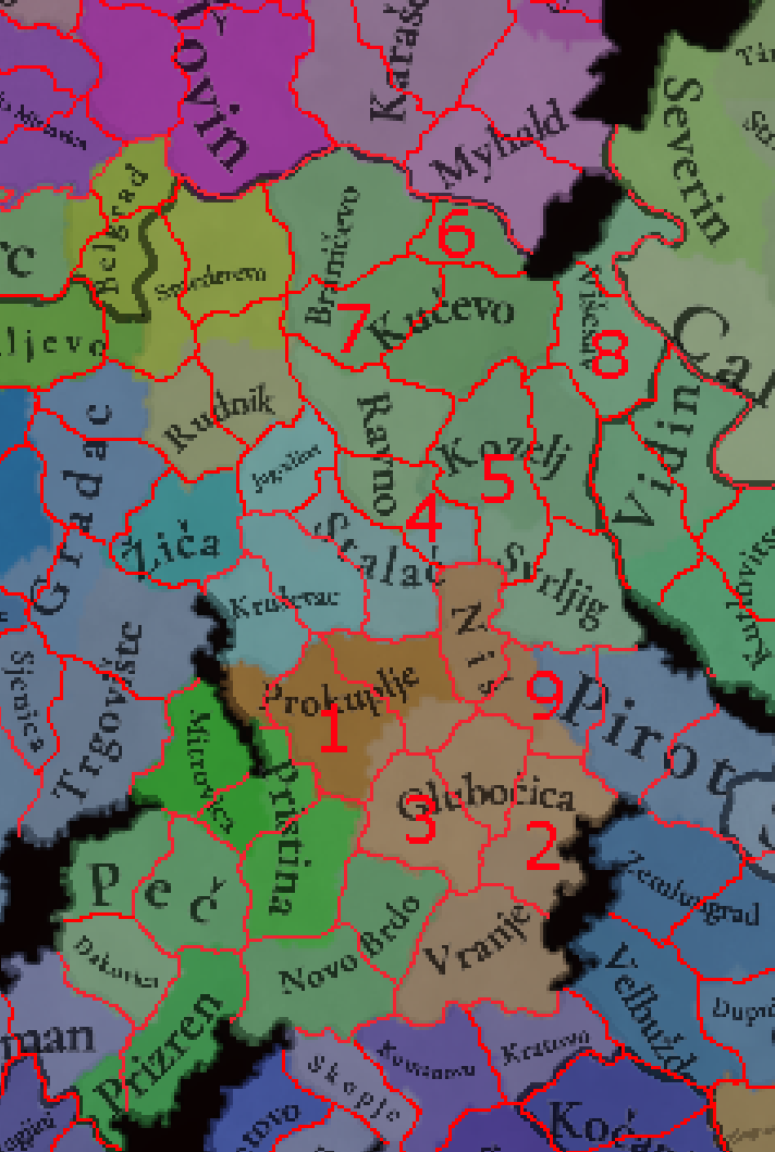
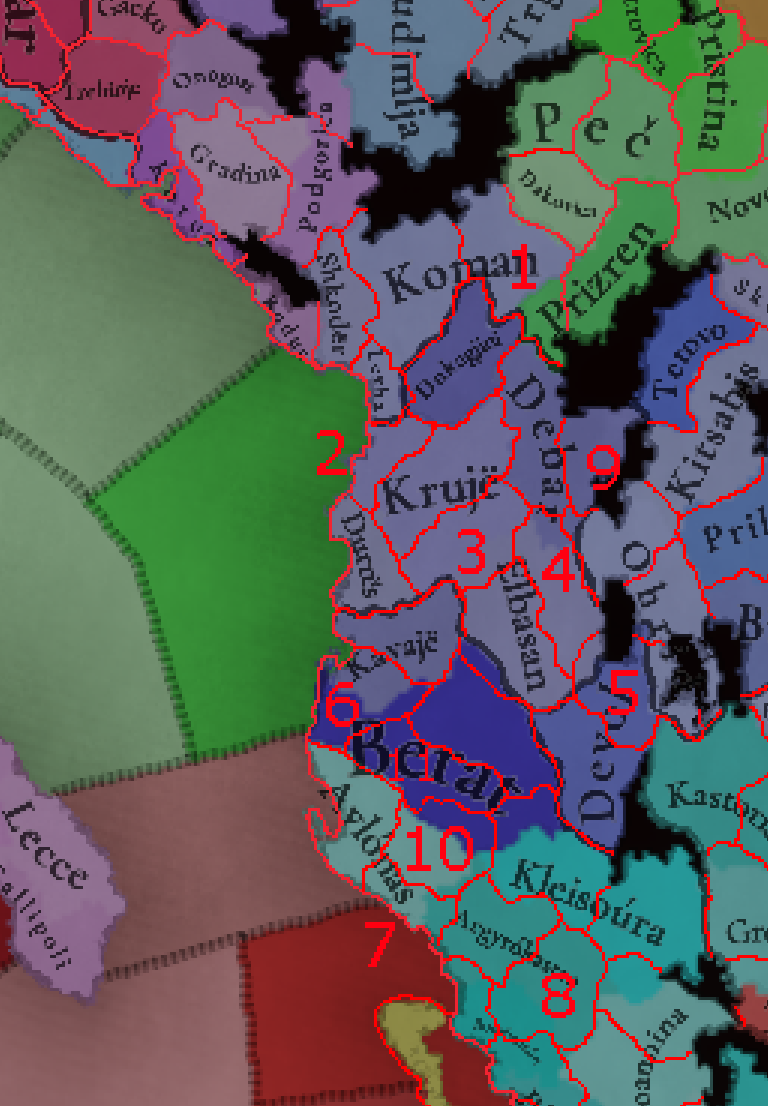
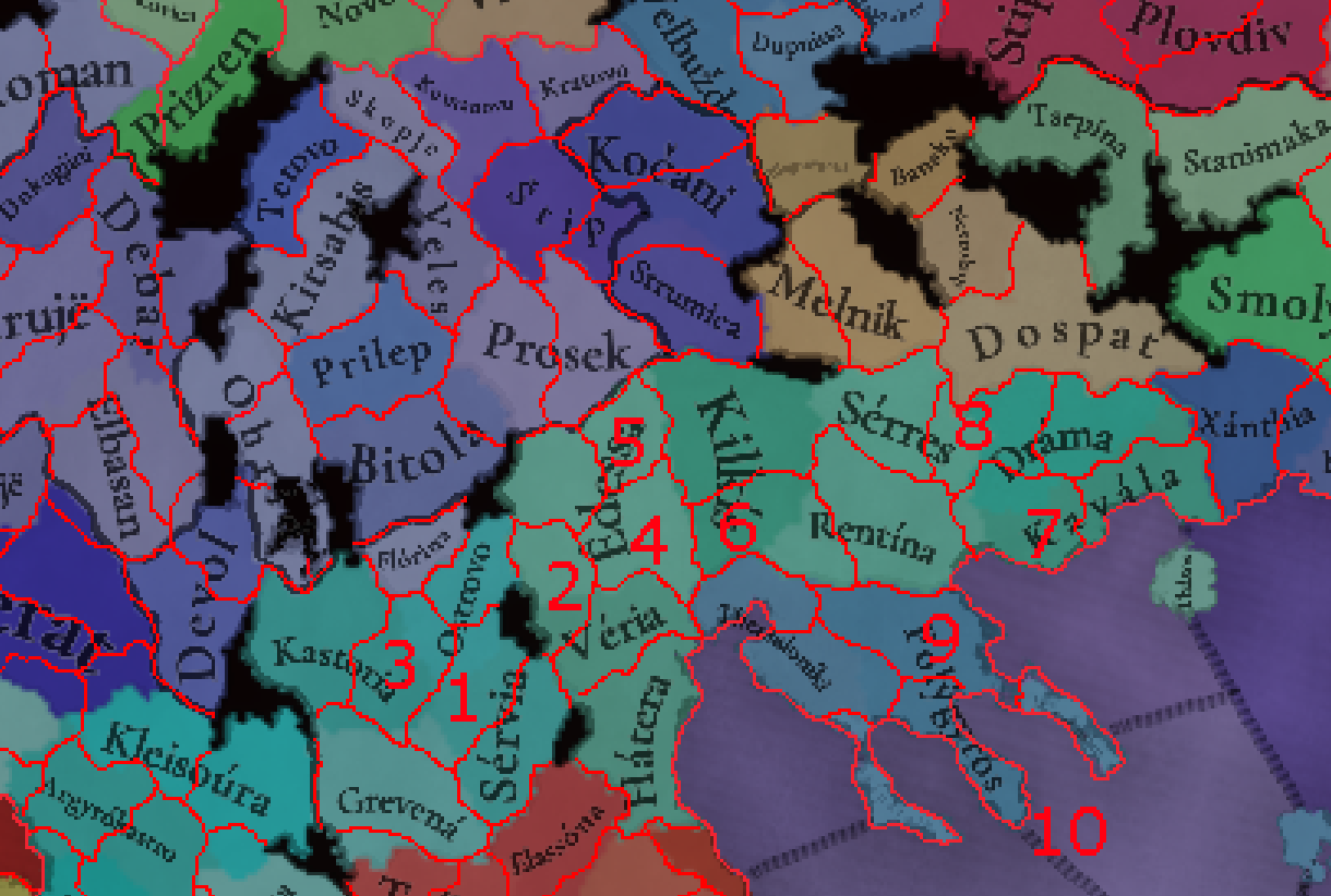
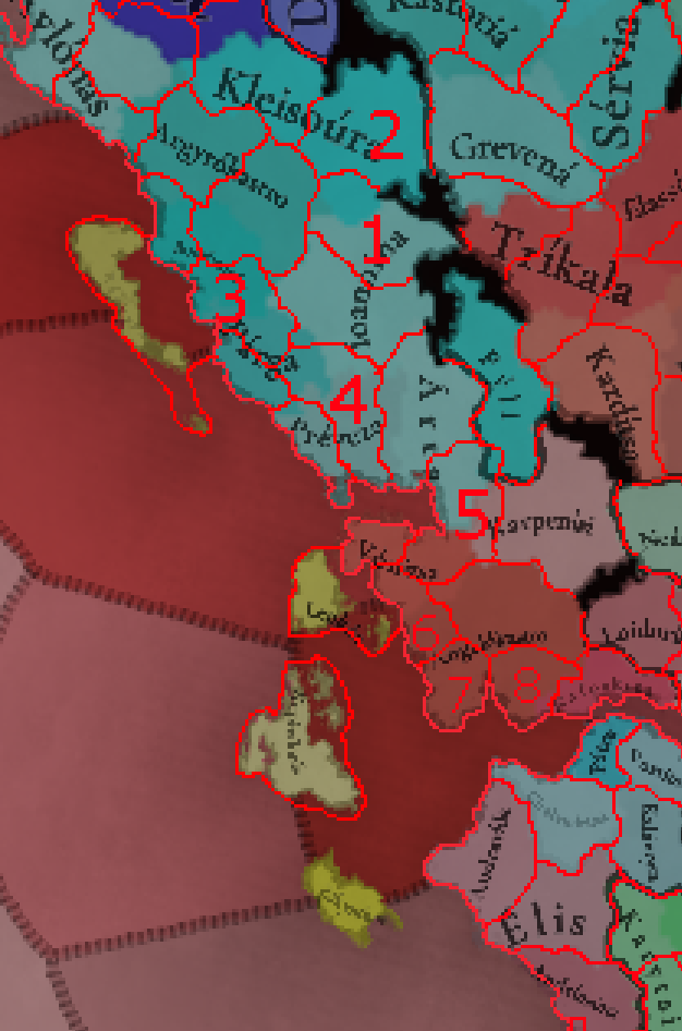
So finally posting my Balkans proposal (hopefully still in time
@Pavía ?)! I apologize that not all of it is in the same detail as the early parts- extremely busy schedule the past few months, but I hope it is still helpful! For context, I have a lot of experience in Balkan EU4 modding, being a developer on Beyond Typus most responsible for it, as well as helping the Voltairre's Nightmare and some smaller mod devs here. particularly on their map of Serbia
I also have to first commend the Tinto team Balkans work, it is clearly done with a lot of love and attention, missing a lot of easy mistakes mods frequently fall into, such as adding cities that only became important much later on. A lot of locations have their proper medieval names as well, really cool to see!
General goals:
- represent independent (or highly autonomous) polities
- represent historical borders and places that had different owners from nearby locations, particularly in 1337, and particularly if those are exclaves
- represent major cities not yet represented on the map, as long as they were at least somewhat significant during this period
- represent different terrain and create geographical situations that favor historical outcomes - i.e. certain borders through adjacencies, protecting locations from being too close to other borders etc. Related to this, representing different raw goods - i.e. if two parts of a current location distinctly focus on mining and grain respectively
- reduce the size of locations overly large compared to their neighbours or change very ...ugly looking location borders
- have locations where ethnic minorities form majorities or significant minorities
- offer interesting alternative history options
I have set different priorities for the locations based on how necessary I think their inclusion is - you will find that this is weighed towards the higher values, which I feel is somewhat logical - I wouldn't be proposing locations I think are fully unnecessary. As usual, I'm showing the whole overhaul first and then focusing on the details (as you can see, I skipped on doing Transylvania and parts of Central Hungary)
Dalmatia
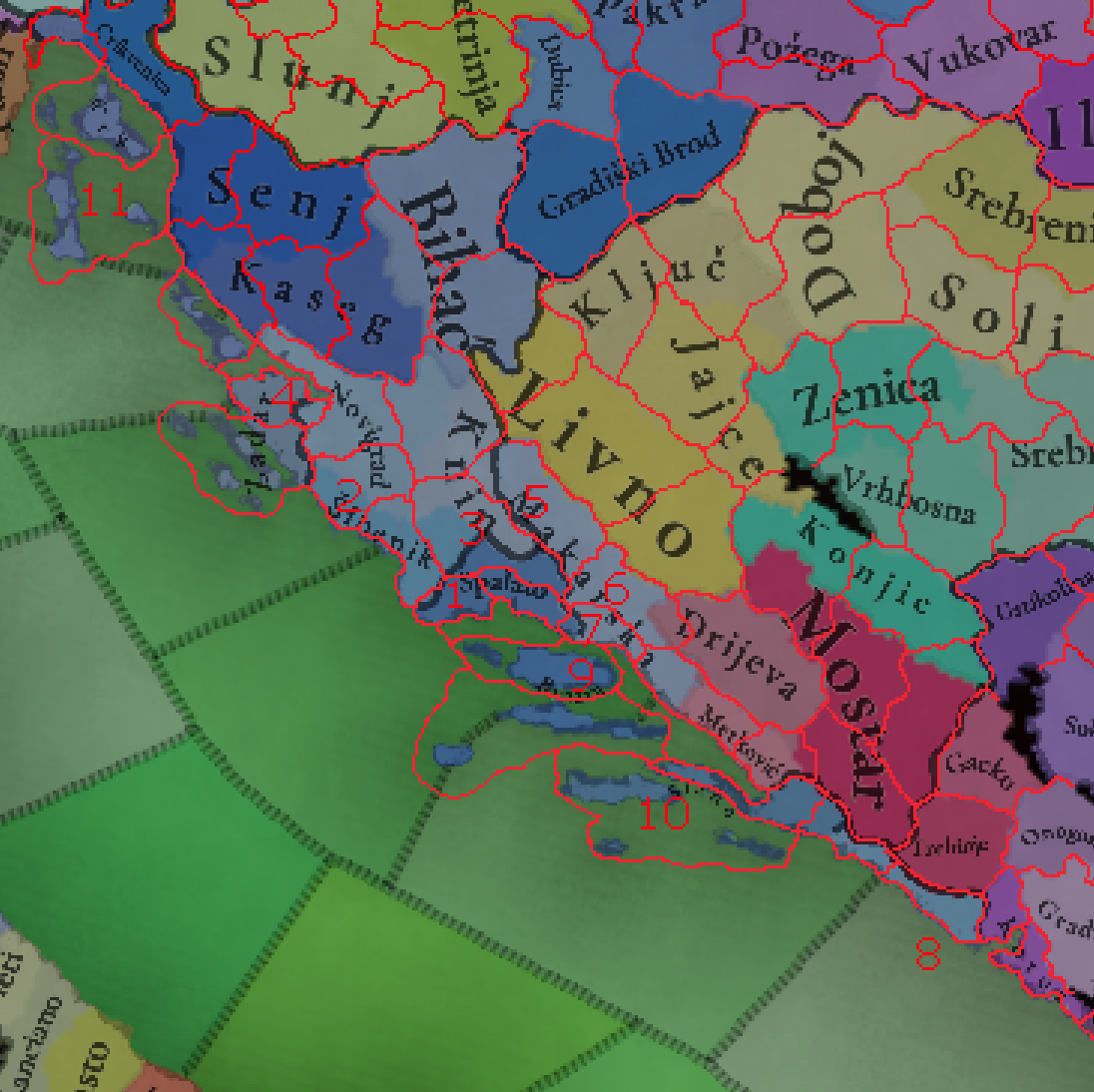
The goal with Dalmatia is to increase the separation between the wealthy coastal cities and its mountainous hinterlands, which nonethless still hold great strategic importance. Representing the old Croatian counties better is a nice bonus
Knin location has been shifted north towards its more natural position, also separating the coastal Novigrad from Bosnia
1.
Trogir
Small city with a long history, one of the first Venetian possesions in Dalmatia. Overshadowed by Split and Šibenik, but still wealthy and prominent, in 1337 it even had certain autonomy under the Šubić family and was an administrative center under Venice. One of the less important locations suggested here due to its size and already being covered well enough by Split, it would split (heh) the towns of Split and Šibenik with a more rural location between them
PRIORITY: Medium
Tradegood: Fish, fishing was the most important economic activity historically. Fruit, Legumes and Olives were all also produced
2.
Bribir/Skradin
Bribir is one of the ten original counties of Croatia, and was the key holding of the Šubić family, particularly prominent around 1337. The fortress of Bribir itself was not as important anymore, with the major towns being Ostrovica Fortress and Skradin. Given the complex dealings of the Šubićs with Venice, Hungary, Serbia and Bosnia, they could easily warrant a tag represented in this location
PRIORITY: High
Tradegood: Fruit, nothing specific found, representing the production elsewhere in Dalmatia
3.
Klis
Covering the hilly inland parts of Dalmatia before you get into the actual moutains, Klis was an important fortress fought over between Venice, Hungary and the Ottomans. Here it would serve the same function - a fort there could protect all of the coastal cities, or keep them all in check. While I gave it Medium priority, that's merely due to resulting size concerns for the coastal city locations, otherwise this is a very tactically important location
PRIORITY: Medium
Tradegood: Wine, no other Dalmatian location has it yet and the region is a notable producer
The tradegood of Split can be changed to Wool, grown in the area since the days of Diocletian - though fishing is important as well, so your placement of Fish isn't wrong
4.
Nin
While this would make both Nin and Zadar very small, I believe Nin deserves to be added, as one of the early Croatian capitals and the seat of the Croatian bishops. Nin was also still a decently relevant city until its destruction in 1646, being a Venetian administrative center until the fall of the republic. Another case where the priority would be higher if the sizes were better
PRIORITY: Medium
Tradegood: Salt, the Nin saltworks date to 1423 at the latest. If Nin isn't added. Zadar's tradegood should definitely change to Salt instead
Biograd na Moru was also an important town (perhaps the most important in the Kingdom of Croatia in its later period), but after being destroyed by Venice in the 1100s it lost most of its prominence to Skradin and Zadar, so I would simply include it into the Skradin location
5.
Sinj
Further diversification of the inland locations, Sinj also played an important role in the regional wars and was another important Šubić possesion, and later in the period was the last Ottoman fortress in Dalmatia
PRIORITY: High
Tradegood: Horses, Sinj is best known for its famous jousting and horseriding festival, Sinjska Alka, continously held until late in the period
6.
Imotski
Imota was one of the early Croatian counties, and Imotski remained and important town through the period. Makarska going so far inland is also very odd and doesn't make much sense. If you want to add less locations, Sinj and Imotski could be merged, with either of them working as the name.
PRIORITY: Very High
Tradegood: Livestock/Wool, a largely livestock keeping region, though some grains and Wine are also grown in Imotsko Field
Makarska should be renamed to Mokro, its medieval name. Wheat is a poor fit as the tradegood, and should be replaced by Fish or Olives, the actual main products
Metković was not a particularly prominent town during this period - I would replace its location with that of Ploča (today Ploče), but also representing Neum. As you may be able to tell, this would mean that it would de-facto serve as the representation of Bosnia's later sea access. In 1337, it would be owned by Ragusa (multiple options with so many owners in such a small area, but I went with Ragusa as a buff to them and to make their historical ceding of Neum to Ottomans make sense. They also had significant influence in Ploča as well). Would also include the ancient town of Narona
7.
Omiš
A very important town and fortress through the period, this location can also be used to represent the Poljica Republic, a small autonomous community of villages that swore fealty first to Hungary and then to Venice and lasted through the period. Omiš itself was not a part of it, but it lay just outside and most of the villages in the area were, so I consider it an acceptable simplification. The city of Omis itself was known through the period for its corsairs, which attacked Venice and Ottomans alike
PRIORITY: Very High
Tradegood: Fish or Wine, both fit well
Now, I would separate Ragusa as a province separate from the rest of Dalmatia, due to its unique history under the Republic of Ragusa.
Slano should be replaced by Ston - a much more relevant city through the period. Ragusa has just purchased Ston and the Pelješac peninsula from Serbia in 1333, so it would still be overwhelmingly Serbian and Orthodox at the game start. SLano (as its name implies) and Ston both had notable saltworks, so the tradegood of the location should be changed to Salt
8.
Cavtat (Konavli)
Despite the small size, this is probably the most important addition in Dalmatia - the small but very wealthy county of Konavli was a key possesion of both Serbian and Bosnian rulers before it was acquired by Ragusa. In 1337, it was still owned by Serbia (only becoming Ragusan in 1426), thus having a different owner than shown here and for much of the period, and still being predominantly Serbian Orthodox. Cavtat is the successor to Epidaurum, the predominant Greek/Roman city of the region.
PRIORITY: Essential
Tradegood: Fruit There are so many mentioned as produced: Wool, Fruit, Olives, Wine, Horses, Fish etc. Looking at the balance of goods in Dalmatia and the number of different fruits named, I would assign it Fruit
The tradegood of Brač should be Marble - the main tradegood of the island since the Roman times have been the marble quarries - though not quite as famous Hvar Marble mentioned below. Olives, Fish and Livestock (most notably goats) are also major tradegoods of the island
As for the Dalmatian islands, Brač, Pag and Krk you included are definitely the most important ones - however, both the southern and northern groups can see at least one addition, with the south having another potential one:
9.
Hvar
Covering the islands of Hvar and Vis (leaving Brač and Šolta under Brač), Hvar/Lessina was of a very similar importance to Brač
PRIORITY: High
Tradegood: Marble, it is one of the most notable Marble quarries in Europe since antiquity, and very active in the period as well
10.
Korčula
Korčula is currently a part of a location owned by Ragusa, which should not be the case - it was only ever briefly a part of the Republic of Ragusa in this period. The eponymous city of Korčula was the most notable one on the Adriatic islands, being the seat of a bishopric and a notable shipbuilding and stonecutting center, and also a possible birthplace of Marco Polo.
PRIORITY: High
Tradegood: Stone, as mentioned stonemasonry was a major industry, but the stone was of lower quality than the Marble of Brač and Hvar
11.
Cres
Covering the islands of Cres and Lošinj, Cres was less important than the other new island locations I propose (and was far more directly integrated into Venice), but it did have its own statute dating back to 1332.
PRIORITY: Medium
Tradegood: Medicaments, sage is one of the main products of the island. Olives are also important, and if Apiculture/Bees is added, it would be the natural tradegood as Cres honey is considered to be among the highest quality in the world
This division of the islands would also respect the Venetian administrative division of Dalmatia, with all of the Venetian administrative centers being included, apart from the small Rab, which seems unlikely to be added given your policy on islands
With this, I hope to make Dalmatia both more historically accurate and more interesting to play around in
Bosnia
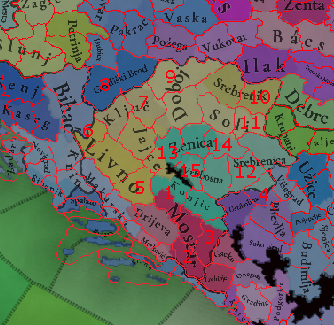
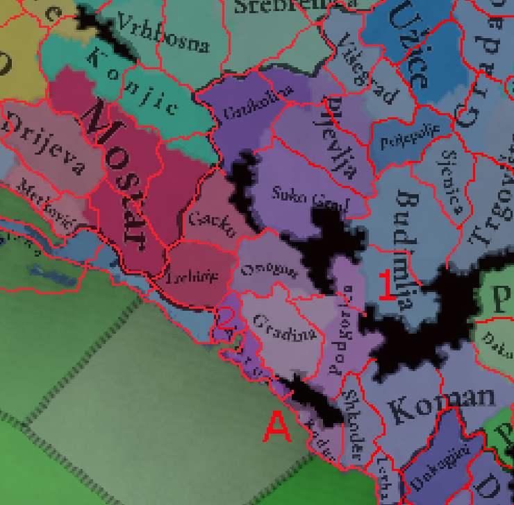
Out of all the Balkan regions on the map, Bosnia seems to have gotten the worst deal - its density is far lower than that of most other Balkan regions shown, and several of its most important cities are missing. While Bosnia isn't the wealthiest part of the Balkans, it still had a powerful kingdom soon after the start of the game and a cultural golden age under Ottoman rule, and its complex feudal and later administrative borders could definitely have better representation - as do the Bosnian cities, as Bosnia has always been a rather decentralised region, full of many smaller cities rather than a few large ones - at least until the 20th century. The full proposal here would almost double Bosnia's density, yet it would still be lower than that of Dalmatia on the original map!
1.
Rama
Perhaps the most important location missing in Bosnia, Rama (today Prozor) was one of the most important Bosnian counties and a fortifited city. Its inclusion would also fix some rather awkward (from both a geographical and historical perspective) borders of Mostar and Konjic. Rama was also the last city of the Bosnian kingdom to fall to the Ottomans, and the "King of Rama" was a title used by Hungarian kings. The town of Prozor, the seat of the county, was a large fortress and an important trading center
PRIORITY: Essential
Tradegood: Fruit, this is one of the nicest parts of Bosnia by relief and weather, and the traditional agricultural product of the region is fruit, plums in particular
Mostar as a name appears only in the 1470s, though the town existed before that. The most important city in the region in the Middle Ages was Blagaj - so you could name the location Blagaj and add an event changing it to Mostar later. Speaking of the same location, while Hercegovina does have history of Olive growing, it was never particularly significant - Mostar can keep the Olives as a nod to it, but could also be changed to a more appropriate tradegood like Stone or Wool
2.
Počitelj
Representing Počitelj and other numerous towns and forts south of Mostar (Stolac, Hutovo etc), this adds further depth to the area by further separating Mostar/Blagaj from the sea and splitting its large location. Počitelj was the seat of the Dubrava county and bishopric and an important fortress and strategic point connecting Bosnia to the sea.
PRIORITY: Very High
Tradegood: Wild Game, Hutovo Blato is the most significant hunting ground in Bosnia and has been well known for it already in the 19th century
3.
Nevesinje / Vinčac
Same as above, but for eastern Hum, this location covers the counties of Nevesinje and Dabar. While Nevesinje (or Vinčac as it was called at the time, modern Vjenčac) was a prominent trading center (especially with Dubrovnik) and a county since early medieval times, I still see the area in general as being somewhat less wealthy than the Počitelj one, hence the slightly lower importance
PRIORITY: High
Tradegood: Wool, a significant product of Hercegovina and Nevesinje in particular. Lumber is also an important product
I would REALLY love to also fit Bileća, as a prominent county and town with similar importance to Gacko, but I just don't see a clean way to do it.
Stone is probably fine for Gacko, but the location is home ot a large Coal deposit - though one that was not exploited until modern times, and is still underdeveloped. It would perhaps be odd to give it Coal at this time.
The towns of Foča, Goražde and Ustikolina are quite close to one another, and were of similar importance in medieval times, however Ustikolina has since become the least important one by far, especially compared to Foča, so I would replace the Ustikolina location with Foča/Hotča (medieval spelling), and ideally split Goražde into its own location, thus
4.
Goražde
As explained above, important market town and fortress, today best known for its status as a near enclave. Woul also include Samobor, an important fortress of the Kosača and Hranić families. Would be nice to split it off Hotča/Ustikolina, but its not as necessary as many other additions here
PRIORITY: Medium
Tradegood: Medicaments, the area is well known for a number of medicinal herbs grown (particularly around Čajniče). Wild game and Fish are also important products
5.
Županjac
Modern Tomislavgrad/Duvno, this covers the southern parts of the current giant Livno location. This is an old city, dating back to ancient Roman Delminium, and was an administrative center under the Ottomans as Županj-Potok
PRIORITY: Medium
Tradegood: Livestock, the main tradegood of the Duvno region
6.
Pset
Covering modern towns such as Grahovo and Drvar, this is a very mountainous and less densely populated area, Pset was still an important county centered on the eponymous castle (modern Bosanski Petrovac) and further balances the sizes of Bihać and Livno
PRIORITY: High
Tradegood: Wool, common tradegood for Bosnian highlands, and Petrovac is well known for its carpet weaving
7.
Zvečaj (Banja Luka)
Another very import location currently missing - Banja Luka is the modern capital of Bosnian Serbs, and while it did not exist under that name in the middle ages, there were multiple prominent castles and towns in its area then, most notable among them Kotor, Vrbaški Grad and Zvečaj - I went with the last one as its closest to the modern city. Under the early Ottoman rule already, Banja Luka became one of the capitals of the Sanjak of Bosnia
PRIORITY: Essential
Tradegood: Wine, very fertile river valley and one of the wealthier parts of Bosnia, on the border between two wine regions. Livestock is also an option, representing trappist cheese made in the region later in the period
8.
Kostajnica
This part of modern Bosnia was only ever briefly a part of it in the Middle Ages, being solidly a part of Croatia. Kostajnica was an important fort and trading center.
PRIORITY: Medium
Tradegood: Fruit, fertile area and name comes from chestnuts
With this, Gradiška can better match the borders of the Lijevče region it is a part of, and its tradegood should become Wheat
9.
Dobor (Modriča)
Doboj is currently very large and makes some borders (such as the Hungarian and much later Austrian control of northern Bosnia) difficult to portray. This is solved by splitting off its northern parts along the Sava river into Dobor (modern Modriča)
PRIORITY: Essential
Tradegood: Wheat, a fertile agricultural region - the remaining Doboj location would better match Fruit or Legumes
Soli should have its tradegood changed to Salt, as its name implies - Soli (modern Tuzla, also meaning salt) has been a major salt mine for centuries and one of the main sources of Bosnia's wealth in the Middle Ages
10.
Bistrica (Bijeljina)
One of the most baffling decisions in the current map of Bosnia is the lack of any representation of Podrinje, the area of Bosnia along the Drina river - notably because it was also owned by Serbia for much of the 15th century while the rest of Bosnia was its own kingdom. To further support 13th century and 18th century borders, I suggest adding two locations to Podrinje (see Zvornik below), but even just one would greatly improve the early period accuracy as well as geographical/cultural regions. Bijeljina (known as Bistrica in the middle ages) was a an important trading town.
PRIORITY: Essential
Tradegood: Iron, iron smelting is mentioned in Bijeljina since early Medieval times. Coal and Salt mines are also present in the region
11.
Zvonik (Zvornik)
As mentioned above, this location helps portray historical borders, while also representing the important Zvornik Fortress, a sanjak center during Ottoman times. If you want to add less locations, I would merge Bistrica and Zvonik under the Zvonik location
PRIORITY: Very High
Tradegood: Clay, significant kaolin deposits near Zvornik. Lead and Zinc mines were also present in the region in Middle Ages
12.
Olovo
Important medieval lead mining town (as the name implies), which also helps represent the possesions of the Pavlović noble family. During the middle ages, most of its population were Saxon miners
PRIORITY: Very High
Tradegood: Lead, obviously
13.
Travnik
Another one that seems very obvious to me, as Travnik is the most notable capital of Ottoman Bosnia. Travnik was also important in medieval times, as the fortified seat of the county of Lašva
PRIORITY: Essential
Tradegood: Wool, common tradegood in Bosnia. Gold is an interesting option, as Lašva is a goldbearing river, but I am not sure that was that economically important
With Salt being moved to its proper location in Soli, Copper is a more fitting tradegood for Vrhbosna, given the Copper (and Lead) mines in the region.
The last two locations are less important, but would help flesh out the rich heartlands of the Bosnian kingdom:
14.
Bobovac
Important castle and one of the capital of Bosnia (alongside nearby Sutjeska), as well as a settlement of Saxon miners.
PRIORITY: Medium
Tradegood: Gold, a gold and lead mine was located here (so Lead is a possibility as well)
15.
Fojnica
The royal mint of the Bosnian Kingdom, Fojnica was surrounded by numerous silver mines that made it one of the most prosperous cities of
PRIORITY: Low
Tradegood: Silver, as noted above
Montenegro, Kosovo and North Macedonia are all quite small, but I have a couple suggestions for each
Montenegro
1.
Brskovo
The Montenegrin hinterlands currently feature some oddly shaped locations, with there being plenty of space for the pass between Budimlja and Podgorica to become a new location of Brskovo (modern Mojkovac), an important fortress and silver mining town that was living its golden age in late 13th and early 14th century, with the majority of the population being Saxon miners (who I mentioned in a previous post should be added to basically every mining location and town in Serbia)
PRIORITY: Very High
Tradegood: Silver, as noted above
With this, Gradina/Cetinje can also be reshaped to better match the borders of the Prince-Bishopric of Montenegro, independent from Ottoman rule for much of the period
A:
Replace Budva with Bar (or add Bar)
The location of Budva does not actually contain Budva - the much better location name here is Bar, an important port until today and the seat of the catholic Archbishops of Bar, the most important catholic clergy in Serbia. Splitting the location into the two is an option, but that seems very difficult given the sizes.
2
. Risan / (Herceg) Novi
I would however add a small location to the northwestern part of Montenegrin coast, to represent Herceg Novi, a major port city founded in the 15th century by the ruler of Hum/Hercegovina, and which was the most important port of Montenegro for much of the period. If you want to avoid having a location named after a settlement that explicitly didn't exist in 1337, you could call it Risan and have an event for its founding.
PRIORITY: High
Tradegood: Medicaments, Risan has been known since Greek and Roman times for medicinal herbs, and Herceg Novi is best known for its mimosas, so Medicaments seems like the best tradegood here - though others like Olives or Salt are also possible
Kotor had significant autonomy under Serbian rule, with its noble families basically being allowed to run it as an independent republic that competed with Ragusa and Venice - there is a strong argument to be made that it should be a vassal republic tag.
Horses and Wheat are odd tradegoods for the Montenegrin highlands - I would replace Budimlja's and Soko Grad's tradegoods to Livestock and Lumber respectively. Similarly, Fruit or Livestock fits Cetinje better than Clay, and Wheat would be a good fit for Podgorica, which has the most significant agricultural land in Montenegro
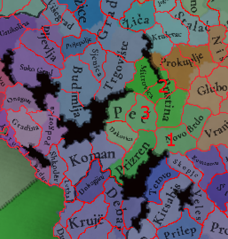
Kosovo
Mitrovica didn't develop as a major town until late 19th century- the center of Northern Kosovo (and one of the most important political centers in Serbia) was the nearby town and fortress of
Zvečan. The location also makes more sense being included in the Ras area than in the Kosovo one.
1.
Lipljan/Nerodimlje
The Roman Ulpiana, this location would represent southeastern Kosovo, which was at the time the favourite leisure area of Serbian kings, with many palaces like Nerodimlje, Štimlje, Pauni and Svrčin surrounding the artificial Svrčin Lake. The most important city in the area today is the later founded Ferizaj/Uroševac
PRIORITY: Very High
Tradegood: Fruit, to represent Kosovo's production of it
Fiber Crops is an odd tradegood for Priština, Wheat fits its agricultural production betterm but the best tradegood is likely Coal, given its massive reserves here, already represented in EU4
2.
Vučitrn
A bit harder to fit in, but very important. Vučitrn has been a city since medieval times, and during centuries of Ottoman rule it was the seat of the Vučitrn Sanjak, which covered almost all of modern Kosovo, so it seems like an obvious inclusion
PRIORITY: Essential
Tradegood: Fiber Crops, moving the current tradegood from Priština. In modern times, its best known for its potato production
The current division of tradegoods in Metohija is odd - wine is given to Đakovica, which does not produce it nearly as much as either Peć or Prizren, both of which should get Wine instead, while Đakovica gets Livestock (representing the numvrous well known cheeses of the region). Both of the other cities have good alternative tradegoods, with Fruit for Peć and Livestock for Prizren as well
3.
Destinik (Klina)
Mostly added to help balance the sizes given the additions to Kosovo, as well as to add an explicitly rural location to Metohija (whose 3 locations are its 3 major cities). This area includes numerous medieval Serbian monasteries (much like the rest of Kosovo & Metohija)
PRIORITY: Medium
Tradegood: Wheat, generally fertile part of the region
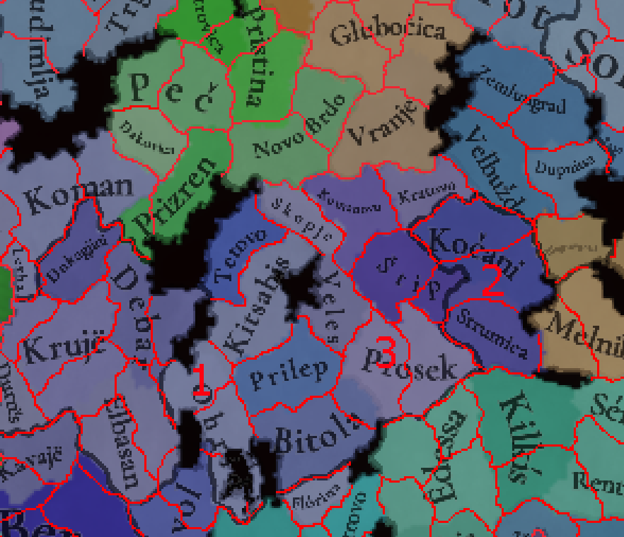
North Macedonia
1.
Struga
Small fishing town on the shore of Lake Ohrid, added to reduce the size of the Ohrid location
PRIORITY: Medium
Tradegood: Fish, as per above
2.
Radoviš
Kočani is quite a bit larger than nearby locations, and Radoviš was a notable settlement and mining town in the middle ages and under Ottoman rule, with 3000-4000 people
PRIORITY: High
Tradegood: Copper, the Copper and Gold mine of Bučim
3.
Dukena
Representing the wine-rich Tikveš region, the medieval village/town of Dukena developed into the notable city of Kavadarci under Ottoman rule. The location also includes the important ancient city of Stobi and the town of Negotino/Antigonea
PRIORITY: High
Tradegood: Wine, Tikveš is very well known for its wine production
I would change the tradegood of Kratovo to Silver, for which it is most known for (though gold, Iron, Lead and Copper were all also mined). Kratovo should also have a small Jewish community, in addition to a Saxon and Dalmatian one. I would then move its Iron to Kumanovo (more accurately known as Žegligovo at this time)
Serbia
Obviously the region I know the best about, so I'm excited to make suggestions here!
Before I get to that, I have to note that the borders of Serbia are slightly wrong - Florina/Lerin had already fallen to Serbia before 1334, when Dušan appointed a commander for it (I've seen some sources mention 1331 as the year of conquest). Similarly, Strumica was kept by Dušan in his 1334 treaty with the Byzantines (belonging to an independent state of a Serbian lord Hrelja Ohmućević before that - Hrelja still had territory in southwest Bulgaria and eastern Macedonia as a vassal of Serbia). In the north, Belgrade and Debrc (and Zaslon/Šabac if added) should be owned by Serbia, as the border was estabilished on the Danube after 1335.
"Smrt Sirgijana je poremetila dalje Dušanove planove, pored toga mir je bio potreban i Dušanu i Androniku III, buduću da je Dušan morao da zaustavi napad Ugra sa severa, dok je vizantijski car morao da se posveti restauraciji carstva na teritoriji kontinentalne Grčke. Tako su se Dušan i vizantijski car susreli na reci Galik, blizu Soluna 26. avgusta 1334. godine i tamo sklopili mir, a po sporazumu Dušan je vratio neke gradove, a zadržao je Prilep, Ohrid, dva najvažnija osvojena grada, kao i Strumicu i neke manje osvojene od 1332. do avgusta 1334. godine.
Kralj Ugarske Karlo Robert, iskoristio je Dušanov boravak u Vizantiji da napadne sa severa Srbiju i stigne do Žiče.[127] Kada je Dušan saznao za napad Ugara sklopio je mir sa Vizantijom i krenuo sa vojskom na sever prema Spasovom domu u Žiči, ali Ugri nisu želeli da se susretnu sa glavninom srpske vojske koju je vodio kralj Dušan i povukli su se preko reke Save.[137][127] Prema opisu Danilovog nastavljača:
„Kada [Ugri] čuše istinu da prilazi gospodin kralj [Dušan] i kako protiv njih hoće se boriti, svi oni u jedan čas smetoše se... i počeše bežati … I kada su došli na reku zvanu Sava, i tu nemaše nijednog spremljenog [sredstava], u njemu da bi mogli preći takvu reku, ni pristaništa ne znajući gde mogu isplivati, počeše ulaziti u nju zajedno. I Gospod podiže ruku na njih ..., i voda ih potopi, a malo od njih se spase od takve ljute smrti.” (Danilov učenik)[138][139]
Verovatno između početka novembra 1334. i kraja januara 1335. godine ugarska vojska prelaskom Save je izgubila mnogo vojnika, a do pravog vojnog okršaja sa Dušanovom vojskom nije ni došlo i izgleda da su Srbi zadržali teritoriju južno do reka Save i Dunava, sa Beogradom.[140]
Pored domaćih vojnika iz Srbije, u Dušanovoj vojsci značajni su bili strani plaćenici. Zanimljivo je da je imao poseban odred od nekoliko stotina plaćenika Germana kojima je od 1336. godine do pred kraj života cara Dušana vođa bio Palman Braht."
"The death of Sirgian disrupted Dušan's further plans, in addition Dušan and Andronikos III needed peace, in the future Dušan had to stop the Ugri attack from the north, while the Byzantine emperor had to devote himself to the restoration of the empire on the territory of continental Greece. Thus, Dušan and the Byzantine emperor met on the river Galik, near Thessaloniki, on August 26, 1334, and made peace there, and according to the agreement, Dušan returned some cities, but kept Prilep, Ohrid, the two most important conquered cities, as well as Strumica and some less conquered from 1332 to August 1334.
King Karlo Robert of Hungary took advantage of Dušan's stay in Byzantium to attack Serbia from the north and reach Žiča.[127] When Dušan found out about the Hungarian attack, he made peace with Byzantium and marched with his army north towards Spas's home in Žiča, but the Hungarians did not want to meet the main body of the Serbian army led by King Dušan and retreated across the Sava River.[137] ][127] According to the description of Danilo's successor:
"When [the Ugris] heard the truth that Mr. King [Dušan] was approaching and that he was going to fight against them, they all turned away at once... and started to run away... And when they came to the river called Sava, there was no one prepared there either [means], in it so that they could cross such a river, not even knowing where they could swim, they began to enter it together. And the Lord raised his hand against them ..., and the water drowned them, and few of them were saved from such an angry death." (Daniel's disciple)[138][139]
Probably between the beginning of November 1334 and the end of January 1335, the Hungarian army lost many soldiers by crossing the Sava, and a real military clash with Dušan's army did not even take place, and it seems that the Serbs kept the territory south to the Sava and Danube rivers, with Belgrade.[ 140]"
In addition to domestic soldiers from Serbia, foreign mercenaries were important in Dušan's army. It is interesting that he had a special detachment of several hundred German mercenaries whose leader was Palman Bracht from 1336 until the end of Emperor Dušan's life."
Included the last part there to note that Palman Bracht should be included as a character at the court of Serbia!
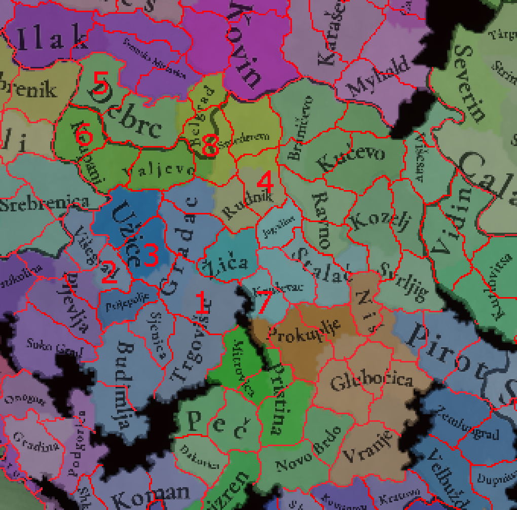
West Serbia
1.
Brvenik
The current Ras/Trgovište location is very large and extends far too much to the north, including regions not really under its influence. This can be fixed by adding Brvenik, a notable castle near today's town of Raška, as well as perhaps a wasteland for the Golija mountain, much of which is still uninhibited today. Brvenik would also include the notable town of Ivanjica, and would have Catholic Serb (the presence of several Catholic villages is noted), Saxon and Dalmatian (Ragusan)
PRIORITY: Essential
Tradegood: Lead, mined in the Koporić mine and Ostraća mines close to the castle. Other possible tradegoods include Iron, Silver and Wool
2.
Jagat / Banja
Pljevlja currently crosses the Serbian/Montenegrin border and Višegrad crosses the Bosnian/Serbian one, and while modern borders aren't particularly important, it would be still nice to represent the Polimlje of Serbia as separate,The most notable town in the area was Banja, near modern Priboj, while the most important fortress was Jagat (today right on the border with Bosnia), which controlled key passes and trade in the region
PRIORITY: Medium
Tradegood: Lumber, another case where the tradegood also helps represent wider regional production
3.
Požega
An important trade post and town since the middle ages, including Požega would further help balance the sizes in the area and increase the diversity of goods - while also representing the terrain more characterized by hills and river valleys rather than mountains. Požega succeeded early medieval fortifications of Dresnik and Megiretus in the region and was an important trading center and Ottoman administrative center . The location would also include Arilje, a major center of wool and Fruit production, so I would represent one of these - probably fruit as the raspberries from the region are one of the biggest sources in the world, though I'd not to the famous Arilje wool by adding a Sheep building at the start.
PRIORITY: Very High
Tradegood: Fruit, as mentioned above this area is the most important raspberry growing region in the world
4.
Kragujevac / Borač
Currently, Gradac/Čačak extends too far to the north, and Rudnik extends too far east - its influence did not really reach to the Morava river. In addition to this, one of the most important cities in Serbia through much of the period (and its capital in the early 19th century), Kragujevac, is not represented at all. This can all be solved by moving Rudnik west, freeing up space for Kragujevac, representing the heartlands of Šumadija. As Kragujevac was first mentioned only in 1476, you can also instead have the location be named Borač, after Borač na Kršu, an important fortress and medieval county center (near modern Knić). The location would also include other important fortresses in Čestin and Srebrenik (the last of which was also a silver mine).
PRIORITY: Essential
Tradegood: Livestock, though Silver is also a possibility due to the Srebrenik fortress and mine
Belgrade location should be much smaller - the city was often held by Hungary without basically anything on the south, so a small city province is very fitting here
5.
Šabac/Zaslon
The current Debrc location is very large compared to most neighbors (particularly if additions I propose are taken into account), so I would split it by adding the important city of Šabac, one of the key fortresses of Serbia through the period (known as Zaslon in the middle ages) and the capital of Macva after mid-15th century
PRIORITY: Very High
Tradegood: Coal, rich Coal basin of Kolubara. Could als be Wheat or Livestock
6.
Loznica
Krupanj is smaller than Debrc, but can definitely see a split - and Loznica was the most important town in the region for most of the period, as well as administratively separate from the rest of Serbia (and Krupanj), being a part of the Sanjak of Bosnia, even only joining Serbia ~20 years after its independence late in the period. During the middle ages, it was similarly home to many important mines
PRIORITY: High
Tradegood: Copper, representing the Copper and Silver mines in Podrinje, as Kruoanj already has Silver. Wine and Fruit are also produced
7.
Koznik
Splitting the mountainous, mining regions around Kopaonik from the more fertile lowlands of Kruševac, Koznik was an important fortress and mine, remaining so under Ottoman rule (with one of the nearby villages being a major arrow producer for the sultanate)
PRIORITY: Medium
Tradegood: Wine, the area around Aleksandrovac is one of the most important wine growing regions in Serbia
8.
Bukovac (Aranđelovac)
With Belgrade being reduced in size, there is space left to represent the natural region of Jasenica, today a densely populated if not highly urbanized area (it was far less populated and more forested in the middle ages). The major city is Aranđelovac, which was the fortress of Bukovac in the Middle Ages. One of my main reasons for including this location is the very unique tradegood- the Venčac marble of Aranđelovac is celebrated worldwide, even being used (alongside the Hvar marble) in the White House
PRIORITY: High
Tradegood: Marble, as mentioned above
This all also helps add further decidedly rural locations to Serbia, putting some separation between its major cities and diversifying the tradegoods. Along with the additions in East Serbia, it also better shows the division between the wealthier and poorer areas, with a string of smaller locations hugging the Morava (and West/South Morava) and Danube
Tradegood changes:
Sjenica: Livestock, mostly well known for its cheese
Gradac: Livestock, best known for meat products
Žiča: Fruit (or potentially Wheat), fit the very fertile region better than Stone. The nearby Plana mine mined Gold, Silver, Lead, Copper and Iron all
Smederevo: Wine, important wine region
Kruševac: Livestock, Horses are an odd choice here
Jagodina: Fruit, more prominent than Wheat here
East Serbia
1.
Bela Crkva (Kuršumlija)
One of the most important additions in East Serbia, the modern Kuršumlija was, under the name Bela Crkva, the main city and fortress of the region in the Middle Ages. The location divide also separates the mining, mountainous west of Toplica from its agricultural northeast
PRIORITY: Essential
Tradegood: Silver, mined alongside Lead as one of the largest mines in Serbia, especially during Ottoman rule
2.
Surdulica
Glubocica/Leskovac and Vranje are both rather large locations, and both represent mostly the agricultural lowlands alongside South Morava river. The town of Surdulica, known as Inogošte in the middle ages, was a notable Iron mine, making that the natural tradegood. The location also includes Vlasotince, also a medieval settlement.
PRIORITY: High
Tradegood: Iron, as per above
3.
Međeđa (Medveđa)
Further separates the Glubočica location, Međeđa (today called Medveđa) also represent rather mountainous mining regions - most notably, the large Lead and antimony mine of Lece, operating since antiquity.
PRIORITY: Medium
Tradegood: Lead, mined alongside Gold and Silver
4.
Petrus (Paraćin)
One of the smaller locations I'm proposing, Paraćin has for centuries been a part of a tri-city area along Jagodina and Ravno/Ćuprija, no less important than them. It was a major fortress in medieval Serbia and later became an early industrial center, particularly for glass production.
PRIORITY: High
Tradegood: Sand, helping faciliate the local Glass production
5.
Sokolac (Soko Banja)
Probably the most notable omission in East Serbia alongside Bela Crkva, the modern spa town of Soko Banja is home to an imposing fortress called Sokolac or Soko Grad (common name in the region), which served as a major defensive point for Serbia and an early Ottoman administrative center. This would also represent the rather mountainous parts of East Serbia around Soko Banja, as opposed to the more lowland and Timok river valley area around Kozelj/Zaječar
PRIORITY: Essential
Tradegood: Medicaments, Soko Banja has been used as a spa for millenia, and the nearby Rtanj mountain is notable for its herbs and health properties
Kučevo was not a significant settlement until later in the period, and was never more than a small town. The better name for the location is
Železnik, representing the fortress guarding the mines of modern Majdanpek.
6.
Golubac
Another notable omission, Golubac is an absolutely massive fortress, one of the largest and best preserved in Europe. The fortress saw significant military action as well, with great battles against the Ottomans, including one where the famous Polish knight Zavisza Czerny died. The location would also serve to divide the Kučevo/Železnik location into the flatlands and lower hills close to Danube in Golubac and the more hilly/mountainous parts to the south.
PRIORITY: High
Tradegood: Copper, further copper mines are found here. Fish or Livestock are also possible
7.
Ždrelo
A further split for the large Kučevo and Braničevo locations, Ždrelo was the most important medieval town in the region until Golubac was founded, and the oldest alongside Braničevo. Today, its near Petrovac na Mlavi. And while Golubac is definitely less hilly than Železnik/Kučevo, it goes even more so for Ždrelo, which would represent the area of Stig, one of the most fertile and flat areas of Serbia. If Ždrelo isn't added as a separate location, I would include it over Železnik, though keeping the latter's iconic copper.
PRIORITY: Medium
Tradegood: Wheat, a breadbasket of Serbia
8.
Negotin
Not a very important location, as it would make both it and Kladovo/Višesav small, and isn't a notable city until the 18th century, but I'm offering the split, due to Timočka Krajina around Negotin and Ključ around Višesav having very distinct cultures, and Negotin's great importance to the First Serbian Revolt and early modern Serbia. The area is iconic for its Wine production, with Wine being stored underground in the special 'pimnice'
PRIORITY: Low
Tradegood: Wine, as noted above
9.
Izvor (Bela Palanka)
Another location with less importance, modern Bela Palanka was the town of Izvor in medieval Serbia and early Ottoman rule, but was better known as the Roman city of Remesiana under Roman rule. Adding it would offer a further distance between Niš and Pirot and help represent more diverse goods of southeastern Serbia, as well as limit Niš more to the river valley (Izvor, like Pirot, would be a mix of the river valley where most people live, and some quite tall mountains (though those are also represented by the wastelands)
PRIORITY: Low
Tradegood: Legumes, an agricultural region. Livestock is also a possibility
Most of these additions, particularly Izvor, Medveđa and Inogošte, also help further separate the rural areas from the towns of southeastern Serbia, as currently all of the locations there except for Prokuplje have been decently large towns since the 14th century (even if only Niš will likely be one in Project Caesar due to in-game balance)
Additional possible locations include Bovan/Aleksinac between Niš and Petrus (a notable castle and salt storage), Gurgusovac/Knjaževac from Svrljig (a notable city in early modern Serbian history) or keeping Kučevo in addition to Železnik, but I find them less necessary.
Tradegood changes:
Braničevo: Horses, Požarevac is well known for them and Serbia did extensively use tnem, so I'm replacing the ones in Kruševac
Kučevo/Železnik: Copper, this is where some of the largest and oldest Copper mines in the world are
Višesav: Fish, no major mines here, so their main product was fish and caviar from Danube
Kozelj: Livestock, major product of the Timok Valley
Pirot: Wool, best known for its carpets and wool
Niš: Wine, major product of the region, the richest in East Serbia. Fruit is also a possibility, especially due to local Cherries
Glubočica: Fiber Crops, Leskovac is best known for its textiles, though Livestock is also an option
Vranje: Livestock, major product of the region
Ravno: Wheat, I could not find significant mines in this agricultural region
Speaking of Serbia, there should be more farmlands along the Morava river - while some of Serbia's richest and most densely populated regions along the Danube and Sava were far less populated and cultivated in the Middle Ages, that is not the case with the southern parts of the Morava - I would give Niš, Kruševac and Žiča all Farmlands terrain, as well as Priština, Peć and Prizren in Kosovo. On the other hand, more of Šumadija should be dense Forest. Others have mentioned it as well, but I would also expand the Subtropical Climate to more locations in Serbia along the Danube and Morava - again, Niš should really have it, it is even mentioned as an example on the wikipedia page of Subtropical Humid
Building from a previous comment of mine here
"Germans very very important miners everywhere in medieval Serbia - from the current locations, they should also exist in Kruševac (representing the Koznik mines), Krupanj, Kučevo and Rudnik. In addition, Novo Brdo should have a nicely-sized Dalmatian population, representing the Ragusan merchant colony of Janjevo, and small Dalmatian populations in most locations in West Serbia (notably Ras/Trgovište), Užice, Pljevlja, Prijepolje and Višegrad, as well as Rudnik, Kruševac and Niš for the same reason. Niš should also have a small Greek and Jewish minority, and probably be more populated than nearby locations",
all locations with mining tradegoods in Serbia, Bosnia and Bulgaria should have Saxon minorities, all towns of Serbia should have a small Dalmatian Catholic minority and most towns across Balkans, especially in the south, should have a few Romaniote Jews. Orthodox locations in Serbia, particularly in western Serbia, should have some Catholic Serb pops as well, as the Catholic church still had significant influence in the country - and Bar, where the seat of the Catholic archbishops was, should be majority Catholic.
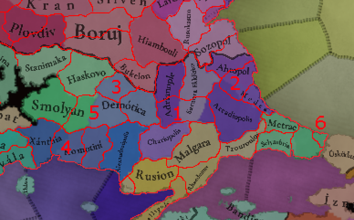
Albania
I would replace the Koman location with the important medieval city and bishopric of
Drivast/Drisht
1.
Kukes
Splitting the large Koman location by representing the Has region of northeastern Albania. There are many notable Copper mines in the region, making that the obvious tradegood
2.
Lac
Representing the Misia region (not to be mixed with the similarly named regiom of Asia Minor), which was during the League of Lezhe held by the powerful Bašić family, a Serbian member of the mostly Albanian league. Lac was also the original home of the powerful Albani noble family of the Papal States.
3.
Petrele/Tirana
Tirana is obviously the capital of modern Albania, but it was not founded until early Ottoman rule. Instead, the nearby medieval castle of Petrele is used as the name of the location, with an event for Tirana's founding hopefully being added. Petrele was an important stronghold of the Kastrioti family, and dates back to Roman times.
4.
Sopot
The medieval name of modern Librazhd, a very mountainous region of Eastern Albania, with notable Iron mines. Sopot was an important place in the middle ages, dating back to at least the 12th century, and would have had a significant Slavic population at this time
5.
Gorice/Korce
Seems like an obvious addition, as the most important city in southeastern Albania for most of the period, being greatly expanded by the Ottomans soon after their conquest of the region. The location has significant Greek and Slavic populations.
6.
Fier
The most important city of the Myzeqe plain, Fier already existed as a Venetian trading post early in the period, and is quite close to ancient Apollonia. The region was held by the noble Mataranga family
7.
Himare
A very culturally distinct region, which was a Greek exclave for centuries and resisted Ottoman conquest far longer than most of southern Albania.
8.
Delvine
The northern center of the powerful Shpata family in the middle ages and a sanjak center under the Ottomans, Delvine was only surpassed by nearby Gjirokaster late in the period
9.
Presolengrad
The medieval name of Peshkopi, this location would split the Albanian parts of the Debar location from the Macedonian ones
10.
Tepelene
One of the most important towns of Ottoman Albania, and the home of the famous Ali Pasha of Yanina
11.
Ballsh
Perhaps the least important location I'm suggesting here, Ballsh is the successor of the ancient Illyrian city of Byllis and the center of the Mallakaster region that would balance the size of Berat location
Also not directly related to Albania, but I would add small amounts of Albanian pops to Hercegovina, Dalmatia and Western Serbia to represent the Mataruge tribe
Greece
I have divided Greece into several regions to make it easier to show:
Salonica
1.
Kozani
The capital of Western Macedonia, Kozani was likely founded in the 14th century and grew throughout the Ottoman period. For the tradegood, I would give it Spices, representing the famous Saffron of nearby Krokos (grown since the 17th century) but Marble, Livestock, Fruit and Wine are all possible
2.
Naoussa
Ancient city that was very prominent under Serbian and especially Ottoman rule, where it was a major crafting and trading center, as well as one of the first industrialised cities in Greece. Famous for Wine production
3.
Siatitsa
Very wealthy town during Ottoman rule, thanks to its significant Fur exports to Europe.
Speaking of Fur trade, Kastoria has been one of the most important Fur skinning and trading centers in Europe for centuries, it should produce Fur as well
Kilkis and especially Edessa are very large, so the following locations split them up:
4.
Giannitsa
Capital of the marshy area of Borboros near the ruins of ancient Pella, Giannitsa was a castle under the Byzantines and an important learning center under the Ottomans. An agricultural region
5.
Moglen
Important medieval city known as Almopia today
6.
Gynaikokastro
A castle important for defense of Thessaloniki
7.
Chrysopolis/Zichna
Chrysopolis (also known as Eion) was an ancient port city at the mouth of Strymon, surviving up to late Byzantine times. Zichna was a town more inland that became the most prominent in the location after its decline
8.
Brod (Ano Vrontou)
A feudal center under Serbian rule, Brod was one of the most prominent Bulgarian settlements in Greece for most of the period, and has been an Iron mining center since antiquity
9.
Syderokausia
One of the most obvious additions in the Balkans, Syderokausia was the center of the Mademochoria region of gold and silver mining villages, of huge importance to both Ottomans and Byzantines (with significant autonomy, and one of the three mints of the Ottoman empire) - with this the Polygyros location is also moved significantly to the west, taking large parts of Thessaloniki and making it better match historical borders when it was held as an exclave by Byzantines and Venetians
10.
Toroni
Two of the three "fingers" of Chalkidiki are already represented, so I figured the middle one should be as well - by the city of Toroni, which dates to antiquity but remained a fortified bishopric center in Byzantine times until the 17th century. The region is best known for its Olives and Fruit
Epirus
1.
Metsovo
Representing the area of the Koinon of the Zagorisians, a long lasting Greek rural vassal of the Ottoman empire. Metsovo is also a prominent center of Aromanians
2.
Konitsa
Kleisoura is currently huge and includes a lot of Greek territory under the Albanian Kelcyre - so Konitsa, a medieval fortress, Ottoman administrative center seems like a natural addition
Either of the above locations should produce Medicaments, as the Vikos doctors of Zagori were famous throughout Greece for their herbalist skills from Zagori herbs - some even served at the Ottoman sultan's court
The sizes of Parga, Preveza and Vonitsa are all greatly reduced to make their borders as coastal exclaves more historical, leading to the following 3 additions
3.
Agiois Donatos (Paramythia) / Igoumenitsa
Igoumenitsa is the most important port of Thesprotia and Epirus today, but historically, Agios Donatos (modern Paramythia) was the most important fortress in the region, succeeding the ancient city of Photike and being an administrative center under the Ottomans. Later one of the most important Albanian centers in Greece
4.
Rogoi/Louros
Rogoi was a fortress and bishopric until it's destruction during Ottoman conquest, at which time the center of the swampy region moved to Louros. Produces Fruit and Olives
5.
Amfilocheia
One of the most notable ports of the region, known as Karvasaras due to its importance as a caravansarai under the Ottomans
Angelokastro is an inland fortress and town, and there are many prominent ports on the coasts around it, therefore there are 3 additions making it landlocked
6.
Dragamesti (Astakos)
The ancient and modern Astakos was known as Dragamesti in the middle ages, another port city. Produces mainly Wheat and Fish
7.
Anatoliko
Modern Aitoliko, this city has one of the most unique layouts in Europe, with a small fortified island at the center of its harbour, connecting two sides of the bay. Prominent possession of Cephalonia and Venice in the middle ages
8.
Messolonghi
Best known for its role in the Greek War of Independence, Messolonghi was also briefly a Venetian exclave in the 17th century. Known for its Fish specialties
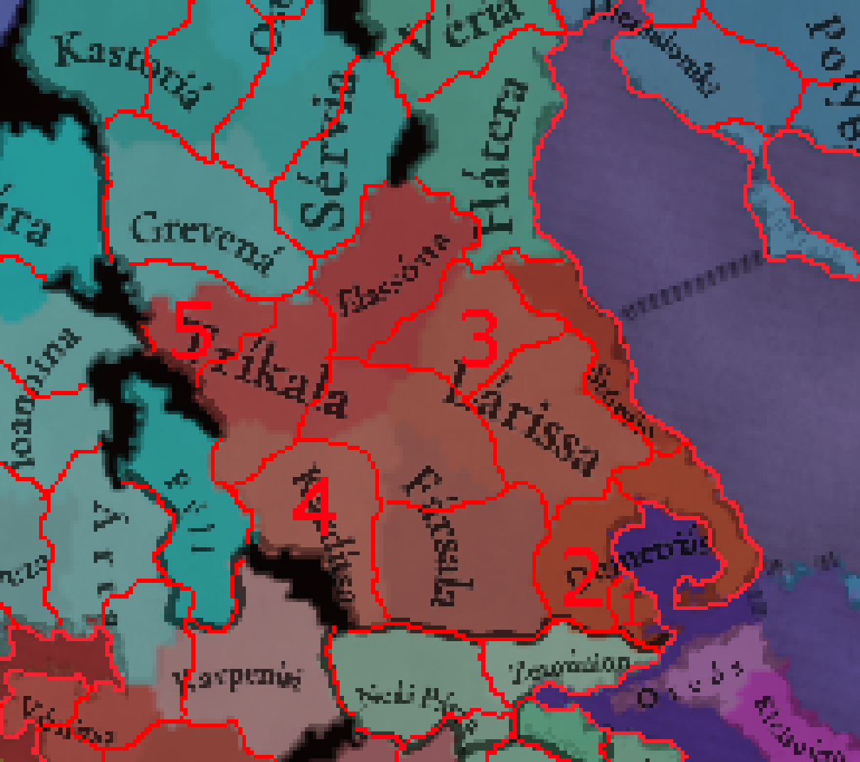
Thessaly
1.
Pteleos
A very small location representing the long time (1322 to 1370, so including the startdate) fortress exclave of Venice, famous for its wines
2.
Almiros / Halmyros
Important Byzantine city during the middle ages, with numerous Italian merchant outposts and a large Jewish community, though it had started to decline with the rise of Volos in the 14th century. Main tradegoods include Fruit, Cotton, Wheat and Salt
The following locations reduce the size of the larger inland Thessaly locations
3.
Tyrnavos
Old Slavic and Aromanian city important during early Ottoman rule
4.
Fanari (Karditsas)
Successor to ancient Ithome, Fanari was an important fortress and bishopric during the 14th century and early Ottoman rule (even becoming an archbishopric)
5.
Stagoi (Kalabaka)
The site of the famous Meteori monasteries built soon after the start date, Kalabaka was the fortress and bishopric of Stagoi in the middle ages, and was one of the capitals of the Serbian pretender emperor Simeon Uroš
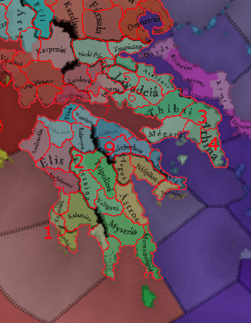
South Greece
1.
Pylos/Navarino
Separate from the "eyes of Venice" in Koroni and Methoni, Pylos was a very important port city (dating back to antiquity, when it was one of the key battlegrounds of the Peloponnesian War) that frequently switched hands between Venice and whomever held the rest of Messenia (with Genoa also having pretensions on it)
2.
Akova/Dimitsana
Fixing some odd shapes in the center of the island, I would add Akova, a Crusader castle and barony, one of the most important baronies of Achea. The most notable town later was Dimitsana, well known for its gunpowder mills which made it very wealthy (perhaps it could have Saltpeter as a tradegood?)
I would love to see the islands of Hydra and Aegina added as locations, but that's unlikely given their size
I wanted to further buff Attica, as one of the most well known areas of Greece and make locations like Athens and Thebes smaller, so I suggest the following locations:
3.
Oropos
Ancient coastal town on the north coast of Attica, a castle and briefly a Venetian exclave in medieval times
4.
Sounio
The cape covering eastern Attica, includes the famous silver mines of Laurion
5.
Gravia
Early Slavic settlement and medieval castle near ancient Pindus
6.
Arachova
Town famous for its cheese that flourished during crusader and early Ottoman rule
7.
Galaxidi
Important port, Byzantine exclave during the 15th century that prospered during the later 18th century as well.
8.
Siderokastron
This would be a very small location, but Siderokastron (near modern Pavliani) was a strategically importantant castle and lordship under the Catalans
An important addition in central Greece would also be Lake Copais, one of the largest lakes in Greece before it was drained in the lake 19th century
9.
Polyphengos (Nemea)
Medieval fortress important in the Middle ages and destroyed by Ottomans during their conquest, near the ancient site of Nemea.
Also seems obvious to me that Kalamata should produce Olives - Kypraissia can be changed from Olives to Wine to compensate
Fish seems like a poor choice of tradegood for Corfu, I would give it Fruit (famous for citrus fruits specifically), Wine or Olives. And while Olives fit Cephalonia, Livestock is probably a better fit given its significant goat herding, while Olives can instead be given to Leukas
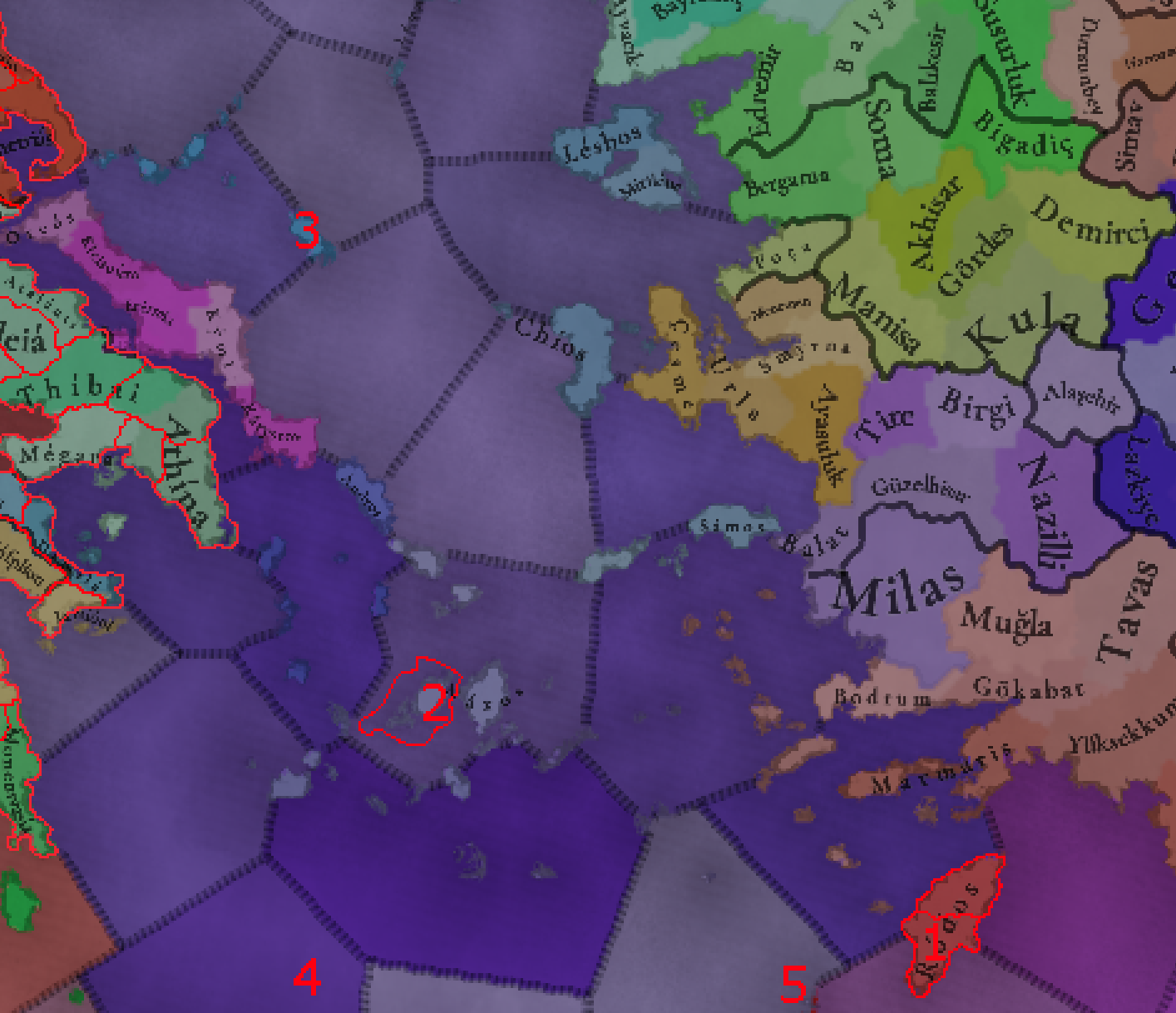
Aegean Islands
1.
Lindos
Rhodes is rather large and very wealthy for an island, as as Lesbos is split, I would also split Rhodes by adding Lindos, an ancient time that had a massive fortress built by the Hospitallers
2.
Paros
Very surprised this one wasn't added yet, as Paros was one of the most important Aegean Islands early in the period, and the most powerful vassal of Naxos under the Sommaripa lords. Paros is very well known for its Marble quarries
Speaking of quarries, Naxos was a prominent quarry of various stones and marbles, but most notably of corundum, so I would change its tradegood to Gems, while Andros was famous for its Silk production, Chios for its mastic (Incense probably?), Samos for Wine, Limnos for its Clay (often eaten due to supposed medicinal properties), Icaria for Livestock, shellfish and charcoal (so Pearls or less likely Coal?), Sporades for its wood (used in shipbuilding, which made Skiathos a major center of it)
Given that Lesbos is the name for the whole island and Mitilini is already separated, I would rename Lesbos location to Kalloni and it's tradegood to Fish, while Mitilini has Olives
3.
Skyros
Skyros certainly seems large enough to separate from the rest of the Sporades, and has slightly different history with longer Venetian rule. Skyros is well known for its ponies, so I would give it the Horses tradegood.
4.
Frangokastello (Sfakia)
Representing the famously wild and independent region of Sfakia, which has a strong regional identity, Frangokastello was an important medieval castle later used by Turks as well. Nearby is the other capital of Sfakia, Hora Sfakion
5.
Ierapetra
Ancient city that was quite wealthy and fortified under Venetian rule. Would probably replace Elounda with it if it isn't added. Well known for Olive Oil
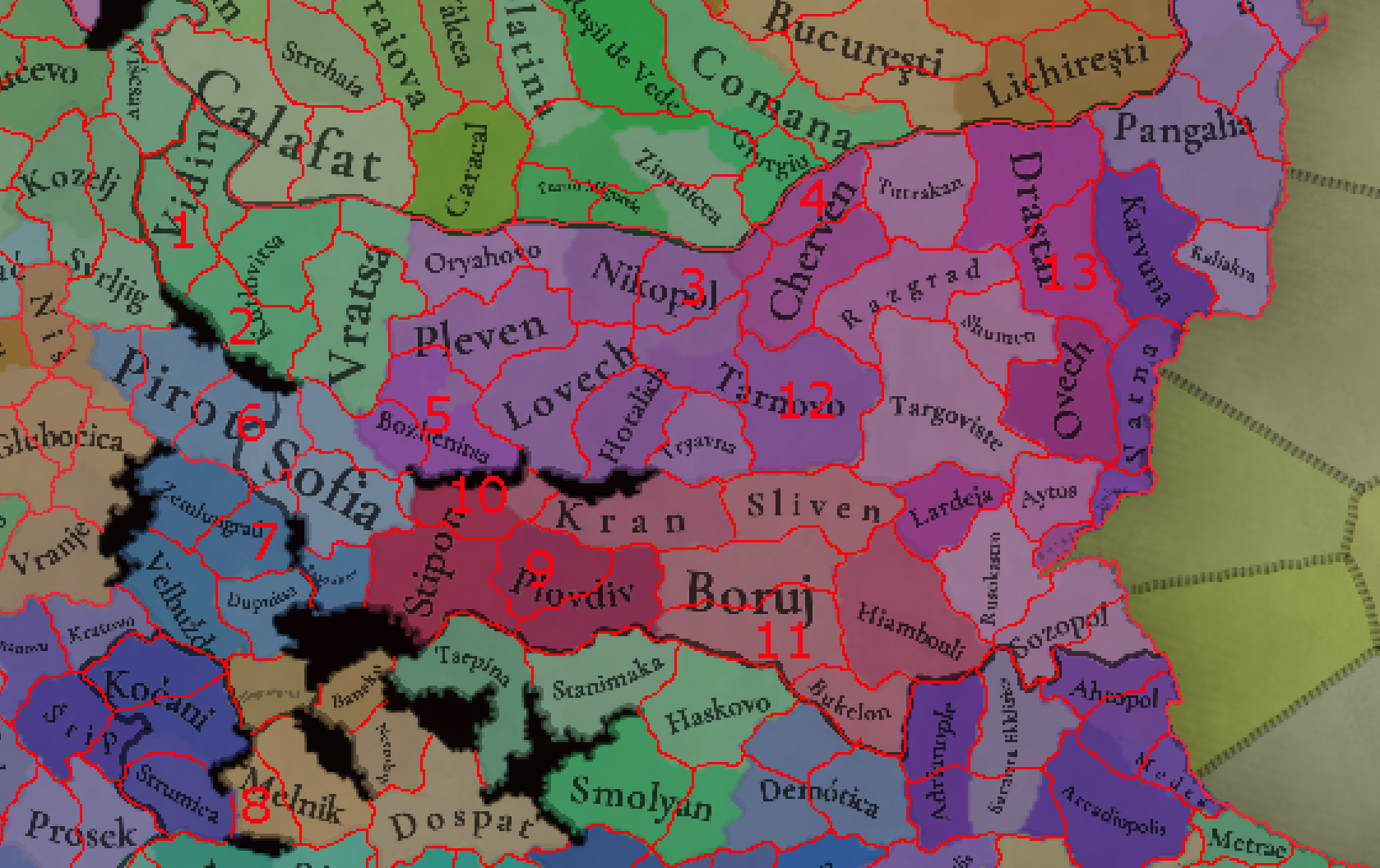
Bulgaria
Bulgaria generally has a pretty good density, but there are certainly locations that can be split, and some important cities and fortresses missing, especially in the northwest of the country
1.
Belogradchik
Massive fortress (and a very unique one, incorporating the local rock formation into its defenses) and the second most importantant one in the Vidin Tsardom. The location would also separate the mountainous part of the current Vidin location from the plains closer to Danube
2.
Chiprovtsi
One of the richest cities in Bulgaria for much of the period (until being destroyed by Ottomans after leading a revolt), Chiprovtsi was a major Gold and Silver mining center (also mining Iron, Lead and Copper, and also being known for its carpet weaving). It's also a major center of Catholicism in Bulgaria, with both German miners and Slavic Catholics. Much like Belogradchik, separates the mountainous from flat parts of the current location
3.
Svishtov
Danube port city that saw the signing of the treaty that ended one of the Austro-Turkish wars
4.
Ruse
While less important than Cherven early in the game's period, Ruse still seems important enough to warrant a location given it grew to become the wealthiest city in Bulgaria by late in the period
5.
Teteven
A very prosperous city under Ottoman rule
6.
Breznik
Representing the border cities between Serbia and Bulgaria (also including Tran and Caribrod), Breznik was an important fortress in medieval times for the defense of Bulgaria and a rich craftsmen town under the Ottomans. It also helps better represent the border between Bulgaria and Serbia, and gets Sofia slightly farther away from the border
7.
Pernik
A key Bulgarian stronghold in the middle ages, and the second most important city in the area in modern and medieval times. A Coal mining region today
8.
Petrich
Strong fortress and one of the most important cities of Pirin Macedonia
Blagoevgrad is a modern name - the location should be called Gorna Dzumaya (Turkish) or Scaptopara (Greek)
9.
Krasen / Pazardzhik
Krasen was a medieval fortress near modern Pazardzhik, the latter of which grew into a major center during Ottoman rule, particularly of Turks and Tatars
10.
Anevo/Kopsis
Large mountain fortress that was briefly the capital of an independent Bulgarian state in the late 13th century
11.
Konstantsiya
Modern Simeonovgrad, Konstantsiya was one of the largest cities in Thrace during the Middle Ages
12.
Rachovets
Modern Gorna Oryahovitsa, suburb of the great Tarnovo with a castle to help in its protection. Helps reduce the size of the Tarnovo and Nikopol/Svishtov locations
13.
Pliska
The first capital of Bulgaria, Pliska has been in ruins since the 10th century, but still feels like the best name for the location added to split the massive Drastar and make the location more centered on Danube
Thrace
1.
Boulgarophygon (Babaeski)
Ancient and Byzantine city. Wheat is the main product of the region
2.
Bizye (Vize)
This is probably the most important addition here - Bizye was an important and large fortified city under the Byzantines and Bulgarians, and later a longtime (from 1470 all the way to 1849!) Sanjak Center under the Ottomans
3.
Cirmen/Ormenio
Another longtime Ottoman sanjak center, site of the battle of Maritsa
4.
Peritheorion
Medieval city and bishopric near ancient Anastasiopolis and modern Amaxades
5.
Zherkovo
Splitting some large inland locations, Zherkovo (modern Kardzali) is a mountain town that was surrounded by strong fortresses of Vishegrad and Monyak. It has a crucial strategic location and was important for both trade and defense of Bulgaria's southern border
6.
Galata
Genovese section of Constantinople, would be cool as a small location but I agree it probably makes more sense as a building.
Carpathia generally has a much lower density than all other regions around it, so here I have quite a few suggestions- I haven't even done the whole region, and others have already made excellent suggestions
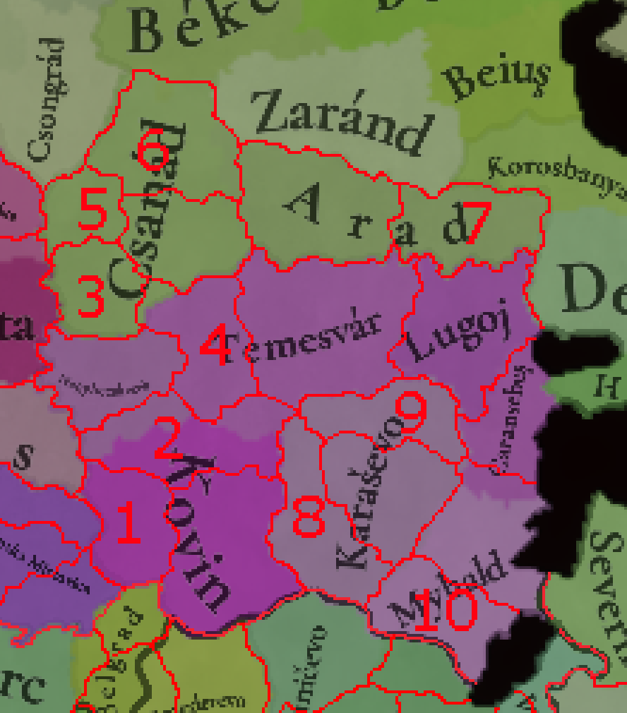
Banat
1.
Pancseva/Pančevo
Important mercantile center and border fortress that is today a large suburb of Belgrade. Would produce Wheat
2.
Nagybecskerek (current Beckerek changed to Torontal)
I would suggest using the borders Torontal county to represent Aracsa (current Novi Bečej), the original capital of Torontal county, while Nagybecskerek (modern Zrenjanin) is added as a larger location to represent the important city. Would also produce Wheat
3.
Kanizsa / Kanjiža
Modern Kanjiža, representing the southern parts of Csanad county, this old town dates back to the early middle ages. Covers an important Wine region
4.
Kokenyd / Kikinda
Representing the western parts of Timis county (in reality it is just slightly outside of it in 15th century, but this really helps represent later county and national borders), Kokenyd (later Nagykikinda, modern Kikinda) was a major military center as a part of the Military Frontier, and in the middle ages there were two nearby settlements of Galad and Hološ
5.
Szeged
One of the most important cities of Hungary, seems obvious
6.
Mako
Later capital of Csanad County, famous for its Legume production (especially onions)
7.
Lipova
Important city, especially in the middle ages and during the Ottoman conquest
8.
Versec/ Vršac
Representing the western part of Krasso country, Vršac is best known for its Wine, but is also more hilly than the rest of the Pannonian plain
9.
Resicabanya
Modern Resita, important town and one of the major industrial centers of Romania today. Would produce Iron to encourage its 18th century Steelworks
10.
Orsova
Most important city in the southeast corner of the Timis county, a major border fort and Danube port in the middle ages. A Clay and Stone mining center
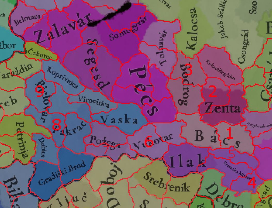
Backa-Slavonia
1.
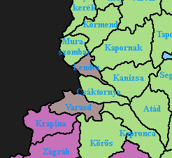
Varad
Modern Novi Sad, the capital of Vojvodina and second most important city of Serbia, Novi Sad is a relatively young city, but it succeeded many older settlements - in the middle ages it was called Varad (not to be mixed with Petervarad (today's Petrovaradin on the other side of the Danube). Would give it Fiber Crops to diversify the Wheat a bit
I would give Bodrogh/Sombor Horses, to represent the Vojvodina tradition of horsebreeding
2.
Szabatka
Modern Subotica, the second most importantant city of Vojvodina today, Subotica was once one of the largest cities of the Habsburg empire, after being favored by Maria Theresia, Szabatka was still a notable town in the middle ages
3.
Baja
The capital of Northern Bacs/Bodrogh, notable town that grew under Ottoman rule of Hungary
Syrmia seems like one of the most underrated regions in Balkans/Carpathia atm, so I tried to buff it by adding two location - there are honestly so many options to add further, such as Ruma or Banoštor, but space is scarce. The following additions also help represent the borders of the Military Frontier
4.
Zemun
Important fortress and trading center now part of Belgrade, Zemun has been a separate city for two thousand years before that. Wheat or Fruit are the best tradegoods
5.
Karom
Modern Sremski Karlovci, this location represents Fruška Gora, the hilly/mountainous northern part of Syrmia that is very rich with Serbian monasteries. Sremski Karlovci were the capital of the Serbian culture and church for centuries despite their small sizes, and in the middle ages Karom was a notable fortress (built atop a Roman one). Also includes Slankamen, major fortified city that served as the capital of the short lived independent Duchy of Syrmia under Radoslav Čelnik
6.
Ðakovo
The seat of the catholic Bishops of Bosnia (banished from Bosnia itself due to the Bosnian Church). We'll known for its horsebreeding
7.
Brod
Now Slavonski Brod, major city along the Sava with the large Vukovac fortress defending it
8.
Kutina
A county center under Hungary
9.
Čazma
One of the oldest towns in Croatia, owned by the Bishops of Zagreb. Later a Sanjak capital under the Ottomans. Clay, Sand and Stone are all mined here
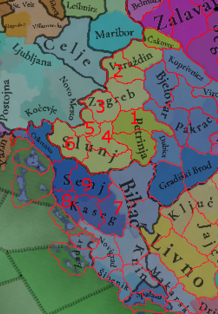
Croatia
1.
Sisak
An extremely obvious inclusion, one of the most important cities in Croatia
2.
Krapina
Important possesion of the Counts of Celje, represents the more mountainous parts of northern Zagorje
3.
Samobor
Free royal city and fortress representing the Žumberak region, later an exclave of the Military Frontier. Well known for its crystal cutting, so Gems seems like an appropriate tradegood
4.
Stenicnjak
Important castle owned by the Counts of Celje
5.
Ozalj
Free royal town owned by the powerful Frankopan and Zrinjski families. Later replaced by Karlovac, the most important city of this part of Croatia and a massive military fortress
6.
Ogulin
Fortified medieval town, later an administrative center of the military frontier
7.
Lapac
Medieval county and fortified city, covering the most mountainous inland parts of Lika. Modern towns include Donji Lapac and Udbina
8.
Bag
Known as Karlobag since 1387, it already had city rights in the 14th century and was one of the main ports of Lika (alongside Senj) through the period
9.
Drežnik / Otocac
Covering the inland parts of Senj, Drežnik was an important fortress protecting Croatia. The location also inclides Otočac, a bishopric center owned by the Frankopan
Dobruja
1.
Constanta
Seems like a very obvious addition, Constanta is the main port and city of Dobruja and has been for centuries. I would add it as a small coastal location, to allow it to serve as an exclave of maritime powers, such as Genoa, which owned it historically
2.
Enisala
Enisala was a powerful medieval fortress of Byzantium, Bulgaria and Genoa. After its decline, the most notable fortress and town in the region was Baba Saltak/Babadag. Early area of Turkish settlement in the Balkans
3.
Isaccea
One of the oldest cities in Dobruja and one of Danube's best crossing points in its lower flow. Another place of Turkish and Tatar settlement (the Tatars also had a mint here). The location also likely includes the mysterious Genovese river port of Vicina
4.
Sulina
Representing the Danube delta, a Byzantine and Genovese port used by pirates. A Greek town
Wallachia
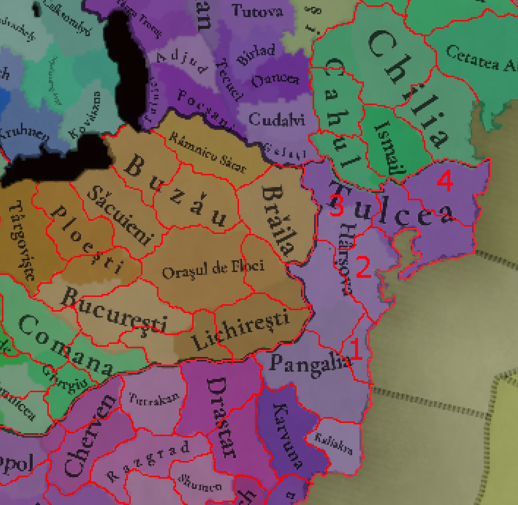
1.
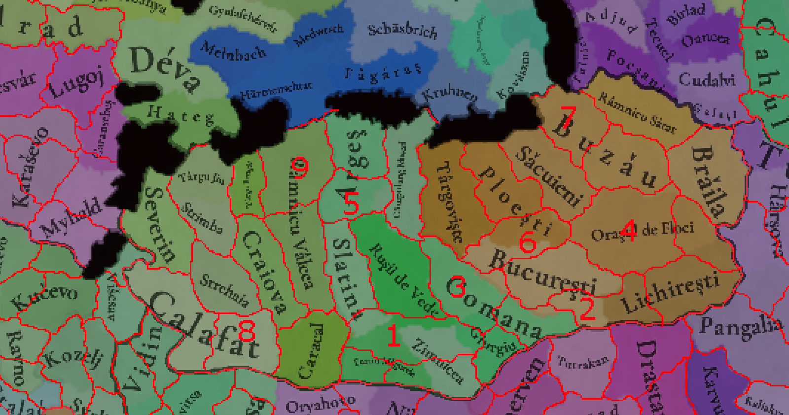
Mavrodin/Buzescu (Alexandria)
This location is kinda necessary to represent the historical borders of Turnu Magurele and Giurgiu, but the most prominent city here (Alexandria) was only founded in the 19th century. The two settlements here I can confirm date to early in the game's timeline are Mavrodin and Buzescu,
2.
Oltenita
Danube river port added to separate Bucharest from Danube and reduce the size of it and Lichiresti
3.
Calugareni
Splitting the large and oddly shaped Comana, known for a major 16th century battle
4.
Cosereni
Added to make Orasul de Floci a smaller location that hugs the Danube more,
5.
Pitesti
One of the most important cities in Romania already in the 14th century, a trade center with large German and Armenian populations and that served as one of the Wallachian capitals
6.
Snagov
Snagov was one of the most important monasteries in Romania, built atop an ancient thracian settlement. It's best known for being the resting place of Vlad Dracula, but it had significant strategic importance to Wallachia
7.
Parscov
Just added to split the very large Buzau, medieval fortification with nearby monasteries. Livestock producing region
8.
Brancoveni/Bals
Added to split the very large Calafat location, Brancoveni was a feud od the powerful Brancoveanu boyars, while Bals is an old town dating back to the 15th century
9.
Cozia
Splitting the huge Ramnicu Valcea, Cozia is one of the most important monasteries of medieval Romania
Moldavia
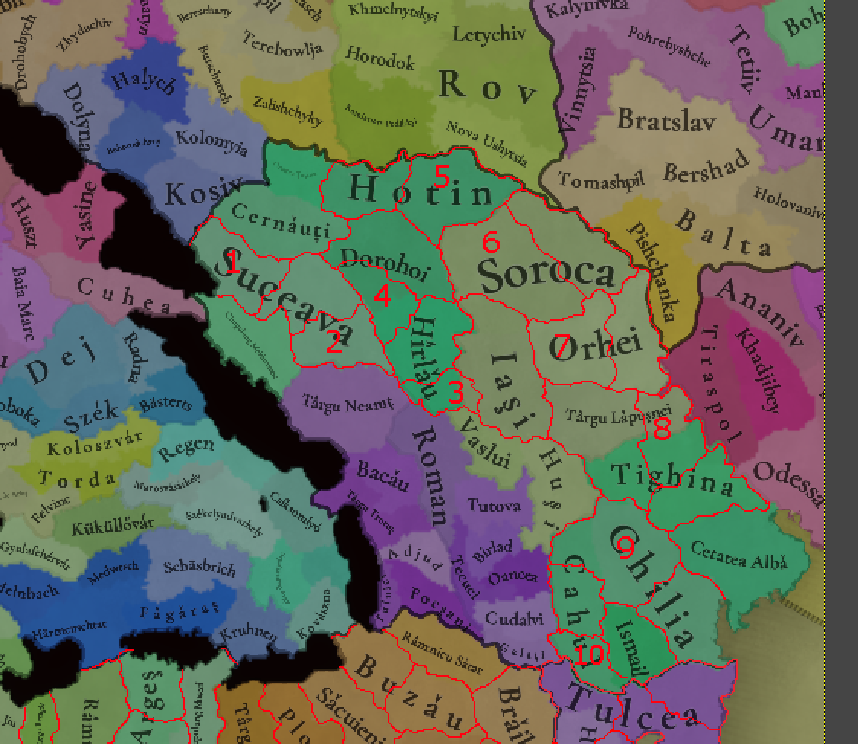
1.
Siret
Extremely obvious addition, one of the oldest towns in Romania and an early capital of Moldavia
2.
Baia
Another old town and early capital, as well as a county center later. A German town
3.
Targu Frumos
Capital of the small Carligatura county, later had a large Jewish community
4.
Botosani
Helps draw the correct border for the Harlau County, a medieval hill fort and market town that grew into one of the largest cities in Moldavia today. German and Hungarian colony which also had a large medieval Armenian and later Jewish population
5.
Lipcani
A Lipka Tatar town, splitting the large Hotin location
6.
Balti
Splitting the large Soroca, a medieval market and craftsmen town that is now the second most important city of Moldova today. Known for its Horses
7.
Ungheni
A split for Orhei. Includes the Jewish town of Calarasi (not to be mixed up with the Calarasi in Wallachia)
8.
Chisnau
Obvious addition, modern capital of Moldova. Also helps give Tighina more accurate borders
9.
Tigheci
Splits the huge Chilia and makes it a more clearly coastal location,
10.
Reni
Old Danube port, helps split the large and long Cahul and better approximate modern borders
West Hungary
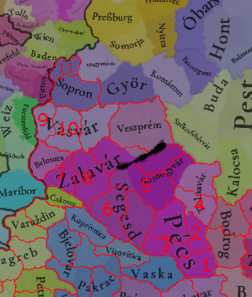
1.
Darda
Ancient castle and town (dating back to roman times), representing the southern parts of Baranya now a part of Hungary. The modern capital is Pelmonostor/Beli Manastir
2.
Mohacs
Famous for its battle that saw the fall of Hungary, it was an administrative capital under the Ottomans
3.
Siklos
Fortified town south of Pecs that saw significant fighting in the Ottoman wars in Hungary
4.
Szeksard
A split for the Tolna county, a significant medieval town and later the capital of Tolna. Also includes the castle of Dombovar
5.
Kapos
Modern Kaposvar, one of the largest cities in Hungary and the later capital of Somogy, administrative and military center under the Ottomans that grew rich under the Esterhazy family
6.
Csurgo
Splitting the large Segesd, Csurgo was a market town with a castle held by the Hospitallers. The area around it was given to free royal swineherds. The location also includes Barcs, the most important town in later times
7.
Lendava
Allows for the full representation of Prekmurje, today a region of Slovenia, historically split between Vas and Zala counties
8.
Nagykanisza
Split for the massive Zala, one of the most important strongholds of medieval Hungary and an eyalet capital under the Ottomans, as well as an important trade center
9.
Nemetujvar/Güssing
Representing the middle parts of Burgenland (today in Austria), Güssing was an important fortress of Western Hungary, a prosperous town and a Free Imperial City since the 16th century
10.
Szombathely
Further splitting the huge Vasvar, Szombathely is the oldest city in Hungary (dating back to Roman Savaria), a free royal town and the modern capital of Vas County (since 1578)
11.
Eisenstadt
The capital of Burgenland, along with Güssing it seems like an obvious addition, especially as it was already leased by Austria from 1440 and was a medieval fortress city with market rights
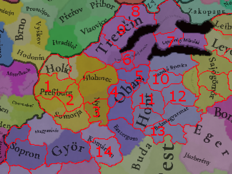
West Slovakia
1.
Nagyszombat/Trnava
Large and important city that adds further depth to the wealthy Poszony County, especially important as a religious center. A German majority town in the 14th century
2.
Szenice/Senica
Another addition to Poszony, received city rights in the 14th century
3.
Ersekujvar/Nove Zamky
One of the most obvious additions (even if it requires shifting the location of Nyitra), a major fortress in defense against the Ottomans and a longtime capital of the Capitancy of Lower Hungary and then an Ottoman Eyalet
Though Obars gave its name to the Bars county, by 1337 the much larger nearby town of
Leva/Levice was already the capital and should be the name of the location. I would further add two locations to the county
4.
Aranyosmarot/ Zlate Moravce
The later capital of Bars, named for its significant production of Gold
5.
Kormocbanya/Kremnica
Another important Gold mining town, with the oldest still working mint in the world, the capital of Slovakia's golden mines and an important German town
6.
Privigye/Prievidza
Representing the odd jutting out part of the borders of Nyitra County, a free royal town
7.
Rozsahagy/Ruzomberok
Splitting up Lipto County, later one of the centers of Slovak national revival
8.
Zsolna/Zilina
A very obvious addition in the north of Trencsen, one of the largest cities in Slovakia since the 17th century
9.
Vagbeszterce/Povazska Bystrica
The other addition to Trencsen, important fortress in the middle ages
10.
Zolyom/Zvolen
The namesake of Zolyom County seems like another obvious addition. Important trading center which received one of the first town privileges in Hungary
11.
Ipolysag/Sahy
Splitting up Hont County, it's later capital. A sanjak centre under the Ottomans
12.
Losonc/Lučenec
Splitting up northern Nograd County, also it's later capital. Also includes Filakovo, a sanjak center under the Ottomans
13.
Vác
In modern Hungary, southern part of Nograd. The bishops of Vac were very influential in medieval Hungary. A German town in the middle ages
14.
Tata
Southern, modern Hungarian half of Komarom county. Important fortress and town, especially under Ottoman rule
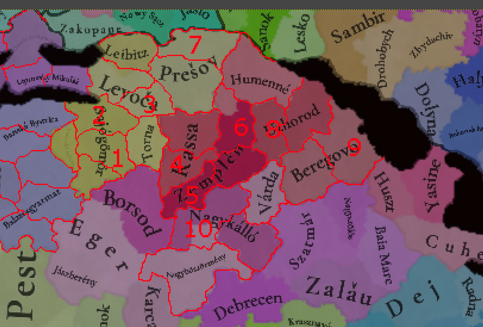
East Slovakia
1
. Rozsnyo/Roznava
Religious and modern center of Gemer, free royal town since 1410 and major mining center (of gold, silver and especially Iron) throughout the period
2.
Murany/Muran
Northernmost part of Gemer, a castle town with major iron mines
3.
Iglo/Spišska Nova Ves
Additional location in Szepes, a mining town that had the largest market in Hungary and grew very wealthy of its mining and crafting
4.
Abaujszanto
The second largest city in Abauj after Kassa through the period, now a small town. Also includes Gonc (capital of Abauj County between 1570 and 1647) and the royal town of Szikso
5.
Tokaj
Famous wine producing town, splitting the large Zemplen
6.
Nagymihaly/Michalovce
Representing the middle parts of Zemplen, a small town earlier through the period that saw significant growth in 18th and 19th centuries
7.
Bartfa/Bardejov
Northern half of Saros, very wealthy town in the middle ages and later a major center of Jews in Hungary and Czechoslovakia
8.
Nagykalpos/Velke Kapusany
Western part of Ung county, currently in Slovakia rather than Ukraine. Nagykalpos was the second largest town of the county since the middle ages
9.
Munkacs/Mukachevo
Northern half of Bereg County, Mukachevo is today the second largest city of Zakarpatya, and has been its religious center for centuries, as well as a major Jewish center (even being majority Jewish)
10.
Nyiregyhaza
Representing the western half of Szabolcs County, one of the largest cities in Hungary since the 18th century
That's it for this time! I will try to also post a map dump of interesting and useful maps sometime later today!


 This week we’re posting the general map of the region, along with some more detailed maps, that can be seen if you click on the spoiler button. A starting comment is that the location density of Hungary is noticeably not very high; the reason is that it was one of the first European maps that we made, and we based it upon the historical counties. Therefore, I’m already saying in advance that this will be an area that we want to give more density when we do the review of the region; any help regarding that is welcome. Apart from that, you may notice on the more detailed maps that Crete appears in one, while not being present in the previous one; because of the zooming, the island will appear next week along with Cyprus, but I wanted to make an early sneak peek of the locations, given that is possible with this closer zoom level. Apart from that, I’m also saying in advance that we will make an important review of the Aegean Islands, so do not take them as a reference for anything, please.


 Country and location population (which I’ve also sub-divided, and is under the Spoiler button).


