• We have updated our Community Code of Conduct. Please read through the new rules for the forum that are an integral part of Paradox Interactive’s User Agreement.

Tinto Maps #9 - 5th of July 2024 - Carpathia and the Balkans

Greetings, and welcome to another Tinto Maps! This week we will be taking a look at Carpathia and the Balkans! It will most likely be an interesting region to take a look at, with a lot of passion involved… So I’ll just make an initial friendly reminder to keep a civil discussion, as in the latest Tinto Maps, as that’s the easiest way for us to read and gather your feedback, and improve the region in a future iteration. And now, let’s start with the maps!

Countries:
Countries.png

Carpathia and the Balkans start in a very interesting situation. The Kingdom of Hungary probably stands as the most powerful country in 1337, but that only happened after the recovery of the royal power enforced by Charles I Robert of the House of Anjou, who reined in the powerful Hungarian nobility. To the south, the power that is on the rise is the Kingdom of Serbia, ruled by Stefan Uroš IV Dušan, who has set his eyes on his neighbors to expand his power. The Byzantine Empire, meanwhile, is in a difficult position, as internal struggles ended in Andronikos III being crowned sole emperor, at the cost of dividing the realm; both Serbia and Bulgaria have in the past pressed over the bordering lands, while the Ottomans have very recently conquered Nicomedia. The control over the Southern Balkans is also very fractioned, with a branch of the Anjou ruling over Albania, the Despotate of Epirus under the nominal rule of Byzantium as a vassal, Athens, Neopatria and Salona as vassals of the Aragonese Kings of Sicily, Anjou protectorates over Achaia and Naxos, and only nominal Byzantine control over Southern Morea. It’s also noticeable the presence of the Republics of Venice and Genoa, which control several outposts over the Adriatic and Aegean Seas. A final note: in previous maps, Moldavia was shown in the map, but we’ve removed it from it, and it will most likely spawn through a chain of events in the 1340s.

Dynasties:
Dynasties.png

The House of Anjou rules over Naples, Hungary, Albania, Achaia, and Cephalonia; they’re truly invested in their push for supremacy over the region. Apart from that, each country is ruled by different dynasties, except for Athens and Neopatria, ruled by the House of Aragón-Barcelona.

Locations:
Locations 1.png

Locations 2.png

Locations 3.png

Locations 4.png
This week we’re posting the general map of the region, along with some more detailed maps, that can be seen if you click on the spoiler button. A starting comment is that the location density of Hungary is noticeably not very high; the reason is that it was one of the first European maps that we made, and we based it upon the historical counties. Therefore, I’m already saying in advance that this will be an area that we want to give more density when we do the review of the region; any help regarding that is welcome. Apart from that, you may notice on the more detailed maps that Crete appears in one, while not being present in the previous one; because of the zooming, the island will appear next week along with Cyprus, but I wanted to make an early sneak peek of the locations, given that is possible with this closer zoom level. Apart from that, I’m also saying in advance that we will make an important review of the Aegean Islands, so do not take them as a reference for anything, please.

Provinces:
Provinces.png

Provinces! Nothing outstanding to be commented on here; as usual, we’re open to any feedback regarding them.

Terrain:
Climate.png

Topography.png

Vegetation.png

Terrain! The climate of the region is mostly divided between Continental and Mediterranean, with some warmer and some colder regions. Regarding the topography, the Carpathian mountains are famously important and strategic, while the Balkans are a quite hilly and mountainous region, which is also greatly covered by woods and forests.

Cultures:
Cultures.png

Here comes the fun part of the DD: The cultural division of the Balkans! A few comments:
  1. Hungary is full of different minorities. Transylvania, especially, is an interesting place: there we have a mix of ‘Hungarians’, ‘Transylvanians’ (which are the Romanian-speaking inhabitants of the region), ‘Transylvanian Germans’, and ‘Szekely’ people.
  2. We have divided the Southern Slavic-speaking region into their dialectal families of Slovene, Croatian, Bosnian, and Serbian.
  3. The Southern Balkans are mostly divided among Bulgarian, Albanian, and Greek cultures.
  4. We’re also portraying plenty of other cultures, such as Dalmatians, Aromanians, Sclavenes, Arvanites, Cumans, Jasz, or Ashkenazi and Romanyoti Jews.

Religions:
Religion.png

This one is also interesting. Apart from the divide between Western Catholicism and Eastern Orthodoxy, we have the Krstjani in Bosnia, Bogomils (the pink stripes both in Bosnia and Macedonia), and Paulicians in Thrace. The Jewish populations do not pass the threshold percentage to appear on the map, but there are plenty of communities across the region.

Raw Materials:
Raw Materials.png

The materials of the region. Something very noticeable is the richness of minerals, with plenty of Iron, Copper, Tin, Lead, Gold, and Silver. Specifically, Slovakia is very rich, and you definitely want more settlers to migrate to the region, and exploit its resources. The region is also very rich in agricultural resources, as you can see.

Markets:
Markets.png

The region is mostly divided among four markets: Venice, Pest, Ragusa and Constantinople.

Country and Location population:
Population 1.png

Population 2.png

Population 3.png

Population 4.png
Country and location population (which I’ve also sub-divided, and is under the Spoiler button).

And that’s all of today! I hope that you find the region interesting; we certainly think that it is. Next week we will go further south, and we will take a look at the Syrian Levant and Egypt. Cheers!
 
  • 193Like
  • 69Love
  • 7
  • 4
  • 3
  • 1Haha
Reactions:
Apologies for the long post, I have tried to structure it in a readable manner. Here are my suggestions regarding Bulgaria and the surrounding territories:


Suggestions for spelling changes (generally all of the cases of “j” should be replaced with “y” as per the rules of transcribing Bulgarian:

Boruj->Boruy

Lardeja->Lardeya


Suggestions for naming changes:

Tarnovo->Tarnovgrad

Vidin (the name is a corruption of the original under Turkish influence)->Bdin

Blagoevgrad (named after the founder of the communist party and also the city didn’t really exist in the middle ages->Stob (a nearby location which used to be a city with significance)

Smolyan (named in the 20th century and was formed as an amalgamation of several villages)->Dyovlen (different city nearby with significance for the age)

Haskovo (name is most likely in some way formed from Turkish and its name in the middle ages in unknown)->Mezek (a big fortress nearby)

Sofia-Sredets

Vratsa->Vratitsa

Razgrad->Hrazgrad

Targoviste->Kosovo or Misionis

Tulcea->Tulitsa

Pangalia->Konstantsa (different city, but way more important)

Hârşova->Harsovo

Dobruja province->Dobrudzha or Karvuna

Tarnovo province->Tarnovgrad

Rhodopes province->Rodopi

Vidin province->Bdin

Shopluk province (the -luk ending is Turkish in origin)->Shopsko

Silistra province (an anachronism at that time)->Drastar


Suggestions for Bulgarian names for some of the locations outside Bulgaria:

Kilkis->Kukush

Serres->Syar

Xanthia->Ksanti

Edessa->Voden

Florina->Lerin

Komotini->Kumutsina

Adrianople->Odrin

Saranta Ekklistes->Lozengrad

Veria->Ber

Kastoria->Kostur

Thessaloniki->Solun

Constantinople->Tsarigrad (don’t forget the “i”, it’s not Tsargrad, that would be Russian)

Kočani->Kochani

Strumica->Strumitsa

Štip->Shtip

Skopje->Skopie

Bitola->Bitolya

Kitsabis->Kichevo

Tetovo->Htetovo

Dupnitsa -> Dubnitsa

Zemlungrad->Zemlangrad or Zemlengrad

Prokuplje->Prokuple

Vranje->Vranya

Svrljg->Svarlig

Kozelj->Kozel

Višesav->Vishesav

Niš->Nish

(and so on, all names with “š” should have “sh”, if owned by Bulgaria, “č” and “ć” should be “ch” and “j” should be “y”. “C” in other south Slavic languages should be transcribed as “ts” if owned by Bulgaria)

Giurgiu->Yorgovo

Zimnicea->Zimnitsa

Turnu Magurele->Malak Nikopol or Holavnik

Braila->Braila (without the a with dash)

(I hope other forumites can help here with the Slavic and Bulgarian names for the locations in Wallachia since it was ruled for a few hundred years by Bulgaria, but the exact forms of the toponomy that was used at the time is hard to find)


Suggestions for new locations:

Nesebar should be added, taking the northern part of Anhialo and the southern part of Varna and it should produce wine.

Preslav should be added between Targoviste and Shumen.

Perperek/Perperak east of Smolyan west of Haskovo.

Pernik west of Sofia and east of Zemlungrad.


1720215980514.png


Suggestions for border changes:

Višesav, Kozelj and Svrljg and the whole Vidin province should belong to Bulgaria or to a despotate of Vidin (if it is decided to place it on the map on the starting date) that would establish the historical border between Bulgaria and Hungary from which Hungary invaded Bulgaria more than once.


EDIT: Suggestions for impassable terrain:

Generally, there should be a lot more impassable locations between the Danube plain in Northern Bulgaria and the southern land due to the Balkan mountains. More like the map of Imperator: Rome, although the mountain passess were even less than the map suggested there. These mountain passess were crucial even up to the Russo-Turkish war of 1877-1878, so they should not be underestimated. Ideally there should be no more than 4 or 5 to simulate the reality of the terrain. As other people mentioned the "Hills" of central Bulgaria should be mountains.
I understand however that the addition of more impassable terrain can be unwanted from a gameplay perspective. If @Pavía @Johan of anyone else could share their view on the topic it would be helpful.

EDIT EDIT: Posting my impassable terrain suggestions from my other post:

Following up on my suggestions, the impassable terrain map should look something like this:

1720260183912.png


The possible crossings to the east of Bulgaria should be limited to two: one between Sliven and the current location of Targovishte and between Varna and what I have proposed to be Nesebar.


Suggestions for the Bulgarian dynasty:

It should not be Sratsimir but rather Shishmanovtsi or Shishman.


Suggestions for culture:

The locations in the provinces of Niš, Braničevo, Vidin and Shopluk (and possibly Toplica and Kosovo) should realistically have Bulgarian culture instead of Serbian as those locations formed part of the first and second Bulgarian tsardoms from the 800s up until the 1250s. These lands only came under Serbian influence since the 1250s (given the genesis of the Serbian state more to the west in Raska) and only gradually from west to east. Thus the whole of in the whole of Vidin, Shopluk and Niš there should be little Serbian culture present. Braničevo, Toplica and Kosovo should have some Bulgarian minorities.

Just to clarify and ward off any potential backlash against this, I should mention that the languages back then were very close and show only initial signs of differing evolution. On top of that both cultures are majority Orthodox and the local Slavs would easily assimilate and identify with the state that rules them. As such (and with the caveat of not knowing how culture works in Project Ceasar) I propose that these Bulgarian pops in these provinces should be able to assimilate to Serbian should Serbia be able to hold these lands longer than it did historically and vice-versa, should Serbian pops fall under Bulgaria they should be able to be assimilated in a century and half to two centuries. This should be able to simulate how cities such as Belgrade became Serbian in culture despite being ruled for centuries by Bulgaria.
 
Last edited:
  • 6
  • 5Like
  • 2
Reactions:
I can see the performance concern, but Krstjani is still fairly large on these maps compared to Bogomilist and Paulician (only the stripes in Thrace), plus they have Krstjani in CK3 anyway. Given their stated focus is on being as historically accurate as possible, I think it is up to the community to present the best case for each religion, and then let them decide what is possible to include given performance limitations.
What I was arguing is that Krstjani could have been incorporated into Bogomils for the sake of performance, while vice-versa cannot be done. But if even Paulicians are present and separate from Bogumils, then Krstjani and Bogumils should definitely be separate.
 
Also ethnic Bosniak here.
I think if you take the cumulative effect of the Bosnian Church, Bosancica script, and other developments by the time of 1337, it is enough for the culture to be more like in its 'adolescence'. After all, we are only a few decades away from the peak of the Bosnian kingdom in importance and influence. I would agree on making Hum majority Serb, due to the presence of early Orthodox monasteries in the area, but for Usora and Soli I disagree, could be perhaps a Serbian minority since these areas were still quite close to the hinterlands of Bosnia with strong Bosnian Church influence. There is the limitation of province sizes to consider, but given that most of the kingdom's most important towns and settlements were in/near the center of the country, I would say the population there (more likely to be distinctly Bosnian than Serbian) should dictate the culture stripes.
I honestly don't know, but my opinion is that the population in Usora and Soli is mostly krstjan but not mostly Bosnian in that area, I belive in a game sense the area is ripe to sway ether Serbian or Bosnian majority, and I'm basing this on next to nothing historicaly... Tho I disagree that we should call the Bosnian culture at that stage as being in its "adolescence", it would be hard to argue that considering it so easily converted to Islam when the Ottomans arrived, one would expect more resistance.
 
I agree about most of the things. My notes:
- The castle at Targoviste is Kosovo (Misionis). It's not Targoviste Targoviste was a trade station initially during Ottoman rule. Then a settlement was created.
- Preslav was alive and well in the 14th century, ruined by the Ottomans.
I read that Preslav was destroyed by Tatar raids at the end of the 13th century, and was pretty much abandoned. I get your point about Misionis/Kosovo, though. Even though I still wouldn't mind Targoviste (which indeed developed during early Ottoman times, but I think it's important enough and an acceptable anachronism).
 
Last edited:
Well my friend, I called this out 1 month ago.


And I began with:

Unfortunately, Paradox has a history of inaccuracy when it comes to the Carpathian region and Romanians specifically. We understand that Romania is not the most popular subject in western history, to put it mildly. Most westerners are interested in England, France, Spain, Portugal, Italy, Germany, Russia, Ottomans and maybe Hungary and Poland at best. But we would like to play as historically accurate Romanians:
- In CK2 Wallachia and Moldavia's rivers and regions were completely wrong to the point where it looked like a parody of a map.
- The Vlachs (Wallachians and Moldavians) were listed as slavic despite not being so.
- Moldavia didn't even exist as a formable kingdom despite other 100% made up formable kingdoms existing in CK2.
- Only the geographic regions being wrong were updated in one of the last patches.
- It took CK3 to add Moldavia, but the Vlachs were still south slavic.
- Only after a few updates they finally changed the Vlachs from South Slavic to their own cultural group.
- EU4 for example doesn't have Pokuttia as part of Moldavia despite Moldavia owning Pokuttia in 1444.
- If you look at EU4's map, Suceava is much lower than where it should be. It's basically in Neamt and where Suceava should be is Halicz. This is not even history just geography.

Looks like the trend continues.

Because f**k Romania, they are too eastern to care about them.
If they werent interested we wouldnt be here discussing this - with basically a promised massive rework. While im also very unhappy with the current set up of the map (so much so that I spent 2 hours drawing out my suggested changes), I absolutely love and appreciate Paradox's uniqly constructive stance on this. Lets focus on working with them and trying to be constructive.
 
  • 8Like
  • 4
Reactions:
Apologies for the long post, I have tried to structure it in a readable manner. Here are my suggestions regarding Bulgaria and the surrounding territories:


Suggestions for spelling changes (generally all of the cases of “j” should be replaced with “y” as per the rules of transcribing Bulgarian:

Boruj->Boruy

Lardeja->Lardeya


Suggestions for naming changes:

Tarnovo->Tarnovgrad

Vidin (the name is a corruption of the original under Turkish influence)->Bdin

Blagoevgrad (named after the founder of the communist party and also the city didn’t really exist in the middle ages->Stob (a nearby location which used to be a city with significance)

Smolyan (named in the 20th century and was formed as an amalgamation of several villages)->Dyovlen (different city nearby with significance for the age)

Haskovo (name is most likely in some way formed from Turkish and its name in the middle ages in unknown)->Mezek (a big fortress nearby)

Sofia-Sredets

Vratsa->Vratitsa

Razgrad->Hrazgrad

Targoviste->Kosovo or Misionis

Tulcea->Tulitsa

Pangalia->Konstantsa (different city, but way more important)

Hârşova->Harsovo

Dobruja province->Dobrudzha or Karvuna

Tarnovo province->Tarnovgrad

Rhodopes province->Rodopi

Vidin province->Bdin

Shopluk province (the -luk ending is Turkish in origin)->Shopsko

Silistra province (an anachronism at that time)->Drastar


Suggestions for Bulgarian names for some of the locations outside Bulgaria:

Kilkis->Kukush

Serres->Syar

Xanthia->Ksanti

Edessa->Voden

Florina->Lerin

Komotini->Kumutsina

Adrianople->Odrin

Saranta Ekklistes->Lozengrad

Veria->Ber

Kastoria->Kostur

Thessaloniki->Solun

Constantinople->Tsarigrad (don’t forget the “i”, it’s not Tsargrad, that would be Russian)

Kočani->Kochani

Strumica->Strumitsa

Štip->Shtip

Skopje->Skopie

Bitola->Bitolya

Kitsabis->Kichevo

Tetovo->Htetovo

Dupnitsa -> Dubnitsa

Zemlungrad->Zemlangrad or Zemlengrad

Prokuplje->Prokuple

Vranje->Vranya

Svrljg->Svarlig

Kozelj->Kozel

Višesav->Vishesav

Niš->Nish

(and so on, all names with “š” should have “sh”, if owned by Bulgaria, “č” and “ć” should be “ch” and “j” should be “y”. “C” in other south Slavic languages should be transcribed as “ts” if owned by Bulgaria)

Giurgiu->Yorgovo

Zimnicea->Zimnitsa

Turnu Magurele->Malak Nikopol or Holavnik

Braila->Braila (without the a with dash)

(I hope other forumites can help here with the Slavic and Bulgarian names for the locations in Wallachia since it was ruled for a few hundred years by Bulgaria, but the exact forms of the toponomy that was used at the time is hard to find)


Suggestions for new locations:

Nesebar should be added, taking the northern part of Anhialo and the southern part of Varna and it should produce wine.

Preslav should be added between Targoviste and Shumen.

Perperek/Perperak east of Smolyan west of Haskovo.

Pernik west of Sofia and east of Zemlungrad.


View attachment 1159058

Suggestions for border changes:

Višesav, Kozelj and Svrljg and the whole Vidin province should belong to Bulgaria or to a despotate of Vidin (if it is decided to place it on the map on the starting date) that would establish the historical border between Bulgaria and Hungary from which Hungary invaded Bulgaria more than once.


Suggestions for the Bulgarian dynasty:

It should not be Sratsimir but rather Shishmanovtsi or Shishman.


Suggestions for culture:

The locations in the provinces of Niš, Braničevo, Vidin and Shopluk (and possibly Toplica and Kosovo) should realistically have Bulgarian culture instead of Serbian as those locations formed part of the first and second Bulgarian tsardoms from the 800s up until the 1250s. These lands only came under Serbian influence since the 1250s (given the genesis of the Serbian state more to the west in Raska) and only gradually from west to east. Thus the whole of in the whole of Vidin, Shopluk and Niš there should be little Serbian culture present. Braničevo, Toplica and Kosovo should have some Bulgarian minorities.

Just to clarify and ward off any potential backlash against this, I should mention that the languages back then were very close and show only initial signs of differing evolution. On top of that both cultures are majority Orthodox and the local Slavs would easily assimilate and identify with the state that rules them. As such (and with the caveat of not knowing how culture works in Project Ceasar) I propose that these Bulgarian pops in these provinces should be able to assimilate to Serbian should Serbia be able to hold these lands longer than it did historically and vice-versa, should Serbian pops fall under Bulgaria they should be able to be assimilated in a century and half to two centuries. This should be able to simulate how cities such as Belgrade became Serbian in culture despite being ruled for centuries by Bulgaria.
Mostly agree. Vidin province should be entirely inside Bulgaria. The vassal rebellion there was crashed by 1337.

I would like to add the following (already wrote it in a separate Thread):
Big Province structure and names:

1.Silistra in Bulgarian was never called that way in the middle ages (before Ottomans). The province name was Drastar (like the location).

2.Zagore was used to describe a lot of things (incuding the whole of Bulgaria) in the sources, however in provincial point of view - it was not used in the lands west of Boruj. The lands west of Boruj should be named Plovdiv (Philipoppolis) (the same name as the location). There used to be a duchy of Philipoppolis as a crusader state, before being reintegrated in Bulgaria. Also Zagore should probably include Haskovo, since Haskovo is not in the Rhodopes (even if in an other country).

3. Shopluk is a folklore/ethnographic term, not a geographic or administrative one. The Province was never named that way. My suggestion is to either named it after the biggest city Sredets or to split the province to Sredets and Velbajd.

Trade goods:

1. Having the farmlands of Plovdiv on the Matitsa Valley as Timber makes little sense. The province is today important in Fruit and vegetable production. In the middle ages it was important for Horses. The Byzantines recruited Kathafracts there. So I think Horses or Fruit make the most sense.

2. At least one, if not all the Rhodope locations in Byzantium should produce wool.

3. At least one of Dobrudja Provinces should produce Horses. Dobrudja (little Scitia) was a source for Horses since Antiquity.

4. Sofia (more specifically Samokov) was important in Metalworks in the 13 hundreds. I think it should produce Iron.
 
  • 3
  • 2
Reactions:
If they werent interested we wouldnt be here discussing this - with basically a promised massive rework. While im also very unhappy with the current set up of the map (so much so that I spent 2 hours drawing out my suggested changes), I absolutely love and appreciate Paradox's uniqly constructive stance on this. Lets focus on working with them and trying to be constructive.
I mean, I wish I would believe you. I wish I would believe Paradox was a team that takes every civilization seriously. This is what I would like to believe.

But when the issue for Romania are from CK2 (as far as I can tell) and keep going, what would you believe in my place?

Even Hoi4 had issues with Romania. Hoi4, where there are tons of documents for everything.

I mean they made King Michael's Coup against his father, Carol II, despite that never being the case. King Michael I made the coup against Ion Antonescu.

Today, things are better but not historically accurate. If you pick Octavian Goga as the leader, you will still play as Legionary Romania. It's only a google search away from the fact that Octavian Goga was not a Legionary. He was more like Hitler where as legionaries were their own thing. This is not a "finer detail" it's literally a one google away.

What am I to say of the fact that Ion Antonescu was never in the Legionary Movement himself and even opposed Horia Sima, which once again, you can check on Wikipedia, it's that simple. It's not even a big debate. They had conflict since they came to power together and Germany expected both of them to behave even though they both hated each other.

This is no esoteric knowledge, but very simple to access. And they still messed it up somehow.

And again, I'm giving Hoi4 as an example where there is a lot of documentation. And you don't need to read books to know what I told you, just even the most basic stuff such as looking on Wikipedia.

Heck, they even started with the wrong prime minister and ideology in 1936 before I told them about it. How little do you have to care to get the prime minister and ideology wrong?

So how can I justify the fact that they got even that one wrong? Other than because f**k Romania, they are too eastern to care about them.

It's like "too eastern for us, here it will do whatever".
 
  • 6
  • 1Like
Reactions:
Please double-check dynamic names I will suggest for cultures other than Romanian in this post, I could get the spelling wrong in some cases.

MOLDAVIA:

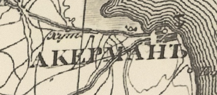
Cetatea Albǎ
- Cetatea Albă (A-breve instead of A-caron); dynamic names: Asprokastron (Ἀσπρόκαστρον; Byzantine); Moncastro (Genoese and Golden Horde); Akkerman (Ottoman); Aqkermen (Crimean Tatar); Weißenburg (German); romanisation of the name in the spoilered pic below (Akerman?) (Russian)
1720197527325.png

(screenshot taken from a Russian map from the year 1832, when it was already part of the empire)
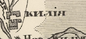
Chilia - all good in Romanian; dynamic names: Kili (Ottoman), Lykostomo (Λυκόστομο) (Byzantine), Licostomo (Genoese and Golden Horde) (warning: whether Chilia and Licostomo are one and the same is highly debated; recent research strongly suggests that Licostomo was located lower on the Danube, where the present-day Vylkove is; however, from a gameplay perspective, this shouldn't matter as they are very close to each other and are part of the same location), Kiliya (Russian)
1720199200951.png
Ismail - Smil (Romanian); İzmail (Ottoman); Izmail (Russian)
Cahul - rename to Șcheia (it was later renamed to Frumoasa, and it was only in 1835 that it was renamed to Cahul)
Tighina - all good in Romanian; Bender (Ottoman); Bendery (Russian)
Galați - all good
Cudalvi - I assume it's a typo of Cudalbi; that being said, I'm surprised this is a location at all, I'd like to hear more about this choice and why it's not simply a part of Galați
Tulnici - all good
Focşani - another complicated one; it's true that the town of Focșeani (with s-comma) ends up being a very important customs point between Wallachia and Moldavia), but it only gets mentioned in documents for the first time in 1546; prior to that we have a different settlement named Putna; I'll leave the choice to the devs
Tecuci - rename to Tecuciu
Oancea
- all good
Bîrlad - rename to Bârladu (I have seen the alternate form Bărladu, but as far as I can tell it may have been a 19th century thing)
Adjud - rename to Agiud (Аџюд)
Târgu Trotuş - rename to Trotuș (it was called Totruș before, but it already became Trotuș by 1408)
Tutova - this actually gives me some difficulty because it's the name of a district, not of a settlement, and there's no major settlement there; the spelling is correct, but I'd rather have this location disappear and have Fălciiu appear nearby; but more on that, when I start talking about border adjustments
Huşi - rename to Huși (s-comma)
Vaslui - rename to Vasluiu
Bacǎu
- rename to Bacău (A-breve)
Roman - rename to Romanu
Târgu Lǎpuşnei
- rename to Lăpușna
Orhei
- rename to Orheiu; in Golden Horde hands, it should be called Shehr al-Jedid (maybe Shehr al-Jadid?) or Yangi-Shehr; they both mean New Town, and according to this page, "Yangi-Shehr, where yangi means new and shehr means town, is the name of the place written in a Turkic language, probably Chagatai (debatably the ancestor of Uzbek language nowadays). The second name is written in Arabic; shehr means city and jadid means new."
Iaşi - rename to Iași (s-comma)
Hîrlǎu - rename to Hârlău (with A-breve)
Târgu Neamț - rename to Neamțul or Cetatea Neamțului
Soroca
- all good
Dorohoi - rename to Dorohoiu
Suceava
- all good
Cîmpulung Moldovenesc - this one is very anachronistic, as the "Moldovenesc" was added in 1950; but I know it has to be differentiated from the other similarly named location in Wallachia, and thankfully, Grigore Ureche provides a solution: Câmpul Lungu (as such, it will look different from Câmpulungu on the map)
Hotin - all good
Cetatea Țețina - very good idea to include it, but there's one problem: the citadel was actually on the southern bank of the Prut, meaning it's outside the location itself; in fact, it was on a hill bearing the same name, very close to the future town of Cernăuți; some suggestions to replace it are: Șipinți (modern spelling Șipeniț), which also gave the name of the surrounding Land of Șipeniț, and where some Moldovan rulers are said to come from; Coțmani, which shows up in Ureche's chronicle; Hmelov, which was another castle in the area, but it was destroyed rather early in the game's timeframe
Cernǎuți - either rename to Cernăuți (with A-breve), or to Țețina; considering the timeline at large, Cernăuți is still probably the better choice, even if it only gets mentioned in documents for the first time in 1408

DOBRUJA:

Drastar - dynamic name: Dârstor (Romanian)
Karvuna - dynamic name: Cărvuna (Romanian)
1720215805415.png
Kaliakra - dynamic name: Caliacra (Romanian)
Hârșova - all good
Tulcea - it should be replaced; it was barely relevant throughout the game's timeframe, and only attested in documents for the first time in 1506; a much better suited replacement is Isaccea (I was strongly considering the name Oblucița but apparently there are sources that say the name refers to the ford over the Danube near the city, not the city itself), which has a longer history and is one of the main candidates for the location of the city of Vicina, which was a metropolitan seat and an important port in the 14th century; other names: Saqčï (Golden Horde); İshakçı (Ottoman); maybe Bitzina (Βιτζίνα) (Byzantine) and Vicina (Genoese), if we want to be extra spicy
Vicina_map.jpg

Dynamic names for Transylvania in an upcoming post. Also, I have made some small fixes to the previous posts (regarding Rm. Sarat and Tg. Bengai).
 
Last edited:
  • 9
  • 2Like
Reactions:
how can I justify the fact that they got even that one wrong? Other than because f**k Romania, they are too eastern to care about them.
Hah. Even though this is funny I think you are being too harsh. Paradox is a swedish company. And even if they weren't everyone makes mistakes. It's particularly easy when you are a developer of a country which is foreign to you.

I don't think Paradox devs are rubbing their hands together or twirling their mustaches at the thought that they can "sabotage" a country they have no grudge against.
 
  • 6
  • 1Like
  • 1Haha
Reactions:
Hah. Even though this is funny I think you are being too harsh. Paradox is a swedish company. And even if they weren't everyone makes mistakes. It's particularly easy when you are a developer of a country which is foreign to you.

I don't think Paradox devs are rubbing their hands together or twirling their mustaches at the thought that they can "sabotage" a country they have no grudge against.
I don't think they are trying to sabotage it. I think they just don't care, simple as that.
 
  • 2Like
  • 1
Reactions:
Please double-check dynamic names I will suggest for cultures other than Romanian in this post, I could get the spelling wrong in some cases.

MOLDAVIA:

Cetatea Albǎ
- Cetatea Albă (A-breve instead of A-caron); dynamic names: Asprokastron (Ἀσπρόκαστρον; Byzantine); Moncastro (Genoese and Golden Horde); Akkerman (Ottoman); Aqkermen (Crimean Tatar); Weißenburg (German); romanisation of the name in the spoilered pic below (Akerman?) (Russian)
View attachment 1158818
(screenshot taken from a Russian map from the year 1832, when it was already part of the empire)
Chilia - all good in Romanian; dynamic names: Kili (Ottoman), Lykostomo (Λυκόστομο) (Byzantine), Licostomo (Genoese and Golden Horde) (warning: whether Chilia and Licostomo are one and the same is highly debated; recent research strongly suggests that Licostomo was located lower on the Danube, where the present-day Vylkove is; however, from a gameplay perspective, this shouldn't matter as they are very close to each other and are part of the same location), Kiliya (Russian)
Ismail - Smil (Romanian); İzmail (Ottoman); Izmail (Russian)
Cahul - all good
Tighina - all good in Romanian; Bender (Ottoman); Bendery (Russian)
Galați - all good
Cudalvi - I assume it's a typo of Cudalbi; that being said, I'm surprised this is a location at all, I'd like to hear more about this choice and why it's not simply a part of Galați
Tulnici - all good
Focşani - another complicated one; it's true that the town of Focșeani (with s-comma) ends up being a very important customs point between Wallachia and Moldavia), but it only gets mentioned in documents for the first time in 1546; prior to that we have a different settlement named Putna; I'll leave the choice to the devs
Tecuci - rename to Tecuciu
Oancea
- all good
Bîrlad - rename to Bârladu (I have seen the alternate form Bărladu, but as far as I can tell it may have been a 19th century thing)
Adjud - rename to Agiud (Аџюд)
Târgu Trotuş - rename to Trotuș (it was called Totruș before, but it already became Trotuș by 1408)
Tutova - this actually gives me some difficulty because it's the name of a district, not of a settlement, and there's no major settlement there; the spelling is correct, but I'd rather have this location disappear and have Fălciiu appear nearby; but more on that, when I start talking about border adjustments
Huşi - rename to Huși (s-comma)
Vaslui - rename to Vasluiu
Bacǎu
- rename to Bacău (A-breve)
Roman - rename to Romanu
Târgu Lǎpuşnei
- rename to Lăpușna
Orhei
- rename to Orheiu; in Golden Horde hands, it should be called Shehr al-Jedid (maybe Shehr al-Jadid?) or Yangi-Shehr; they both mean New Town, and according to this page, "Yangi-Shehr, where yangi means new and shehr means town, is the name of the place written in a Turkic language, probably Chagatai (debatably the ancestor of Uzbek language nowadays). The second name is written in Arabic; shehr means city and jadid means new."
Iaşi - rename to Iași (s-comma)
Hîrlǎu - rename to Hârlău (with A-breve)
Târgu Neamț - rename to Neamțul or Cetatea Neamțului
Soroca
- all good
Dorohoi - rename to Dorohoiu
Suceava
- all good
Cîmpulung Moldovenesc - this one is very anachronistic, as the "Moldovenesc" was added in 1950; but I know it has to be differentiated from the other similarly named location in Wallachia, and thankfully, Grigore Ureche provides a solution: Câmpul Lungu (as such, it will look different from Câmpulungu on the map)
Hotin - all good
Cetatea Țețina - very good idea to include it, but there's one problem: the citadel was actually on the southern bank of the Prut, meaning it's outside the location itself; in fact, it was on a hill bearing the same name, very close to the future town of Cernăuți; some suggestions to replace it are: Șipinți (modern spelling Șipeniț), which also gave the name of the surrounding Land of Șipeniț, and where some Moldovan rulers are said to come from; Coțmani, which shows up in Ureche's chronicle; Hmelov, which was another castle in the area, but it was destroyed rather early in the game's timeframe
Cernǎuți - either rename to Cernăuți (with A-breve), or to Țețina; considering the timeline at large, Cernăuți is still probably the better choice, even if it only gets mentioned in documents for the first time in 1408

DOBRUJA:

Drastar - dynamic name: Dârstor (Romanian)
Karvuna - dynamic name: Cărvuna (Romanian)
Kaliakra - dynamic name: Caliacra (Romanian)
Hârșova - all good
Tulcea - it should be replaced; it was barely relevant throughout the game's timeframe, and only attested in documents for the first time in 1506; a much better suited replacement is Isaccea (I was strongly considering the name Oblucița but apparently there are sources that say the name refers to the ford over the Danube near the city, not the city itself), which has a longer history and is one of the main candidates for the location of the city of Vicina, which was a metropolitan seat and an important port in the 14th century; other names: Saqčï (Golden Horde); İshakçı (Ottoman); maybe Bitzina (Βιτζίνα) (Byzantine) and Vicina (Genoese), if we want to be extra spicy
Vicina_map.jpg

Dynamic names for Transylvania in an upcoming post. Also, I have made some small fixes to the previous posts (regarding Rm. Sarat and Tg. Bengai).
Great suggestions! I think Cetatea Tetina should be deleted; A replacement isn't necessary. Though I hope the devs split Suceava (Suceava+Radauti) and Sorocca (Sorocca+Balti). Cudalbi could indeed be merged with Galati and nothing changes.
 
  • 1Like
Reactions:
How is Shkodër not albanian majority? The venetian and the papal documents show an absolute majority of albanians. Same thing about Debar (Skanderbeg's family comes from that area). No history book or even the most nationalistic maps show Debar as anything other than albanian. In northern epirus and western parts of modern day North Macedonia every noble family (Arianiti, Shpata, Muzaka, Zenevisi, Gropa) was of albanian origins and the majority of the population was albanian. If you do research about the fall of the Serbian Empire, the same families appear in these areas. For example: The Shpata house (Argyrokastra/Argyrokastro area) became vassals of the byzantines after the Serbian empire fell.
Suggested changes:
- Shkodër, Avlonas, Debar, Dakovica, Devoll, Prizren become albanian majority.
- Argyrokastro, Tetovo, Ohrid become albanian with greek and bulgarian minorities respectively.
- Albanian minorities get removed from Italy (they migrated after Skanderbeg's death).
- Make the Arvanitas minorities shown near Athens and in small parts of Morea.

Considering the fact that albanians are not mentioned at all in CK3 and in EU4 they are considered southern slavs really shows how little information you have about this area. I am ready to help with sources and translations if needed.
 
  • 5
  • 4
  • 1
Reactions:
I definitely agree with proposals to make Mount Athos unique and a separate tag that is autonomous. I also came to the conclusion that you could add some Christian Pecheneg Turks in regions named after Pechenegs. I also will make a list of Turkish names of the places in Balkans if I can, so stay tuned.
 
  • 4Like
Reactions:
The location itself should actually not be deleted; it's crucial for accurate borders of Bukovina when it gets annexed by Austria in the 18th century.
Wouldn't Cozmeni (Ger: Kitzman) be a better location, then?
 
  • 1Like
Reactions: