• We have updated our Community Code of Conduct. Please read through the new rules for the forum that are an integral part of Paradox Interactive’s User Agreement.

Tinto Maps #8 - 28th of June 2024 - Russia

Hello, and welcome one more week to Tinto Maps! This week we’ll be taking a look at Russia!

As an introductory note, we’re just considering today the ‘Russian core’, which in 1337 comprised the different Russian Principalities, as far as the White Sea to the north, and the Ural Mountains to the east. The lands that would later be incorporated into the Russian Empire will be covered in future Tinto Maps (otherwise, we would have to cover like… 1/8th? of the land mass in just one DD).

Countries
Countries.png

Russia is divided into several Principalities in 1337. The dominant one probably is Muscovy, as its Grand Prince, Ivan I Danilovich ‘Kalita’ (‘Moneybag’) is also Prince of Nizhny Novgorod and Kostroma, and of Novgorod (by election, in this case). He also holds the title of Grand Prince of Vladimir, bestowed by the Khan of the Golden Horde, which makes him the ruler enforcing the ‘Tatar Yoke’ over other Russian Principalities (which in our game is represented through an IO; the coloring of the different countries is different tones of yellow as they are tributaries of the Yoke). The other main power in the region is the Grand Republic of Novgorod, with a completely different institutional structure, that allows them to pick their rulers. Their power comes from being the main trading power between the Baltic Sea and the Russian region, and it’s the overlord of two border countries, the Principality of Pskov, and the County of Oreshek, a buffer country in Karelia, as agreed with Sweden after a recent war. Several lands to the north and east are not owned by any country. As a final note, you may also see that Lithuania is the overlord of some of the principalities, some of them directly through Gediminid rulers (Polotsk or Vitebsk), while other over Rurikovich rulers (Smolensk or Rzhev).

Muscovy.png

Tatar Yoke.png

The starting diplomatic of Muscovy and the Tatar Yoke IO, for the sake of clarity.

Dynasties
Dynasties.png

Several branches of the House of Rurik rule over the Russian lands. Fun fact: we have 18 different branches portrayed in the game. The exceptions are a few principalities, and the ruler of Karelia, Prince Narimantas of the Lithuanian Gediminids. Also, the 'Cherdyn' and 'Vyatka' are randomly assigned dynasties, as we haven't been able to get the data for those countries on 1337.

Locations
Locations.png

We’re showing a less detailed region this week because, well, Russia is big. Feel free to ask for more detailed screenshots of specific areas, and I’ll try to provide them. We’re also showing some parts of the Steppe, Finland, and Kola, because of the scale of the map; take them as ‘unavoidable spoilers’, as we’ll talk more in-depth about them in future Tinto Maps.

Provinces
Provinces.png

The provinces of Russia. As usual, suggestions are welcomed!

Terrain
Climate.png

Topography.png

Vegetation.png

Terrain map modes. As discussed in previous Tinto Maps, we’ll read carefully your feedback, as we have plenty of room to polish them!

Cultures
Cultures.png

Cultures! As in other regions, we decided to have three different cultures in the Russian region, Novgorodian, Muscovite, and Severian. The design here is different than in the Ruthenian region, because Russia was more politically divided in the High Middle Ages, and would later be more culturally unified later on, while in Ruthenia, the situation would be the opposite. In any case, the four of them are East Slavic cultures, and we're open to feedback, of course. Apart from that, there are a bunch of different cultures bordering the region: Karelian, Pomor, Komi, Udmurt, etc. We might add some more minorities of these cultures, in the feedback pass after this DD. Also, take into account that the minorities over the Tatar lands (currently under the Kazani and Mishary cultures) are not yet done.

Religions
Religion.png

Eastern Orthodoxy is dominant in the region, although there are other religions in the area, as well; take ‘Animist’, ‘Tengrist’, and ‘Shamanist’ as wide categories, as we’d like to add a bit more granularity for them (although that will come later this year, don’t expect them to be added in the coming Tinto Maps, but maybe on the later ones). We’ve already seen some posts asking about Slavic Paganism; up until now, we’ve considered the Russian people to be Christianized, even if it was a more or less superficial process. If you’d like us to add this religion and some percentage of the population adhering to it, then I’d ask you for specific sources that could help us portray it (so, isolated references to it being followed here or there won’t be helpful, while academic sources saying ‘up to X% of the population was following Slavic rites’ might very much be).

Raw Materials
Raw Materials.png

Quite different resources to other regions previously shown, with plenty of Lumber, Fur, and Wild Game in this region. I’ve also extended a bit the screenshot to the east, so you can see the mineral richnesses of the Ural Mountains, with plenty of locations with Copper, Iron, Gold, and Lead, making it quite juicy to colonize.

Markets
Markets.png

The counter to the richness of the natural resources of the region is its integration into the different markets, which at the start of the game are centered around Novgorod, Moscow, and Kazan. Fully exploiting the economic possibilities of Russia will therefore require effort and patience.

Country and Location population
Country Population.png

Location Population SW.png

Location Population SE.png


Location Population NE.png

Location Population NW.png

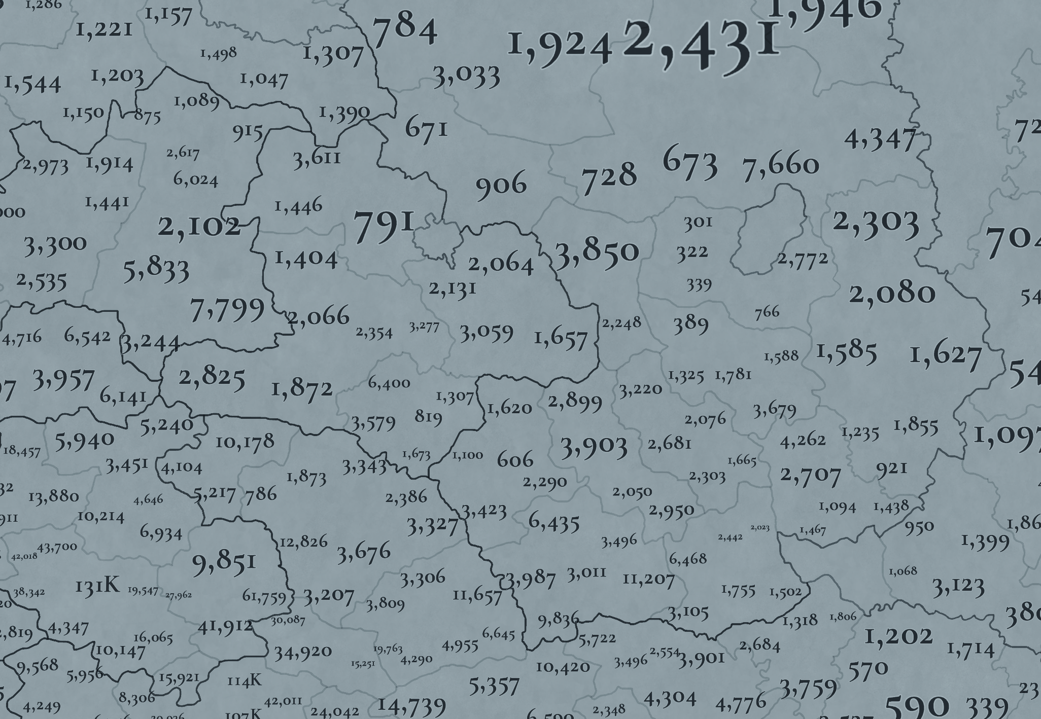
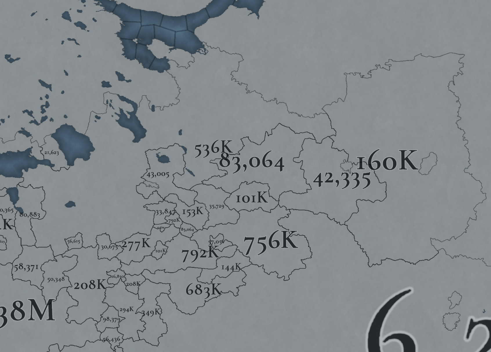
Not many people inhabit the Russian core, approximately 6M in total. This poses a series of challenges regarding the expansion of any Russian country. Also, we've divided into 4 different maps of the location population of the region, to make it possible to visualize. A side note: you might note that the population of NW Novgorod and Karelia is calculated a bit differently. That's because Johan took care of drawing the Scandinavian map in an early stage of development, and the Content Design team took over the rest of Russia at a later stage when we had already refined a bit more our population calculation methods. This means that when we do the feedback pass after this Tinto Maps, in a few weeks, we'll homogenize the style, as well.

And this is all for today! We hope that you’ll find it interesting, and give us great feedback! Next week we’re traveling to Carpathia and the Balkans! See you!
 
  • 158Like
  • 67Love
  • 6
  • 6
  • 5
Reactions:
Is it possible to get a more detailed view of the locations of Ryazan and it's surrounding areas? Something like this perhaps?
IMG_20240718_131749.jpg

Can't read some of the location names am afraid.
 
Is it possible to get a more detailed view of the locations of Ryazan and it's surrounding areas? Something like this perhaps?
Can't read some of the location names am afraid.
The bit around Rostov is shown in post #188.
I'd say the place between Kolomna and Ryazan is Glukhovichi, a small village from about 1600.
A quick googling shows that "Perevitsk" might be more appropriate: it was a fort along the route between Kolomna and Ryasan, and a site of battle between Moscow & Ryasan forces. Ultimately, it was demolished by Ivan the Terrible.
the mistyped Lukhovitsi (Glukhovitsi), Which shouldn't be there, it's too early for them.
UPD: they do feature in English wiki as Glukhovichi from late 1500s.
 
Last edited:
  • 2Like
Reactions:
I see that Östra Götaland/ Östergötland, and Västra Götaland/ Västergötland, still hasn't been fixed. The counties (Landskap), are called Västergötland and Östergötland. They are part of the larger region of Götaland. If you want to refer to regions eastern half, you can say "Östra Götaland", but that's not the same as the county, even if the names mean the same thing. I'm really suprised I have to say this to a Swedish studio (I know the team is Spanish). You'd think some Swede would have seen the map of Scandinavia at some point during development?
You're just in time to post this into the dedicated Scandinavia map topic, opened today Friday.
 
Hello! I just got back from vacation and can’t read the entire discussion. It has already been written here that the map contains many names of cities founded after the 14th century (there is even Belinsky, which is named after a writer of the 19th century)? Other examples are Pestravka (found in 1769 by ethnic Ukrainians, its name itself is Ukrainian), Almetyevsk (misspeled here as Almeryevsk, found in 1720s by Almet the Mullah), Saransk (found in 1641 by Russians, name is non-native). Tutayev was there since 13th century, but under the name of Romanov, because Tutayev himself was... a bolshevik! Etc.
Unlike the names of European locations, which may not have changed names since the Middle Ages, the territory of what is now Russia has undergone significant movements of ethnic groups and changes in city names, so you need to be very careful about how you name provinces here.
 
  • 1
Reactions:
Hello! I just got back from vacation and can’t read the entire discussion. It has already been written here that the map contains many names of cities founded after the 14th century? (there is even Belinsky, which is named after a writer of the 19th century, or Tutayev was there since 13th century, but under the name of Romanov, because Tutayev himself was... a bolshevik! Etc.)
Some of them have already been caught: I recognise Belinsky. Feel free to make another sweep: maybe you would notice something others have missed.
 
Hello! I just got back from vacation and can’t read the entire discussion. It has already been written here that the map contains many names of cities founded after the 14th century (there is even Belinsky, which is named after a writer of the 19th century)? Other examples are Pestravka (found in 1769 by ethnic Ukrainians, its name itself is Ukrainian), Almetyevsk (misspeled here as Almeryevsk, found in 1720s by Almet the Mullah), Saransk (found in 1641 by Russians, name is non-native). Tutayev was there since 13th century, but under the name of Romanov, because Tutayev himself was... a bolshevik! Etc.
Unlike the names of European locations, which may not have changed names since the Middle Ages, the territory of what is now Russia has undergone significant movements of ethnic groups and changes in city names, so you need to be very careful about how you name provinces here.
Saransk - moksha - Saran Oh, or by river - Sarley
 
Filling in the blanks
View attachment 1165746

So as others in this thread have already said, this impassable is bad, nonsensical and worst of all, completely ahistorical. Viena Karelia, also known as White Karelia or East Karelia, was not some uninhabited wasteland. It was populated, relatively important historically and was travelled through by both armies and merchants, as other people have already shown in their posts.

For example, the drainage basin of the Kemi river is in this impassable "wasteland". This river and its tributaries and lakes were used for east-west travel by karelians for centuries. The village of Uhtua, modern day Kalevala, is located in this black space. The lands of the rune-singers, the place where Elias Lönnrot found ancient finnic mythology preserved in oral tradition for many generations.

View attachment 1165748
View attachment 1165749

And it's just erased. I don't really know what happened behind the scenes, but that doesn't really matter. What matters is fixing this, as others have said. But unlike others, I will provide a concrete suggestion of what to put here in this "empty space".

View attachment 1165755

Note that these are just my suggestions. Do your own research. Also note that Alakurtti is a rather modern name, a settlement founded in the 1800s by finns.

Now it's important to note that this area wasn't very settled in 1300s yet. But this was the case for the locations directly west in modern-day Finland too, so I see no reason to make a distinction between them. At game start these lands should be Sami majority like in the west and north, with potential for colonization and settlement that happened historically in the game's time period. Aforementioned Uhtua and the Kuittijärvi area in general were settled in the 1500s by Karelians.
Here is a more detailed source about the settlement of Karelians in Viena, available in swedish so Johan can read it without translation:

EDIT: @Jarzki you posted while I was writing this lol, well the more people post about this the better
Reposting this here as technically Karelia is part of the Russia review.
 
  • 3
  • 1
Reactions:
I have finally finished my feedback for Ingria and Karelia. Hopefully this will be helpful when these areas get reviewed!

As some have already pointed out, the borders in Ingria and Karelia are quite sloppy and inaccurate. This is an issue mainly because a lot of these borders worked as national borders during the timeframe of the game. As there are a lot of inaccuracies with the borders and the locations, I decided that the easiest way to point them all out was to draw my own version of the region with all the fixes and explanations for them.

Historical state and county borders
View attachment 1162212View attachment 1162213

The dark borders are the most important ones to portray. They represent the historical state borders of Sweden and Russia and the historical borders of Swedish counties. The borders are the following:

View attachment 1162194View attachment 1162208
Treaty of Nöteborg (1323)


View attachment 1162195View attachment 1162205
Treaty of Teusina (1595)

View attachment 1162196
Treaty of Stolbovo (1617)

View attachment 1162198View attachment 1162210View attachment 1162211
Treaty of Nystad (1721) and Treaty of Åbo (1743)

View attachment 1162199View attachment 1162200View attachment 1162201View attachment 1162202View attachment 1162204
The borders of the counties of Viborg, Savolax, Kexholm and Ingria. This Wikipedia article and this map are good and detailed references for province borders.

Provinces
View attachment 1162214

The province borders are entirely based on historical counties. The biggest differences are with the counties of Viborg (currently Karelia) and Kexholm (currently Far Karelia). Before the Ingrian war and the Treaty of Stolbovo, the border of Sweden and Russia followed the eastern borders of the counties of Viborg and Savolax. At the time Kexholm Karelia was a subdivision of Vodskaya Pyatina, which itself was one of the five subdivisions of Novgorod Land in Russia. The territory was known as Korelsky Uyezd and it was administered from Korela (Kexholm). When Sweden received the uyezd in the Treaty of Stolbovo alongside Ingria, the borders of the uyezd were preserved and its eastern borders became state borders between Sweden and Russia. To represent this, "Far Karelia" should be given the locations on the western coast of Lake Ladoga, according to the borders of the Kexholm County as they were before and after Swedish conquest. Its name could also be changed to either Kexholm or Korela, while "Karelia" is renamed to Viborg, to match the names of the historical counties.

Another important difference is that Kajana is left outside Savolax, as historically Kajana was part of Ostrobothnia.

Countries
View attachment 1162215

Sweden should be given more land in Savonia and Karelia according to the Treaty of Nöteborg. I have a more detailed explanation of what areas Sweden and Oreshek should own in 1337 in my Map of Finland thread. Oreshek is also currently missing territory. In 1333, in addition to Korela and Oreshek, which Oreshek currently own in-game, Narimantas also received Ladoga and "half of Koporye". I haven't unfortunately found any information about what "half of Koporye" means precisely. Oreshek should also be given the northern coast of Lake Ladoga, as Novgorod also ruled over so called Ladoga Karelia as part of Karelia. (More detailed explanation in my my thread.) I'm not sure how far north in Korela Novgoridian authority reached in 1337 or how it should be represented in game. The non-coastal parishes are known to have been settled in the 15th century (Kitee, Suojärvi, Ilomantsi). Many maps that represent the time period show all of Korela as part of Novgorod, but this is most likely anachronistic. The situation is complicated by Novgorod claiming all of northern Finland all the way up to the Bothnian Bay for itself according to the Nöteborg treaty, but Sweden slowly colonialized the area anyway.

It is also important to note that Narimantas's son Patrikas controlled even more territory than his father, practically all of Vodskaya Pyatina.

Locations
View attachment 1162217

Many locations have been changed and renamed to be more historical. I tried to match the density of the original locations, but I don't know if the devs are planning on increasing the density. The names are all in Finnish for consistency. Most information is from Finnish, Swedish and Russian Wikipedia. The main map used as reference is this map of administrative counties in 1635, which is based on maps from 1959 Atlas of Finnish History by Eino Jutikkala. Maps from savonhistoria.fi were also used as reference, mainly this map showcasing Savonian church parish borders in 1618 and 1635 and this map of Savonian parish borders in 1870, which I used as reference for splitting apart Iisalmi and Kuopio. Ingrian locations utilize this map of 17th century Ingria from This blog post has a more detailed version of the map, but unfortunately it doesn't tell where the map is from. This book has information about Finnish and Swedish congregations in Ingria, which I used as a source for Swedish names of Ingrian parishes. Explanations for the locations alongside names in different languages are available in the spoilers below. Russian names are both in Latin and Cyrillic, in case the romanizations have errors or Paradox prefers to use another romanization standard.

FinnishSwedishRussianNotes
JääskiJäskisYaski, Yaaski or Yaskis (Яски, Яаски or Яскис)Moved to a more historical position. Replaces Heinjoki, which only became independent from the municipality of Muolaa in 1869.
KivennapaKivinebbKivennapa or Kivinebb (Ки́веннапа or Кивинебб)Replaces Valkeasaari, which is in Ingria and not former Swedish Karelia.
LappeenrantaVillmanstrandLappeenranta or Vilmanstrand (Лаппеэнранта or Вильманстранд)Could also be called Lapvesi (Lappvesi), as the city of Lappeenranta was only established in 1649. I don't think this is needed, however, as the name Lappeenranta doesn't reference any 17th century person and the name would only be inaccurate for half of the game.
MuolaaMolaMuolaa (Муолаа)Replaces Kyyrölä, which only became an independent municipality in 1890. Also has an older Swedish name Mohla.
PyhtääPyttisPyukhtya, Pyukhtyaa or Pyuttis (Пюхтя, Пю́хтяа or Пю́ттис)Replaces Kotka, which was only established in 1879.
RuokolahtiRuokolaxRuokolakhti (Руоколахти)Replaces current Jääski (Jäskis), which is too far north.
SavitaipaleSavitaipaleSavitaypale (Савитайпале)Replaces Kouvola, which only started developing in the 1870s and became an independent municipality in 1922.
UusikirkkoNykyrkaUusikirkko (Уусикиркко)
VehkalahtiVeckelaxVekhkalakhti or Vekelaks (Вехкалахти or Векелакс)Could also be called Hamina (Swe. Fredrikshamn, Rus. Khamina or Fridrikhsgam (Ха́мина or Фридрихсгам)), like its currently named. The name comes from the 18th century King Fredrik I, so it would be nonsensical for most of the game.
ViipuriVyborgVyborg (Выборг)Ideally the borders of Vyborg should follow historical parish borders like shown in the map. This is because in 1493 John, King of Denmark, allied with Grand Prince Ivan to pressure the Swedish regent Sten Sture the Elder to acknowledge John's sovereignty over Sweden under the Kalmar Union. He promised that if Ivan was able to take control of Sweden, the border of the Treaty of Nöteborg would be restored. According to Savon historia, in 1501 the Russians revealed John's promises to have been larger, promising to restore the borders predating the Nöteborg treaty. This would mean losing the parishes of Jääski, Äyräpää and Savilahti to Moscow according to their old borders. This means all of Savonia and the eastern parts of the Viborg province, with Viborg remaining part of Sweden. According to historian Kyösti Julku in his book Suomen itärajan synty, the pre-Nöteborg border very closely followed the borders of the Viborg parish in the 17th century. So if the restoration of this border happened in an alt-history scenario, the eastern border of Vyborg would form the border between Sweden and Moscow in Karelia.
VirolahtiVederlaxVirolakhti or Vederlaks (Ви́ролахти or Ведерлакс)

The Karelian names are pretty uncertain, as I was uable to find any good consistent sources for them. Karelian place names seem to be dependent on dialect and I'm not sure if the Karelian names on Wikipedia are even from the same dialect.

FinnishKarelianSwedishRussianNotes
IlomantsiIl’manči or IlomanččiIlomantsIlomantsi (Иломантси)Moved east to replace Möhkö, as that's where the center of the parish and the lake the parish is named after is situated.
JuukaJugaYuuka (Юука)
KiteeKidesKityaga (Китьяга)
KontiolahtiKontiolaxKontiolakhti (Контиолахти)
KurkijokiKronoborgKurkiyoki (Куркиёки)Replaces Lahdenpohja, as Lahdenpohja wouldn't become independent until 1924.
KäkisalmiKägöisalmiKexholmKorela (Коре́ла)
LiperiLibelitsLiperi (Липери)Replaces Joensuu, as Joensuu was only a village that was part of Kontiolahti during the game's timeframe. On the other hand, the parish of Liperi has existed since 1630.
NurmesNurmesNurmes (Нурмес)
PielisjärviPielisjärviPielisyarvi (Пиелисъярви)Replaces Lieksa, as Lieksa belonged to the parish of Pielisjärvi during the game's timeframe.
SakkulaSakkulaSakkulaSakkula (Саккула)Replaces Konevets, as Konevets is merely an island near the coast, though the monestary on the island is noteable and old.
SalmiSalmiSalmisSolomyane (Соломяне)The modern Russian name is Салми (Salmi), but, according to the Russian Wikipedia page for Salmi, it was originally Соломенский погост (Solomensky pogost). However, Solomensky is an adjective. Google translate is a bit weird sometimes, but it seems the proper name is Соломяне (Solomyane). This source seems to agree.
SortavalaSortavalaSordavalaSerdobol (Сердоболь)
SuistamoSuistamoSujstamoSuystamo (Суйстамо)The territories of Loimola (Loymola) are given to Suistamo and Suojärvi, as Loimola only became a municipality in 2006.
SuojärviSuojärviSuojärviSuoyarvi (Суоярви)
TohmajärviTohmajärviTokhmayarvi (Тохмаярви)Replaces Värtsilä, which was part of Tohmajärvi until 1920.
UukuniemiUguniemiUukuniemi (Уукуниеми)

FinnishSwedishRussianNotes
IisalmiIdensalmiIysalmi (И́йсалми)
JoroinenJoroisYoroynen or Yoroys (Йоройнен or Йоройс)
JuvaJockasYuva (Ю́ва)Replaces Ristiina, as Juva is one of the oldest parishes in Savonia, while Ristiina was established only in 1649 and it was named after a contemporary person, Kristina, the wife of Count Per Brahe the Younger.
KangasniemiKangasniemiKangasniemi (Кангасниеми)
KerimäkiKerimäkiKerimyaki (Керимяки)Replaces Savonranta, as Kerimäki is the older parish in the area (Kerimäki became a parish in 1642 while Savonranta became independent in 1868).
KuopioKuopioKuopio (Ку́опио)
LeppävirtaLeppävirtaLeppyavirta (Леппявирта)I made the western borders of Leppävirta follow Russian border demands from 1500 because plausible alt-history is cool.
MikkeliS:t MichelSankt-Mikhel (Санкт-Михель)
NilsiäNilsiäNilsiya (Нильсия)According to nilsia.fi Nilsiä was mentioned as a wilderness area in a 1561 tax list.
PieksämäkiPieksämäkiPieksyamyaki (Пиексямяки)
PielavesiPielavesiPielavesi (Пиелавеси)Existed as a chapelry since 1683 and became an independent parish in 1811.
SavonlinnaNyslottNeyshlot (Нейшлот)Replaces Olavinlinna (Olofsborg), which is the name of a castle, while Savonlinna (Nyslott) is the name of the city built around the castle. The location is situated on the eastern side of the Nöteborg border, as during construction of the castle the Russians complained that the castle was being built on their side of the border. They also demanded for the castle to be ceded to them before the First Russian-Swedish war.
SääminkiSämingeSyaaminki (Сяаминки)

FinnishEstonianSwedishGermanRussianNotes
HatsinaHottšino (Earlier) or Gattšina (Later)Gattjina (Later)Gattschina (Later)Khotchino (Earlier) or Gatchina (Later) (Хотчино or Га́тчина)Known since 1499. Originally the name started with an h sound, but around the middle of the 17th century, it was replaced with a g sound. I wasn't able to find the old version of the name in Swedish.
IivananlinnaJaanilinnIvangorodJohannstadt or IwangorodIvangorod (Ивангород)A prominent castle built by and named after Ivan III in 1492, with a town of the same name associated with it. I think it would be crucial to have in the game, though the name could cause some difficulties.
InkereInkereIngrisIzhora (Ижора)Replaces Liissilä, as in 1612, before Swedish rule, Liissilä was a village in the Izhora pogost.
JaamaJaamaJamaJamaYam or Yama (Ям or Я́ма)Moved east to the position of Moloskovits to match the borders of the historical Jama län and to make space for Ivangorod.
KaprioKoporjeKoporjeKoporjeKoporye (Копо́рье)
LoppiLoppisLoppi (Лоппи)Replaces Markkova, as Loppi is the old name of the parish. During the Great Northern War the original Lutheran church of Loppi was burned down. In 1722, a new one was built in Markkova, which is where the parish got its new name from.
NevanlinnaNyenNyenNyenNiyen (Ниен)
PähkinälinnaNöteborgNöteborgOreshek (Оре́шек)
SoikkolaSoikinaSoikino (Со́йкино)
ToksovaToksovoToksovoToksovo (То́ксово)
TuutariTuutariDuderhofDudergof (Дудергоф)Replaces Tyrö, as Tuutari as a parish is two years older and maps show Tyrö as a subdivision of Tuutari.

Additional feedback
View attachment 1162219

Fulmen had a good point about the wasteland in White Karelia. Many raids were carried out over this area historically, making its representation as a wasteland problematic. This area was historically known as Forest Lapland, Novgorod Lapland or Лопские погосты (Lop' pogosts). It was formed as an administrative entity by Ivan III at the end of the 15th century and in 1650 they were transferred from the Novgorodsky Uyezd to the Olonetsky Uyezd. In game the Lop' pogosts could maybe either be part of White Karelia or form their own province. This article has good maps of the area from different years in both Russian and Finnish. Also, the border against Finland regardless if the area is a wasteland or not should definitely follow the historical border set in the Treaty of Teusina. My Finland thread has a detailed explanation of this too.

The romanization of Russian place names seems to be inconsistent. In English the j sound is usually romanized as y (й = y not j, ю = yo not jo, я = ya not ja) to be more intuitive for English speakers. Currently there are some places romanized with y such as Plyussa while some are romanized with j, such as Koporje (in Wikipedia its Koporye). There are many romanization systems for Russian, and I'm not an expert on them or which ones is the most popular, but it would be good for the romanization system to be consistent in game.

Nice work. I wish I had the energy to do such an extensive post.

A couple of minor nitpicks or additions:

Post-1617 maps tend to always draw the Korela Uyezd, i.e. Käkisalmen lääni, Kexholms län, with its post-Treaty of Stolbovo borders, which is the case in the maps you posted as well. In reality the Uyezd was larger. Specifically, it also included Repola, which was a part of the Ilomantsi Greater Pogost (suurpogosta) (e.g. the 1571 Ilomantsi Pogost tax book mentions taxes being collected from the villages of Repola, Luovutsaari and Roukkula in the area of what later became Repola Pogost).

"The earliest mentions of Repola are in the 1555 Korelan Nousia Rydzin's account and in the 1571 Greater Pogost of Ilomantsi's tax book about the villages of Repola, Luovutsaari and Roukkula. The Swedes stated that in 1593 the Repola area contained 166 houses."[1]

Meanwhile Porajärvi and its surrounding lands belonged to the Valamo Monastery. Both villages and their surrounding areas were a part of the Korela Uyezd and should have been handed over to Sweden in the 1617 Treaty of Stolbovo. The Russians disagreed, claiming that because Repola had mostly paid taxes to Kola rather than Korela, and Porajärvi to Novgorod (note that even the Russians' own tax lists showed that Porajärvi paid taxes to Valamo, which the Swedes knew as they had captured such a list from the City of Novgorod, so I'm not sure what this claim was based on), that these territories were ancient Russian land and thus not a part of the Korela Uyezd. This also despite the populations of the villages wanting to join Sweden. Repola itself was already controlled by Sweden, I forget what Porajärvi's de facto status was at the time. The Russians were unwilling to compromise and border negotiations at times almost led to violent clashes, and eventually Sweden's King Gustav II Adolf relented that it's not worth keeping the border with the Russians undecided when there simultaneously was a threat from Poland's direction in the south (Livonia etc.), and ceded the two territories.[2] It is only then that the Korela Uyezd, now Kexholms län (Käkisalmen lääni), received the borders always drawn on maps.

This is my approximation of the northern-northeastern border of the pre-Treaty of Stolbovo Korela Uyezd[3]. There were also some modifications made to it in the southeast, giving birth to the Hyrsylä Bend. My understanding is that before Stolbovo the Uyezd's border ran fairly straight from Lake Unusjärvi to Lake Ladoga. I don't know this but it would not surprise me if the southeastern border of the Uyezd had been all the way at the Tuulos river. It is the closest larger river in the area, after all.

Korela_Uyezd.png

The second nitpick is this other anachronistic tendency in 20th and 21st century maps: drawing the southernmost Finnish border (and thus also pre-1617 Swedish) on the 1864 Rust Ditch border. This is a mistake far smaller than the anachronism with the Korela Uyezd, but it's nonetheless very noticeable to the trained eye, so to speak.

Before Peter the Great dammed the Siestarjoki (Systerbäck, Sestra) river in the early 18th century, the river made this kind of U-shaped loop into the south, and so did the Finnish border, which was situated on the river. The river itself flowed into the sea on the same spot it flows into the sea now. Damming the river created the artificial Lake Sestroretsk (Siestarjärvi), which then led to several alterations of the Finnish border during Tsarist rule over Finland (1809-1917) until settling on the 1864 border on the Rust Ditch (itself dug IIRC in 1839), which lasted until WW2. Most 20th and 21st century maps depicting Swedish Finland tend to anachronistically display the 1864 border as the southern border, when in reality it ran several km to the south of that. Moreover, it ran all the way to Retusaari Island, modern-day Kotlin Island, cutting it in half, at least since the very early 1400s, possibly before.[4]

Here's an illustration of the border changes on the Siestarjoki and its immediate area. Excuse the Google-translated Russian.[5]

1721646960904.png


Here's the border to Retusaari. This remained the border of Viborg Province until c. 1721 as well. Of course pre-1617 it didn't continue southwest to Ingria the way it does in the map below, but rather continued directly west into the sea after the island.

1721647054691.png


[1]Leo Homanen (2005): Repolan historiaa vuoteen 1939 ja Homasen suvun vaiheita [The History of Repola to 1939 and Events of the Homanen Dynasty], p. 2.

1721645033152.png

[2]For a slightly more comprehensive breakdown of the negotiations and their events, see: Helge Seppälä (1994): Vuosisatainen taistelu Karjalasta [The Centuries-long Battle for Karelia], pp. 29-30.

1721645135496.png1721645167005.png

[3]Based on the old border of the Uyezd as told by the inhabitants of the area, see Karjalan Heimo 7-8/1990, p. 132.

1721645229027.png

[4]See also Kyösti Julku (1987): Suomen itärajan synty [The Birth of Finland's Eastern Border], p. 215. Though ironically Julku's book also has the 1864 Rust Ditch anachronism I talked about.

[5]From a great Russian webpage detailing the history of the river. The website itself also has many goodies in the form of historical maps and information, I recommend checking it out. https://www.aroundspb.ru/history/syster/syster.php
 
Last edited:
  • 4Love
  • 2Like
  • 2
Reactions:
Nice work. I wish I had the energy to do such an extensive post.

A couple of minor nitpicks or additions:

Post-1617 maps tend to always draw the Korela Uyezd, i.e. Käkisalmen lääni, Kexholms län, with its post-Treaty of Stolbovo borders, which is the case in the maps you posted as well. In reality the Uyezd was larger. Specifically, it also included Repola, which was a part of the Ilomantsi Greater Pogost (suurpogosta) (e.g. the 1571 Ilomantsi Pogost tax book mentions taxes being collected from the villages of Repola, Luovutsaari and Roukkula in the area of what later became Repola Pogost).

"The earliest mentions of Repola are in the 1555 Korelan Nousia Rydzin's account and in the 1571 Greater Pogost of Ilomantsi's tax book about the villages of Repola, Luovutsaari and Roukkula. The Swedes stated that in 1593 the Repola area contained 166 houses."[1]

Meanwhile Porajärvi and its surrounding lands belonged to the Valamo Monastery. Both villages and their surrounding areas were a part of the Korela Uyezd and should have been handed over to Sweden in the 1617 Treaty of Stolbovo. The Russians disagreed, claiming that because Repola had mostly paid taxes to Kola rather than Korela, and Porajärvi to Novgorod (note that even the Russians' own tax lists showed that Porajärvi paid taxes to Valamo, which the Swedes knew as they had captured such a list from the City of Novgorod, so I'm not sure what this claim was based on), that these territories were ancient Russian land and thus not a part of the Korela Uyezd. This also despite the populations of the villages wanting to join Sweden. Repola itself was already controlled by Sweden, I forget what Porajärvi's de facto status was at the time. The Russians were unwilling to compromise and border negotiations at times almost led to violent clashes, and eventually Sweden's King Gustav II Adolf relented that it's not worth keeping the border with the Russians undecided when there simultaneously was a threat from Poland's direction in the south (Livonia etc.), and ceded the two territories.[2] It is only then that the Korela Uyezd, now Kexholms län (Käkisalmen lääni), received the borders always drawn on maps.

This is my approximation of the northern-northeastern border of the pre-Treaty of Stolbovo Korela Uyezd[3]. There were also some modifications made to it in the southeast, giving birth to the Hyrsylä Bend. My understanding is that before Stolbovo the Uyezd's border ran fairly straight from Lake Unusjärvi to Lake Ladoga. I don't know this but it would not surprise me if the southeastern border of the Uyezd had been all the way at the Tuulos river. It is the closest larger river in the area, after all.

View attachment 1166485

The second nitpick is this other anachronistic tendency in 20th and 21st century maps: drawing the southernmost Finnish border (and thus also pre-1617 Swedish) on the 1864 Rust Ditch border. This is a mistake far smaller than the anachronism with the Korela Uyezd, but it's nonetheless very noticeable to the trained eye, so to speak.

Before Peter the Great dammed the Siestarjoki (Systerbäck, Sestra) river in the early 18th century, the river made this kind of U-shaped loop into the south, and so did the Finnish border, which was situated on the river. The river itself flowed into the sea on the same spot it flows into the sea now. Damming the river created the artificial Lake Sestroretsk (Siestarjärvi), which then led to several alterations of the Finnish border during Tsarist rule over Finland (1809-1917) until settling on the 1864 border on the Rust Ditch (itself dug IIRC in 1839), which lasted until WW2. Most 20th and 21st century maps depicting Swedish Finland tend to anachronistically display the 1864 border as the southern border, when in reality it ran several km to the south of that. Moreover, it ran all the way to Retusaari Island, modern-day Kotlin Island, cutting it in half, at least since the very early 1400s, possibly before.[4]

Here's an illustration of the border changes on the Siestarjoki and its immediate area. Excuse the Google-translated Russian.[5]

View attachment 1166499

Here's the border to Retusaari. This remained the border of Viborg Province until c. 1721 as well. Of course pre-1617 it didn't continue southwest to Ingria the way it does in the map below, but rather continued directly west into the sea after the island.

View attachment 1166500

[1]Leo Homanen (2005): Repolan historiaa vuoteen 1939 ja Homasen suvun vaiheita [The History of Repola to 1939 and Events of the Homanen Dynasty], p. 2.

View attachment 1166487

[2]For a slightly more comprehensive breakdown of the negotiations and their events, see: Helge Seppälä (1994): Vuosisatainen taistelu Karjalasta [The Centuries-long Battle for Karelia], pp. 29-30.

View attachment 1166488View attachment 1166490

[3]Based on the old border of the Uyezd as told by the inhabitants of the area, see Karjalan Heimo 7-8/1990, p. 132.

View attachment 1166491

[4]See also Kyösti Julku (1987): Suomen itärajan synty [The Birth of Finland's Eastern Border], p. 215. Though ironically Julku's book also has the 1864 Rust Ditch anachronism I talked about.

[5]From a great Russian webpage detailing the history of the river. The website itself also has many goodies in the form of historical maps and information, I recommend checking it out. https://www.aroundspb.ru/history/syster/syster.php
Very interesting. I had no idea the 20th century Repola and Porajärvi had a historical basis. The historical northern Korela Uyezd border could definitely be used for a Repola location, but I'm not sure if Repola should be part of Kexholm in the game. If you wanted to draw the Stolbovo borders historically, it would mean that Repola would just awkwardly be an isolated Kexholm province while the rest of Kexholm is part of Sweden. Though a similar thing would happen if Repola was part of White Karelia or something. If Sweden were to take all of the historical Korela Uezd then Repola would be an isolated White Karelia location. I'm fine with either way, as long as the rest of the locations are drawn according to the Treaty of Stolbovo border. In my opinion historical state borders should be prioritized over administrative divisions.

I wonder if Valamo/Valaam should be its own location actually. It seemed to be pretty important for Karelia's christinization and administration. It has also been attacked multiple times during war. The island is pretty small, but maybe it could be exaggerated a little on the map, unless Paradox has an absolute no exaggerated islands policy for this game. I also wonder if it's possible for there to even be a location in the middle of a lake, as lakes probably aren't navigable like seas.
1721752767607.png
 
  • 3Like
Reactions:
I wonder if Valamo/Valaam should be its own location actually. It seemed to be pretty important for Karelia's christinization and administration. It has also been attacked multiple times during war. The island is pretty small, but maybe it could be exaggerated a little on the map, unless Paradox has an absolute no exaggerated islands policy for this game. I also wonder if it's possible for there to even be a location in the middle of a lake, as lakes probably aren't navigable like seas.
It’s like half the size of San Marino and San Marino won’t be on the map. Not a chance in hell.
 
  • 3
Reactions:
Very interesting. I had no idea the 20th century Repola and Porajärvi had a historical basis. The historical northern Korela Uyezd border could definitely be used for a Repola location, but I'm not sure if Repola should be part of Kexholm in the game. If you wanted to draw the Stolbovo borders historically, it would mean that Repola would just awkwardly be an isolated Kexholm province while the rest of Kexholm is part of Sweden. Though a similar thing would happen if Repola was part of White Karelia or something. If Sweden were to take all of the historical Korela Uezd then Repola would be an isolated White Karelia location. I'm fine with either way, as long as the rest of the locations are drawn according to the Treaty of Stolbovo border. In my opinion historical state borders should be prioritized over administrative divisions.

I wonder if Valamo/Valaam should be its own location actually. It seemed to be pretty important for Karelia's christinization and administration. It has also been attacked multiple times during war. The island is pretty small, but maybe it could be exaggerated a little on the map, unless Paradox has an absolute no exaggerated islands policy for this game. I also wonder if it's possible for there to even be a location in the middle of a lake, as lakes probably aren't navigable like seas.
View attachment 1167009

The game's Korela Uyezd/Kexholms län/Käkisalmen lääni should follow what it historically became in 1621, provided of course that states and provinces function the way we're used to them functioning in other PDX games. I simply wanted to point out that actually prior to 1621 the province was larger, which is never correctly portrayed in later maps. There's even a well-known Russian map from the 19th century about Novgorod's five pyatinas that anachronistically portrays the Votian Pyatina and therefore the Korela Uyezd based on post-1621 borders of the latter. Like the changes to the Finnish border on the Siestarjoki/Systerbäck, and Retusaari Island for that matter, this topic is poorly known, so I wanted to mention it.

As for the monasteries, it'd be sensible to show their historical influence in some way. The Solovetsky Monastery for instance "governed" (more like collected taxes and practiced conversion work, I guess) wide parts of the White Sea coasts for centuries, and if memory serves there were also monasteries in some other places like Kola (the settlement), Petsamo (destroyed by a Finnish war party in 1589), and of course there was the Valamo Monastery on Valamo Island as you pointed out, etc.
 
  • 2
Reactions:
LOWrus.png

[updated]
Well, it's been a month since the DD, which means it's time to post my total conversion of the former Vladimir-Suzdal!
@Pavía , I hope it’s not too late to send you my feedback?
Work is in progress, and here is a few major changes:
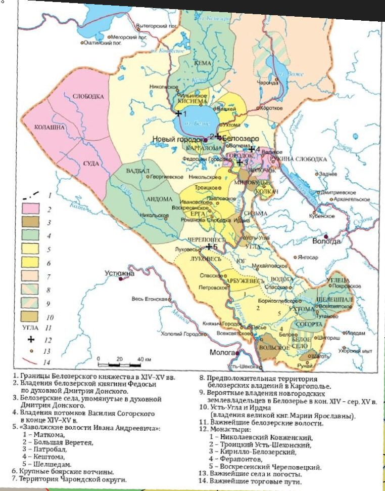
1. Borders of principalities are brought in conformity with a number of known maps of Northwest Russia of those years. In particular, I was inspired by the works of the famous Belarusan historian Viktor Temushev. He carefully collected and categorized information about territorial changes in the region, thanks to which his maps are unusually detailed and, I am sure, as accurate as possible.
2. The names of many locations have been double-checked and replaced with more historically appropriate names. The work is still in progress, so not all names are spelled out.
3. The Vladimir principality was not yet firmly incorporated into Moscow in 1337. Ivan Kalita was Prince of Moscow and at the same time Grand Prince of Vladimir, one could say on the rights of personal union. By the end of his life his power was quite large (as is often the case in CK), but it took some time to inherit Vladimir. For a while Vladimir was even omitted by Moscow in favor of Novgorod-Suzdal, so I think it would be correct to portray Vladimir as a junior uniate in the struggle between the principalities.
4. Many Russian principalities colonized lands in the North, and in addition to Rostov, Dmitrov, etc., Yaroslavl had such an exclave. It was called Zaozerie, and it is shown on the map.
5. Despite the conflicting sources of Vyatka and the Mari principalities, these historical entities definitely existed at the same time and place. I still suspect that the Mari legends exaggerate the devastation inflicted on Vyatka, plus the Vyatka river pirates-ukshuyniks made repeated raids, so I'd like to see Vyatka and the Mari principalities side by side and rivalry

And next I'll chow you changes in the location map at this moment:

LOWrusloc.png

Your map turned out pretty accurate and elaborate, and because I respect your glorious work, I tried to make as few changes as possible, following location boundaries wherever possible. I overlaid two location maps on top of each other; the borders that match are in black, the ones I corrected are in red. Also, I didn't have a river map in front of me, but I needed them to orient the small maps of the principalities, so I had to reconstruct them too, to make the map as accurate and precise as possible.

And at the end my vision of the diplomatic map of Moscow for 1337, with all the union members and vassals (Beloozero was bought by Kalita, but will be taken away by the Golden Horde)
LOWrusdip2.png


Снимок экрана 2024-07-29 162942.png

Beloozero

Снимок экрана 2024-07-24 152834.png

Galich (Dmitrovian vassal)

Снимок экрана 2024-07-29 163000.png

Uglich

NErus_1360.jpg

former Vladimir-Suzdal, Ryazan and Verkhovie principalities

tver.jpg

Tver and it’s neighbours

Снимок экрана 2024-07-29 163453.png

Yaroslavl

Снимок экрана 2024-07-29 163311.png

Starodub

Снимок экрана 2024-07-29 163323.png

Principality of Yuryev-Polsky

Снимок экрана 2024-07-29 163405.png

Verkhovian principalities and Lithuanian vassals

Снимок экрана 2024-07-29 163025.png

Moscow-Ryazanian border after ceising Serpukhov, Kashira and Kolomna
 
Last edited:
  • 11Love
  • 10Like
  • 1
  • 1
  • 1
Reactions:
Hello everyone! I looked closely at the map from Tinto Talk and found many names that do not correspond to the era and culture. I made a table in which in the first column is the location name on the original map, in the second column is the new name I proposed, in the third column is the name that the location should receive only after being received by a country with a predominant Russian culture. In the following columns I give a brief explanation. In the last column I have put here and there the name of the country which, in my opinion, should have possessed this province in 1337. This table does not pretend to be complete, because I could have missed something (there are so many locations...)
The locality boundaries look weird in places. But because they are so small, I don't think anything should be changed, because it will look fine on a larger scale. However, there are two fundamental things I disagree with the original map. The first is the enormous size of Perm, and its very existence in 1337. Look at this map:
14CENTURY.png


In the 14th century, these lands directly belonged to Novgorod. Of the territory designated on the original map as Perm, the northern and eastern parts were completely undeveloped, and the southern part was part of the Horde. The Perm Principality emerged in 1451 as a vassal of the Moscow. The exact reason why these lands ceased to be Novgorod lands is unknown, but it can be assumed that this process was connected with the general decline of Novgorod and was relatively bloodless.
The second thing I don't agree with is the inclusion of all lands west of the Urals into either the Horde or some Russian principality. Many Volga territories where Finno-Ugric peoples lived were not controlled by Russian principalities or the Horde. On the map below I have marked the localities that I propose to make uncolonized at the beginning of the game with a yellow circle.
Another small detail is the Novgorod colonization of the Kola Peninsula. According to the latest archaeological data, already at the beginning of the 14th century, settlements with churches appeared on the southern shore of the Kola Peninsula, which indicates a permanent colony here. To reflect this in the game, I propose giving Novgorod one location, where these archaeological finds were made.

1337.png
 

Attachments

  • EU5.xlsx
    19,9 KB · Views: 0
  • 6Like
  • 1
Reactions:
View attachment 1169551
Well, it's been a month since the DD, which means it's time to post my total conversion of the former Vladimir-Suzdal!
@Pavía , I hope it’s not too late to send you my feedback?
Work is in progress, and here is a few major changes:
1. Borders of principalities are brought in conformity with a number of known maps of Northwest Russia of those years. In particular, I was inspired by the works of the famous Belarusan historian Viktor Temushev. He carefully collected and categorized information about territorial changes in the region, thanks to which his maps are unusually detailed and, I am sure, as accurate as possible.
2. The names of many locations have been double-checked and replaced with more historically appropriate names. The work is still in progress, so not all names are spelled out.
3. The Vladimir principality was not yet firmly incorporated into Moscow in 1337. Ivan Kalita was Prince of Moscow and at the same time Grand Prince of Vladimir, one could say on the rights of personal union. By the end of his life his power was quite large (as is often the case in CK), but it took some time to inherit Vladimir. For a while Vladimir was even omitted by Moscow in favor of Novgorod-Suzdal, so I think it would be correct to portray Vladimir as a junior uniate in the struggle between the principalities.
4. Many Russian principalities colonized lands in the North, and in addition to Rostov, Dmitrov, etc., Yaroslavl had such an exclave. It was called Zaozerie, and it is shown on the map.
5. Despite the conflicting sources of Vyatka and the Mari principalities, these historical entities definitely existed at the same time and place. I still suspect that the Mari legends exaggerate the devastation inflicted on Vyatka, plus the Vyatka river pirates-ukshuyniks made repeated raids, so I'd like to see Vyatka and the Mari principalities side by side and rivalry

And next I'll chow you changes in the location map at this moment:

View attachment 1169548
Your map turned out pretty accurate and elaborate, and because I respect your glorious work, I tried to make as few changes as possible, following location boundaries wherever possible. I overlaid two location maps on top of each other; the borders that match are in black, the ones I corrected are in red. Also, I didn't have a river map in front of me, but I needed them to orient the small maps of the principalities, so I had to reconstruct them too, to make the map as accurate and precise as possible.

And at the end my vision of the diplomatic map of Moscow for 1337, with all the union members and vassals (Beloozero was bought by Kalita, but will be taken away by the Golden Horde)
View attachment 1169550


Bonus: some maps used in that work:

View attachment 1169534
Beloozero

View attachment 1169535
Galich (Dmitrovian vassal)

View attachment 1169537
Uglich

View attachment 1169544
former Vladimir-Suzdal, Ryazan and Verkhovie principalities

View attachment 1169543
Tver and it’s neighbours

View attachment 1169539
Yaroslavl

View attachment 1169540
Starodub

View attachment 1169542
Principality of Yuryev-Polsky

View attachment 1169546
Verkhovian principalities and Lithuanian vassals

View attachment 1169538
Moscow-Ryazanian border after ceising Serpukhov, Kashira and Kolomna
Excellent work. There are only a number of additions
1. Vladimir should be in the Union conditionally. And somehow mechanically pass to the one who has the title of the Grand Duke of Vladimir.
It's like Paris for France)

2. Tula and Yelets are not in the Tatar possessions. It's just that the output from this region went to the income of the wife of the Great Khan directly, without an intermediary in the person of the Grand Duke of Vladimir.
Yelets had its own principality before Tamerlane. Perhaps Yelets should be included in Novosil-Odoev - one dynasty.
and Tula should be given to Ryazan.

3. The northern bank of the Volga in the Nizhny Novgorod region - not the Chuvash, but the Mari - the same as in Vetluga and Sharanga.
Also, the Chuvash on the northern bank of the Volga should be made vassals of the Horde and not its ulus.
There were not a large number of Tatars there, as on the southern bank in Narovchat.

4. Lithuania in 1337 had not yet captured the territory below Smolensk to border Chernigov region.

5. In 1337 Nizhny Novgorod was in Moscow's possession.

6. Did you specifically not consider Karelia?
 
  • 3Like
Reactions:
View attachment 1169551
Well, it's been a month since the DD, which means it's time to post my total conversion of the former Vladimir-Suzdal!
@Pavía , I hope it’s not too late to send you my feedback?
Work is in progress, and here is a few major changes:
1. Borders of principalities are brought in conformity with a number of known maps of Northwest Russia of those years. In particular, I was inspired by the works of the famous Belarusan historian Viktor Temushev. He carefully collected and categorized information about territorial changes in the region, thanks to which his maps are unusually detailed and, I am sure, as accurate as possible.
2. The names of many locations have been double-checked and replaced with more historically appropriate names. The work is still in progress, so not all names are spelled out.
3. The Vladimir principality was not yet firmly incorporated into Moscow in 1337. Ivan Kalita was Prince of Moscow and at the same time Grand Prince of Vladimir, one could say on the rights of personal union. By the end of his life his power was quite large (as is often the case in CK), but it took some time to inherit Vladimir. For a while Vladimir was even omitted by Moscow in favor of Novgorod-Suzdal, so I think it would be correct to portray Vladimir as a junior uniate in the struggle between the principalities.
4. Many Russian principalities colonized lands in the North, and in addition to Rostov, Dmitrov, etc., Yaroslavl had such an exclave. It was called Zaozerie, and it is shown on the map.
5. Despite the conflicting sources of Vyatka and the Mari principalities, these historical entities definitely existed at the same time and place. I still suspect that the Mari legends exaggerate the devastation inflicted on Vyatka, plus the Vyatka river pirates-ukshuyniks made repeated raids, so I'd like to see Vyatka and the Mari principalities side by side and rivalry

And next I'll chow you changes in the location map at this moment:

View attachment 1169548
Your map turned out pretty accurate and elaborate, and because I respect your glorious work, I tried to make as few changes as possible, following location boundaries wherever possible. I overlaid two location maps on top of each other; the borders that match are in black, the ones I corrected are in red. Also, I didn't have a river map in front of me, but I needed them to orient the small maps of the principalities, so I had to reconstruct them too, to make the map as accurate and precise as possible.

And at the end my vision of the diplomatic map of Moscow for 1337, with all the union members and vassals (Beloozero was bought by Kalita, but will be taken away by the Golden Horde)
View attachment 1169550


Bonus: some maps used in that work:

View attachment 1169534
Beloozero

View attachment 1169535
Galich (Dmitrovian vassal)

View attachment 1169537
Uglich

View attachment 1169544
former Vladimir-Suzdal, Ryazan and Verkhovie principalities

View attachment 1169543
Tver and it’s neighbours

View attachment 1169539
Yaroslavl

View attachment 1169540
Starodub

View attachment 1169542
Principality of Yuryev-Polsky

View attachment 1169546
Verkhovian principalities and Lithuanian vassals

View attachment 1169538
Moscow-Ryazanian border after ceising Serpukhov, Kashira and Kolomna
Chuvash people lived on the other side of the river. On what info have you based your placement of them?

Why Nizhnii Novgorod is a vassal of Golden Horde?

Also, I think there is no definite proof that Bolgar ulus was autonomous and not regular administrative division.
 
Chuvash people lived on the other side of the river. On what info have you based your placement of them?

Why Nizhnii Novgorod is a vassal of Golden Horde?

Also, I think there is no definite proof that Bolgar ulus was autonomous and not regular administrative division.
2) all Russian principalities were vassals of the Horde at that time. Nizhny Novgorod (or rather Gorodets) - too.

3) The Golden Horde was immediately built as a fairly decentralized state, divided into Uluses, where different branches of the Chingizid dynasty or honored military leaders ruled hereditarily.

To the west of Bolgar there was an ulus - Mokshi with its capital in the city of Mokshi (Narovchat) - this is the territory of modern Mordovia (and to the east to the Volga)

The question is how exactly to show this
2) Yes "all" is the key here, not only Nizhny Novgorod, but only it was made a vassal. Also, there is a Tatar Yoke IO to specifically depict that. So vassalage is not needed.

3) Again all uluses were more or less equal. So it means either all are vassals or all are a part of the horde. And their autonomy is debated by historians. I think it is better to show them being a part of the Golden Horde rather than making 10 more vassals

1722430126997.png

Example of uluses on the map. It can be a great thing to consider area borders and names for cities and areas from them (tho I think Russian administrative divisions is better)
 
  • 1
Reactions:
Well, since the discussion is still alive, until the new part of the Feedback about Russia is released, then I would like to make a few comments, most of which will relate to the Vyatka region.

First of all, many thanks to the PC development team for listening to the players and trying to make the game better.

The most important thing is to review the Soviet borders of the Kirov oblast in the locations of Lalsk, Podosinovets, Oparino and others. Given the start date and time span of the game, such boundaries are very confusing and look very inappropriate, especially since they are not justified in any way by the presence of any geographical obstacles, such as rivers.

Then, since the Vyatka river does not flow through locations, but divides locations, this greatly simplifies the task. So far, I exclude the Slavs, and consider the settlement of the Finno-Ugric peoples. Udmurts should live in locations on the right bank of the Vyatka River. The Mari people should live approximately in the interfluve of the Vyatka and Volga rivers, possibly partially entering the territory of the Udmurts as a minority. Komi should live north of Vyatka, and not go so far south.

(Below is the map as I see it)
finnougricmap.jpg


Now about the name and boundaries of the location. South of Vyatka, as far as I can see, is Verkhoshizhemye. Then, below, there are Kutarka and Nikolsky. I understand that some names have a later origin than the starting date of the game, since there is no data on what a particular area can be called at this time, but I dont know the origin of these names of locations. It seems to me that they should be changed to the names of the really existing settlements of Kukarka and Nolinsk.

The Orlov location goes too far to the northeast from the Orlov settlement itself. I think it is worth dividing it into two separate locations, the southern Orlov and the northern Velikoretskoye by the name of the village founded in 1383 and is still a place of pilgrimage for the Orthodox.

Also, due to the location of Yaransk, Kukarka (Kutarka) and Koksharov, you can place another location between them. Maybe it doesn't make much sense at the start date, but later in the already formed Russia in this area there will be not the last settlements in the Vyatka region, such as Voskresenskoe or Arbazh, which, in my opinion, deserve a separate location. (You can name this location Pizhma after the river that flows there, and then in a later era it was renamed Voskresenskoe after the name of the settlement in this location)

Below I have drawn a map of the province, about how I imagine the changes
vyatkalandmap.jpg


Now about the Slavs. Initially, there were few Slavs who came to Vyatka land in the 12th century, and they were represented only in a few settlements. But they had a technological advantage over the local tribes, due to which the population growth of the Slavs was faster than that of the Finno-Ugrians. The flow of refugees after the Mongol invasion only increased the share of Slavs. It is difficult to say how many of them lived in 1337 in relation to the local Finno-Ugric tribes, but definitely the Slavs should be represented one way or another in the locations Vyatka, Orlov, Slobodskoy, Koksharov, Verkhoshizhemye. Then, the Slavs should be in Kukarka, and this location itself should be part of the Vyatka, since the Slavs captured settlements from the Mari people in this area in the 13th century, settled there by the Pizhma River and were, one might say, a border territory. Later, in the 15th century, these lands were ravaged by Tatars from the south, and the Slavs returned there only in the 16th and 17th century. Also, Slavs can be represented as a minority in neighboring locations: Ust-Cheptsa, Nolinsk (Nikolsky), Suna, Belozerye, Kholunitsky, as well as in the locations of Velikoretskoye and Pizhma, which I suggested earlier. Slavs should be of Novgorod culture, or to a lesser extent of Moscovite. It's hard to say about the northern locations. Because Vyatka controlled the lands in the north, but it was difficult to say how far this control was. I also don't understand what kind of wasteland is in this region. The western location of Bolshaya Yakshanga seems superfluous to me, and most likely was not part of Vyatka.

From other remarks, in my opinion, there should be more population in the Russian principalities than noted in the diary. Moreover, the plague is coming soon anyway, which will halve the population. Also, a large unified Perm is a very strong simplification. And yet, I may be wrong, but Totma should be part of Novgorod
 
  • 1Like
  • 1Love
Reactions: