• We have updated our Community Code of Conduct. Please read through the new rules for the forum that are an integral part of Paradox Interactive’s User Agreement.

Pavía

Content Design Lead PDX Tinto
Paradox Staff
12 Badges
Jan 3, 2006
3.107
119.688
  • Crusader Kings II
  • Europa Universalis III Complete
  • Europa Universalis IV
  • Heir to the Throne
  • Europa Universalis III Complete
  • Europa Universalis III Complete
  • 500k Club
  • Europa Universalis IV: El Dorado
  • Europa Universalis IV: Cradle of Civilization
  • Crusader Kings II: Jade Dragon
  • Stellaris: Distant Stars
  • Stellaris: Ancient Relics
Hello, and welcome to another Tinto Maps Feedback post! Today we will look at the review of Germany, or to be more precise, the remaining lands of the HRE that were not covered in previous updates. Let's look first at the list of changes:

ADDITIONS

Added the following:
  • Locations (46 + 5 Lakes + several Wastelands)
    • Achim
    • Annaburg
    • Aschendorf
    • Baden im Aargau
    • Beichlingen
    • Bochum
    • Bonndorf
    • Bremervörde
    • Bützow
    • Delmenhorst
    • Disentis
    • Ebstorf
    • Erbach
    • Freyburg
    • Fürstenberg
    • Gotha
    • Heiligenhafen
    • Helfenstein
    • Illereichen
    • Immenstadt
    • Isenhagen
    • La Roche-sur-Foron
    • Landau
    • Lüchow
    • Malchow
    • Marienstern
    • Meinersen
    • Meisenheim
    • Neustadt an der Haardt
    • Ohrdruf
    • Oppenheim
    • Pinneberg
    • Pritzwalk
    • Sallanches
    • Saulgau
    • Solingen
    • Stockach
    • Toggenburg
    • Třeboň
    • Treuenbrietzen
    • Wertingen
    • Winsen an der Aller
    • Wittenberge
    • Wolhusen
    • Wurzen
    • Zossen
  • Lakes
    • Lake Chiemsee
    • Lake Lucerne
    • Lake Müritz
    • Lake Starnberg
    • Lake Zürich
  • Wastelands
    • Divided many Wastelands in more pieces.
  • TAGs (52)
    • Aosta
    • Beeskow-Starkow
    • Beichlingen
    • Belmont (Switzerland)
    • Brandenburg (Bishopric)
    • Colmar (Free City)
    • Disentis
    • Ellwangen
    • Everstein
    • Falkenstein
    • Fürstenberg
    • Gleichen
    • God's House League
    • Grey League
    • Gruyère
    • Gurk
    • Hachberg (Baden)
    • Haguenau
    • Heidenheim
    • Helfenstein
    • Hohenzollern
    • Holstein Pinneberg
    • Jever
    • Kirchberg
    • Landau
    • Lebus (Bishopric)
    • Lichtenberg
    • Manderscheid
    • Meissen (Bishopric)
    • Mesocco
    • Mulhouse (Free City)
    • Murbach
    • Nassau Dillenburg
    • Nassau Idstein
    • Nassau Siegen
    • Nassau Weilburg
    • Nellenburg
    • Nidda
    • Pfalz Simmern Zweibrücken
    • Riedesel
    • Rietberg
    • Saarwerden
    • Sausenberg
    • Strasbourg (Free City)
    • Toggenburg
    • Truhendingen
    • Tübingen
    • Veldenz
    • Waldeck
    • Wernigerode
    • Wied
  • Characters
    • bdb_ludwig_schenk_von_neindorf (Bishopric of Brandenburg)
    • bhl_friedrich_von_beichlingen
    • bhl_friedrich_von_bleichlingen (Count of Bleichlingen)
    • blb_stefan_ii (Bishopric of Lebus)
    • bms_withego_ii_colditz (Bishopric of Meissen)
    • gln_albrecht_ii
    • gln_albrecht_iii
    • gln_ernst_i
    • gln_ernst_ii
    • gln_ernst_iii
    • gln_ernst_iv
    • gln_ernst_v
    • gln_erwin_i
    • gln_erwin_ii
    • gln_heinrich_i
    • gln_heinrich_iii
    • gln_heinrich_iv
    • gln_herrmann_iv
    • gln_lambert_i
    • gln_lambert_ii
    • gry_agnes_de_gruyere
    • gry_catherine_de_la_tour_chatillon
    • gry_jean_de_montsalvens
    • gry_pierre_i_de_gruyere
    • gry_pierre_ii_de_gruyere
    • gry_pierre_iii_de_gruyere
    • gry_pierre_iv_de_gruyere
    • gry_rodolphe_i_de_gruyere
    • gry_ulrich_de_gruyere
    • lic_johann_i_von_lichtenberg
    • lic_johann_ii_von_lichtenberg
    • lic_ludwig_i_von_lichtenberg
    • lic_ludwig_ii_von_lichtenberg
    • lic_ludwig_iv_von_lichtenberg
    • lic_verena_von_freiburg
    • mds_adelheid_von_fischbach
    • mds_agnes_von_manderscheid
    • mds_gertrud_von_virneburg
    • mds_jutta_von_reuland
    • mds_wilhelm_i_von_manderscheid
    • mds_wilhelm_ii_von_manderscheid
    • mds_wilhelm_iii_von_manderscheid
    • mds_wilhelm_iv_von_manderscheid
    • nid_engelbert_i
    • nid_heilwig_von_isenburg
    • nid_ludwig_ii
    • nid_lukardis
    • nsa_henry_ii_nassau
    • nsa_otto_i_nassau
    • nsd_johann_i_nassau
    • nss_henry_i_nassau
    • nss_otto_ii_nassau
    • rbg_friedrich_i_von_rietberg
    • rbg_heinrich_i_von_rietberg
    • rbg_konrad_i_von_rietberg
    • rdl_elisabeth_von_eisenbach
    • rdl_hermann_i_riedesel
    • rdl_hermann_ii_riedesel
    • rdl_kraft_i_riedesel
    • tgg_adelheid_von_griessenberg
    • tgg_daughter1_von_toggenburg
    • tgg_daughter2_von_toggenburg
    • tgg_daughter3_von_toggenburg
    • tgg_diethelm_i_von_toggenburg
    • tgg_diethelm_ii_von_toggenburg
    • tgg_diethelm_v_von_toggenburg
    • vel_agnes_von_leiningen
    • vel_agnes_von_veldenz
    • vel_emicho_von_kyrburg
    • vel_georg_i_von_veldenz
    • vel_gerlach_i_von_veldenz
    • vel_gerlach_ii_von_veldenz
    • vel_gerlach_iii_von_veldenz
    • vel_gerlach_iv_von_veldenz
    • vel_gerlach_v_von_veldenz
    • vel_heinrich_ii_von_veldenz
    • vel_heinrich_von_geroldseck
    • vel_walter_von_geroldseck
    • wde_adelaide_von_kleve
    • wde_adolph_i_von_waldeck
    • wde_adolph_ii_von_waldeck
    • wde_armgard_von_waldeck
    • wde_dietrich_von_waldeck
    • wde_elisabeth_von_waldeck
    • wde_henry_iii_von_waldeck
    • wde_henry_iv_von_waldeck
    • wde_henry_v_von_waldeck
    • wde_mechthild_von_waldeck
    • wde_otto_i_von_waldeck
    • wde_otto_ii_von_waldeck
    • wgo_albrecht_v_von_wernigerode
    • wgo_gebhard_i_von_wernigerode
    • wgo_helene_von_braunschweig
    • wgo_konrad_i_von_wernigerode
    • wgo_konrad_ii_von_wernigerode
    • wgo_konrad_iii_von_wernigerode
    • wgo_konrad_iv_von_wernigerode
  • Dynamic Names
    • Added Czech, German (including Lower, Central and Upper), Polabian, Rhaetian (Friulian, Ladin and Romansh) and Sorbian Dynamic Names
CORRECTIONS

Renamed the following:
  • Locations (only corrections. Additionally renamed all locations to standardized form):
    • Aalen to Ellwangen
    • Aschersleben to Ballenstedt
    • Bad Hofgastein to Bischofshofen
    • Beckum to Rietberg
    • Bernkastel to Birkenfeld
    • Biedenkopf to Friedberg
    • Bílina to Husinec
    • Böblingen to Tübingen
    • Braunlage to Herzberg am Harz
    • Bruck an der Mür to Kapfenberg
    • Bulle to Gruyère
    • Coesfeld to Horstmar
    • Deggendorf to Kelheim
    • Dermbach to Aschach
    • Donauwörth to Oettingen
    • Ebermannstadt to Schesslitz
    • Erlangen to Sulzbach
    • Fritzlar to Melsungen
    • Fürth to Nagold
    • Genthin to Jerichow
    • Grafendorf to Waidhofen
    • Greifenstein to Davos
    • Gronau to Gandersheim
    • Guardaval to Zuoz
    • Ilmenau to Schleusingen
    • Imst to Landneck
    • Kadaň to Teplá
    • Kaufbeuren to Krumbach
    • Langenthal to Burgdorf
    • Lambach to Ischl
    • Lüdinghausen to Dulmen
    • Mariazell to Scheibbs
    • Montabaur to Wied
    • Münsingen to Sigmaringen
    • Olpe to Attendorn
    • Pfarrkirchen to Griesbach
    • Rees to Wesel
    • Rüdesheim to Katzenelnbogen
    • St. Wendel to Lichtenberg
    • Schotten to Nidda
    • Schwarzenberg to Sayda
    • Sonneberg to Saalfeld
    • Steinfurt to Rheine
    • Tábor to Jindřichův Hradec
    • Tuttlingen to Hohenberg
    • Vall d'Ossola to Domodossola
    • Vilsbiburg to Burghausen
    • Vohenstrauß to Leuchtenberg
    • Wangen to Waldburg
    • Westerstede to Friesoythe
    • Zug to Kyburg
TAGs
  • Removed (18)
    • Apolda
    • Biel/Bienne
    • Böbingen
    • Brückenau
    • Calw
    • Donauwörth
    • Eppstein
    • Hof
    • Kaufbeuren
    • Kevernburg
    • Lüdinghausen
    • Minden
    • Offenbach
    • Parsberg
    • Schlusselberg
    • Steinfurt
    • Wangen
    • Zeven
Raw Goods
  • Changed several Raw Goods as suggested
Terrain and Vegetation
  • Total Review
Locations
  • Redrew several Locations

And now, to the maps!

Countries:
Countries1.png

Countries2.png

Countries4.png

Countries3.png

The first map with no colored wastelands, the second with colored wastelands, the third with non-colored vassals, and the fourth, we are showing the entire territory of the HRE, not only Germany.

HRE IO:
HRE1.png

This is the updated HRE IO map, with the different categories (Prince-Elector & Archbishop-Elector, Imperial Peasant Republic, Free Imperial City, Imperial Prelate, and Imperial Prince). As usual, take the map mode as WIP (you may notice that it has already changed since the original Tinto Maps post, making it easier to read).

And here you have the current total number of members:
HRE2.png

Not all the countries appear in this box, you have to scroll a bit in-game to be able to see the remaining ones.

Dynasties:
Dynasties.png


Governments:
Governments.png


Locations:
Locations1.png

Locations2.png

Locations3.png

Locations4.png

Locations5.png

Locations6.png


Provinces:
Provinces1.png

Provinces2.png

One of our German content designers has reworked the provinces. We've tried to get a balance between those that could directly translate to English, such as the different provinces of Styria, and those that couldn't be translated easily; so for a native German speaker, some will sound a bit weird, but we've tried to be consistent with how we manage it in general.

Areas:
Areas.png


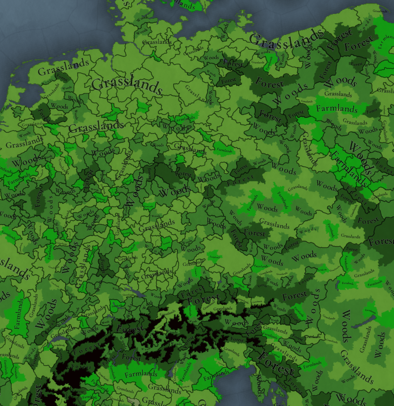
Terrain:
Climate.png

Topography.png

Vegetation.png

A bunch of changes after your feedback, especially on the Vegetation.

Development:
Development.png


Harbors:
I've noticed while preparing the Feedback post that we haven't posted the Natural Harbors of Europe, so I'll prepare another separate for them!

Cultures:
Cultures.png

There are some adjustments to the cultures, but not big changes.

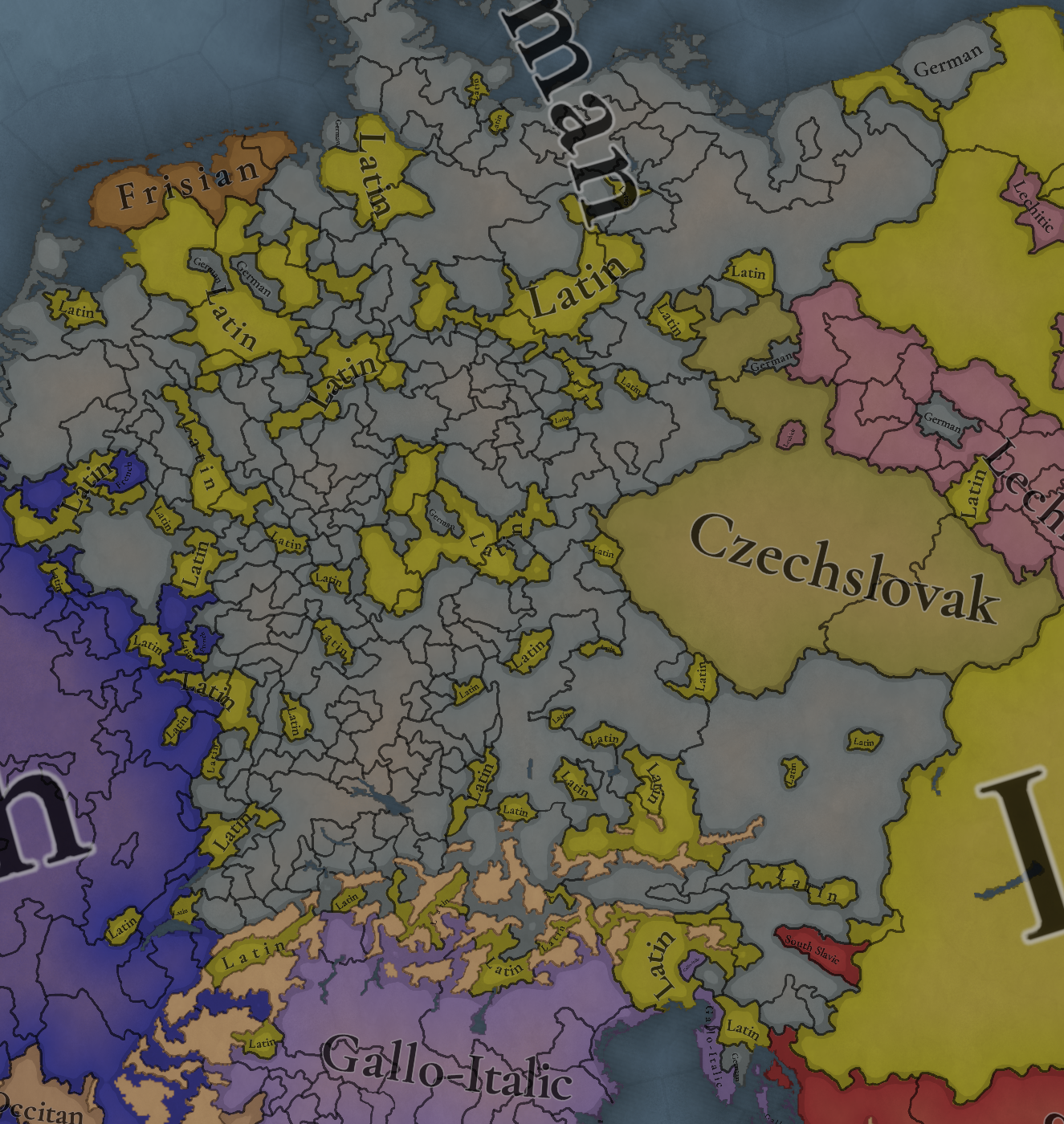
Languages:
Language.png

Dialects.png

Court Language.png

The first map is the dominant languages, the second is the dialects (which, I remind you, is primarily used for flavour, and close to the 'language' linguistical definition), and the third is the court language.

Religions:
Religion.png

Not many changes in the religious map, only a few Waldensians were added to Austria.

Raw Materials:
Raw Materials.png

Lots of changes!

Markets:
Markets.png

We haven't changed the market centers, you may notice some differences with the Tinto Maps post, which depend on the constant balancing we keep doing to this feature.

And that's all for today! Remember that on Friday we will be taking a look at a German country, Bavaria. Cheers!
 
  • 76Like
  • 52Love
  • 8
  • 6
  • 1
Reactions:
In general there are many improvements I like, e.g. the Bavarian borders now better represent the divisions, the borders of the Bishopric of Havelberg, Alsace, Holstein, Toggenburg and of the Margraviate of Burgau to name just a few. There are still some improvements I would personally make. Here's a list grouped by geographics from north to south (for now only for the political ownership because other things need more time to check):

Northern Germany:
- What I think is Gollnow, should be owned by Stettin.
- Lebus was conquered by Brandenburg in 1325. Its bishop fled to Poland until 1354, so a vassal tag of Brandenburg wouldn't represent this either, I'd say.
- Parchim, Malchow and Malchin should be owned by the tag Parchim (rename Waren).
- Güstrow and Waren should be owned by the tag Güstrow.
- Oldenburg should lose Elsfleth to Friesland, as they acquired it only in 1350
- I would've liked to see Wildeshausen to represent Brema's southern territories below Bremen.
- At least (Neu-)bruchhausen owned by (Neu-)bruchhausen would have been neat. The provinces there seem to have been redrawn.
- H.P. is supposedly Holstein-Pinneberg owned by Schaumburg, isn't it?

Central Germany:
- Meiningen's overlord in 1337 was Würzburg. In 1344, its overlord, bishop Otto II, even asked Louis the Bavarian to grant it the same rights as the Free City of Schweinfurt.
- Chemnitz should go to Meißen, not Landsberg.
- Torgau's county was still ruled by the Counts of Torgau in 1337 (Bodo of Torgau in 1337).
- Pirna was owned by Bohemia from the reign of Václav II (1293) until the reign of Wenceslaus, King of Germany (1405). This is why I suggested adding Bischofswerda in its east, and give that to Misnia (Bishopric of Meißen). Nearby Königstein actually derives its name from this period (there were no Saxon emperors or kings at that time). Alternatively, Pirna could be changed to Dohna and then owned by the Burgraviate Dohna.
- Schwarzenberg would be renamed to Waldenburg if it was up to me, as there were many smaller independent states in this area. The Lordship of Waldenburg (Heinrich of Waldenburg in 1337) would represent the three small independent worldly rulers of the region (Burgraviate of Meißen and small territories owned by Colditz), as a third Meißen would probably be too much at that point.
- Sangerhausen should be renamed to Allstedt, because it's owned by Allstedt (tag).
- Braunlage, as it used to be called, could become Walkenried, which would be its own tag, an imperial abbey.
- Mühlhausen is rather huge, so I would've hoped for the addition of Mainz's Eichsfeld (Heiligenstadt and maybe even Langensalza)
- Wertheim, owned by the Counts of Wertheim, could be added next to Lohr and Würzburg. It existed until the mid of the 16th century.
- Kaiserslautern was owned by Balduin of Trier since 1332. The Palatinate didn't get it until 1356. See also https://www.1000-jahre-mainzer-dom....toren/Burgard/burgard_BalduinvonLuxemburg.pdf or https://de.wikipedia.org/wiki/Kaiserpfalz_(Kaiserslautern).
- Kirrweiler maybe could be added as western territory for Spira (Bishopric of Speyer), now that a Palatine connection to Kaiserslautern is no longer needed.
- Birkenweil could be renamed to Grumbach to also include the Rhinecounty ("Rheingrafschaft").
- Rees could be changed to Duisburg, which would be owned by Berg, as Duisburg was far more important as a former free city.
- Cochem should be owned by Trier and not by Daun. Daun was an extremely small state, so it certainly shouldn't be that big. If you want to add here some interesting borders, then Virnburg for the Palatinate would be a neat option.
- Ahrweiler could be changed to Neuenahr, as Cologne's territory in this region was extremely minor. Neuenahr would then be its own tag.
- Gumersbach should again change back to Mark, which got it in the 13th century.
- Sadly you didn't add the Free City of Cologne

Southern Germany:
a) Bavaria
- Miesbach was owned by the County of Hohenwaldeck which broke free from Freisinger overlordship around 1300, so they should be independent in 1337.
b) Franconia
- Schwabach was owned by Nassau(-Hadamar) until 1364, so it shouldn't be owned by the Burgraves of Nürnberg in 1337.
- Kulmbach was still in the possession of the Counts of Weimar-Orlamünde. It was only inherited by the Burgraves of Nürnberg in 1340.
- Pegnitz should be owned by Leuchtenberg. They only sold it to Bohemia in 1357, and Pegnitz was never owned by Bamberg.
- Mellrichstadt was acquired by Würzburg in the 13th century, so it should be owned by it and not Henneberg in 1337.
- Brückenau belonged to the Abbey of Fulda until 1816. You previously made it an independent tag but it was always Fulda's (with some rebellions in between).
- Schweinfurt would be, I think, better represented as subjugated Free City (vassal of Henneberg), as they bought their freedom themselves only a few years after the game starts.
- Hohentrüdingen owned by the tag Truhedingen could be carved out from Dinkelsbühl and Weißenburg. .
c) Swabia
- Kaufbeuren's removal is odd. It was an Imperial City, so certainly shouldn't be part of Augusta Vindelicorum.
- Heidenheim was owned by the Counts of Helfenstein, so it should be one tag.
- Kirchberg is far bigger than it was historically. The western part of it could become Ehingen held by Berg-Schelklingen and the eastern part Mindelheim held by Hochschlitz.
- Riedlingen should be owned by Hohenberg, as they bought it from the Habsburgs in 1314 (Hohenberg owned it until 1364). The Habsburgs only got it back in 1680, when Riedlingen's burghers paid back the mortgage on their own expenses.
- Triberg should also be owned by Hohenberg, who inherited it in 1325 from the Counts of Triberg. It only became part of Austria in 1355.
- Calw was sold to Württemberg in 1345 by the Palatine Counts of Tübingen. One half of the County of Calw was already acquired by Württemberg in 1308, so this might have caused some confusion here.
- Oberndorf should be owned by the Duchy of Teck (or alternatively changed to Sulz, owned by the Counts of Sulz)
- Nagold should be owned by Hohenberg; it was only bought by Württemberg in 1364.
- Villingen, as far as I'm concerned, should be changed to the Free City of Rottweil, which was far more important than Villingen. The current Austrian exclave was extremely miniscule compared to others like e.g. Altdorf.
- Balingen was owned by Zollern-Schalksburg and didn't join Württemberg's column until 1403 (Zollern-Schalksburg also owned Mühlheim). Württemberg's only southern territory at that time was Sigmaringen, which they again lost in 1399.
- Illereichen was owned by the Lords of Echberg from 1330 until 1667 (see https://web.archive.org/web/20160304001409/http://www.altenstadt-vg.de/index.php?id=0,26) and not the Counts of Kirchberg. The Lords of Echberg also got Mindelheim from Hochschlitz in 1339.
- Bonndorf belonged to the Landgraviate of Stühlingen until 1614. Until then the Counts of Lupfen were the Landgraves, not the Habsburgs.

Austria:
- It appears that you decided to remove many exclaves. But it wouldn't be the HRE without bordergore, so I hope you'll return to the previous iteration and maybe even expand there with more. Kirchberg and Attersee again to Bamberg (or switch Attersee with Mondsee for Lower Bavaria). Waidhofen an der Ybss, Oberwölz and Enzersdorf to Freising. Traismauer to Salzburg. Velden, Riedegg, (Eferding) and St. Pölten to Passau.
- I would've liked to see the County of Schaunburg as vassals of Austria. The Luxembourg Emperors tried weakening the Habsburgs by granting them more priviliges but this failed. However, they retained several exemptions until the reign of Maximilian I. Schaunberg bought the city of Eferding from Passau in 1367, which at that time was actually the most important town of the area.
- Kranj / Krainburg was owned by the Counts of Ortenburg. You coul add Stein in Krain (Kamnik) to still ensure a connection for Austria.
- Spittal should take some parts of Hermagor to have nicer borders for the Ortenburgs. Maybe Gmünd for Salzburg could be added back again.
- Kirchdorf (an der Krems) was owned by Bamberg (just like in the previous map version).
- Sankt Georgen should also be owned by Bamberg.
- Novo Mesto could be split to add Klingenfels for Freising.
- Bistrica and Rijeka should be owned by an independent tag, the Lords of Duino. Maybe even Duino could be carved out of Trieste. After all, they no longer accepted the suzerainity of Gorizia and freely changed their fealty to the Habsburgs in 1366.

Bohemia:
Ceterum censeo, Eger should became a Free City subject of Bohemia, as mentioned in the Bohemian flavour thread:


- Eger should basically be 100% North Bavarian. As mentioned earlier, it wasn't incorporated into Bohemia and the Bohemian kings only had a representative who dealt with his subjects, i.e. there also were no officials (which could've been Bohemian). You also redrew the province to even better match with the territory of the Free City of Eger, so it should be even clearer. As per usual, there likely were also some Bohemian traders in the city but they likely didn't make up a sizeable proportion.
- Sulzbach should also have a high proportion of North Bavarian pops. More than half of it is part of the Bavarian language group.

You can look at this modern map but actually Franconian pushed eastwards because of Nuremberg's influence. Also note that the south got changed because of a massive migration of Austrian (Danube Bavarians) Protestants to Regensburg which shifted Regesnburg to Danube Bavarian, and thereafter Regensburg's new dialect influenced the surrounding area and expanded.

Neustadt am Kulm is also a curiosity, as it belonged to Brandenburg-Bayreuth and was therefore Protestant which usually spoke Franconian.
1740121981844.png
 
Last edited:
  • 40
  • 20Like
  • 4Love
  • 3
Reactions:
Can i ask what is the logic behind high and low German languages being unified?At this point i belive it's remaining as such so it's just to understand what constitutes a whole new language and what doesn't
 
  • 11Like
  • 7
Reactions:
Good job! as always I have a few questions and requests:

1-Are Margraviates and marches considered tier 2 countries?
2-Can you separate the three Rhaetian languages from the Gallo-Italic group please? Even though it's small I think they can a group on their own considering how different they are from the northern Italian dialects
3-Can you rename the tier 1 Swiss republics Cantons it would be very fitting!
4-It's not in Germany but I have recently noticed that the Livonian Order is just called Livonia, why?
5-Since it seems you renamed it what's the full name of the Palatinate? The official name was the Electorate of the Palatinate only after the golden bull of 1356, before that in it was the County Palatinate of the Rhine so is there a dynamic change of the name?
6-Is there an event for the enstablishment of the free imperial city of Cologne which historically separated itself from the Archbishopric in 1475?
7-I noticed that Nassau was a formable in the last Tinto Talks, in how many tags is it split at the start and what are their names?
8-Have you thought about representing the Frisian Freedom as an IO similar to Swiss Confederation rather than a unified tag since that would be more appropriate?
9-The Archduchy wasn't a thing yet so why is Austria so "centralized" in 1337? I can maybe understand Austria and Styria being one thing even though both of them are duchies on the same hierarchical level and are jointly ruled ruled by the two Habsburg brothers(which I hope it can be portrayed to PU mechanics somehow) but not for the duchy of Carinthia which only became part of the Habsburg domain in 1335 and by 1337 still had high degrees of authonomy and pretty much the same can be said for the March of Carniola, I feel like the current PU mechanics that you showed us are perfect to represent the Habsburg monarchy so why don't you use them?
Screenshot_20250214_174715_Chrome.jpg
 
Last edited:
  • 11Like
  • 1Love
Reactions:
The first map is the dominant languages, the second is the dialects (which, I remind you, is primarily used for flavour, and close to the 'language' linguistical definition), and the third is the court language.
why the East Slavic and West Slavic languages were split, but German remained one language? There were 2 writing standards (Hansesprache for low german and a bit later Hochdeutsch with Luther)
 
  • 7Like
  • 6
Reactions:
Yikes, what happened to the color scheme of the terrain map mode?

Flatland - plateau is totally indistinguishable for me (probably a color blind thing once again?).
Is Plateau green now?

At risk of sounding like a broken record: green-yellow-orange is near-impossible color scheme for the majority of colorblind people.
About 1/12 men has colorblindness. Considering the PDX game demographic, 1/12 players will have issues with these colors.

Regardless of color, flatlands-plateau really needs a better contrast (imo there was nothing wrong with the previous scheme, was the previous color scheme really that poorly received?)

EDIT - color blindness simulation
Normal visionRed weak/blindness simulation Green weak/blindness simulationBlue weak/blindness simulation
1739801407071.png
red weak
1739801828477.png
green weak
1739801834577.png
blue weak
1739801845884.png
red blind
1739801711409.png
green blind
1739801696137.png
blue blind
1739801739188.png
 
Last edited:
  • 22
  • 17Like
  • 9
Reactions:
Any plans to increase the weighting of rivers for trade centres, or to cause mountains to decrease it more? Still kinda weird for Switzerland to be in Genoa.

If no, that’s valid; maybe the trade system just can’t really simulate river trade to that extent. But I’d like to know if that’s the case, or if there’s plans to adjust it further.
 
  • 9
  • 4Like
  • 1
Reactions:
Why does the bishopric of Brandenburg own the namesake city? It should be the capital of the Mragraviate while the bishop had his residence in Ziesar which should be split
Screenshot_20250217_180749_Chrome.jpgScreenshot_20250217_180732_Chrome.jpg
Kinda like this
 
Last edited:
  • 4Like
Reactions: