
Tinto Maps #13 Maghreb Feedback
- Thread starter Pavía
- Start date

-
We have updated our Community Code of Conduct. Please read through the new rules for the forum that are an integral part of Paradox Interactive’s User Agreement.
You are using an out of date browser. It may not display this or other websites correctly.
You should upgrade or use an alternative browser.
You should upgrade or use an alternative browser.
The term “Moroccan” populations typically refers to Arabic-speaking groups, the precursors to today’s Moroccan Arabs. Yet, in his 1599 publication Description of Africa, Luis del Mármol Carvajal observed that Arabs were actually quite scarce in Morocco in comparison with EU5 depiction.
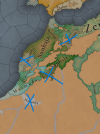
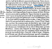
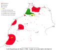
I located a 17th-century French edition of his work (noting that its language differs somewhat from modern French) and captured several screenshots, each marked with chapter or page numbers, to support my point. I’ve also included a map created by a Reddit user illustrating Mármol Carvajal’s descriptions. If you’d like to see more screenshots, please let me know.
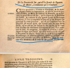
For example, Mármol Carvajal describes Marrakesh—then simply called “Morocco” (or "Maroc" in the screenshot)—as an entirely Berber city, a stark contrast to its modern, Arabic-speaking identity. Although urban centers like Fès did host Arabic speakers even in the sixteenth century, the vast majority of the country remained Amazigh-majority, with only a handful of Arab tribes roaming the countryside.
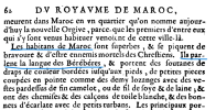
Hassania culture is also overrepresented. In reality, Arab tribes were so few that they would barely register beyond a handful of Bedouin or Hassania enclaves. It wasn’t until after the Char Bouba War in the 18th century that Hassaniya exerted significant influence over southern Amazigh communities. The Arab victory led to widespread cultural and linguistic Arabization, as Berber tribes gradually adopted the Hassaniya dialect of the Beni Hassan in place of Tamazight.
Apologies—the screenshots I took are all in French, as I couldn’t find an English version of Description de l’Afrique by Luis del Mármol Carvajal. If anyone would like a translation, feel free to let me know. Also, these are just a fraction of the excerpts I captured; if you'd like more, don’t hesitate to ask.
References:
Edit (Translation of the screenshots):
It’s important to note that this description dates to nearly 250 years before the game’s start, meaning the Arabization of the country should be less, not more. All the screenshots I shared are from the section on the Kingdom of Marrakech. There is also a section where the author discusses the Kingdom of Fes, but including that would require too many screenshots. My main point is that the map I shared summarizes Carvajal’s description .
I located a 17th-century French edition of his work (noting that its language differs somewhat from modern French) and captured several screenshots, each marked with chapter or page numbers, to support my point. I’ve also included a map created by a Reddit user illustrating Mármol Carvajal’s descriptions. If you’d like to see more screenshots, please let me know.
For example, Mármol Carvajal describes Marrakesh—then simply called “Morocco” (or "Maroc" in the screenshot)—as an entirely Berber city, a stark contrast to its modern, Arabic-speaking identity. Although urban centers like Fès did host Arabic speakers even in the sixteenth century, the vast majority of the country remained Amazigh-majority, with only a handful of Arab tribes roaming the countryside.
Hassania culture is also overrepresented. In reality, Arab tribes were so few that they would barely register beyond a handful of Bedouin or Hassania enclaves. It wasn’t until after the Char Bouba War in the 18th century that Hassaniya exerted significant influence over southern Amazigh communities. The Arab victory led to widespread cultural and linguistic Arabization, as Berber tribes gradually adopted the Hassaniya dialect of the Beni Hassan in place of Tamazight.
Apologies—the screenshots I took are all in French, as I couldn’t find an English version of Description de l’Afrique by Luis del Mármol Carvajal. If anyone would like a translation, feel free to let me know. Also, these are just a fraction of the excerpts I captured; if you'd like more, don’t hesitate to ask.
References:
- Lalâ Lgazri, Description de l'Afrique de Luis del Mármol Carvajal, édition 1599 (in 17th-century French). Google Books
- “Char Bouba War,” Wikipedia
Edit (Translation of the screenshots):
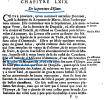
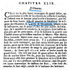
- Efcur Province (an old name for a region): The author gives its exact location, stating that it lies between the Green Mountain (the frontier of the Dukkala province near the Tensift River), separated from Tadla by the Oued El Abid, and bordered to the east by the Atlas Mountains. The inhabitants are sedentary Africans (Berbers/Amazigh) of the Masmuda branch.
- The map I created shows elements that need to be removed.
- Sus: All its inhabitants are Berbers of the Masmuda tribe.
- The citizens of Maroc (Morocco): Referring to the old French name for Marrakech—its inhabitants speak Berber languages.
- Hentete: All its inhabitants are Masmuda.
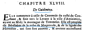
- Guidimiva: All its inhabitants are Masmuda.
- Gesula: Described by the author as the region between the provinces of Daraa and Sus—all its inhabitants are Masmuda.
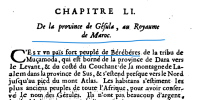
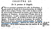
- The province of Dukkala: A region where many Arabs roam, but also where many Berbers reside. (The author later elaborates on the linguistic details of each tribe, which align with the map made by the Redditor.)
It’s important to note that this description dates to nearly 250 years before the game’s start, meaning the Arabization of the country should be less, not more. All the screenshots I shared are from the section on the Kingdom of Marrakech. There is also a section where the author discusses the Kingdom of Fes, but including that would require too many screenshots. My main point is that the map I shared summarizes Carvajal’s description .
Attachments
-
 7.png458,8 KB · Views: 0
 -
 Cultures.png1,4 MB · Views: 0
 -
 Screenshot 2025-05-18 202506.png1,5 MB · Views: 0
 -
 Screenshot 2025-05-18 204309.png201 KB · Views: 0
 -
 Screenshot 2025-05-18 204515.png375,9 KB · Views: 0
 -
 Screenshot 2025-05-18 204557.png108,4 KB · Views: 0
 -
 Screenshot 2025-05-18 204934.png155,8 KB · Views: 0
 -
 Screenshot 2025-05-18 205147.png243,6 KB · Views: 0
 -
 Screenshot 2025-05-18 205914.png368,8 KB · Views: 0
 -
 Screenshot 2025-05-19 004239.png272,1 KB · Views: 0
Last edited:
- 13

- 2
Somehow we started with an overabundance of Locations with Stone and ended up with none whatsoever outside of Morocco, what? The Atlas Mountains are right there...

- 6
- 1
Assuming I initiate a Maghrebi Reconquista (which would be a lovely non-canonical mission to have) to reestablish the Catholic Church, would the city/region names automatically revert to their original Latin/Greek/Punic names from Roman times once Catholic rule is reinstated, or if they get invaded by a Catholic nation?
Tunis -> Kartago
Annaba -> Hippo
Tangiers -> Tingis
Sfax -> Taparura
Sousse -> Hadrumetum
Algeris -> Icosium
Constantine -> Cirta
Tlemcen -> Pomaria
etc.
Also, can extinct ethnicities/languages be revived? African Romance, Punic...
Tunis -> Kartago
Annaba -> Hippo
Tangiers -> Tingis
Sfax -> Taparura
Sousse -> Hadrumetum
Algeris -> Icosium
Constantine -> Cirta
Tlemcen -> Pomaria
etc.
Also, can extinct ethnicities/languages be revived? African Romance, Punic...
Last edited:
- 1
- 1
- 1
Are there any remnants of the Afāriqah / Roman Africans left? According to wiki African Romance may have survived to the 14th or 15th century or even later.
- 1
Not by this point in time.Are there any remnants of the Afāriqah / Roman Africans left? According to wiki African Romance may have survived to the 14th or 15th century or even later.
The last remains of Christianity were erased by the almohads and by then they were already just a few thousands people concentrated around Tunis.
Not by this point in time.
The last remains of Christianity were erased by the almohads and by then they were already just a few thousands people concentrated around Tunis.
African Romance - Wikipedia
I hope not, when Spain and Portugal historically conquered Maghrebi cities they called them by their versions of existing toponyms, they didn't scrounge up Latin placenames from a millenium before. You can rename them yourself if you'd likeAssuming I initiate a Maghrebi Reconquista (which would be a lovely non-canonical mission to have) to reestablish the Catholic Church, would the city/region names automatically revert to their original Latin/Greek/Punic names from Roman times once Catholic rule is reinstated, or if they get invaded by a Catholic nation?
Tunis -> Kartago
Annaba -> Hippo
Tangiers -> Tingis
Sfax -> Taparura
Sousse -> Hadrumetum
Algeris -> Icosium
Constantine -> Cirta
Tlemcen -> Pomaria
etc.
Also, can extinct ethnicities/languages be revived? African Romance, Punic...
- 1
There's records of Latin speakers in the Aurès into the 15th century, some remnant of Roman Africa survived past the AlmohadsNot by this point in time.
The last remains of Christianity were erased by the almohads and by then they were already just a few thousands people concentrated around Tunis.
There's records of Latin speakers in the Aurès into the 15th century, some remnant of Roman Africa survived past the Almohads
This is amazing, I didn't know that to be honest but are we talking about a sizable minority or a handful of villages scattered around the Maghreb which accounted for a few hundred people at best ?
I mean at this point Christianity was far beyond being on its last leg.
Last edited:
In the previous thread we found reasonable evidence that there could be some minorities left.Are there any remnants of the Afāriqah / Roman Africans left? According to wiki African Romance may have survived to the 14th or 15th century or even later.
- 1
With the notable exception of the area around Gafsa and, possibly the island of Djerba, it was mostly tiny isolated rural communities.This is amazing, I didn't that to be honest but are we talking about a sizable minority or a handful of villages scattered around the Maghreb which accounted for a few hundred people at best ?
I mean at this point Christianity was far beyond being on its last leg.
- 1
- 1